Cabo de HornosLand of the Yagán (Yámana), where the continent ends and the extraordinary begins
History, Nature and Opportunities in Chile's Southernmost Inhabited Commune
SOUTH OF THE MAPS
The Yagán (Yámana) travelled these channels for thousands of years in bark canoes, with a fire always burning on board, and along the Beagle Channel they left the shell middens that can still be made out in the grass at Wulaia. For them there was no border: there were tides, mussels, sea lions and the lenga and coigüe forest that covers the slopes of Navarino.
Then came the Dutch who rounded the cape in 1616, FitzRoy's Beagle, the English missionaries, the gold prospectors and, in 1953, a Chilean Navy detachment that built on the shore of the channel the town now called Puerto Williams. Since then the commune has been an outpost of sovereignty and science, with the Dientes de Navarino range at its back and the legendary cape some twelve hours away by sea.
Here the warmest month barely exceeds ten degrees on average, it rains little but in almost every month, the December day lasts more than seventeen hours and the June day less than eight. Firewood, the west wind and the Beagle's southern king crab are the common language. Whoever arrives is not buying a view: they are getting a glimpse of a way of life at the edge of the last passage.
Version 1.0 · Expanded edition · October 2026
The Commune at a Glance
The essential data on Cabo de Hornos at a glance. Each figure is developed in the corresponding section.
Administrative identification and reference data11 rows
| Fact | Detail |
|---|---|
| Official name | Commune of Cabo de Hornos (current name since 2001, Law 19,726; formerly “Navarino”) |
| Region / Province | Magallanes and Chilean Antarctica / Antártica Chilena |
| Capital | Puerto Williams, on the north coast of Navarino Island |
| Civic center coordinates | 54°56′ S, 67°37′ W |
| Area | 15,578.7 km² (BCN) |
| Elevation | 6 m s.n.m. in Puerto Williams |
| Dialing code | +56 61 (Magallanes) |
| Time zone | UTC−3 all year (Magallanes time zone) |
| Climate classification | Cfc, subpolar oceanic; tundra on the summits |
| Anniversary of Puerto Williams | November (founded in 1953); the exact day varies by source |
| Municipality | Ilustre Municipalidad de Cabo de Hornos (Municipality of Cabo de Hornos); mayor Patricio Fernández Alarcón. It also administers the Antártica commune |
Overview
Cabo de Hornos is Chile's southernmost inhabited commune: 15,578.7 km² of channels, islands and open sea where 1,750 people live (2024 Census), barely 0.11 inhabitants per square kilometer. Almost all of that population is in Puerto Williams, the commune and provincial capital, on the north coast of Navarino Island, facing the Beagle Channel; the rest is spread across coves such as Puerto Toro, one of the southernmost permanent settlements in the world. Beyond lie the Hornos archipelago, Wollaston and Hermite, Hornos Island with its lighthouse, and the Diego Ramírez Islands, a group of islets about 60 km south of Hornos Island that also form part of the commune.
Its role in the territory is not productive but one of sovereignty, science and access. The Chilean Navy has maintained a naval base in Puerto Williams since 1953; the Cape Horn Biosphere Reserve, the Omora Ethnobotanical Park and the Sub-Antarctic Center give the commune the function of a southern laboratory; and Puerto Williams is the embarkation point that Silversea, the only cruise line that embarks there, uses for its Antarctic voyages. Everything that does not exist here —a higher-complexity hospital, wholesale commerce, most paperwork— is in Punta Arenas, 292 km away as the crow flies and an hour by air.
The contrast with its most similar neighbor is instructive. Puerto Natales, the other tourist gateway of Magallanes, can be reached by bus and has an active market for private parcels. In Cabo de Hornos there is no road to the mainland and, on Navarino, 93.6 % of lots are state-owned (fiscal): whoever wants land does not buy it from a private seller but leases it or applies for it from the State. Understanding that difference is understanding the whole commune.
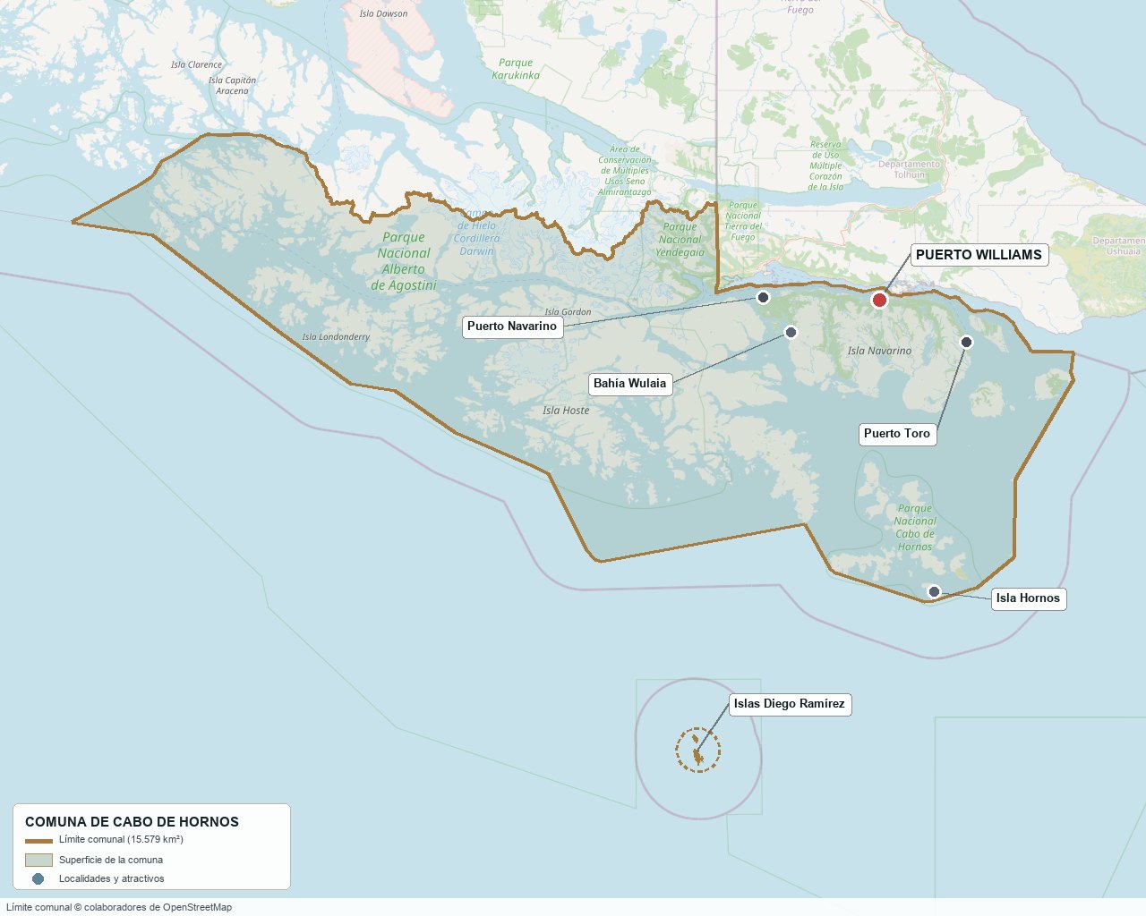
Commune boundary according to OpenStreetMap open data
§ 03 Location, Geography and Territory View
Where Cabo de Hornos is, what it is built on and why its land is hardly ever traded.
3.1 Location
Puerto Williams lies at 54°56′ S and 67°37′ W, on the north shore of Navarino, about 45 km as the crow flies from Ushuaia, which sits across the Beagle Channel, in Argentina. Punta Arenas is 292 km away as the crow flies (an hour by air, between 27 and 34 hours by ferry) and Santiago about 2,400 km, reachable only via Punta Arenas. The commune comprises Navarino (about 2,500 km²), Hoste (4,117 km²), Gordon, Londonderry, Wollaston, Hermite, Hornos, the islands of Picton, Lennox and Nueva, and the Diego Ramírez Islands. Picton, Lennox and Nueva were the center of the dispute that nearly brought Chile and Argentina to war in 1978; the 1977 Arbitral Award and the 1984 Treaty of Peace and Friendship left them on the Chilean side.
Puerto Williams · 54°56′ S, 67°37′ W
3.2 Terrain and setting
Puerto Williams occupies a narrow strip between the channel and the first foothills of the range, on a coastal terrace that barely rises above sea level. Behind it rise the Dientes de Navarino, summits above 1,100 m (sources give between 1,118 and 1,195 m), and Cerro Bandera, at about 610 m, which is the town's short climb. The vegetation of Navarino is arranged in bands: deciduous lenga and ñire forest in the north, humid evergreen Magellan coigüe forest in the center and Magellanic tundra in the south, toward Lake Navarino and Lake Windhond. In the outer archipelago, Hornos Island measures 30 km² and has a maximum elevation of 425 m, on peat-covered rock.
3.3 Hydrography
Main bodies of water in the commune6 rows
| Watercourse | Role in the territory |
|---|---|
| Beagle Channel | Axis of the commune: 240 km long and at least 4.8 km wide at its narrowest; it is the access, supply and crossing route to Ushuaia |
| Róbalo River | Its bridge is the entrance to the Dientes de Navarino circuit; nearby is the cove with the Universidad de Magallanes concession |
| Ukika and Douglas rivers | Watercourses of the island, cited alongside the Róbalo among the main rivers of Navarino |
| Lakes Navarino, Windhond and Pilushejan | Inland bodies of water in the south of the island, within the tundra zone |
| Huairavo urban wetland | Declared an urban wetland by the Ministry of the Environment (Res. Ex. 237 of April 3, 2024); the zoning plan protects it |
| Drake Passage | Open sea between Hornos Island and Antarctica, about 800 km wide |
3.4 Soils
No soil survey has been published at commune scale. What is known comes from vegetation cover and the Navarino Territorial Management Plan (IDOM, 2022): the north of the island, under lenga and ñire forest, has forestry, agricultural and livestock potential; the center and south are peat, tundra and rock. The Puerto Williams zoning plan reserves an entire zone (F2) for the peat bogs.
- Advantage: lenga and ñire forest soil in the northern strip of Navarino, with local firewood and potential for gardens and small-scale grazing (the Huertos Familiares lots measure between 0.48 and 1 ha).
- Limitation: constant moisture creates waterlogged peat bogs, poorly suited to foundations; the zoning plan sets a floor area ratio of 0.005 for them.
- Risk: flooding and tsunami within the urban area (zones AR1 and AR2 of the zoning plan) and avalanches or rockfalls in the gullies (AR3). The beaver, introduced in 1946 in Tierra del Fuego, damages the lenga forests.
- Real estate implication: according to the Territorial Management Plan (IDOM, 2022), the state-owned (fiscal) land available within the urban boundary is largely peat bog; the land with the most residential opportunity is allocated to the Chilean Navy.
§ 04 Climate and Seasonality View
A climate that never quite becomes polar and never stops being cold: no summer or winter extremes, but not a single warm month.
Puerto Williams has a subpolar oceanic climate (Köppen Cfc), according to the Dirección Meteorológica de Chile (Chilean Meteorological Directorate) fact sheet, with tundra on the summits. The mean annual temperature is 6.3 °C, with a range of only 8.4 °C between the warmest month (January, 10.3 °C) and the coldest (July, 1.9 °C). The Beagle Channel moderates the extremes: mean minimums are positive from October to April. The data correspond to the 1991-2020 normals of the Guardiamarina Zañartu station, the only one in the commune with a long record; they do not represent the islands most exposed to the west and south.
Reference climate parameters (1991-2020 normals, Guardiamarina Zañartu station)9 rows
| Parameter | Typical value | Comment |
|---|---|---|
| Mean annual temperature | 6.3 °C | Mean maximum 11.0 °C and mean minimum 1.5 °C |
| Warmest month | January · 10.3 °C | Mean maximum 15.4 °C |
| Coldest month | July · 1.9 °C | Mean minimum −2.0 °C |
| Heat record | 26.1 °C | Since 1968 |
| Cold record | −12.6 °C | Recorded in June |
| Annual precipitation | 497 mm | Between 30 mm (October) and 53 mm (February) per month |
| Days with precipitation | 94 per year | Drizzle and snow; 10.6 days in January and 6.2 in August |
| Prevailing wind | West, ~10 knots | Average of observations 2012-2026 (Windfinder); on the outer islands it is much higher |
| Summer and winter daylight | ~17 h and ~7 h | Astronomical calculation at 55° S for December and June, not station data |
Rain is not concentrated in a single winter, as in the south-central region: little falls (between 30 and 53 mm per month) but it is spread over 94 days a year, one in four. That constant moisture, with temperatures that are always low, explains the peat bogs that cover much of Navarino and why drainage and foundations matter more than irrigation.
§ 05 History: More Than Seven Thousand Years on a Timeline View
It is the history of two overlapping sovereignties: that of the canoe peoples who needed no border, and that of the States that do.
-
+7,000 years ago
The first canoe peoples
Excavations on the north coast of Navarino document a complete maritime sequence going back some 7,000 years. The Wulaia shell middens, with their dome-shaped mounds and fish traps, are the emblematic site.
-
1616
Rounding the cape
The Dutchmen Schouten and Le Maire sail around the southern tip of the Americas for the first time and call it Kaap Hoorn, after the city of Hoorn.
-
1624
First European landing on Navarino
A Dutch expedition under L'Hermite makes landfall on the island; the name of Hermite Island recalls that expedition.
-
1830 – 1833
The Beagle and Jemmy Button
FitzRoy names Navarino after the naval battle of 1827 and takes four Fuegians to England, among them Jemmy Button. In January 1833 the Beagle's second voyage, with Darwin aboard, returns them to their homeland.
-
1859
The Wulaia massacre
Seven members of the Allen Gardiner Anglican mission, among them Garland Phillips, die in Wulaia Bay. Jemmy Button testifies in the 1860 inquiry.
-
1871 – 1886
Bridges' mission
Thomas Bridges settles in Ushuaia and compiles a Yagán-English dictionary of more than 30,000 words. In 1886 he founds the Harberton estancia, across the channel.
-
1884 – 1892
Epidemics and the first Chilean colony
A measles outbreak decimates the Yagán in 1884. In 1892, during the Tierra del Fuego gold rush, Puerto Toro is founded, the first Chilean settlement on Navarino.
-
1927
The commune of Navarino is born
DFL 8,583 of December 30 creates the Tierra del Fuego Department with four communes, among them Navarino.
-
1945
Cabo de Hornos National Park
Decree 995 of April 26 creates the park, which protects Wollaston, Hermite and Hornos Island: the southernmost national park in the world.
-
1953 – 1956
From Puerto Luisa to Puerto Williams
In 1953 the Chilean Navy founds a settlement first called Puerto Luisa; in 1956 it is renamed Puerto Williams, in honor of John Williams Wilson, who took possession of the Strait of Magellan in 1843.
-
1957 – 1967
Aerodrome and Villa Ukika
The Guardiamarina Zañartu aerodrome is inaugurated on February 22, 1957. In 1967 the Yagán families of Mejillones Bay are relocated to Villa Ukika, about 2 km from the town.
-
1977 – 1985
Arbitral award, near war and treaty
The 1977 Arbitral Award grants Chile the southern islands; Argentina rejects it in 1978. After mediation by Pope John Paul II, the Treaty of Peace and Friendship is signed on November 29, 1984 and exchanged on May 2, 1985. In January of that year the Navarino Law is published.
-
2001 – 2005
Name change and biosphere reserve
Law 19,726 changes the name of the commune from Navarino to Cabo de Hornos. On June 29, 2005 UNESCO declares the Cape Horn Biosphere Reserve, the only one in Chile that combines land and sea.
-
2022 – 2023
Cristina Calderón dies and the Sub-Antarctic Center opens
On February 16, 2022 Cristina Calderón, the last native speaker of Yagán, dies at the age of 93. On May 15, 2023 the Universidad de Magallanes' Cabo de Hornos Sub-Antarctic Center is inaugurated.
-
2026
New zoning plan and expedition hotel
On April 6 the update of the Puerto Williams zoning plan is published in the Official Gazette, after almost ten years of processing. Silversea expects to open its 150-room hotel for Antarctic voyages in October.
§ 06 Cultural Identity and Indigenous Peoples View
One in five inhabitants belongs to an Indigenous people according to the Social Household Registry: double the national average.
According to the March 2025 Social Household Registry, 18 % of the commune's inhabitants belong to an Indigenous people, compared with 20.6 % in the region and 9.2 % in the country. The territory's own people are the Yagán (Yámana), whose community lives mainly in Villa Ukika. There is no 2024 Census breakdown of Indigenous peoples for the commune, and the Yagán language was left without native speakers after the death of Cristina Calderón in 2022.
The cultural layers of Cabo de Hornos5 rows
| Tier | Visible traces today |
|---|---|
| Yagán (Yámana) | Wulaia shell middens; Villa Ukika (1967); Kipa-Ákar Craft Center (2003-04); Mejillones cemetery, a Historic Monument since 1976; Museo Territorial Yagán Usi (Yagán Usi Territorial Museum), with about 4,000 pieces; Comunidad Indígena Yagán de Bahía Mejillones (Yagán Indigenous Community of Mejillones Bay), with 94 members |
| Navigators and missionaries | The names on the map (Hoste, Gordon, Wollaston, Hermite, Hornos), the memory of Jemmy Button and of the Anglican mission, Bridges' dictionary |
| The Chilean Navy | Casa Naval No. 1 and the former headquarters of the Beagle Naval District (Historic Monuments, 2011); historic warehouses of the Naval Base; the yacht Micalvi, a 1925 hull sunk in the bay in 1962 and today a yacht club |
| Settlers and fishers | Puerto Toro, founded in 1892 and today home to a few dozen inhabitants who live off southern king crab; the road to Puerto Navarino and the former estancias of the north coast |
| Science and visitors | Omora Ethnobotanical Park (2000), Sub-Antarctic Center (2023), about 250 researchers a year, and the 1,217 trekkers of the 2024-25 season |
In daily life the mix shows in the makeup of local power: the municipal council elected in 2024 is made up of six women and is the only one in the country without men. The naval population, meanwhile, is renewed with each posting: according to La Prensa Austral (2024), most naval families have relatives in central Chile and not in Magallanes, which keeps part of the town in transit.
§ 07 Key Demographic Data View
7.1 Population and growth
Demographic indicators compared9 rows
| Indicator | Commune | Region | Country |
|---|---|---|---|
| Population, 2017 Census | 2,063 | 166,533 | 17,574,003 |
| Population, 2024 Census | 1,750 | 166,537 | 18,480,432 |
| Intercensal change | −15.2 % | 0.0 % | 5.2 % |
| Commune area | 15,578.7 km² | — | — |
| Population density (2024) | 0.11 inhabitants/km² | — | — |
| Foreign-born population | Withheld by the INE | 6.6 % | 8.7 % |
| Sex ratio 2024 | 101.4 | 98.1 | 94.3 |
| Demographic Dependency Ratio (IDD) 2024 | 45.0 | 45.4 | 46.5 |
| Elderly Index (IAM) 2024 | 21.5 | 87.1 | 79.0 |
7.2 Age structure (2024 Census)
Population distribution by age group5 rows
| Age group | Population 2024 | % Commune |
|---|---|---|
| 0 – 14 years | 447 | 25.5 % |
| 15 – 29 years | 289 | 16.5 % |
| 30 – 44 years | 595 | 34.0 % |
| 45 – 64 years | 323 | 18.5 % |
| 65 years and over | 96 | 5.5 % |
Two phenomena dominate. The first is the decline: the commune lost 313 inhabitants between censuses, 15.2 %, while the region held steady. The second is youth: the elderly index is 21.5, compared with 87.1 in the region, and the sex ratio fell from 137.7 in 2017 to 101.4 in 2024, a sign that contingents of single men were replaced by whole families.
The urban-rural breakdown of the 2024 Census was not available at the close of this edition. In 2017 Puerto Williams had 1,868 inhabitants and Navarino Island 2,015, so practically the entire population lives in the town; the Darwin and Hoste districts totaled 42 people. The commune is small but not rural in the productive sense: it is a town with an empty territory around it.
§ 08 Economic and Socioeconomic Data View
8.1 Poverty and social indicators (CASEN and Social Household Registry)
Social indicators compared6 rows
| Indicator | Commune | Region | Country |
|---|---|---|---|
| Income poverty, Casen 2022 | 1.2 % | 3.4 % | 6.5 % |
| Multidimensional poverty, Casen 2022 | 1.6 % | 6.9 % | 16.9 % |
| People in households lacking basic services (RSH 2025) | 7.3 % | 6.8 % | 13.1 % |
| Overcrowded households (RSH 2025) | 4.8 % | 5.2 % | 8.1 % |
| Indigenous population (RSH 2025) | 18.0 % | 20.6 % | 9.2 % |
| Foreign population (RSH 2025) | 3.0 % | 5.2 % | 6.7 % |
Poverty is very low: 1.2 % by income, against 6.5 % nationally. It does not reflect business prosperity but a public-salary economy: the Chilean Navy, the municipality, the hospital and State services, plus the 105 % zone allowance received by public employees in Puerto Williams. With such a small sample, the Casen survey has a wide margin of error, and the lack of basic services (7.3 %) is above the regional average.
8.2 Economic activity (SII) and municipal finances (SINIM)
Business structure and municipal finances12 rows
| Economic indicator (SII / SINIM) | Value |
|---|---|
| Registered businesses, 2024 | 239 (212 in 2021; 243 in 2022; 235 in 2023) |
| Reported salaried employees, 2024 | 706 |
| Business size, 2023 | 158 micro, 37 small, 3 medium, 3 large and 34 with no information |
| Commerce and vehicle repair, 2024 | 53 businesses · 388 workers |
| Accommodation and food services, 2024 | 40 businesses · 74 workers |
| Agriculture, livestock and fishing, 2024 | 25 businesses · 30 workers |
| Construction, 2024 | 24 businesses · 68 workers |
| Administrative and support services, 2024 | 19 businesses · 76 workers · sales of 1,176,054 UF |
| Public administration and defense, 2024 | 2 businesses · 48 workers |
| Total municipal revenue, 2024 (SINIM) | $4,986 million: 78.7 % Municipal Common Fund and 8.1 % own revenue |
| Municipal revenue executed, 2025 (Annual Public Report) | $5,625 million (+12.8 %); Municipal Common Fund of $4,413 million, 78.45 % |
| Municipal cash balance at the end of 2025 | $4,472 million; net result for the year of $1,379 million |
The table should be read with care. There are 239 businesses for 1,750 inhabitants, most of them micro and small. Commerce accounts for 388 of the 706 reported workers: a figure that does not fit a local retail sector of that size and that probably reflects one or two companies with staff declared here; the public data do not allow us to know. And the SII does not register naval personnel or the Naval Base staff, who are the commune's largest source of employment.
§ 09 The Productive Engine: Navy, Austral Tourism and Special Regime View
Cabo de Hornos does not live off its soil but off its position: it is sustained by the State, expedition tourism and a preferential tax regime.
9.1 The Chilean Navy and the public sector
The naval base is the largest employer. According to La Prensa Austral (February 2024), 270 naval personnel make up just over 40 % of the population of Puerto Williams, and that proportion rises if their families are added. To this are added the municipality (135 fee-based contractors in 2025 and 119 in 2024), the hospital, which had more than 40 staff in 2016, state services and the Liceo Bicentenario. The result is an economy in which demand for housing, commerce and services depends on State staffing levels and their postings.
Pillars of the communal economy and their measurable dimension8 rows
| Pillar | Measurable dimension | Source and year |
|---|---|---|
| Chilean Navy | 270 naval personnel, more than 40 % of the population of Puerto Williams | La Prensa Austral, 2024 |
| Municipality | $5,625 million in revenue; 135 fee-based contractors | Municipal Annual Report, 2025 |
| Trekking tourism | 1,217 trekkers from 37 countries on the Dientes de Navarino (549 Chileans, 124 Germans, 102 French) | Radio Polar, 2024-25 season |
| Cruise tourism | 6,010 cruise passengers in Puerto Williams | Mundo Marítimo, 2023-24 season |
| Cape Horn (island) | More than 10,000 visitors in the season | Radio Polar, 2024-25 |
| Air bridge | 13,254 passengers to Puerto Williams and 13,428 in the opposite direction, between October 2024 and March 2025 | Radio Polar, 2025 |
| Artisanal fishing | Southern king crab and false king crab from Puerto Williams and Puerto Toro; no quota or public figures by commune | Subpesca |
| Aquaculture | None in operation: the four salmon farming concessions in the Beagle Channel were declared lapsed in 2019 | Greenpeace; El Mostrador, 2019 |
9.2 Expedition tourism and gateway to Antarctica
Silversea is the only cruise line that embarks passengers for Antarctica from Puerto Williams, from late October to late March. In 2026 that bet becomes infrastructure: The Cormorant at 55 South, a 150-room hotel with an estimated investment of US$50 million, originally due to open in the 2025-26 season and which, after a delay, was announced for October 2026 (Emol, August 2, 2026). The model is the “fly-cruise”: the passenger flies from Santiago, sleeps in Puerto Williams and continues to Antarctica. At the same time, the State is investing in the town's multipurpose pier, at a total cost of $34,589 million, of which $20,599 million had been executed according to Subdere (2026), and the OMIL (Municipal Labor Office) rates the construction of the new Hotel Lakutaia as the commune's largest private project in terms of local employment.
9.3 Fishing, the salmon that never was, and livestock
Puerto Toro, founded in 1892, is one of the southernmost permanent settlements in the world and lives off southern king crab and false king crab. In 2018 the Ministry of National Assets observed that many fishers who operate in the Beagle Channel live in Punta Arenas and come down only to work. Salmon farming does not exist: four concessions of 3.36 ha each, granted in 2005 in the Beagle Channel and operated by Nova Austral, with permits for 138 cages, were declared lapsed by the Undersecretariat of the Armed Forces in June 2019, following complaints from environmental organizations and opposition from Indigenous communities. Livestock and forestry are marginal: northern Navarino has potential, but no production figures were found.
9.4 The special regime: Navarino Law and Austral Law
Law 18,392, published on January 14, 1985 and known as the Navarino Law, created a preferential customs and tax regime for the territory south of the Strait of Magellan, and remains in force until January 14, 2035. According to the analysis by García and Fecci in the Anuario de Derecho Tributario No. 13 (2021), two groups benefit. Companies with an approval resolution, which must be established in the area and have an industrial, mining, marine-exploitation, transport or tourism business activity, are exempt from first-category tax and VAT on their operations, and receive a 20 % bonus on their sales to the rest of the country. Residents and real estate in the territory receive the property tax exemption, VAT exemption on sales between residents, and subsidies for labor and investment.
The Austral Law (Law 19,606) adds a tax credit for investments in the Aysén and Magallanes regions, and Law 21,210 of 2020 extended the extreme-zone benefits to 2035 (SII, Circular 60 of 2020). The effect, according to that reading, is that real estate in the territory is exempt from property taxes and that anyone investing in tourism, transport or fishing can avail themselves of a regime that does not exist in the rest of Chile.
§ 10 Real Estate Market View
10.1 Available properties and property types
The visible private market is minimal. On October 7, 2026 the Yapo portal showed only three sale listings in the commune, all houses and none of them land; Portal Inmobiliario and Mercado Libre could not be consulted. No published rental listings were found, only an ad from a person looking to rent one bedroom with a budget of $600,000 per month. What does circulate are state-owned (fiscal) lots that the Ministry of National Assets leases or sells, and MINVU social housing. The Territorial Management Plan (IDOM, 2022) notes that land transactions on Navarino are mainly disposals of state-owned lots, at values below those of the rest of Magallanes.
10.2 Average price by property type (indicative, October 2026)
Indicative price ranges by property type6 rows
| Property type | Indicative price range | Notes |
|---|---|---|
| Habitable house in Puerto Williams | $105 to $140 million | Three listings on Yapo: 100 m² with an annex apartment and 3 bedrooms at $105 million (April 2026); 2016 house with 2 bedrooms at $140 million (September 2025). Sample too small for a statistical range |
| Prefabricated “take-down” house | $7.9 million | Panel house, immediate removal, on the Costanera (October 2025) |
| Urban lot (fiscal appraisal) | ~3 UF/m² residential · ~7 UF/m² commercial | Values from the IDOM zoning (2022): a minimum lot of 450 m² in zone A1 would equal about 1,350 UF |
| State-owned (fiscal) lot in Huertos Familiares or Barrio Industrial | $2.3 to $5.3 million (UF 72 to 164) | Commercial appraisal per lot of 0.48 to 1 ha; state-owned lots for lease or sale by the Ministry of National Assets (2022) |
| State-owned (fiscal) lot in Caleta Pantalones | $24 to $36 million (UF 741 to 1,117) | Lots of 8.5 to 12.25 ha, currently leased (IDOM appraisal, 2022) |
| Housing rental | No listings published | A search for a 1-bedroom rental offered $600,000 per month |
The pace of the market is set by the State. Under the Plan Navarino program (Ministry of National Assets, since August 2018), state-owned land was sold to tenants and residents for between $4 and $18 million; since 2022, 24 entrepreneurs lease lots of 0.5 to 1 ha. The SEREMI (Regional Ministerial Secretariat) has said it seeks to avoid inappropriate construction and speculative second homes on state-owned land. There were no recent tenders for state-owned lots in Puerto Williams that could be verified.
10.3 What determines price in Cabo de Hornos
Value drivers in this market, ranked by impact7 rows
| Factor | Price impact | How to check it here |
|---|---|---|
| Title deed versus fiscal lease or concession | Decisive | A lot held under a “lease” or “concession” cannot be sold. Check with the SEREMI de Bienes Nacionales Magallanes (Ministry of National Assets regional office) and review the registration at the Real Estate Registrar (Conservador de Bienes Raíces) of Cabo de Hornos, in Puerto Williams |
| Zoning plan zone | High | The zone (A1 to A4, B, C…) sets the minimum lot subdivision size (200 to 450 m² in the residential zones) and the uses. Request a preliminary information certificate from the municipal DOM (Municipal Works Department) |
| Flood or tsunami risk and peat bogs | High | Areas AR1, AR2, AR3 and zone F2 limit or raise the cost of construction: check against plans PRC-PW-AR and PRC-PW-ZR in the Official Gazette |
| Waterfront and the 80 m strip | High | Lot with channel frontage: the beach is for public use and can only be used through a maritime concession; the 20 m strip is a no-build strip |
| Cost of building and heating | Medium | Materials arrive by barge, labor is scarce, and heating relies on firewood or pellets. Request a formal quote before committing to a price |
| Proximity to the center and to transport links | Medium | The commercial zone was appraised at 7 UF/m² against 3 UF/m² for the residential zone; the aerodrome is about 1 km from the town |
| Property tax exemption (Navarino Law) | Low, constant | Reduces the cost of ownership; confirm with the SII how it applies to the specific property roll number |
§ 11 Territorial Planning in Cabo de Hornos View
What the Puerto Williams zoning plan, in force since April 2026, allows and prohibits, and what happens outside it.
The instrument in force is the Update of the Puerto Williams Municipal Zoning Plan (PRC), promulgated by the Gobierno Regional de Magallanes (Magallanes Regional Government) through Resolution T.R. No. 75 of June 30, 2025 and published in Official Gazette No. 44,417 on April 6, 2026. Its processing took almost ten years: the Strategic Environmental Assessment began in October 2016 and the file went through the Contraloría at least in 2019, 2021 and 2022 before final promulgation. It replaces the 1987 plan (according to the IDOM Territorial Management Plan, 2022). The plan covers only the urban boundary of Puerto Williams; the rest of the commune, almost all of Navarino and the islands, lies outside it and is governed by the rural regime.
Puerto Williams Zoning Plan areas and what they allow9 rows
| Zone | Permitted use | Key restriction |
|---|---|---|
| A1 · Mixed residential 1 | Housing, lodging, commerce, primary education, clinics, services and community centers | Minimum lot subdivision size of 450 m²; 60 inhab/ha; lot coverage 0.3; 2 floors up to 7 m; 5 m front setback; detached |
| A2 · Mixed residential 2 | As A1, plus outpatient clinics, secondary education and telecommunications | 300 m²; 100 inhab/ha; lot coverage 0.4; 2 floors up to 7 m; 3 m front setback |
| A3 · Mixed residential 3 | Housing, hotels, hostels, commerce, automotive services | 250 m²; 150 inhab/ha; lot coverage 0.4 (0.7 for other uses); 2 floors up to 7 m |
| A4 · Mixed residential 4 | Housing, hostels, local commerce and artisanal services | 200 m²; 150 inhab/ha; lot coverage 0.5 (0.6 for other uses); 2 floors up to 7 m |
| B1 · Civic Center amenities | Hotels, commerce, services, scientific, housing | 600 m²; lot coverage 0.7; up to 4 floors and 14 m, the greatest height in the town |
| B3 · Tourism-science | Hotels, hostels, cabins and camping; research, museums, restaurants and higher education | 2,500 m²; lot coverage from 0.1 (lodging) to 0.3 (other uses); up to 3 floors and 10.5 m |
| B7 · Waterfront amenities | Restaurants and cafés, nautical facilities, piers and landing stages | 10,000 m²; lot coverage 0.05; 1 floor up to 5 m |
| C1 · Industrial productive activity | Non-hazardous industries, workshops, warehouses, fuel sales | 2,500 m²; lot coverage 0.35; 2 floors up to 10 m; 15 m front setback |
| F2 · Peat bogs and Huairavo wetland | Public space only | 2,500 m²; floor area ratio 0.005; 1 floor up to 3.5 m; 10 m front setback |
Risk areas. The plan declares three: AR1 (flooding), AR2 (tsunami) and AR3 (avalanche, rockfall, flash floods and accentuated erosion). In them one may not build under the zone's rules until Article 2.1.17 of the General Ordinance is met, that is, until risk studies and mitigation works are approved. The plan also sets a coastal protection zone of 80 m from the beach line (maximum lot coverage of 0.3) and a 20 m no-build strip inland from the highest-tide line.
Own protections. Three Historic Monuments (Casa Stirling, today the Museo Territorial Yagán Usi; the former headquarters of the Beagle Naval District; and Casa Naval No. 1), two Buildings of Historic Conservation (warehouses A-1 and B-1 of the Naval Base) and the Huairavo wetland. Outside the town the Tourist Interest Zone (ZOIT) Cabo de Hornos applies, with five areas (Alberto de Agostini, Wulaia, Puerto Williams-Dientes de Navarino-Windhond, the eastern sector with Puerto Toro and Lago Navarino, and Hornos Island), updated by DS 148 of 2019 and extended by Exempt Decree 36 of 2024, published on March 15, 2024.
Outside the urban boundary. Article 55 of the General Law of Urban Planning and DL 3,516 apply. Even so, the land is not freely subdivisible: it is state-owned (fiscal) or part of an Indigenous Development Area. The Huertos Familiares lots, created in the 2000s, remain rural land.
§ 12 Neighbourhoods and Areas View
Puerto Williams is organized along the channel: the Costanera and the civic center on the lower part, the residential area toward the slopes, the Naval Base in the bay, the aerodrome to the west and Villa Ukika to the east. There is almost no supply of private lots, so the “market profile” is above all a profile of who occupies each sector.
Sectors of the commune and their profile7 rows
| Sector | Features | Market profile |
|---|---|---|
| Center and Costanera | Civic center (zone B1, up to 4 floors), Avenida Costanera, town hall, commerce and the Naval Base | The only sector with commercial value: appraised at 7 UF/m² |
| Residential neighborhood (A1 to A4) | One- and two-story houses, subdivisions with a minimum lot subdivision size of 200 to 450 m² | Local buyers and public employees; almost no supply |
| Altos de Cabo de Hornos | MINVU social housing subdivision, with 45 subsidies delivered | Subsidized housing; not freely traded |
| Villa Ukika | Yagán community founded in 1967, about 2 km to the east; includes Parque Ukika, of about 14 ha | Indigenous land: Law 19,253 limits its sale to non-Indigenous persons |
| Barrio Industrial and Huertos Familiares | State-owned lots of 0.5 to 1 ha; the Huertos are outside the urban boundary | Leased to entrepreneurs since 2022; appraised at $2 to $5 million |
| Punta Cuña and Zañartu Peninsula | Aerodrome area and western edge of the town | IDOM homogeneous appraisal zones: 10,000 and 1,700 UF/ha |
| Caleta Eugenia, Puerto Navarino and Puerto Toro | Coves along the road to the east and west, and Puerto Toro by sea | Used by fishers and for tourism; mostly state-owned land |
§ 13 Basic Services, Utilities and Digital Connectivity View
Operational information that rarely appears in descriptions of a commune and that determines the viability of any property.
Service providers and coverage7 rows
| Service | Provider / operator | Practical notes |
|---|---|---|
| Electricity | EDELMAG | Isolated grid, almost 100 % diesel with fuel brought in by sea. EDELMAG is planning the Guerrico mini hydroelectric plant, of 1 MW, 18 km west of the town (US$8 million, with a favorable environmental resolution in 2026, pending approval by the CNE) |
| Drinking water and sewerage | Aguas Magallanes | The zoning plan cites its official letter No. 290 of 2017 on the feasibility of sanitary services in the extension of the urban area |
| Heating | Firewood, pellets and stoves | The municipality funded firewood worth $135 million in 2025, its largest social program |
| Internet | Fibra Óptica Austral, via Entel | Fiber reached Puerto Williams on October 26, 2020 and multiplied fixed and mobile internet capacity |
| Mobile telephony | Entel, Movistar and Claro | Entel installed 5G in Puerto Williams on November 6, 2022; Movistar rolled out 4G earlier; Claro agreed to use the fiber |
| Fuel | Local distributors | Historical reference from October 2018: 97-octane gasoline at $1,136 per liter, the regional maximum (regional average of $940) |
| Puerto Toro School | Own generators | No power grid: the southernmost school in the world operates on its own generators |
§ 14 Health View
The health network is low-complexity and an hour by air from high-complexity care: that defines who lives here and for how long.
The commune belongs to the Magallanes Health Service. The municipality has not had health services transferred to it, but it funds a Preventive Community Health Program, with a team of five professionals (physician, nurse, psychologist, speech therapist and nutritionist) and a budget of $51.5 million in 2025.
The commune's health network3 rows
| Facility | Type | Detail |
|---|---|---|
| Puerto Williams Community Hospital “Cristina Calderón” | Low-complexity hospital | Two-level building of 1,661 m², in operation since 2016; the name honors the last Yagán speaker. It has emergency care, a SAMU ambulance, X-ray, ultrasound, observation, minor surgery, rehabilitation and a pharmacy; it served about 1,800 inhabitants with more than 40 staff (2016) |
| Specialist medical rounds | Periodic visits | Cardiology, surgery, gastroenterology, pediatric neurology, ophthalmology, otolaryngology, traumatology, dermatology and radiology; the round of November 16, 2016 totaled 313 services |
| Preventive Community Health Program | Municipal | Team of five professionals with a budget of $51.5 million in 2025 |
The hospital is the southernmost in the country. Its limit is clear: it has no intensive care unit and all higher-complexity care is referred to Punta Arenas, by air evacuation coordinated by the SAMU Regulatory Center. The available data are old: in 2016 there were 25 air evacuations from Puerto Williams, out of 99 in the whole region, and through September 2017 there were 16, with 17 patients. No more recent figures were found.
§ 15 Education View
15.1 School education
The commune has two school facilities and 419 enrolled students (2024), compared with 92 facilities and 30,997 students in the region. Public education has passed to the Local Public Education Service (SLEP) Magallanes; the municipality maintains a collaboration agreement since January 1, 2024 and contributed $107.6 million in 2025 to the two schools, of which $88 million went to firewood for the liceo (secondary school). The JUNJI kindergartens are Tánana and Ukika (with nursery).
Facilities in the commune3 rows
| Facility | Type | Distinction |
|---|---|---|
| Liceo Bicentenario Donald McIntyre Griffiths | Public (SLEP Magallanes) | Puerto Williams; it is the commune's main facility |
| Escuela G-44 de Puerto Toro | Public (SLEP Magallanes) | The southernmost school in the world; it operates on its own generators because Puerto Toro has no power grid |
| Tánana and Ukika Kindergartens | JUNJI | Early childhood education in Puerto Williams |
SIMCE 2024 results (preliminary)5 rows
| SIMCE test | Commune | Region | Country |
|---|---|---|---|
| 4° básico (Grade 4), reading | 292 | 277 | 278 |
| 4° básico (Grade 4), mathematics | 283 | 264 | 264 |
| 6° básico (Grade 6), reading | 244 | 249 | 249 |
| 6° básico (Grade 6), mathematics | 245 | 246 | 245 |
| 2° medio (Grade 10), mathematics | 281 | — | 259 |
The 4° básico results are clearly above the national average (14 points in reading and 19 in mathematics); those for 6° básico match it. With classes of few students, scores vary greatly from one year to the next, and should not be read as a trend. The 2° medio reading result was omitted because of an inconsistency in the published regional data.
15.2 Higher education
The commune has no university of its own, but it does have the Cabo de Hornos Sub-Antarctic Center (UMAG-CHIC), inaugurated on May 15, 2023: 2,581 m² built between 2018 and 2022, led by the Universidad de Magallanes with a consortium of universities (PUC, de Chile, Central, de Talca, Católica de Temuco, de Los Lagos and CIEP). It offers the commune's first technical degree, Tourism in Biocultural Conservation, as well as diploma programs and training courses.
Higher education institutions with a presence in the commune2 rows
| Institution | Type | Remarks |
|---|---|---|
| Cabo de Hornos Sub-Antarctic Center | University center | Led by UMAG; technical degree in Tourism in Biocultural Conservation; UMAG has been in Puerto Williams since 2002 |
| Omora Ethnobotanical Park | Research center | Created in 2000 by UMAG and the Institute of Ecology and Biodiversity; receives about 250 researchers a year |
§ 16 Natural Environment: Channels, Peat Bogs and the Cape View
Puerto Williams is the gateway to one of the last nearly untouched landscapes on the planet: lenga and coigüe forests, peat bogs, glaciers and an archipelago of almost unpopulated islands. Almost all of the commune's natural environment is state-owned (fiscal) and protected, so it is an asset for those who visit it and not for those who own it.
Natural attractions by distance from Puerto Williams7 rows
| Attraction | Approx. distance | Activities |
|---|---|---|
| Cerro Bandera | Next to the town | Climb of about 3 hours round trip to about 610 m, with a view of the Beagle Channel |
| Dientes de Navarino Circuit | The access point is about 2 km from the town | Trek of about 50 km over 4 to 5 days, with registration at Carabineros on departure and return; Sernatur (National Tourism Service) calls it the southernmost circuit in the world |
| Omora Ethnobotanical Park | A few kilometers to the west | Guided visits and science; free-use concession for UMAG |
| Wulaia Bay | ~37 km as the crow flies; by sea only | Yagán shell middens and the story of Jemmy Button; a port of call for expedition cruises |
| Puerto Navarino | Between 45 and 55 km along route Y-905 | Departure point for the crossing to Ushuaia and a docking ramp inaugurated in October 2024 |
| Puerto Toro | By sea, with a ferry contracted by the State | One of the southernmost permanent settlements in the world; southern king crab and the cove landscape |
| Cabo de Hornos National Park | About 115 km to the south, about 12 h by boat | Hornos Island with its lighthouse, the albatross monument (1992) and seabirds such as the Magellanic penguin and the royal albatross; landing subject to weather |
Navarino Island, Hornos archipelago and Cabo de Hornos National Park
Protected areas. The Cape Horn Biosphere Reserve, declared by UNESCO on June 29, 2005, covers about 4.9 million hectares, of which 1.9 million are land. The Cabo de Hornos National Park (63,093 ha, Decree 995 of 1945) protects Wollaston, Hermite and Hornos, and the Alberto de Agostini National Park (1.46 million ha, 1965) shares territory with other communes. At sea, the Diego Ramírez Islands-Drake Passage Marine Park (144,390 km², decree of February 2, 2018) protects albatrosses and macaroni penguins. Navarino has no national park: only the Río Róbalo-Dientes de Navarino Protected National Asset and the Omora Park, and a proposal for a park of about 117,000 ha remains unresolved.
§ 17 Connectivity and Transportation View
17.1 Road network and access
There is no land connection to the mainland. Puerto Williams can be reached only by air or by sea. On Navarino, route Y-905 links Puerto Williams with Puerto Navarino (between 45 and 55 km depending on the source), Y-907 serves the aerodrome and a road to the east reaches as far as Caleta Eugenia. Puerto Toro, at the southeastern end, is reached by sea.
Routes and distances from Puerto Williams7 rows
| Route / destination | Distance and details |
|---|---|
| Punta Arenas (air) | 292 km as the crow flies; flight of between 57 and 80 minutes with Aerovías DAP, the only scheduled operator. About 15 weekly flights according to aggregators (January 2026) |
| Punta Arenas (sea) | TABSA's ferry Yaghan, taking between 27 and 34 hours; frequency is weekly according to Emol (2026) |
| Ushuaia (Argentina) | About 45 km as the crow flies; the crossing departs from Puerto Navarino by launch in 4 to 4.5 hours, Monday to Saturday between October and March. The route was reactivated on October 25, 2024 after more than four years of suspension |
| Puerto Navarino | Between 45 and 55 km along route Y-905 |
| Puerto Toro | By sea, under a TABSA contract since October 2022 worth $300 million (passengers, cargo and fuel) |
| Hornos Island | About 12 hours of sailing, subject to weather |
| Santiago | About 2,400 km as the crow flies; no direct scheduled flight, reached via Punta Arenas (Silversea operates its own charter flights for its passengers) |
Puerto Williams at the southern end of Magallanes
17.2 Aerodrome and port
The Guardiamarina Zañartu aerodrome is the commune's gateway: between October 2024 and March 2025 it carried 13,254 passengers to Puerto Williams and 13,428 in the opposite direction. In 2021 the MOP (Ministry of Public Works) tendered the terminal expansion for $1,918,692,798 to operate the BAe-146. The town's multipurpose pier, with a total cost of $34,589 million, is aimed at cruise ships of up to 240 m in length.
Fact sheet of the Guardiamarina Zañartu aerodrome7 rows
| Fact | Detail |
|---|---|
| Code | SCGZ / WPU |
| Inauguration | February 22, 1957 |
| Runway | Asphalt, 1,440 m, heading 08/26 |
| Location | About 1 km from the town; elevation of 27 m |
| Owner | State of Chile |
| Scheduled airline | Aerovías DAP, from Punta Arenas; LATAM previously operated to Puerto Montt and Santiago, now suspended |
| Terminal expansion (2021) | Constructora Río Maule, $1,918,692,798; terminal of 492.82 m² and fire station building of 435.07 m² |
17.3 Road and urban transportation
- Bus terminal: there is none; there is no intercity transport because there is no road to the mainland.
- Urban transport: no documented regular service was found; the town is covered on foot and by private vehicle.
- Railway: there is none.
§ 18 Tourism: Development, Attractions and Things to Do View
18.1 Tourism development
The commune has been a Tourist Interest Zone (ZOIT) since 2019, extended in 2024, with five areas. Its action plan recorded 45 tourism businesses in 2021, 15.4 % more than the previous year. In 2025 the Tourist Information Office handled 1,475 inquiries (21.6 % more than in 2024): 54.2 % domestic tourists and 41.6 % foreign, from 43 countries, led by France, Spain and Germany. Actual demand is higher than the office's figures: more than 10,000 people visited the cape in the 2024-25 season.
18.2 Tourist attractions in the commune
- Cape Horn: the southern tip of the Americas, with a lighthouse, a chapel, a Chilean naval station and the albatross monument inaugurated on December 5, 1992.
- Dientes de Navarino: the 4-to-5-day circuit, with 1,217 trekkers from 37 countries in the 2024-25 season and three rescues.
- Wulaia Bay: Yagán shell middens, the site of the 1859 massacre and a port of call for expedition cruises.
- Cerro Bandera: the half-day climb with a view of the Beagle Channel and the mountains of Tierra del Fuego.
- Villa Ukika and the Kipa-Ákar Craft Center: Yagán crafts, in a community 2 km from the town.
- Puerto Toro: one of the southernmost permanent settlements in the world, with a few dozen inhabitants.
18.3 Museums and culture
- Museo Territorial Yagán Usi (formerly the Martín Gusinde Anthropological Museum): about 4,000 pieces, in Casa Stirling (Historic Monument since 2003); it reopened in 2008 and was renamed on January 10, 2024. It is the southernmost museum in the world.
- Yacht Micalvi: a 1925 hull built in Germany as the “Bragi”, sunk in the bay in 1962; today it is a yacht club and a meeting point for sailors arriving at Puerto Williams.
- Casa Naval No. 1 and the former headquarters of the Beagle Naval District: Historic Monuments since 2011, in the Naval Base area.
18.4 Food and dining
Local cuisine is that of the cold sea and of a transient population: the Beagle Channel's southern king crab and false king crab, cove fishing and the dishes of naval families and settlers. The restaurant offering is small and seasonal; a list of establishments with current data could not be verified.
- Southern king crab and false king crab: the emblematic product, caught by artisanal fishers from Puerto Williams and Puerto Toro.
- Club de Yates Micalvi: a meeting point for sailors and visitors aboard the yacht hull.
18.5 Nature and the outdoors nearby
- Trekking: Dientes de Navarino and the climb to Cerro Bandera; visitors must register with Carabineros before departing and on returning.
- Sailing: one- or multi-day trips to Wulaia and Cape Horn from Puerto Williams or on cruises from Ushuaia and Punta Arenas.
- Wildlife: Magellanic penguins and albatrosses on the outer islands, sea lions and humpback whales in the park's waters, and the invasive beaver in the rivers of Navarino.
18.6 Calendar of events and seasons
Main events of the year5 rows
| Period | Event | Character |
|---|---|---|
| October to March | Antarctic expedition season | Silversea embarks passengers in Puerto Williams from late October to late March |
| October to March | Sea crossing to Ushuaia | Monday to Saturday, departing at 8:00 from Puerto Williams; reactivated in October 2024 |
| December to March | Trekking season on the Dientes | January and February account for more than half of the trekkers; the circuit was closed from April to October 2025 |
| November | Anniversary of Puerto Williams | Founded in 1953; the exact day varies by the source consulted |
| June | Indigenous Peoples Day (winter solstice) | National holiday that on Navarino coincides with the longest night of the year, of about 17 hours |
§ 19 Everyday Life, Sport and Practical Information View
What anyone who is going to live in Cabo de Hornos, not just visit it, needs to know.
19.1 Sport and outdoor life
- Mountains: Cerro Bandera, of about 610 m, is the town's short excursion; the Navarino Territorial Management Plan contemplates improving its access trail.
- Sailing: the Club de Yates Micalvi is the center of nautical life and welcomes the sailboats that cross from the Atlantic and the Pacific.
19.2 Shopping and supplies
Supply depends on the ferry (the State contracts TABSA for cargo and fuel) and on the air bridge. The SII records 53 commerce businesses; what cannot be found locally arrives from Punta Arenas by barge or plane. One example of the logistics: in May 2025 TABSA transported 342 tons of prefabricated modules for a hotel to Navarino, the largest single load in its history on the route.
19.3 Where to handle paperwork
Offices based in Cabo de Hornos and paperwork handled elsewhere5 rows
| Office | Address or contact | Remarks |
|---|---|---|
| Municipalidad de Cabo de Hornos | imcabodehornos.cl | It also administers the Antártica commune; the DOM (Municipal Works Department) issues the preliminary information certificate |
| Notary Office and Real Estate Registrar (Conservador de Bienes Raíces) of Cabo de Hornos | Puerto Williams | The titleholder, Cristóbal Lamas Undurraga, was sworn in on August 17, 2026 as secretary, notary, archivist and registrar; address and hours not verified, confirm with the Poder Judicial (Judiciary) |
| SEREMI de Bienes Nacionales Magallanes | Punta Arenas | No permanent office in Puerto Williams was verified: it serves through “Gobierno en Terreno” (Government in the Field) visits (the one on May 6, 2026 drew about 30 people) |
| Maritime Authority (Harbor Master's Office) | Puerto Williams | Maritime concessions and permits on the waterfront and the 80 m strip |
| DIFROL (Directorate of Borders and Boundaries) | Santiago | Authorizes the sale or lease of state-owned property in a border zone and exceptions for foreigners from neighboring countries |
19.4 Cost of living and practical considerations
- Heating: it is the heaviest expense; firewood was the municipality's largest social program in 2025 ($135 million, out of $330 million executed in social programs).
- Public salaries: the zone allowance for public employees in Puerto Williams is 105 % (DL 249, art. 7), the highest in Magallanes (70 % in the province of Magallanes and 85 % in Última Esperanza and Tierra del Fuego).
- Transport: the airfare is the structural cost; the local sea leg to Puerto Toro costs $7,350 for residents and $143,000 for non-residents (2022), and the crossing to Ushuaia about US$124 plus fees.
- Fuel: gasoline was the most expensive in the region in 2018 ($1,136 per liter versus a regional average of $940), a historical figure that illustrates the surcharge of insularity.
§ 20 Territorial Analysis: Strengths, Challenges and Opportunities View
An honest reading of the territory. A sound investment decision also requires knowing what doesn't work.
- A young population: 76 % under 45, with a dependency ratio of 45.0 (section 7).
- Poverty of 1.2 % by income and a municipality with a cash balance of $4,472 million: an economy of public salaries (section 8).
- Special regime in force until 2035: property tax exemption, VAT exemption and subsidies (section 9).
- Zoning plan updated in 2026, with zones, risks and subdivisions defined for the first time in almost forty years (section 11).
- Top-tier digital connectivity: fiber optics since 2020 and 5G since 2022 (section 13).
- The population fell 15.2 % between censuses and no single cause has been published; the zoning plan projects 2,500 inhabitants when 1,750 were counted (section 7).
- Dependence on the Chilean Navy and the State: 270 naval personnel are more than 40 % of the town, and the SII does not even register them (section 9).
- 93.6 % of the land on Navarino is state-owned (fiscal) and there is no market for parcels; only three houses were listed for sale on October 7, 2026 (sections 3 and 10).
- A single scheduled airline and a ferry of 27 to 34 hours: connectivity depends on few operators (section 17).
- Low-complexity hospital without an ICU; any serious emergency requires an evacuation of about three hours (section 14).
- Silversea opens a 150-room hotel in October 2026 and consolidates Puerto Williams as the gateway to Antarctica (section 9).
- The multipurpose pier, worth $34,589 million, and the Sub-Antarctic Center expand cruise and science infrastructure (sections 9 and 15).
- The new zoning plan opens tourism amenity zones (B3, B4) and residential zones (A1 to A4) with clear rules (section 11).
- The Ministry of National Assets' Plan Navarino and the state-owned Huertos Familiares lots offer land at prices far below those in the rest of Magallanes (section 10).
- EDELMAG's Guerrico mini plant (1 MW) could reduce dependence on diesel and stabilize the cost of electricity (section 13).
- Tsunami and flooding in the low strip of the town, and peat bogs and avalanches in the gullies (section 11).
- The Navarino Law expires on January 14, 2035: the property tax exemption and the subsidies are not guaranteed afterward (section 9).
- Overlapping Indigenous rights: Indigenous Development Area, an ECMPO application and a possible national park that would require consultation (section 6).
- DL 1,939 restrictions on foreigners from neighboring countries on border land and on state-owned land near the coast (section 10).
- A delay or cancellation of the Silversea hotel, which has already been postponed by one season, would affect the tourism demand that underpins private investment (section 9).
Cabo de Hornos: Territory, Connectivity and Opportunities
Cabo de Hornos offers something few communes in Chile can: the chance to live in a town with a hospital, aerodrome, fiber optics and school, a few hours from a national park of birds, glaciers and forests that are almost all owned by the State. But that singularity has a cost: there is no market for parcels, only a handful of houses, state-owned lots and State leases. Whoever arrives expecting a recreational parcel will find a different territory and, if they understand it, a very particular kind of investment: housing for those who serve the State and the new Antarctic economy.
At Produncan Lands we know this territory and its opportunities. Our work is to connect properties with people looking to invest, live and develop new projects in southern Chile, offering our experience, local knowledge and commercial reach.
We invite you to get to know our properties in Magallanes and throughout southern Chile, and to entrust Produncan Lands with the sale of your property.
View properties at Produncan Lands§ 22 Sources and Methodology Note View
22.1 Sources consulted
Documents and sources used15 rows
22.2 Methodology note and data currency
- The 2024 Census figures and the 2024 SIMCE results are preliminary and may be adjusted. The 2024 Census did not publish the commune's urban and rural population breakdown or the number of people born abroad.
- Left out because they could not be verified: SII total sales (withheld under statistical secrecy), the area of the new urban boundary, southern king crab quotas by commune, private land prices, Navarino's border-zone status and the Registrar's opening hours. The 2° medio reading SIMCE result was omitted because of an inconsistency in the regional data.
- The commune's 2017 population appears as 2,063 in the BCN; other sources give 2,262. The area of 15,578.7 km² is the BCN figure; other sources give 15,853.7. The height of the Dientes de Navarino varies between 1,118 and 1,195 m depending on the source.
- Some tourism and appraisal figures come from regional press or technical studies and should be checked against the primary source before being used in a contract.
- Real estate price ranges are indicative only and do not constitute an appraisal. With only three visible listings, there is no sample for an average. Each property must be assessed individually.
- This document does not constitute legal or tax advice; references to the Navarino Law, DL 1,939 and the beach strip should be reviewed with a lawyer.
- Cut-off date of this edition: October 2026. It is recommended to review the indicators in sections 7, 8 and 10 annually.
Territorial reference document prepared by Produncan Lands. It brings together official information (INE, BCN, SII, SINIM, MINEDUC, MINSAL, Official Gazette) with technical and regional press sources, so that anyone —resident, visitor, investor or buyer— can understand Cabo de Hornos in depth before making a decision. In this commune the private land market is minimal and almost the entire territory is state-owned: the document says so plainly rather than assuming a market for parcels that does not exist.