Cochamówhere the waters meet
Estuary, granite valleys and the border — History, territory and investment opportunities in rural land
THE LAST STRETCH OF THE ROAD
Cochamó, according to the Municipality, means “where the waters meet,” and the name is literal: the Cochamó River and the Puelo River flow into the Reloncaví estuary, a fjord overlooked by the Yates volcano. The alerceros (alerce loggers) arrived in the mid-19th century from Huar, Chiloé and Calbuco, set up camps that became hamlets, and nobody left a written record of the town's founding date.
Until about forty years ago, you arrived by boat. The highway started from Ensenada in 1976, reached the town of Cochamó between 1982 and 1985 and Puelo in 1987; stretches of gravel remain today and, to get into the upper Puelo valley, a barge crosses Lake Tagua Tagua. Beyond lie Llanada Grande, the two Corrales and the border: that is where the arrieros (cattle drovers) of Paso El León live, Living Human Treasures since 2013, heirs to a trade that took cattle to Osorno and Puerto Montt until the 1970s.
It is a commune where 100 % of the people live in the countryside and there is not a single meter of urban boundary. Almost a third of the territory now belongs to a foundation that bought it to conserve it, and the granite valley of La Junta, which can only be entered on foot or on horseback, is visited by reservation. Here you look at the land with your boots on.
Version 1.0 · Expanded edition · November 2026
The Commune at a Glance
Cochamó's essential data in a single view. Each figure is developed in the corresponding section.
Administrative identification and reference data12 rows
| Fact | Detail |
|---|---|
| Official name | Commune of Cochamó |
| Region / Province | Los Lagos Region / Llanquihue Province |
| Demonym | Cochamonino or cochamonina (masculine or feminine) |
| Commune capital | Río Puelo, according to the Municipality and the Ministry of the Environment. The town of Cochamó is the locality that gives the commune its name |
| Capital coordinates | Río Puelo: 41°39′52″ S, 72°17′46″ W. Town of Cochamó: 41°29′33″ S, 72°18′28″ W |
| Area | 3,910.8 km² (BCN, 2026). The OpenStreetMap polygon measures about 4,048 km² |
| Elevation | From 0 m at the estuary to 2,177 m in the mountains (own calculation on a digital elevation model); Yates volcano, 2,187 m according to OpenStreetMap |
| Border | Argentina to the east: Río Puelo (or El Bolsón) and El León passes |
| Time zone | UTC−4 (CLT) / UTC−3 in summer time (CLST) |
| Climate | Rainy temperate at the estuary and mountain tundra in the high mountains (Köppen, according to Wikipedia) |
| Creation of the commune | 1979, by Decree Law 2868, according to the Municipality; the Municipality was created on 21 September 1979 |
| Municipality | Municipality of Cochamó · mayor Francisco Donoso Oyarzún (BCN, 2026) |
Overview
Cochamó is a commune of 3,911 km² at the southeastern tip of Llanquihue Province, between the Reloncaví estuary and the border with Argentina. It borders Puerto Varas to the north, Hualaihué to the south and Puerto Montt to the west. It has 4,199 inhabitants and none of them lives in an urban area: the INE (National Statistics Institute) classifies it as 100 % rural, with barely 1.07 inhabitants per square kilometer. The locality of Ralún, which is often associated with Cochamó, belongs to Puerto Varas and is not covered in this guide.
What it lives on: tourism, public employment and, to a lesser extent, livestock and the estuary. In 2024, 119 of the 475 businesses (25.1 %) were in lodging and food service, more than three times the regional share (7.6 %), and that sector provided 180 of the 611 dependent jobs (29.5 %). Public administration provided another 318 (52 %). Agriculture counts 75 businesses but only 40 workers: these are family-run properties. The estuary contributes, above all, municipal revenue: aquaculture license fees were 25.9 % of permanent own revenue in 2025.
Its position is that of a nature destination at the end of the road: two hours from Puerto Montt along a paved route with stretches of gravel, a barge to reach the interior valleys and, beyond, the border. It has no zoning plan and no urban boundary, and the Llanquihue intercommunal zoning plan, which got under way in 2026, does not include it either. In that absence, land is sold as parcels, with views of the estuary or on the banks of the Puelo River, at prices that double those of Los Muermos, Fresia and Hualaihué.
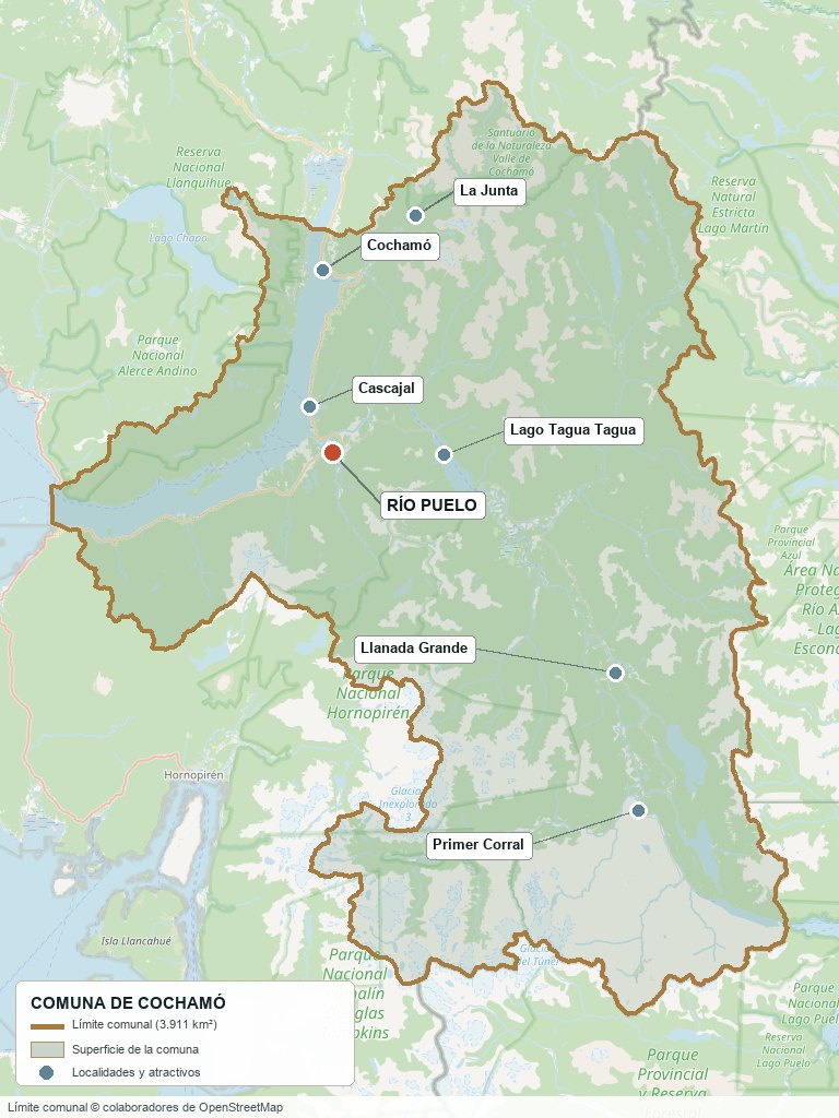
Commune boundary from OpenStreetMap open data
§ 03 Location, Geography and Territory View
Where Cochamó is, what it is built on and why its land matters.
3.1 Location
The commune capital is Río Puelo, at the southern head of the estuary; the town of Cochamó, which gives the commune its name, lies about 19 km to the north in a straight line. Travel guides give 112 km between Puerto Montt and Cochamó (1 hour 50 minutes by private transfer) and up to 116 km or more. From the town of Cochamó, Puerto Montt is about 52 km in a straight line, Puerto Varas about 60 and La Junta, in the Cochamó Valley, about 18; between Río Puelo and Llanada Grande there are about 37 km and to Segundo Corral, about 58.
Río Puelo, commune capital · 41°40′ S, 72°18′ W
3.2 Terrain and setting
Cochamó is a mountain commune with a fjord at its northwest end. According to our own grid of 485 points on a digital elevation model, elevation runs from 0 m (the estuary water) to 2,177 m, with a mean of about 860 m: 35.5 % of the grid lies between 1,000 and 1,500 m and 9.7 % above 1,500 m. The Yates volcano (2,187 m according to OpenStreetMap) rises above the estuary, and in the mountains there are peaks above 2,000 m, such as Aguja Sur (2,298 m), Torrecillas and Diente de Perro, all with elevations taken from OpenStreetMap tags, not official. The Cochamó, Puelo and Manso valleys were shaped by glaciers.
3.3 Hydrography
Main watercourses of the commune5 rows
| Watercourse | Role in the territory |
|---|---|
| Puelo River | Rises in Lake Puelo, in Argentina, runs about 120 km to the Reloncaví estuary and is, according to the Ministry of the Environment book (2022), the second highest-flow river in Chile. It forms Lake Inferior and Lake Tagua Tagua and receives the Manso. |
| Manso River | Tributary of the Puelo; it rises in Argentina. It is the axis of the valley where Paso El León and Valle El Frío are located. |
| Cochamó River | About 25 km, from granite slopes to the estuary beside the town. In 2009 a flow reserve was decreed for it, considered the country's first water reserve. |
| Lakes Tagua Tagua, Inferior, Totoral, Verde, Azul, Blanco and Vidal Gormaz | Lakes with their center inside the commune polygon. Tagua Tagua (about 9 km long) is crossed by barge to reach Llanada Grande; Azul and Vidal Gormaz have alerces. |
| Estuario de Reloncaví | Fjord at the northwest end of the commune. It concentrates the farming sites and the maritime destinations. |
3.4 Soils
No land-use capability study (CIREN) with commune-level figures was found. What sales listings and guides describe is a territory of native forest on the slopes, clearings and open pampas on the valley floors (for example, about 35 ha of pampa on a 206 ha farm at Lago Las Rocas) and terraces with views of the estuary. Native forest cover (evergreen, alerce, coihue, lenga) dominates over plantations.
- Advantage: valley floors and estuary terraces are the land with the best agricultural and residential use.
- Limitation: most of the commune is mountains and forest; on the slopes, any intervention in native forest requires a management plan (Law 20,283).
- Risk: no landslide susceptibility map or volcanic hazard map was found for the commune; the July 2026 frontal system cut roads and created landslide risk in the area.
- Real estate implication: the same property size can be a terrace with an easement and a view of the estuary or 917 ha of alerce at 1,100 m elevation with access only on foot: legal and physical access weigh more than area.
§ 04 Climate and Seasonality View
A mountain and fjord climate, with abundant rain in the valley and snow in the high valleys.
There are no 1991-2020 climate normals from a station inside the commune. The Dirección Meteorológica (Meteorological Directorate) has nearby stations (La Ensenada, Punta Huano, El Mirador and El Tepual), all outside the polygon, and only El Tepual has normals. The Dirección General de Aguas operates a weather station at Puelo and a stream-gauging station on the Puelo River, whose series were not consulted; one report cites a cumulative 792 mm between April and June 2023, a quarter and not an average.
Reference climate parameters (El Tepual, 1991-2020 normals)5 rows
| Parameter | Typical value | Comment |
|---|---|---|
| Mean annual temperature | 10.3 °C | January 14.3 °C and July 6.4 °C. |
| Mean minimum temperature | 6.2 °C | El Tepual is at 90 m and in the valley; the high valleys are colder. |
| Annual precipitation | 1,565.6 mm | June, 213.4 mm; February, 69.0 mm. A tourism source, using model data, mentions about 2,500 mm a year in the Cochamó Valley: it is only an order of magnitude. |
| Köppen classification | Several types | According to Wikipedia, from rainy temperate at the estuary to mountain tundra in the high mountains; not verified in the primary source. |
| Snow and frost | No official figure | There was an agricultural emergency due to heavy snowfalls in 2024, and in July 2026 the snow left livestock in isolated areas such as Paso El León without forage. |
Reference station: El Tepual (DMC), 1991-2020 normals, about 66 km from the town of Cochamó and at 90 m elevation. It is a picture of the central valley, not of the estuary or the mountains: in the Cochamó Valley a tourism source, using model data, mentions about 2,500 mm a year, and there is no station with published normals in the commune.
The El Tepual normals show a trend toward less rain: 1,844.7 mm in 1931-1960, 1,802.5 mm in 1961-1990, 1,615.4 mm in 1981-2010 and 1,565.6 mm in 1991-2020. Wind data were not verified.
§ 05 History: From the Alerceros to Conservation View
A territory of passage between the sea and the mountains, settled by alerceros, arrieros and a meatpacking company that did not last.
-
Before the 19th century
Huilliches, Poyas and Cuncos
According to the Municipality, the estuary was inhabited by Huilliches, Poyas and Cuncos. The Ministry of the Environment book speaks of more stable settlement about 1,200 years ago, and another book attributes to the Tehuelche pictographs near Lake Vidal Gormaz and the Torrentoso River.
-
Mid-19th century
The alerceros
The alerce draws camps that become hamlets. Cochamó is founded by families from the islands (Huar, Chiloé) and from Calbuco; the original founding date is not known exactly.
-
1884-1895
The explorers
Roberto Christie (1884) and Óscar Fischer (1894) explore the Cochamó Valley, and Hans Steffen (1895) goes up the Puelo valley to the Río Puelo pass, sailing Lake Inferior and Lake Puelo.
-
1901
Road to Argentina
The State opens the road via Los Morros, Lake Vidal Gormaz and El León, with a telegraph line from Puerto Montt to Argentine Patagonia.
-
1903-1914
The meatpacking company
Land is granted from the Cochamó River to the border to the Welshman Thomas Austin. The company that inherits it sets up a meatpacking plant, slaughterhouse, tallow works, sawmill and pier in the town; in 1906 the Ministry's book counts more than 300 inhabitants. In 1914 it abandons the territory for failing to meet its commitments to the State.
-
Until 1970
The arrieros
The arrieros take cattle to Osorno or Puerto Montt by land and by sea until the 1970s.
-
1976-1987
The road arrives
In 1976 work begins on the Ensenada–Ralún highway, with local labor from residents; between 1982 and 1985 it reaches the town of Cochamó and in 1987 Puelo.
-
1979
The commune is born
Decree Law 2868 creates the commune, separating it from Puerto Montt, and sets its current boundaries; according to Wikipedia, it transfers Ralún to Puerto Varas. The Municipality is created on 21 September and its first mayor, appointed, is Manuel García Oroz.
-
Late 1980s-2007
Salmon farming arrives
Salmon farming becomes the main activity of the estuary. The ISA virus closes many farms in 2007 and causes a labor crisis with migration to Puerto Montt and Aysén.
-
2009
First water reserve
A presidential decree declares the Cochamó River a flow reserve, the country's first water reserve.
-
2013
Arrieros recognized
The mountain arrieros of Paso El León are declared Living Human Treasures: it is the first time the region receives that recognition.
-
2014-2017
The power plant that never was
The Mediterráneo run-of-river plant (210 MW) receives its environmental approval in 2014. The Third Environmental Court annuls it in 2016 for lack of Indigenous consultation and the Supreme Court upholds that in 2017.
-
2015
Ash from Calbuco
After the eruption of the Calbuco volcano, on 30 April the wind carries ash toward Ralún, Cochamó and Reloncaví: the commune is left without drinking water and classes are suspended.
-
2021
Tourism interest zone
On 28 July the “Río Puelo, Cochamó y Hualaihué” Tourism Interest Zone (ZOIT) is declared. The previous one, from 2007, had been revoked in 2020.
-
2023
Cochamó Valley nature sanctuary
On 26 January the Council of Ministers for Sustainability approves the Cochamó Valley nature sanctuary, of more than 11,400 ha. According to the press, the decree was published in January 2024.
-
2025
ZOIT extension and purchase of Puchegüín
On 18 July the ZOIT is extended (decree published in the Diario Oficial on 30 July), and on 19 December the purchase of the Puchegüín estate (132,985 ha) closes to conserve it, with more than US$78 million raised in 21 countries.
§ 06 Cultural Identity and Indigenous Peoples View
A culture of arrieros, Chilotes and Calbucanos that looks to both sides of the Andes.
According to the 2024 Census, 18.2 % of the population identifies as belonging to an Indigenous people (764 people), below the regional average (26.6 %) and above the national average (11.4 %). The BCN report does not break down which people. It could not be verified how many Indigenous communities are registered with CONADI (National Indigenous Development Corporation); in the documentation reviewed, one community appears (Domingo Cayún Panicheo, which filed a complaint against the Mediterráneo plant) along with an organization of rural and Indigenous women.
The cultural strata of Cochamó5 rows
| Tier | Visible traces today |
|---|---|
| Huilliche, Poya and Cunco | Peoples that the Municipality cites in the estuary, and pictographs in the interior valleys that one book attributes to the Tehuelche. In the estuary there are applications for coastal marine spaces for Indigenous peoples (ECMPO), whose status was not verified. |
| Chilotes and Calbucanos | The families from Huar, Chiloé and Calbuco who founded the town out of the alerce loggers' camps. Their mark is in the curanto (traditional earth-oven feast), the minga (communal work party) done by hand over sea and land, and the tejueleros (shingle makers). |
| Arrieros and cross-border culture | The mountain arrieros of Paso El León (Living Human Treasures 2013), mate, gaucho dress, and schools and mills shared with Argentina. |
| The meatpacking company | The concession to the Welshman Thomas Austin (1903) and the meatpacking plant his company built in the town of Cochamó, where in 1906 the Ministry's book counts more than 300 inhabitants. |
| Recent arrivals | Foreign-born people were 2.0 % in 2017 and 2.6 % in 2024 (region 4.0 %, country 8.7 %). |
Local trades include leather and wood artisans, shingle makers, shipwrights in Pucheguín, weavers using the upright loom, ulmo-honey beekeepers, shellfish divers, and gatherers of wild fruit and morels in Llanada Grande.
§ 07 Key Demographic Data View
7.1 Population and growth
Comparative demographic indicators14 rows
| Indicator | Commune | Region | Country |
|---|---|---|---|
| Population, 2017 Census | 4,023 | — | 17,574,003 |
| Population, 2024 Census | 4,199 | 890,284 | 18,480,432 |
| Intercensal change | +4.4 % | +7.4 % | +5.2 % |
| Commune area | 3,910.8 km² | — | — |
| Population density (2024) | 1.07 inhabitants/km² | — | — |
| Rural population (2024) | 100 % | 29.0 % | 13.3 % |
| Foreign-born population (2024) | 2.6 % | 4.0 % | 8.7 % |
| Masculinity index (2024) | 111.4 | 96.5 | 94.3 |
| Older adult index (2024) | 141.1 | 75.8 | 79.0 |
| Indigenous population (2024) | 18.2 % | 26.6 % | 11.4 % |
| People with disabilities, aged 5 or older (2024) | 11.5 % | 11.0 % | 11.1 % |
| Average schooling (2024) | 8.8 years | 9.8 years | 10.4 years |
| Birth rate (2023, per thousand) | 6.31 | 9.06 | 8.73 |
| Overall mortality (2023, per thousand) | 9.8 | 6.9 | 6.1 |
7.2 Age structure (2024 Census)
Population distribution by age group5 rows
| Age group | Population 2024 | % Commune |
|---|---|---|
| 0 – 14 years | 587 | 14.0 % |
| 15 – 29 years | 645 | 15.4 % |
| 30 – 44 years | 867 | 20.6 % |
| 45 – 64 years | 1,272 | 30.3 % |
| 65 years and over | 828 | 19.7 % |
Cochamó is a very aged commune: its older adult index went from 96.6 in 2017 to 141.1 in 2024, and overall mortality (9.8 per thousand) exceeds the regional rate (6.9). The population grew 4.4 % between 2017 and 2024, somewhat less than the region, after falling between 2002 and 2017 (from about 4,532 to 4,023 inhabitants, according to INE estimates compiled by CityPopulation). There are 111 men for every 100 women, well above the region and the country.
In 2017 the census districts were Puelo (1,397 inhabitants), Cochamó (1,327), Segundo Corral (670), Yates (466) and Paso El León (159). Yates and Paso El León had more than 1.4 men for every woman. The INE does not publish population by locality on its website, so there are no 2024 figures for the town of Cochamó, Río Puelo or Llanada Grande. The 4,420 people enrolled in primary care exceed the census population: they probably include people who live outside the commune.
§ 08 Economic and Socioeconomic Data View
8.1 Poverty and social indicators (Casen 2024 and Registro Social de Hogares)
Social indicators compared5 rows
| Indicator | Commune | Region | Country |
|---|---|---|---|
| Income poverty, Casen 2024 | 22.5 % | 16.5 % | 17.3 % |
| Multidimensional poverty, Casen 2024 | 15.9 % | 16.3 % | 17.7 % |
| People in households lacking basic services (RSH, June 2026) | 55.4 % | 22.8 % | 12.9 % |
| Overcrowded households (RSH, June 2026) | 4.6 % | 7.1 % | 7.8 % |
| Population born outside the country, 2024 Census | 2.6 % | 4.0 % | 8.7 % |
Casen 2024 uses a new methodology and is not comparable with that of 2022 (10.8 % income poverty and 22.7 % multidimensional in the previous edition of the report): it cannot be concluded that anything rose or fell. The relative position is mixed: Cochamó's income poverty exceeds the regional and national figures, while its multidimensional poverty falls below both. But more than half of the people (55.4 %) live in households without complete basic services, more than four times the national average and more than double the regional one: this is consistent with a 100 % rural commune, with spring water, firewood and areas with no electrical grid.
8.2 Economic activity (SII) and municipal finances (SINIM)
Business structure and municipal finances11 rows
| Economic indicator (SII / SINIM) | Value |
|---|---|
| Registered businesses, 2024 | 475 (micro 341, small 48, medium 3, no sales or no information 83) |
| Lodging and food service businesses, 2024 | 119 (25.1 %); region 7.6 %; country 5.7 % |
| Agriculture, livestock, forestry and fishing businesses, 2024 | 75 (15.8 %); region 11.0 %; country 6.3 % |
| Retail and wholesale trade businesses, 2024 | 130 (27.4 %); region 27.7 % |
| Dependent workers, 2024 | 611: public administration 318 (52.0 %; region 5.9 %), lodging and food service 180 (29.5 %; region 4.2 %), agriculture 40 (6.5 %; region 19.0 %), trade 37 |
| Municipal revenue, 2025 | $4,323 million (≈ $1,029,000 per inhabitant) |
| Dependence on the Fondo Común Municipal (Municipal Common Fund), 2025 | 57.7 % of total revenue ($2,494 million); permanent own revenue $744.9 million |
| Aquaculture license fees (Law 20,033) | $212.1 million (2023), $152.0 million (2024), $193.0 million (2025): 25.9 % of permanent own revenue |
| Municipal business licenses, 2025 | $158.1 million; tourism business licenses: not reported |
| Property tax accruing to the municipality, 2025 | $284.8 million (+43 % compared with 2024; the cause was not verified) |
| Vehicle circulation permits, 2025 | $71.8 million |
More than half of the commune's formal employment is in the public sector (the Municipality, health and education), and almost a third in tourism. Agriculture, with 75 businesses, provides only 40 dependent jobs: family properties worked by their owners. The municipal budget per inhabitant is double that of Fresia, because of the weight of the Municipal Common Fund in small, isolated communes, which finances 57.7 % of revenue.
§ 09 The Productive Engine: Nature Tourism, Public Employment and the Salmon Estuary View
The value of Cochamó's land is explained by tourism, not agriculture.
9.1 Nature tourism
The Cochamó Valley, with granite walls that guides compare to Yosemite, has drawn climbers and hikers since the 2000s. The 2015-2016 season received more than 15,000 visitors and overwhelmed the infrastructure; since 2017, entry to the valley requires a camping reservation, made through an organization of landowners and friends of the valley, with access control and park rangers. The ZOIT “Río Puelo, Cochamó y Hualaihué” was declared on 28 July 2021 and extended on 18 July 2025; as of December 2024 there were 252 registered tourism services in that territory (Cochamó and Hualaihué together), 79 more than when it was declared.
A survey by Cochamó's tourism office (December 2023 to March 2024; 523 people, 64 of them foreign) showed that February is the peak month, that about 40 % travel as a couple, that almost a quarter do not stay overnight and that most arrive in their own vehicle, mainly from the Santiago Metropolitan Region (more than 20 %), Biobío, Los Lagos and Valparaíso.
Weight of tourism in Cochamó compared with the region and the country4 rows
| Indicator | Cochamó | Region | Country |
|---|---|---|---|
| Lodging and food service businesses as a share of total (SII, 2024) | 25.1 % | 7.6 % | 5.7 % |
| Dependent workers in lodging and food service as a share of total (SII, 2024) | 29.5 % | 4.2 % | 5.0 % |
| Dependent workers in public administration as a share of total (SII, 2024) | 52.0 % | 5.9 % | 7.0 % |
| Dependent workers in agriculture as a share of total (SII, 2024) | 6.5 % | 19.0 % | 8.2 % |
9.2 Salmon and mussel farming in the estuary
The Reloncaví estuary has salmon farming sites: the specific cases found are Costa Pucheguín and Pocoihuén, both in salmonid concession group number 1. In November 2023 a harmful algal bloom affected sites in that group, with mass mortalities at at least two; the press reports between 9 and 18 sites affected and between 914 and more than 1,500 tons of mortality, depending on the moment of the event. There are also maritime destinations for mussel seed collectors (Diario Oficial, the Official Gazette, of 18 April 2022). The total number of concessions and the commune's production could not be verified.
9.3 Livestock and family farming
According to the SAG (Agriculture and Livestock Service) animal traceability system (2020), the commune had 546 livestock holdings with 5,267 cattle, about 9.6 head per holding. Livestock is fragile: there was an agricultural emergency decree for heavy snowfalls in 2024, and in July 2026 the snow left livestock in isolated areas such as Paso El León without forage. In July 2025 INDAP (Agricultural Development Institute) opened a livestock technical grant call specific to Cochamó. No figures were found for transhumance, forestry or the 2021 Agricultural Census by commune.
9.4 Hydropower
The Mediterráneo run-of-river plant (210 MW) was going to draw water from the Puelo River or the Manso, with a 63 km high-voltage line that would cross the estuary. Its 2014 environmental approval was annulled by the Third Environmental Court in 2016 and the Supreme Court upheld that in 2017, for lack of Indigenous consultation. Its current status could not be verified: check the file in the SEIA (Environmental Impact Assessment System). It is a reminder that the Puelo and Manso basins have been the object of energy projects.
§ 10 Real Estate Market View
10.1 Available properties and property types
The supply is rural land, in 5,000 m² subdivisions facing the estuary, lots of 1 to 3 ha on the banks of the Puelo River and farms of tens of hectares in the interior valleys. On Yapo (queried on 16 November 2026) there are 52 unique listings in Cochamó; 39 have a usable price and area, 25 of them land without buildings. On Portal Inmobiliario there are 135 listings with usable area and on Chilepropiedades, 15. Produncan Lands markets six properties within the commune boundaries.
10.2 Average price by property type (indicative, November 2026)
Indicative price ranges by property type (asking prices on Yapo, land only; UF at $41,344)6 rows
| Property type | Indicative price range | Notes |
|---|---|---|
| Parcel of ~5,000 m² | Median 1,330 UF (≈ $55 MM); range 725-10,540 UF | 7 listings; about 2,560 UF/ha. With buildings, median of 1,935 UF (12 listings). |
| Lot of 0.65 to 3 ha | Median 2,696 UF (≈ $111.5 MM); range 1,329-4,354 UF | 10 listings; about 2,120 UF/ha. |
| Farm of 3 to 10 ha | Median 4,354 UF (≈ $180 MM); range 3,773-4,838 UF | 3 listings; about 880 UF/ha. |
| Farm of 10 to 50 ha | Median 6,192 UF (≈ $256 MM); range 3,628-13,902 UF | 3 listings; about 260 UF/ha (194-306). |
| Farm of more than 50 ha | Between 8,466 UF (56 ha) and 26,616 UF (917 ha) | 2 listings; 151 and 29 UF/ha. |
| Parcels by sector | Between 725 and 10,540 UF | Estuary coast: 725-4,838 UF. Puelo River bank: 1,330-10,540 UF. Llanada Grande and Segundo Corral: 3,628-6,192 UF. |
These are asking prices, not closing prices. Of the 39 usable Yapo listings, 18 were updated in the last 90 days; the market turns over little and there are only seven parcels of 5,000 m² without buildings. Adding the portals, the median for the ~5,000 m² parcel rises to about 2,700 UF, because houses and cabins are also included there.
In the same query, Cochamó is worth about twice what Hualaihué (665 UF), Los Muermos (605 UF) and Fresia (532-605 UF) are, and between 0.6 and 0.7 times Puerto Varas (2,177 UF, in a non-random sample of 160 of 530 listings). The differential seems to reflect tourist appeal more than infrastructure, although the cause was not measured. A 206 ha farm at Lago Las Rocas fell from 46,848 to 27,000 UF in four months (−42 %), and nationwide requests to subdivide rural properties fell 62.4 % in the first half of 2025 compared with 2022 (Diario Financiero).
10.3 What determines price in Cochamó
Valuation factors in this market, ordered by available local evidence6 rows
| Factor | Price impact | How to check it here |
|---|---|---|
| Puelo River bank with access | 5,000 m² from 1,330 to 10,540 UF, an eightfold spread | Check the boundary with the river and the access easement; the most expensive listing is a parcel on the banks of the Puelo River. |
| Vehicle, foot or barge access | An estate of 917 ha with access on foot: about 29 UF/ha; farms of 10 to 50 ha: about 260 UF/ha | Ask for a public road, a registered easement or confirmation that access is by the Tagua Tagua barge, of which there is only one and which is sometimes out of service. |
| Estuary view and proximity to town | 725 to 4,838 UF on the estuary coast | Look at the property facing the maritime concessions: it may end up facing an aquaculture concession. |
| Approved subdivision, individual tax ID (rol propio) and titles | No measured differential | In Llanada Grande there are “acciones y derechos” (undivided shares) listings that are not a registered lot. Require a rol propio and an SAG certificate. |
| Own energy and water | No measured differential | Many lots offer “feasibility” rather than a connection; in the interior valleys, assume a solar panel, turbine or generator. |
| Proximity to the border | No measured differential | Properties near Segundo Corral, Las Rocas and Paso El León may be in a border zone (DL 1,939); consult the Dirección de Fronteras y Límites (Directorate of Borders and Boundaries). |
§ 11 Territorial Planning in Cochamó View
Cochamó has no zoning plan and no urban boundary: the whole commune is rural land.
Cochamó has no commune zoning plan in force. The BCN report, with SINIM data, records “No” between 2023 and 2025; the urban boundary mapping of MINVU (Ministry of Housing and Urban Planning) has no polygon for Cochamó, Puelo or Ralún, and the 2024 Census classifies the commune as 100 % rural. A 2019 ordinance mentions a “zoning plan project” for the locality of Cochamó, whose status could not be verified. Consequently, all subdivision and construction is governed by DL 3,516 and article 55 of the LGUC (General Law of Urban Planning and Construction); the town of Cochamó, Río Puelo and Llanada Grande have no zoning, building standards or regulated risk areas.
Planning instruments that affect the commune5 rows
| Instrument | What it regulates | Status |
|---|---|---|
| Communal zoning plan | Zones, uses and building standards in urban areas. | None in force, and no urban boundary in MINVU's mapping. |
| PLADECO | Commune development plan; it does not regulate land use. | In force; last formulated in 2023, according to SINIM. |
| Plan Regulador Intercomunal de Llanquihue (intercommunal zoning plan) | Lake Llanquihue basin: Puerto Octay, Frutillar, Llanquihue, Puerto Varas, Puerto Montt, Calbuco, Maullín and Los Muermos. | Started on 11 August 2026. Cochamó is not in the study area; Puerto Varas is, and it could reach Ralún and Petrohué. |
| ZOIT “Río Puelo, Cochamó y Hualaihué” | Tourism planning for part of both communes; it does not change land use by itself. | Declared on 28 July 2021; extended on 18 July 2025. |
| Cochamó River flow reserve | Water reserve by presidential decree. | Decreed in 2009. |
The protected areas with territory in the commune are: the Cochamó Valley Nature Sanctuary (more than 11,400 ha, approved on 26 January 2023, almost all state-owned with three private properties, 100 % inside the commune polygon); the Tagua Tagua Park, private, also inside; the Hornopirén National Park, whose 2018 expansion places it in the communes of Cochamó and Hualaihué (according to our own calculation on OpenStreetMap, 45 % of its area falls inside Cochamó); the Alerce Andino National Park (27 %, although its decree places it in Puerto Montt) and a small part of Pumalín. Vicente Pérez Rosales National Park is not in Cochamó. The Puchegüín estate (132,985 ha, a third of the commune) is owned by a foundation and is not yet an official protected area; its planned model is at least 80 % strict conservation and up to 20 % sustainable uses.
No tsunami flood map was found for the estuary: the 2024 SHOA (Navy Hydrographic and Oceanographic Service) listing does not include Cochamó, although the settlements of Cochamó, Pucheguín, Sotomó and Puelo are at sea level. No landslide susceptibility map or volcanic hazard map was found either (Yates, Hornopirén, Calbuco, Osorno): their absence does not mean the hazard does not exist.
§ 12 Neighbourhoods and Areas View
Cochamó is not organized into neighborhoods but into four territories separated by geography: the estuary, the Cochamó Valley, the Puelo valley and the Manso valley. In 2017 the five census districts were Puelo, Cochamó, Segundo Corral, Yates and Paso El León; the INE does not publish 2024 population by locality.
Areas of the commune and their profile6 rows
| Sector | Features | Market profile |
|---|---|---|
| Río Puelo (capital) | Southern head of the estuary. About 800 inhabitants according to a tourist guide (the census district had 1,397 in 2017). It has a CESFAM, a gas station, Caja Vecina, a police station, a fire department and an airfield; there is no ATM. The turnoff to Lake Tagua Tagua starts here. | Parcels and 1 ha lots; 5,200 m² lots at 1,330 UF; the riverbank is the most expensive. |
| Town of Cochamó | About 19 km from Río Puelo. Inmaculada Concepción church (1901 or 1917 depending on the source), school, rural health post and the gateway to the Cochamó Valley. | Terraces with estuary views and seaside land. |
| Estuary coast (Cascajal, Sotomó, Yates, Llaguepe, Pucheguín, Pocoihuén) | Hamlets with farming sites, rural health posts and hot springs. Sotomó can only be reached by boat and was, according to CNN Chile, the first place in Latin America with Starlink (2021). | 5,000 m² parcels from 725 UF and 1.5 ha lots with estuary views up to 3,870 UF. |
| Cochamó Valley and La Junta | Granite valley with no road: reached on foot or on horseback (4 to 6 hours to La Junta). Reservations mandatory. | The sanctuary is almost all state-owned, with three private properties. |
| Llanada Grande, Primer Corral and Segundo Corral | Upper Puelo valley: access via the Tagua Tagua barge and about 2 hours of gravel road. A health post with a paramedic in Segundo Corral. | Farms of 14 to 45 ha at 194-306 UF/ha; lots of 4 to 4.4 ha at 3,773-4,354 UF; “acciones y derechos” listings. |
| Paso El León and the Manso valley | Border valley with arrieros and a police outpost (retén). Access by gravel road, on horseback or by boat. No electrical grid verified. | Small farms; border-zone risk. |
§ 13 Basic Services, Utilities and Digital Connectivity View
Practical information that rarely appears in descriptions of a commune but that nonetheless determines whether any property is viable.
Utility providers and service coverage5 rows
| Service | Provider / operator | Practical notes |
|---|---|---|
| Electricity | Cochamó medium-sized system, run by SAGESA (Saesa Group) | It is an isolated system, with 5.88 MW of installed capacity (25 % hydroelectric and 75 % diesel); in 2020 92 % of the energy generated was hydroelectric, so it depends on rainfall. A CNE (National Energy Commission) summary indicates that it supplies mainly the estuary, Cochamó and Río Puelo (not confirmed in the report); in 2019 the regional Energy Seremi said that more than 500 people (~15 %) had no connection. The interior valleys use solar panels or generators. |
| Drinking water | APR committees and cooperatives | No list of APR (rural drinking water systems) was found; ESSAL does not appear to operate in the commune. In Llanada Grande there is a study to install an APR, with no verified status. The water dialogue (2023) speaks of a lack of sanitary authorization in several APR. |
| Sewerage | There is no rural network | There is no collection or treatment of wastewater in rural areas; septic tanks and individual solutions are used. Residents allege that a salmon company discharges wastewater into the sea. |
| Internet and phone | Mobile and satellite operators | Subtel (Undersecretariat of Telecommunications) funded mobile coverage through a public tender in Llanada Grande, the two Corrales, Las Rocas, Ventisquero, Paso El León, Valle El Frío, Las Rosas and Tagua Tagua–El Manso. There is no free-to-air television. The trunk fiber has an access point in Cochamó, but it does not reach homes. There is no signal in La Junta. |
| Household waste | Final disposal at the La Laja landfill (Puerto Varas) | The landfill serves nine communes and in October 2026 the Puerto Varas city council halted the expansion; without works, there would be no disposal site from August 2027. The later outcome was not verified. The water dialogue names garbage as the commune's second biggest problem. |
§ 14 Health View
Cochamó has no hospital: the network consists of a CESFAM, a rural emergency service and eight health posts, and everything else is two hours away.
The commune belongs to the network of the Servicio de Salud Reloncaví (Reloncaví Health Service). According to the BCN report (July 2026), it has ten facilities: one CESFAM, one rural emergency service and eight rural health posts; there is no hospital. Validated enrollees in primary care total 4,420 (December 2025), more than the census population.
The commune's health network3 rows
| Facility | Type | Detail |
|---|---|---|
| Puelo CESFAM (Cochamó) | Family health center | Municipal administration with agreements with the Reloncaví Health Service; one directory places it in Cochamó and another source calls it “CESFAM Río Puelo–Cochamó.” Services and staffing were not verified. |
| Rural Emergency Service | Rural emergency service | Counts as one facility in the BCN report; its location was not verified. |
| Health posts at Cochamó, Llaguepe, Llanada Grande, Paso El Bolsón (Segundo Corral), Paso El León, Pocoihuén, Sotomó and Valle El Frío | Rural health posts | Eight health posts according to the public directory. In Segundo Corral, a paramedic serves about 250 people, most of them older adults. Medical rounds per post could not be verified. |
Isolation shows in extreme cases. In May 2023, a 74-year-old man with appendicitis was evacuated from the Paso El León police outpost on horseback, by quad bike and by boat down the Manso River to the border, and reached the hospital in El Bolsón (Argentina) the next day: air transport was ruled out because there was no night flight. It is a case from the Manso valley and does not represent the whole territory. No maritime ambulance or hospital boat was found for the commune; a SAMU base was not verified.
§ 15 Education View
15.1 School education
In 2025 the commune had 580 students (625 in 2023, −7.2 %) and 11 schools, all municipal; it does not belong to the Servicio Local de Educación Pública Llanquihue (Llanquihue Local Public Education Service). The names of six of the eleven schools, the boarding facilities and the existence of a high school could not be verified, although the Grade 10 (II medio) SIMCE indicates that at least one offers secondary education.
Schools with published enrollment (Subtel school connectivity program; the enrollment year is not given)5 rows
| Facility | Type | Distinction |
|---|---|---|
| Escuela Rural Río Puelo | Municipal | 287 students; the largest in the commune. |
| Escuela Básica Fronteriza Juan Soler Manfredini | Municipal | 189 students; in the town of Cochamó. |
| Escuela Rural Capitán de Bandada Carlos Rodríguez París | Municipal | 63 students; location not verified. |
| Escuela Rural San Antonio | Municipal | 32 students; location not verified. |
| Escuela Rural Soberanía | Municipal | 1 student; nearly closed. |
SIMCE 2025 results (preliminary)7 rows
| SIMCE test | Commune | Region | Country |
|---|---|---|---|
| Grade 4, reading | 257 | 275 | 276 |
| Grade 4, mathematics | 243 | 259 | 262 |
| Grade 8, reading | 216 | 236 | 238 |
| Grade 8, mathematics | 237 | 255 | 258 |
| Grade 8, history | 231 | 247 | 250 |
| Grade 10 (II medio), reading | 221 | 245 | 250 |
| Grade 10 (II medio), mathematics | 243 | 255 | 263 |
Cochamó falls below the region and the country at all levels and tests. The largest gaps are in Grade 10 (II medio) reading (24 points below the region) and Grade 8 reading (20 points). The average schooling of adults, 8.8 years versus 9.8 in the region, points the same way. With an enrollment of 580 students spread across eleven schools, most schools are very small.
15.2 Higher education
No university campus, professional institute or technical training center was found in the commune. The nearest options are Puerto Montt, Puerto Varas and Llanquihue, where the CFT Estatal de Los Lagos (State Technical Training Center) is located. There are public libraries in Cochamó (No. 371) and in Río Puelo (No. 224), according to Wikipedia.
§ 16 Reloncaví Estuary, Granite Valleys and Lakes View
Cochamó's natural setting is its reason for being: a fjord, three glacial valleys, a river that descends from Argentina, lakes with alerces and roadless mountains. It is a commune where the most valuable places to visit lie far from the road and are reached by barge, on horseback or on foot.
Natural attractions (straight-line distances from the town of Cochamó, unless noted)6 rows
| Attraction | Approx. distance | Activities |
|---|---|---|
| Cochamó Valley and La Junta | 18 km | Climbing on granite walls, trekking and camping; access only on foot or on horseback, with mandatory reservation. Part of the nature sanctuary. |
| Estuario de Reloncaví | In town | Viewpoints over the fjord and the Yates volcano, birdwatching, dolphins and sea lions, fishing and boating at Llaguepe. |
| Sotomó and Del Sol hot springs | About 20 km | Hot springs on the estuary coast; Sotomó can only be reached by boat. |
| Lake Tagua Tagua and Tagua Tagua Park | 42 km to Punta Canelo, plus the barge | Barge crossing of about 45 minutes between Punta Canelo and Punta Maldonado; private conservation park. |
| Puelo River and upper Puelo valley | 19 km to Río Puelo; about 37 km more to Llanada Grande | Fly fishing, rafting, El Salto waterfall, lakes Azul, Vidal Gormaz and Totoral with alerces, Primer Corral footbridge. |
| Manso valley and Paso El León | On horseback or by boat | Arrieros, pictographs near the international pass and views of the mountains; border with Argentina. |
Reloncaví estuary, Cochamó and Puelo valleys, Lake Tagua Tagua
On protected areas, see section 11: the Cochamó Valley nature sanctuary, Tagua Tagua Park and parts of the Hornopirén and Alerce Andino national parks are inside the commune polygon. The “Bosques Templados Lluviosos de los Andes Australes” (Temperate Rainforests of the Southern Andes) biosphere reserve covers the area. The Puchegüín estate is private and for conservation, but is not yet an official protected area.
§ 17 Connectivity and Transportation View
17.1 Road network
The Carretera Austral (Route 7) does not cross Cochamó: it passes through La Arena and Hornopirén, in Hualaihué. The commune is traveled via Route V-69, 113 km between Ensenada and Caleta Puelche, of which 64 km are paved and 49 km are gravel (Vialidad, the Roads Directorate, March 2026). The first 50 kilometers, from Ensenada to the Cochamó bridge, are paved, and include Ralún, which belongs to Puerto Varas.
Route V-69 by section (Vialidad, 18 March 2026)5 rows
| Section | Status |
|---|---|
| Ensenada to Cochamó (km 0 to 50) | Paved, in good condition. |
| Cochamó bridge to Pucheguín bridge (about 9 km) | Under construction: 70 % complete, contract ends 31 January 2027; five permanent bridges. Rockfalls reported by regional councilors. |
| Pucheguín bridge to Cascajal Bridge No. 3 | 12.35 km of gravel; unfunded, included in the Plan Zona Extrema 2.0 (Extreme Zone Plan 2.0) if approved. |
| Puelo sector (km 71 to 87) | Paved in 2012. |
| Km 87 to 113, to Caleta Puelche | Engineering study 78 % complete; narrow section, no paving scheduled. |
Reference distances5 rows
| Route / destination | Distance and details |
|---|---|
| Puerto Montt | 112 km and 1 hour 50 minutes by private transfer; other guides give 116 km and about 2 hours. There is no single official figure. |
| Puerto Varas | About 91 km via Route 225 and the V-69; by bus, 1 hour 40 minutes according to one source. |
| El Tepual Airport | The distance and travel time by road to Cochamó were not verified; the inference is that it would be similar to that of Puerto Montt. |
| Llanada Grande | From Río Puelo, take the turnoff to Lake Tagua Tagua up to the Punta Canelo pier (42 km from the town of Cochamó, about 60 minutes); then a barge of about 45 minutes and about 2 hours of gravel road. Between Río Puelo and Llanada Grande there are about 37 km in a straight line (one guide gives 32 km by road). |
| Caleta Puelche and the Carretera Austral | Via the V-69 to Caleta Puelche and from there the ferry to Caleta La Arena (Route 7); the status of the service was not verified. |
Between Puerto Montt, the Reloncaví estuary and the border
17.2 El Tepual Airport
Puerto Montt's airport, El Tepual, is in the commune of Puerto Montt, about 16 km from the center of that city. It is the arrival airport for people coming from other regions; no direct travel time to Cochamó was found.
Airport terminal fact sheet4 rows
| Fact | Detail |
|---|---|
| Commune | Puerto Montt (not part of Cochamó) |
| Distance from Cochamó | Not verified by road; Puerto Montt is 112 km away |
| Weather station | DMC code 410005; serves as a climate reference (outside the commune) |
| Airfield in the commune | Río Puelo has an airfield, according to a tourist guide; its characteristics were not verified |
17.3 Ground transport, barges and borders
- Buses: about four buses a day between Puerto Montt and Cochamó or Río Puelo, taking 2.5 to 3.5 hours (more in high season), run by Buses Estuario Reloncaví, Buses Río Puelo and Transhar; tickets are not sold online and schedules change. In Puerto Varas they stop on the main avenue.
- Tagua Tagua barge: it is state-owned, operated by Empresa Naviera Puelche, and is the only connection to Llanada Grande and the Corrales; in 2022 the “Don Felipe,” of smaller capacity, replaced the “Caupolicán” for 70 days. A 2023 note mentioned about $7,000 to $8,000 per vehicle, probably out of date.
- Borders: the Río Puelo (or El Bolsón) and El León passes are in the commune. The latest information found (2022) is that they were open from 08:00 to 20:00 only for humanitarian reasons, officials and local residents; the current status was not verified. The Army is building a road toward the Río Puelo pass, whose current progress was not verified.
§ 18 Tourism: Development, Attractions and Things to Do View
18.1 Tourism development
Tourism is the commune's engine, and the ZOIT “Río Puelo, Cochamó y Hualaihué” has organized its planning since 2021. The 2020 application file ranked as national-level attractions the Cochamó Valley, the Puelo River valley, the Puelo valley at Segundo Corral and Hornopirén National Park; as regional-level, Lake Tagua Tagua, the Yates volcano and the Sotomó hot springs. No current Tourism Development Plan or Cochamó Municipal Culture Plan was found.
18.2 Tourist attractions in the commune
- Cochamó Valley and La Junta: granite walls that guides compare to Yosemite; according to an unofficial local website, the first climbing route was opened in 1997. Entry requires a reservation.
- Reloncaví estuary: the areas of El Bosque, La Lobada, Pucheguín and Cascajal have the best views, with the Yates volcano above the fjord.
- Río Puelo and Llanada Grande: fly fishing on the Puelo and the Manso, lakes with alerces and the El Salto waterfall.
- Inmaculada Concepción Church of Cochamó: built in 1901 or 1917, depending on the source.
- Sotomó and Del Sol hot springs: on the estuary coast.
18.3 Museums and culture
No museum was found in the commune. There is a tourism office on the Río Puelo plaza and public libraries in Cochamó and Río Puelo. The Community Culinary Atlas (Atlas culinario comunitario, Centro de Patrimonio UC, 2014) and the Taller Laboral FAARTE, a workshop of women who work wool, are part of the intangible heritage.
18.4 Food and dining
The table blends estuary, countryside and forest. The Antología Gastronómica de la Patagonia Verde (Green Patagonia Gastronomic Anthology) calls the commune “a true pantry”: murta (Chilean guava), honey, hazelnuts, calafate and morels, as well as salmon cancato, fish and shellfish stews, and smoked foods.
- Curanto and pulmay: the Chilote tradition, alongside hen cazuela with dough noodles and asado parado (upright-spit roast).
- Ulmo honey and apple chicha: lagrimilla is the last drops of the apple chicha; mella is a sprouted-wheat flour.
- Morels and wild fruit: in empanadas, ceviches and sauces, gathered in Llanada Grande.
18.5 Nature and the outdoors nearby
- Fly fishing on the Puelo and Manso rivers, and outings along the old arrieros' trails.
- Camping and refuges: OpenStreetMap records more than 25 within the commune; their current status was not verified.
- Season: the Cochamó Valley is visited from mid-September to late April.
18.6 Calendar of events and traditions
Main milestones of the year (dates from a tourist guide, year not verified)8 rows
| Period | Event | Character |
|---|---|---|
| January | Potato and lamb festival; cancato on Marimeli Island | Traditional festivals: the potato and lamb festival, in the second week of January, and the cancato, in January (according to the guide). |
| 25-26 January | Arrieros gathering | In Valle El Frío. |
| First week of February | Minga and mussel festival | In Pueblo Hundido; the minga is the moving of a house over sea and land. |
| 2-3 February | Aduanas del Manso festival | Border festival. |
| Second week of February | Llanada Grande Week | Traditional festival of the Puelo valley. |
| 22-23 February | Corrales Week | Festival of Primer and Segundo Corral. |
| Late September | Commune anniversary | The Municipality was created on 21 September 1979; in 2026 it celebrated with 47 cuecas in a row. |
| 8 December | Chilean-Argentine fellowship gathering | In Paso El León. |
§ 19 Everyday Life, Sport and Practical Information View
What anyone who is going to live in Cochamó, not just visit it, needs to know.
19.1 Sport and identity
- Climbing and trekking: the Cochamó Valley has been a destination for climbers since 1997.
- Traditional games: truco, tejo, trompo (spinning top), sortija (ring game) and mounted musical chairs, along with mingas.
19.2 Shopping and supplies
Río Puelo has a gas station, Caja Vecina (rural banking services), a mechanic and cell phone service, but there is no ATM: bring cash. For what is missing — supermarket, pharmacy, hospital, higher education — the reference cities are Puerto Montt and Puerto Varas, two hours or more away.
19.3 Where to handle paperwork
Services based in Cochamó5 rows
| Office | Address or contact | Remarks |
|---|---|---|
| Municipality of Cochamó | Commune capital: Río Puelo; website municochamo.cl | The exact address of the headquarters was not verified. |
| CESFAM | Río Puelo | Primary care for the commune; see section 14. |
| Public Library No. 224 | Río Puelo | There is another, No. 371, in the town of Cochamó. |
| Tourism office | Río Puelo plaza | Visitor information; it collects the demand survey. |
| Carabineros (national police), fire department and airfield | Río Puelo | According to a tourist guide; whether still current was not verified. |
19.4 Cost of living and practical considerations
- Bring cash: there is no ATM and the Tagua Tagua barge is paid for in cash.
- In the interior valleys, electricity is usually solar or from a generator; in 2019 the then mayor spoke of about $100,000 a month for three hours of generator electricity.
- For more complex paperwork, higher education and large purchases, the cost and time of the trip to Puerto Montt must be assumed.
§ 20 Territorial Analysis: Strengths, Challenges and Opportunities View
An honest reading of the territory. A sound investment decision also requires knowing what doesn't work.
- A recognized nature destination: ZOIT since 2021 (extended in 2025), 252 registered tourism services and lodging and food service making up 25.1 % of businesses (region 7.6 %).
- An environment with private and public protection: the Cochamó Valley sanctuary (11,400 ha) and the Puchegüín estate (132,985 ha), a third of the commune.
- Prices that reflect that demand: the ~5,000 m² parcel with no buildings has a median of 1,330 UF, double that in Los Muermos and Fresia.
- Municipal revenue with its own source: aquaculture license fees were 25.9 % of permanent own revenue in 2025.
- Isolation: the V-69 has unfunded gravel sections and the interior valleys depend on a single barge.
- 55.4 % of people live in households without complete basic services (region 22.8 %), and a share of households have no electrical grid.
- A very aged commune: 141.1 older adults per 100 children, and 8.8 years of schooling.
- No hospital and SIMCE results below the region at all levels; 52 % of formal employment is public.
- No zoning plan or urban boundary, and outside the Llanquihue intercommunal plan.
- Paving the V-69 between the Cochamó and Pucheguín bridges (contract until January 2027) would bring the estuary closer to Puerto Montt.
- The ZOIT and the management of the Puchegüín estate open room to organize tourism and spread the pressure on the Cochamó Valley.
- A market that is adjusting: a 206 ha farm fell 42 % in four months and rural subdivisions nationwide fell 62.4 % between 2022 and 2025.
- The new Puerto Varas Hospital (start of operations expected for 2028) has Cochamó in its area of influence.
- Estuary: harmful algal blooms (2023), salmon mortalities and farming sites in front of properties with views.
- Border: DL 1,939 of 1977 and purchases of properties by foreigners at Lago Las Rocas and Paso El León, denounced by the mayor in 2026.
- Heavy snowfalls, isolation and closures of the V-69 or of the barge, with landslide risk in winter.
- Titles and boundaries: acciones y derechos, title regularization under DL 2,695, bordering state-owned land.
- La Laja landfill: without expansion, the nine communes that use it would be left with no disposal site from August 2027.
- Hydropower projects like Mediterráneo, whose current status is not verified.
Cochamó: Territory, Connectivity and Opportunities
Cochamó today is a territory of nature and difficult access: land that trades at double the price of Los Muermos, Fresia and Hualaihué, with no zoning plan, with a third of its area devoted to conservation and with a road that is being paved in stages. The opportunity exists for those who buy informed: legal access in writing, rol propio and subdivision certificate, their own well and power, and a visit in winter.
At Produncan Lands we know this territory and its opportunities. Our work is to connect properties with people looking to invest, live and develop new projects in southern Chile, offering our experience, local knowledge and commercial reach.
We invite you to get to know our properties in Cochamó and across southern Chile, and to entrust Produncan Lands with the sale of your property.
View properties at Produncan Lands§ 22 Sources and Methodology Note View
22.1 Sources consulted
Documents and sources used12 rows
22.2 Methodology note and data currency
- Casen 2024 uses a new methodology: its poverty figures are not comparable with those of Casen 2022. SIMCE 2025 is preliminary. The figures from the BCN Commune Report were checked against the official page on 16 November 2026.
- Ralún, which is often associated with Cochamó, belongs to Puerto Varas: the INE records it as a census district of that commune, and the data in this guide do not include it. The legal instrument that sets the 1979 boundary could not be read.
- Left out because they could not be verified: the commune's own climate normals, 2024 population by locality, the APR list, CIREN land-use capability, the total number of aquaculture concessions, transhumance and forestry data, the 2021 Agricultural Census by commune, the current status of the Mediterráneo plant and registered Indigenous communities.
- The surface areas of protected areas inside the commune polygon, elevation and straight-line distances are our own calculations (elevation, on a digital elevation model of about 90 m resolution); road distances are references from guides, not official figures. The area of the OpenStreetMap polygon (4,048 km²) differs from the official one (3,910.8 km²).
- Festival dates come from a tourist guide with no verified year; the schedules of the barges and of the border crossings could not be confirmed for 2026.
- The price ranges for the real estate market are indicative and do not constitute an appraisal: they are asking prices from listings, there are few listings of land without buildings, and some listings labeled “Cochamó” correspond to neighboring communes. Each property must be evaluated individually.
- This document does not constitute legal or tax advice.
- Closing date of this edition: November 2026. It is recommended to review the indicators in sections 7, 8 and 10 every year, along with the progress of the V-69 paving (section 17).
Territorial reference document prepared by Produncan Lands. It brings together official information (INE, BCN, SII, SINIM, MINEDUC, DMC, MINSAL) with local market knowledge, so that anyone — neighbor, visitor, investor or buyer — can understand Cochamó in depth before making a decision.