
CoyhaiqueAysén's Pentagonal City
History, Nature and Investment Opportunities in the Capital of Aysén
WHERE THE SIMPSON MEETS THE COYHAIQUE
Before it was a city, it was a corral on the plain: paddocks at the confluence of the Simpson and Coyhaique rivers where the drovers of the Sociedad Industrial de Aysén let their livestock rest. In 1928 surveyors laid out a five-sided plaza on top of it, and five councilmen lent their surnames to the five streets that surround it.
The city grew toward the hills without losing the habit of looking out at the countryside. Above lies the lenga and ñire forest; to the east, the coirón and neneo steppe that stretches toward Argentina; below, the valley, where Cerro Mackay casts its afternoon shadow over the rooftops.
Here winter smells of woodsmoke, and frost whitens the paddocks until midday. A monument to the shepherd, dating from 1944, recalls what the city once lived on, and the road south continues along the Carretera Austral to Villa O'Higgins, 557 kilometers away.
Version 1.0 · Expanded edition · September 2026
The Commune at a Glance
The key facts about Coyhaique at a glance. Each figure is explored in the corresponding section.
Administrative identification and reference data11 rows
| Fact | Detail |
|---|---|
| Official name | Coyhaique Commune (also spelled Coihaique) |
| Region / Province | Aysén del General Carlos Ibáñez del Campo Region · Coyhaique Province |
| Demonym | Coyhaiquino / coyhaiquina |
| Civic center coordinates | 45°34′ S · 72°04′ W (Plaza de Armas) |
| Area | 7,290.2 km² (BCN, 2025) |
| Elevation | ≈ 300 m a.s.l. in the city; 525 m in Balmaceda |
| Dialing code | +56 67 |
| City climate | Cold temperate, semi-continental (Cfb/Dfb), DMC 1991–2020 climate normals |
| City anniversary | October 12 (1929) |
| Commune established | Law 8,750 of 1947, in force since July 1 of that year |
| Municipality | Municipality of Coyhaique · Mayor Carlos Gatica Villegas · 6 council members (BCN, 2025) |
Overview
Coyhaique is the capital of the Aysén Region and its only urban center of any size: 57,823 inhabitants according to the 2024 Census, 57 % of the region's total of 100,745. It sits at an elevation of about 300 meters, at the confluence of the Simpson and Coyhaique rivers, east of the Andes, within a commune of 7,290 km² of lenga forest, steppe, lakes and mountain ranges. In the 2017 Census, 86 out of every 100 residents lived in the urban area.
Its role in the territory is that of administrative hub and gateway. It is home to the Regional Government, the Court of Appeals, the Regional Hospital, the Universidad de Aysén and 70 % of all public-sector employees in the entire region (SII, 2023). Balmaceda airfield, 57 km away, connects the region with Santiago and Puerto Montt, and the Carretera Austral passes through the city on its way south.
The contrast with its neighbor Puerto Aysén, 65 km to the west, defines the character of both. Puerto Aysén was the capital of the Territory until 1974 and is a port town; Coyhaique was born on a cattle estancia, faces the steppe and ended up with the machinery of the State. That difference explains almost everything that follows: an economy built on public salaries rather than exports, a city that grew quickly and has now stopped growing, and air that winter and woodsmoke make hard to breathe.
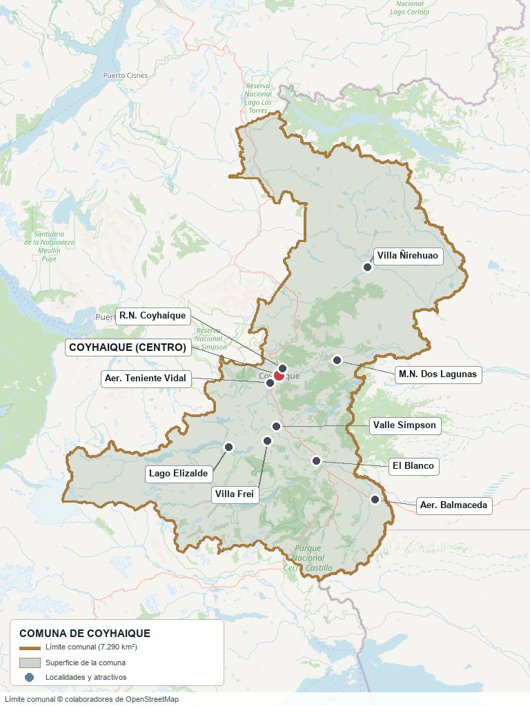
Communal boundary based on OpenStreetMap open data
§ 03 Location, Geography and Territory View
Where Coyhaique is, what it is built on, and what the landscape says about what can be done with its land.
3.1 Location
The commune measures about 145 km from north to south and 125 km from east to west (measured on its official boundary in OpenStreetMap). It stretches from the Ñirehuao valley in the north to Balmaceda in the southeast, and from the foothills around Lago Elizalde to the border with Argentina. By road, the city is 65 km from Puerto Aysén, 57 km from Balmaceda, 96 km from Villa Cerro Castillo and 557 km from Villa O'Higgins, the end of the Carretera Austral.
Plaza de Armas · 45°34′ S 72°04′ W
3.2 Terrain and setting
The commune lies within the Patagonian cordillera unit of fjords and tectonically controlled rivers. The city occupies the floor of a valley hemmed in by hills, with Cerro Mackay on one side. This has a practical consequence: on winter nights the cold air stays trapped at the bottom (thermal inversion), which is what aggravates the air-quality problem described in section 11. To the east, the terrain descends to the steppe and the climate becomes drier.
3.3 Hydrography
Main bodies of water in the commune5 rows
| Watercourse | Role in the territory |
|---|---|
| Río Simpson | It joins the Coyhaique in the city center and flows down toward Puerto Aysén. Its valley carries the paved highway and the Reserva Nacional Río Simpson (40,452 ha). |
| Río Coyhaique | It crosses the city; at its confluence with the Simpson, the Sociedad Industrial de Aysén built its estancia in 1906. |
| Lago Elizalde | 36 km away by road; part of the lake sectors of the Parque Nacional Cerro Castillo. |
| Lagos Frío and Atravesado | 23 and 39 km from the city. Edelaysén operates a hydroelectric plant on Lago Atravesado. |
| Río Ñirehuao | A valley in the north of the commune, part of the original concession of the Sociedad Industrial de Aysén (Coyhaique, Mañihuales and Ñirehuao). |
3.4 Soils and vegetation
The Ministry of the Environment describes the commune's ecosystems as deciduous lenga forest, ñire scrubland and coirón and neneo steppe (the latter classified as vulnerable). Their distribution follows the rainfall gradient: about 1,100 mm in the Reserva Nacional Coyhaique, 1,023 mm in the city and between 500 and 700 mm at the Monumento Natural Dos Lagunas, 20 km to the east. No agrological land-use capability study of the commune was available for this edition, so this section is limited to what can be verified.
- Advantage: valleys with enough rainfall for pasture (Simpson, Coyhaique, Ñirehuao), where livestock ranching took hold in the early 20th century.
- Limitation: a short growing season; the average minimum temperature is below 0 °C from June to September (DMC).
- Risk: loss of vegetation cover to fire. Between 1920 and 1940, fires set to clear land for pasture burned some 2.8 million hectares in Aysén, half of its lenga forests.
- Real estate implication: a rural parcel (parcela de agrado) with productive expectations needs its own soil study; the prices observed in the commune (section 10) reflect lifestyle and second-home use, not agricultural yield.
§ 04 Climate and Seasonality View
A climate of sharp contrasts: mild, dry summers, long, cold and wet winters, and rainfall that drops off quickly toward the steppe.
The city has a cold temperate, semi-continental climate (Cfb/Dfb in the Köppen-Geiger classification), because the coastal range shields it from the westerly winds and keeps it away from the moderating effect of the sea. The average annual temperature is 8.8 °C, and it rains 121 days a year.
Reference climate parameters (Teniente Vidal station, DMC, 1991–2020 normals)7 rows
| Parameter | Typical value | Comment |
|---|---|---|
| Mean annual temperature | 8.8 °C | Average maximum 13.3 °C, average minimum 2.3 °C |
| Warmest month | February: 14.3 °C | Average maximum of 20.1 °C |
| Coldest month | July: 2.7 °C | Average minimum of −2.4 °C |
| Recorded extremes | 35.7 °C / −22.2 °C | Maximum in February, minimum in June (records since 1952) |
| Annual precipitation | 1,023 mm | 121 days with at least 1 mm of rain or snow |
| Wettest month | June: 140 mm | February is the driest, with 47 mm |
| Months with average minimum below 0 °C | 4 | June to September |
June, July and August account for 376 of the 1,023 mm of annual rainfall (37 %), and from June to September the average minimum drops below 0 °C. Winter is not only wet: it is long, because the average monthly temperature stays below 10 °C from April to October.
Rainfall changes a great deal over just a few kilometers: about 1,100 mm in the Reserva Nacional Coyhaique, 1,023 mm in the city and 500–700 mm at Dos Lagunas (CONAF). Buying 20 km to the east means buying a drier climate.
§ 05 History: A Century Since the Estancia View
Coyhaique is neither a colonial city nor a spontaneous settlement: it was a cattle estancia that the State turned into a capital.
-
Before 1870
Tehuelche territory
The name comes from the Tehuelche words koy (lagoon) and aike (camp). In what is now the Parque Nacional Cerro Castillo, the Paredón de las Manos preserves handprints attributed to the Tehuelche people.
-
1872
The first written record
Captain Enrique Simpson, leading the third hydrographic expedition to the Río Aysén, sights the area where the city now stands on December 19.
-
1902–1903
Arbitration award and concession
Once the border with Argentina is settled, the State grants a twenty-year concession over the Coyhaique, Mañihuales and Ñirehuao valleys. The Sociedad Industrial de Aysén, backed by capital from Magallanes, takes over the rights.
-
1906–1907
The estancia and the fire
The SIA sets up its headquarters on the Pampa del Corral, at the confluence of the rivers, and clears the forest with fire to open up pastures. Its buildings from 1907 are now a historic monument.
-
1920–1940
The great fires
Settlers clear land with fire: some 2.8 million hectares burn in Aysén, half of its lenga forests. The Reserva Nacional Coyhaique was later replanted with pine after the fires of the 1950s.
-
1927
The Territory of Aysén is born
The State creates the Territory, with its capital in Puerto Aysén. Balmaceda, founded in 1917, was then the area's other settlement.
-
1929
Baquedano
On October 12, the founding ceremony of the town of Baquedano, today's Coyhaique, takes place. Surveyor Héctor Monreal lays out the pentagonal plaza, inspired by an idea brought from Europe.
-
1940–1948
The large companies withdraw
From the mid-1930s, the leaseholding companies pull out. The 1940 census records more than four thousand inhabitants in the delegation. On July 1, 1947, the law creating the commune comes into force; in 1948 the Reserva Nacional Coyhaique is declared.
-
1959
Department of Coyhaique
Law 13,375 creates the Department. By then the city had already overtaken Puerto Aysén as the region's main population center.
-
1974
Regional capital
In the administrative reorganization under the dictatorship, the capital moves from Puerto Aysén to Coyhaique. From the 1970s onward, with the crisis in livestock farming, the economy comes to depend on public investment.
-
1976
The Carretera Austral
Construction of the Carretera Austral gets under way, giving much of the region an overland connection for the first time. The Court of Appeals is created that year and opens in 1987.
-
1997
The current zoning plan
The Communal Zoning Plan (Decree 67) is approved; it still governs the city almost thirty years later.
-
2012
Protests for Aysén
In February, the high cost of living and isolation lead to a series of protests that bring the region to a standstill.
-
2016–2019
Saturated zone
In 2016 Coyhaique is declared a zone saturated with fine particulate matter. The decontamination plan is published in July 2019.
-
2017–2018
University, park and museum
The Universidad de Aysén opens (March 13, 2017, 92 students). The Parque Nacional Cerro Castillo is officially designated (July 27, 2017), and the Museo Regional de Aysén is inaugurated (January 5, 2018).
-
2025–2027
Airport and energy
Work advances on the new Balmaceda terminal, scheduled to open in 2027, and on the expansion of the Alto Baguales wind farm, whose turbines arrive at port in September 2025.
§ 06 Cultural Identity and Indigenous Peoples View
25.7 % of Coyhaique residents enrolled in the Social Household Registry identify as belonging to an Indigenous people, almost three times the national average.
According to the Social Household Registry as of March 2025 (Ministry of Social Development), 25.7 % of people in the commune identify as belonging to an Indigenous people, compared with 27.4 % in the region and 9.2 % nationwide. The figure comes from an administrative registry rather than the Census, so it is not comparable with census data, but the gap with the national average is large enough to be a genuine characteristic of the commune.
The cultural layers of Coyhaique5 rows
| Tier | Visible traces today |
|---|---|
| Tehuelche | The place name itself and the rock art of the Parque Nacional Cerro Castillo. |
| Independent settlers and Chilotes | They came from Chiloé, Los Lagos and La Araucanía, many after long stays in Argentina. Hence the River Plate accent and the customs absorbed from across the Andes. |
| Magallanes ranching | The Sociedad Industrial de Aysén and its Punta Arenas investors left behind the historic estancia headquarters and, later, the Monumento al Ovejero. |
| European and Middle Eastern immigration | German and Middle Eastern families settled here during the 20th century. |
| Public servants | A transient population of professionals, Armed Forces personnel and Carabineros police who usually return to their hometowns after a while. |
The mix shows more in everyday life than in monuments: the commune's only historic monuments are the Escuela Pedro Quintana Mansilla and the buildings of the Sociedad Industrial de Aysén. The foreign-born population is small: 4.3 % of residents were born abroad (2024 Census), although the commune is home to more than six out of every ten foreign residents in the region.
§ 07 Key Demographic Data View
7.1 Population and growth
Demographic indicators compared9 rows
| Indicator | Commune | Region | Country |
|---|---|---|---|
| Population, 2017 Census | 57,818 | 103,158 | 17,574,003 |
| Population, 2024 Census | 57,823 | 100,745 | 18,480,432 |
| Intercensal change | 0.0 % | −2.3 % | 5.2 % |
| Commune area | 7,290 km² | — | — |
| Population density (2024) | 7.9 inhab./km² | — | — |
| Foreign-born population | 4.3 % | 3.9 % | 8.7 % |
| Sex ratio 2024 | 95.0 | 97.9 | 94.3 |
| Demographic Dependency Ratio (IDD) 2024 | 46.7 | 46.3 | 46.5 |
| Elderly Index (IAM) 2024 | 64.1 | 66.2 | 79.0 |
7.2 Age structure (2024 Census)
Population distribution by age group5 rows
| Age group | Population 2024 | % Commune |
|---|---|---|
| 0 to 14 years | 11,220 | 19.4 % |
| 15 to 29 years | 11,122 | 19.2 % |
| 30 to 44 years | 13,986 | 24.2 % |
| 45 to 64 years | 14,303 | 24.7 % |
| 65 years and over | 7,192 | 12.4 % |
The dominant trend is stagnation: between 2017 and 2024 the commune gained 5 people, while the country grew by 5.2 % and the region as a whole lost 2.3 %, the only region in Chile to shrink. Beneath that lies a shift in composition. The under-15 population fell from 13,471 to 11,220; the over-65 population rose from 5,148 to 7,192, and the Aging Index went from 38.2 to 64.1 in seven years.
In 2017, 49,954 people lived in the urban area and 7,863 in the rural sector. The figure of 57,823 inhabitants refers to the whole commune; the city of Coyhaique accounts for the vast majority.
§ 08 Economic and Socioeconomic Data View
8.1 Poverty and social indicators (CASEN and Social Household Registry)
Social indicators compared6 rows
| Indicator | Commune | Region | Country |
|---|---|---|---|
| Income poverty, Casen 2022 | 2.9 % | 4.0 % | 6.5 % |
| Multidimensional poverty, Casen 2022 | 14.0 % | 14.0 % | 16.9 % |
| People in households lacking basic services (RSH, March 2025) | 11.5 % | 12.3 % | 13.1 % |
| Overcrowded households (RSH, March 2025) | 6.7 % | 6.1 % | 8.1 % |
| Indigenous population (RSH) | 25.7 % | 27.4 % | 9.2 % |
| Foreign population (RSH) | 2.9 % | 2.6 % | 6.7 % |
Coyhaique is below the national level on almost every deprivation indicator. Income poverty is less than half the national rate (2.9 % versus 6.5 %), consistent with a labor market sustained by public salaries. Multidimensional poverty, which measures deprivation in education, health, work, housing and social networks, reaches 14.0 %, almost five times income poverty: income is not the only constraint on well-being in the commune.
8.2 Economic activity (SII) and municipal finances (SINIM)
Business structure and municipal finances11 rows
| Economic indicator (SII / SINIM) | Value |
|---|---|
| Registered businesses, 2023 | 6,726 (2021: 6,236; +7.9 %) |
| — micro | 4,498 (66.9 %) |
| — small | 942 (14.0 %) |
| — medium and large | 101 medium · 13 large |
| — no sales or no information | 1,172 (17.4 %) |
| Reported salaried workers, 2023 | 22,351 (2022: 22,951) |
| Total municipal revenue received, 2024 | $27,391 million |
| — Municipal Common Fund | $11,807 million (43.1 %) |
| — recurring own-source revenue | $8,091 million (29.5 %) |
| — transfers | $6,050 million (22.1 %) |
| Revenue from gaming casinos (Law 19,995), 2024 | $386 million |
Two out of three businesses are microenterprises, and one in six reports no sales. Large companies are a rarity: 13 in the entire commune. On the municipal side, 43 % of the budget comes from the Municipal Common Fund, and transfers jumped from 13 % to 22 % of the total between 2023 and 2024. It is a municipality with a large budget for its population (about $474,000 per inhabitant in 2024) but dependent on outside funding: its own recurring revenue (property tax, business licenses, permits) covers less than a third.
§ 09 The Economic Engine: Regional Capital and Service Economy View
Coyhaique lives not on what it exports but on what it administers: the basis of its land values is a stable public payroll, not agricultural income.
9.1 The State as the anchor of employment
The SII recorded 22,351 salaried workers in the commune in 2023. Almost one in four works in public administration (5,971 people), 70 % of the region's entire workforce in that sector. This is the result of being the seat of the Regional Government, the regional ministerial offices, the courts, the hospital and the uniformed services.
Salaried workers by sector, 2023 (SII)8 rows
| Sector | Commune | % commune | % region | % country |
|---|---|---|---|---|
| Public administration and defense | 5,971 | 26.7 % | 24.7 % | 6.8 % |
| Retail and wholesale trade | 3,488 | 15.6 % | 15.2 % | 13.9 % |
| Construction | 2,591 | 11.6 % | 9.8 % | 11.7 % |
| Education | 2,468 | 11.0 % | 8.7 % | 6.9 % |
| Administrative and support services | 2,111 | 9.4 % | 9.7 % | 14.3 % |
| Accommodation and food services | 1,504 | 6.7 % | 7.3 % | 5.0 % |
| Agriculture, livestock, forestry and fishing | 866 | 3.9 % | 8.9 % | 8.0 % |
| Manufacturing | 671 | 3.0 % | 3.0 % | 8.0 % |
The table tells a story of concentration. Public administration carries almost four times the weight it has nationwide, and education 60 % more. Manufacturing weighs less than half as much as in the country, and agriculture less than half as much as in the region. Two sectors have been shrinking: agricultural workers fell from 1,333 to 866 between 2021 and 2023 (−35 %), and construction workers from 3,323 to 2,591 (−22 %).
9.2 Patagonian livestock farming
Livestock farming founded the city and still holds a place in the territory, though not in employment: there are 618 businesses in agriculture, forestry and fishing (9.2 % of the commune's businesses), but they employ only 866 salaried workers. The livestock crisis of the 1970s was the turning point at which the economy came to depend on public investment. Today the activity is concentrated in the Simpson, Coyhaique and Ñirehuao valleys, and the commune has a comparative advantage in livestock brokerage and auctions (RCA index of 23, in 2018). Livestock inventories from the 2021 Agricultural Census were not available for this edition.
9.3 Other economic pillars
- Tourism: 509 accommodation and food businesses and 1,504 workers, more than double manufacturing and 1.7 times agriculture. The city is the base for trips along the Carretera Austral (section 18).
- Energy: the city is supplied by Edelaysén's isolated power grid, with the hydroelectric plant on Lago Atravesado and the Alto Baguales wind farm (3.8 MW since 2001), which is adding five 3 MW turbines, that is, 15 MW, which arrived at port in September 2025.
- Mining: the commune received $78 million in mining license fees in 2024, indicating active concessions; no production within the commune was verified.
- Tax incentive: the Ley Austral (19,606) grants a credit against first-category income tax for productive investments in the Aysén and Magallanes regions and Palena Province. It is advisable to check with an accountant whether it is still in force and whether the project qualifies.
§ 10 Real Estate Market View
10.1 Available properties and property types
The Coyhaique market splits in two. In the city there are houses (the Yapo portal listed about a hundred) and almost no apartments: just one listing in the sample reviewed. In the countryside, what sells is the 5,000 m² rural parcel, half a hectare and the typical minimum size for a rural subdivision. It is the dominant product: more than half of the 213 parcel listings reviewed (113) mention a condominium, parcel subdivision, lots or a development project.
10.2 Prices by property type (for reference, September 2026)
Asking prices listed on Yapo.cl, September 2026 (UF ≈ $41,000)4 rows
| Property type | Indicative price range | Notes |
|---|---|---|
| 5,000 m² rural parcel | $25–70 million (median $40 million; UF 610–1,700) | Sample of 76 listings. Range between the first and third quartiles. |
| Properties of 1 to 5 ha | $35–109 million (median $60 million) | Sample of 21 listings. |
| Farms (fundos) of more than 5 ha | $3–10 million per hectare (median $6 million) | Sample of 17 listings; the price per hectare falls as the size increases. |
| Houses | $87–291 million (median $192 million; UF 2,100–7,100) | Sample of 95 listings of all sizes, urban and rural. |
These are asking prices, not closing prices, and the sample for each segment is small. What does hold up is the spread: a 5,000 m² parcel costs anywhere from $10 million to more than $150 million depending on the sector and access to services. There were not enough listings to establish a range for apartments or rentals.
10.3 What drives prices in Coyhaique
Within 81 listings of 5,000 m² parcels (between 4,500 and 5,500 m²), the median price of those that advertise each feature was compared with those that do not. The result is less tidy than one might expect: the price depends more on the sector and the seller than on what the listing promises.
Difference in median price by feature advertised in the listing (5,000 m² parcels, n=81)6 rows
| Factor | Observed difference | How to check it here |
|---|---|---|
| Paved road | +28 %: median of $47.5 million versus $37 million (only 12 listings) | Only 11 % of listings mention it. Drive the road in winter and ask about gravel maintenance. |
| Electricity | +21 %: $42.5 million versus $35 million (46 versus 35 listings) | Request a feasibility certificate from Edelaysén; «power in the area» is not enough. |
| Native forest | +18 %: $43.8 million versus $37 million | Cutting lenga or ñire requires a management plan approved by CONAF. |
| Parcel subdivision or condominium | −12 %: no premium | Only 14 % state an individual property tax roll number (rol de avalúo). Verify the SII roll number, the property registration and the subdivision approved by the SAG. |
| View | −23 %: no premium | 36 % of listings mention it; check it on site. |
| Sector | Almost identical medians: $26–29 million in Valle Simpson, El Blanco, Balmaceda and the lakes | Distance from the center (19 to 57 km) does little to rank prices. |
§ 11 Land-Use Planning in Coyhaique View
A zoning plan from 1997, an intercommunal plan stuck at the Comptroller's Office and a zone declared saturated by smoke.
The instrument in force is the Communal Zoning Plan (PRC) approved by Decree No. 67 of 1997, now almost thirty years old. It governs the city of Coyhaique; for the rest of the commune's 7,290 km², the intended instrument is the intercommunal plan, which has not yet been approved. According to the Cámara Chilena de la Construcción, the update was submitted to the MINVU in 2012 and received an unfavorable regional assessment. The Coyhaique–Aysén Intercommunal Zoning Plan (PRICA) was submitted to the Comptroller's Office, which in September 2024 raised objections over risk areas that did not match the studies, road layout and the boundaries of protected wilderness areas; as of July 2025 they remained unresolved.
Zoning Plan zones (Decree 67/1997) and their characteristics10 rows
| Zone | Character | Key restriction |
|---|---|---|
| Z1 · Central and ZP · Pericentral | Highest concentration of retail and services (Z1) and the adjoining residential fringe (ZP). | Together they form the city's downtown core. |
| Z2 · Paracentral garden residential | Housing near the center, garden-style residential in character. | Building conditions for each zone are set in the Ordinance. |
| Z3A and Z3B · Densification | Paracentral densification (Z3A) and medium-density peripheral densification (Z3B). | Building conditions for each zone are set in the Ordinance. |
| Z5, Z6 · Expansion | High-density (Z5) and medium-density (Z6) urban expansion. | Where the city is growing. |
| Z7 · Restricted expansion | Peripheral hillsides with conditional expansion. | The SII data sheet notes that it requires a topographic survey and respect for tributaries and landforms. |
| ZR1 · Natural and cultural environment | Areas of high ecological or cultural value. | Restricted zone. |
| ZR2 · Springs, watercourses and ravines | Water network within the urban area. | Restriction for springs, watercourses, ravines and canals. |
| ZR3 · High risk for settlement | Hazardous hillsides, such as parts of the slopes of Cerro Mackay. | Restriction due to high risk for human settlement. |
| ZE1–ZE5 · Special zones | Sports (ZE1), parks and public facilities (ZE2), cemetery (ZE4) and airfield (ZE5). | Uses specific to each zone. |
| ZI1, ZI2, Z12 · Industrial | Mixed industry in the upper section of the Baquedano axis (ZI1), and industrial zones (ZI2, Z12 exclusively industrial). | Industrial use. |
The zoning is taken from the SII's homogeneous-area data sheets (2015 reappraisal), which cite the plan in force. The PRC Ordinance sets height, density and subdivision limits for each zone; this document does not reproduce it: before buying within the urban area, it is advisable to request the property's certificate of prior information (certificado de informaciones previas) from the Municipal Works Department (DOM).
Air quality is the other major rule governing land. Coyhaique was declared a zone saturated with PM2,5 in 2016 (Supreme Decree 15), and its decontamination plan was published on July 17, 2019. On December 10, 2025, the Ministry of the Environment approved the draft of a new ten-year plan, published in summary form on March 2, 2026 and opened to public consultation for 60 business days. Among other measures, it proposes that new homes built in the saturated zone not use firewood for heating or cooking, requires that only dry firewood be sold, and calls for the replacement of 20,000 heaters. As of this edition, publication of the final decree had not been verified.
The protections that apply here are large-scale: the Parque Nacional Cerro Castillo (shared with Río Ibáñez), the Coyhaique (2,150 ha, 1948), Río Simpson (40,452 ha, shared with Aysén), Trapananda (2,305 ha, 1992) and Lago Las Torres (shared with Lago Verde) national reserves, and the Monumento Natural Dos Lagunas (180 ha, 1982). The Escuela Pedro Quintana Mansilla (1949) and the buildings of the Sociedad Industrial de Aysén (1907) are historic monuments.
§ 12 Neighbourhoods and Areas View
The city is organized around the pentagonal plaza and grows toward the hills; the rural market is spread across corridors along three roads: the route south and east (Valle Simpson, El Blanco, Balmaceda), the road to the lakes and El Fraile, and the northern valley. The table groups by sector because no neighborhood-level property register was available; prices are medians of listings for parcels of 4,000 to 10,000 m² (Yapo, September 2026) and depend on the size of each sample.
Sectors of the city and commune and their profile9 rows
| Sector | Features | Market profile |
|---|---|---|
| Downtown (Z1, ZP) | Pentagonal plaza laid out in 1928–29; concentrates retail and services. | Commercial and office use; high-demand housing. |
| Slopes of Cerro Mackay | Elevated sector with sweeping views, surrounded by farmland; partly subject to the high-risk restriction (ZR3). | Land with views; check the PRC zone. |
| Valle Simpson and Ensenada | 14–19 km to the south; listings mention a paved road and 5,000 m² parcel subdivisions with water and electricity. | Median $29 million (n=24; range $14–120 million). The corridor with the most listings. |
| Panguilemu | Parcel sector about 25 minutes from the city, according to the listing. | Higher prices: $43–155 million (n=4). |
| El Blanco and Ruta 245 | 35 km, on the road to Balmaceda; 5,000 m² parcels with river access, according to listings. | Median $28 million (n=7). |
| Balmaceda | 57 km; next to the airport; a town in its own right. | Median $28 million (n=16; up to $250 million). |
| Lagos Frío, Atravesado and Elizalde | 23, 39 and 36 km; lakes and forest. | Median $26 million (n=11); second homes. |
| El Fraile | 29 km; Ruta X-669; native forest, next to the ski center. | One listing at $28 million with water and electricity being installed in phases. |
| Villa Ortega and Ñirehuao | 32 and 60 km; livestock valley in the north. | Low prices ($18–32 million in Villa Ortega), minimal sample (n=2). |
§ 13 Basic Services, Utilities and Digital Connectivity View
Practical information that determines whether a parcel is livable, and which the asking price in Coyhaique barely reflects.
Utility providers and service coverage5 rows
| Service | Provider / operator | Practical notes |
|---|---|---|
| Electricity | Edelaysén (Grupo Saesa) | Aysén's isolated power grid, not connected to the national system. Hydroelectric (Lago Atravesado), wind (Alto Baguales) and thermal generation. |
| Urban drinking water | Water and sanitation concessionaire for the urban area | In the rural sector, water supply depends on committees, springs, streams and wells, according to listings. |
| Rural drinking water | Rural drinking-water committees | There are phased projects in sectors such as El Fraile; one listing states that they do not provide immediate service feasibility. |
| Heating | Firewood, pellets and combustion appliances | The proposed decontamination plan requires that only dry firewood be sold and calls for the replacement of 20,000 heaters. |
| Energy in development | District heating and wind power | The draft plan promotes district heating as an alternative; the Alto Baguales wind farm is adding 15 MW. |
§ 14 Health View
Healthcare in every commune of Aysén is managed by the Aysén Health Service, and Coyhaique is home to the region's most advanced network.
Unlike in other regions, primary care in the communes of Aysén is managed not by the municipality but by the Aysén Health Service; SINIM lists Coyhaique's municipal health service as «no service». The result is a more centralized network, with its main hub in the city.
The commune's healthcare network (DEIS, MINSAL, April 2025)5 rows
| Facility | Type | Detail |
|---|---|---|
| Hospital Regional de Coyhaique | High complexity | The most advanced in the region. In 2016 it had 163 beds and about 1,000 staff. |
| Víctor Domingo Silva and Dr. Alejandro Gutiérrez clinics | Urban general clinic | Two urban clinics; the second serves the Gabriela Mistral neighborhood and its surroundings. |
| CECOSF, COSAM, SAPU | Primary and urgent care | One of each in the commune. |
| Rural health posts | Rural care | Seven, spread across the rural sectors. |
| Private health centers | Private | Seven; none is classified as a clinic. |
The hospital was the first high-complexity public provider in southern Chile to obtain quality accreditation from the Superintendency of Health, in January 2016. In all, the commune has 29 health facilities, and 39,513 people were registered and validated in primary care in 2023, 68 % of the population. The birth rate (9.6 per thousand) matches the national rate, and the overall mortality rate (5.7 per thousand, 2022) is lower than the country's (6.9).
§ 15 Education View
15.1 School education
In 2024 the commune had 40 schools: 22 state-subsidized private schools, 17 run by the Local Public Education Service and one under delegated administration. Total enrollment was 13,284 students, 3.6 % fewer than in 2022 (13,782), in line with the decline in the child population. In the preliminary 2024 SIMCE results, the commune scores between 1 and 8 points below the national average in 4th and 6th grade, and on par with the country in 10th grade (2º medio).
School enrollment by type of administration, 2024 (MINEDUC)4 rows
| Type | Enrollment | Schools |
|---|---|---|
| Subsidized private | 10,018 | 22 |
| Local Public Education Service | 3,017 | 17 |
| Delegated-administration corporation | 249 | 1 |
| Total | 13,284 | 40 |
SIMCE 2024 results (preliminary as of April 22, 2025)6 rows
| SIMCE test | Commune | Region | Country |
|---|---|---|---|
| 4th grade · Reading | 274 | 277 | 278 |
| 4th grade · Mathematics | 256 | 260 | 264 |
| 6th grade · Reading | 248 | 248 | 249 |
| 6th grade · Mathematics | 241 | 240 | 245 |
| 10th grade · Reading | 250 | 277 | 249 |
| 10th grade · Mathematics | 256 | — | 259 |
15.2 Higher education
The region historically lacked its own higher education. Today INACAP, the Universidad Austral de Chile and the Universidad de Magallanes have campuses in Coyhaique, and since 2017 so does the Universidad de Aysén, the first state university created in more than twenty years. It opened with 92 students and had 793 in 2025, with an incoming class of about 270 and programs such as nursing, midwifery, psychology, occupational therapy, social work, engineering and agronomy.
Higher education institutions present in the commune4 rows
| Institution | Type | Remarks |
|---|---|---|
| Universidad de Aysén | State university | Main campus in Coyhaique; Río Simpson campus downtown. 793 students in 2025. |
| INACAP | Technical and professional training | Campus in Coyhaique. |
| Universidad Austral de Chile | University | Patagonia campus. |
| Universidad de Magallanes | State university | Campus in the commune. |
§ 16 Mountains, Lakes and the Natural Setting View
Coyhaique is the gateway to a setting where city and nature are minutes apart: six protected areas lie wholly or partly within the commune. The combination of lenga forest, steppe, lakes and snow less than an hour away is what sets it apart from other Patagonian cities.
Natural attractions by distance8 rows
| Attraction | Approx. distance | Activities |
|---|---|---|
| Reserva Nacional Coyhaique (2,150 ha) | ≈ 2 km as the crow flies | Trails, a driving circuit, Laguna Verde and an arboretum. Cerro Cinchao, 1,361 m. |
| Monumento Natural Dos Lagunas (180 ha) | 22 km | Birds such as the black-necked swan. 2,638 visitors in 2024. |
| Reserva Nacional Río Simpson (40,452 ha) | Paved road to Puerto Aysén | The 2.5 km Pioneros trail along the river, following the old settlers' route. 14,347 visitors in 2018. |
| Lago Frío · Lago Atravesado | 23 km · 39 km | Lake scenery and second-home parcels. |
| Lago Elizalde | 36 km | A sector of the Parque Nacional Cerro Castillo. |
| Centro de Montaña El Fraile | 29 km | Skiing among ñire and lenga forests, at 1,599 m; season from June to October. |
| Reserva Nacional Trapananda (2,305 ha) | ≈ 45 km | Lagoons and lenga forest; almost no infrastructure. |
| Parque Nacional Cerro Castillo | ≈ 76 km | A 2,318 m massif and huemul deer. 13,907 visitors in 2024. |
Natural setting of Coyhaique Commune
The protected areas here are large and close at hand: the Parque Nacional Cerro Castillo is shared with Río Ibáñez, the Reserva Nacional Río Simpson with Aysén and the Reserva Nacional Lago Las Torres with Lago Verde. Within the commune lie the Reserva Nacional Coyhaique, Trapananda and the Monumento Natural Dos Lagunas.
§ 17 Connectivity and Transportation View
17.1 Road network
The Carretera Austral (Ruta 7) runs through the commune, and Coyhaique is the last major city before 557 km of road to the south. The paved road to Puerto Aysén follows the Simpson valley, and Ruta 245 leads to Balmaceda and the airfield.
Road distances from Coyhaique (calculated on OpenStreetMap)8 rows
| Route / destination | Distance and details |
|---|---|
| Balmaceda airfield | 57 km · about 45 minutes |
| Puerto Aysén | 65 km · 1 h 05 |
| Villa Cerro Castillo | 96 km |
| Puyuhuapi | 219 km |
| Puerto Río Tranquilo | 214 km |
| Chile Chico | 295 km |
| Cochrane | 328 km |
| Villa O'Higgins | 557 km; the final stretch includes a ferry crossing |
Coyhaique on the Aysén Region axis
17.2 Balmaceda airfield
Balmaceda is the region's airport. LATAM, Sky and JetSmart (the latter seasonally) fly to Santiago; LATAM and Sky also fly to Puerto Montt. Between January and September 2025, the main routes were Santiago (248,899 passengers) and Puerto Montt (159,701). The airfield, at an elevation of 525 m, is operated by the Airports Directorate of the MOP and is under a concession contract to build a new terminal.
Balmaceda airfield fact sheet6 rows
| Fact | Detail |
|---|---|
| Distance to Coyhaique | 57 km via Ruta 245 |
| Runway | 2,501 m × 45 m, asphalt; elevation 525 m |
| Departing passengers | 300,094 (2023) · 314,625 (2024) · 307,381 (2025), according to the DGAC |
| Total passengers in 2019 | 681,565 (arrivals and departures) |
| Current / new terminal | 2,400 m² today; 12,391 m² planned, with five jet bridges |
| Planned capacity | 1.2 million passengers a year; scheduled to open in 2027 |
17.3 Road and urban transportation
- Urban transport: the decontamination plan under consultation proposes improving the main public transport system, preferably with electric city buses.
- Rail: there is none. Travel to Puerto Montt and Santiago is by air, or by ferry and through Argentina.
§ 18 Tourism: Development, Attractions and Things to Do View
18.1 Tourism development
Coyhaique is the base for the Carretera Austral: from here travelers set out for Cerro Castillo, Puerto Río Tranquilo, the Capillas de Mármol and the Parque Nacional Queulat. The city provides the infrastructure the parks lack: a hospital, hotels, flights and services, with 509 accommodation and food businesses in the commune (SII, 2023).
18.2 Tourist attractions in the commune
- Pentagonal Plaza de Armas: laid out by surveyor Héctor Monreal; its five streets bear the surnames of the first five councilmen (Mackay, Partarrieu, Oyarzún, Holmberg and Arévalo).
- Reserva Nacional Coyhaique: about two kilometers from downtown, with lagoons and an arboretum; an easy first nature outing just minutes from the plaza.
- Monumento Natural Dos Lagunas: 180 hectares of lenga forest and waterfowl, 22 km away.
- Lago Elizalde and Parque Nacional Cerro Castillo: the 2,318 m massif and one of the largest populations of huemul deer.
- Centro de Montaña El Fraile: 29 km away and at an elevation of 1,599 m, with five runs among lenga and ñire trees.
18.3 Museums and culture
- Museo Regional de Aysén: inaugurated on January 5, 2018, it preserves the history of the city and the region in the Coyhaique Bajo sector, where the SIA estancia once stood.
- Historic monuments: the buildings of the Sociedad Industrial de Aysén (1907) and the Escuela Pedro Quintana Mansilla (1949, declared in 2005).
- Regional Cultural Center and Library: Coyhaique concentrates much of Aysén's cultural life; the Cultural Center opened in 2012, and since 2015 the city has hosted the Festival Internacional de Música de la Patagonia.
- Monumento al Ovejero (1944): the work of sculptor Germán Montero Carvallo, donated by the city of Punta Arenas.
18.4 Nature and outdoor activities nearby
- Río Simpson: the 2.5 km Pioneros trail follows the riverbank within the national reserve of the same name.
- Lago Frío and Atravesado: lake scenery 23 and 39 km from the city.
- Villa Cerro Castillo and Puerto Río Tranquilo: 96 and 214 km along the Carretera Austral.
18.5 Calendar of events and traditions
Main events of the year3 rows
| Period | Event | Character |
|---|---|---|
| February | Festival en el Corazón de la Patagonia (Expo Patagonia) | One of the biggest events of the southern summer; the 2026 edition closed with 127 thousand attendees, according to CNN Chile. |
| October 10 to 12 | Coyhaique Anniversary | A celebration of the city's founding, with national and local artists. |
| June to October | Ski season at El Fraile | Skiing and snow 29 km from the city. |
§ 19 Everyday Life, Sport and Practical Information View
What you need to know if you are going to live in Coyhaique, not just visit.
19.1 Sport and identity
- Regional Stadium and Gymnasium: the city hosts the regional office of the National Sports Institute; several venues are indoors because of the climate.
- Centro de Montaña El Fraile: winter sports 29 km away, across 550 hectares of ñire and lenga forest.
19.2 Shopping and supplies
Retail is the sector with the most businesses in the commune: 1,697 (25 % of the total) and 3,488 salaried workers, two out of every three in the retail sector of the entire region (5,226). As the regional capital, Coyhaique is also home to the public-service offices that serve all of Aysén.
19.3 Where to handle paperwork
Offices based in Coyhaique6 rows
| Office | Address or contact | Remarks |
|---|---|---|
| First Notary Office (Rand) | 21 de Mayo 551 | Monday to Friday, 09:00–14:00 and 15:00–17:00. |
| Second Notary Office (Contreras) | Eusebio Lillo 134 | Monday to Friday, 09:00–14:00 and 15:00–17:00. |
| Coyhaique Court of Appeals | In the city | Has jurisdiction over the entire region; created in 1976 and established in 1987. |
| Civil, Criminal Guarantee, Labor and Family Courts | In the city | Also the Oral Criminal Trial Court. |
| SII Regional Office | In the city | Regional office of the Internal Revenue Service (tax roll numbers and appraisals). |
| Municipal Works Department | Municipality of Coyhaique | Certificates of prior information and building permits. |
19.4 Cost of living and practical considerations
- The cost of living is high because of connectivity problems, and it was one of the causes of the 2012 protests.
- Heating is the most sensitive expense: the average temperature is below 10 °C from April to October, and the decontamination plan seeks to replace firewood.
- It is best to buy dry firewood: the proposed plan requires that only dry firewood be sold.
§ 20 Territorial Analysis: Strengths, Challenges and Opportunities View
An honest reading of the territory. A sound investment decision also requires knowing what doesn't work.
- Regional capital with 70 % of Aysén's public-sector employment and 26.7 % of the commune's salaried jobs (SII 2023).
- Income poverty of 2.9 %, less than half the national rate (6.5 %), and multidimensional poverty of 14.0 % (Casen 2022).
- High-complexity hospital (163 beds in 2016), a state university and 40 schools.
- Municipality with revenue of $27,391 million in 2024, about $474,000 per inhabitant.
- National reserve 2 km away, skiing 29 km away and a national park 76 km away.
- Stagnant population: 5 more people between 2017 and 2024, while the country grew by 5.2 %.
- Rapid aging: the Aging Index rose from 38.2 to 64.1 and the under-15 population fell by 16.7 %.
- Zone saturated with PM2,5 since 2016; the new proposed plan covers ten more years, and woodsmoke remains the central environmental problem.
- Zoning plan from 1997 and an intercommunal plan held up by the Comptroller's Office: land-use regulations are out of date.
- Economy concentrated in the State (26.7 % vs 6.8 % nationally), with agriculture and construction in decline (−35 % and −22 % in employment, 2021–2023).
- New Balmaceda terminal: from 2,400 to 12,391 m² and capacity for 1.2 million passengers, scheduled for 2027.
- 15 MW wind expansion at Alto Baguales and a shift in heating toward pellets and district heating.
- Universidad de Aysén expanding: 793 students in 2025, more than eight times its first year.
- Carretera Austral tourism: 13,907 visitors to the Parque Cerro Castillo in 2024 and 127 thousand attendees at Expo Patagonia 2026.
- 5,000 m² parcels: half of the listings fall between $25 and $70 million, an accessible product for second homes.
- Heating regulations: the 2025 draft plan proposes banning firewood in new homes within the saturated zone.
- Services «in phases»: parcels without real feasibility for electricity or water, with asking prices that barely differ (median of $32 million with advertised services versus $30 million without them).
- Natural hazards on hillsides (ZR3) and watercourses (ZR2); the risk areas in the intercommunal plan are under objection.
- Wildland-urban interface fires in an area with a history of fire: 2.8 million hectares burned between 1920 and 1940.
- A region that is losing population (−2.3 %): if the public payroll stops growing, there is no other base to support prices.
Coyhaique: Territory, Connectivity and Opportunities
Coyhaique offers something rare in Patagonia: the services of a capital city, an airport and world-class nature just minutes away. Its land is valued for that combination, not for farm income. Whoever buys here is buying access: to the city, to the open sky and to the Carretera Austral.
At Produncan Lands we know this territory and its opportunities. Our work is to connect properties with people looking to invest, live and develop new projects in southern Chile, offering our experience, local knowledge and commercial reach.
We invite you to explore our properties in Coyhaique and throughout southern Chile, and to entrust Produncan Lands with the sale of your property.
View properties at Produncan Lands§ 22 Sources and Methodology Note View
22.1 Sources consulted
Documents and sources used12 rows
| Scope | Document and year |
|---|---|
| Population, economy, health, education, municipality | Coyhaique 2025 Communal Report, Library of the National Congress (INE 2017 and 2024 Censuses, Casen 2017 and 2022, RSH March 2025, SII 2021–2023, SINIM 2022–2024, MINEDUC 2022–2024, DEIS). |
| Climate | 1991–2020 climate normals, Teniente Vidal station (450004), Chilean Meteorological Directorate, via Wikipedia: Coyhaique. |
| History, administration and economy | Wikipedia: Coyhaique, with the sources it cites (Law 8,750 of 1947; 2018 economic complexity indicators). Fires of 1920–1940: Reforestemos Patagonia. |
| Notary offices | Coyhaique notary offices directory. |
| Zoning Plan and zones | Coyhaique homogeneous-area data sheets, SII, 2015 reappraisal; CChC Aysén, July 2025. |
| Air quality | Draft Decontamination Plan for Coyhaique, Diario Oficial, March 2, 2026; Current plan, Diario Oficial, July 17, 2019. |
| Real estate market | Sale listings published on Yapo.cl, September 2026 (200 lots, 96 houses, 13 farms); reference UF $41,033. |
| Balmaceda airfield | Southern Airport Network Executive Report, December 2025, MOP; Wikipedia: Aeródromo Balmaceda. |
| Protected areas | CONAF via Wikipedia: Reserva Nacional Coyhaique, Monumento Natural Dos Lagunas, Parque Nacional Cerro Castillo. |
| Health | Superintendency of Health, January 2016, accreditation of the Hospital Regional de Coyhaique. |
| Energy | Ministry of Energy, September 2025, expansion of the Alto Baguales wind farm. |
| Road distances | Our own calculation based on the OpenStreetMap road network (OSRM). |
22.2 Methodology note and data currency
- The 2024 SIMCE results are preliminary (Education Quality Agency, as of April 22, 2025) and may be adjusted.
- The following could not be verified and were therefore left out: livestock inventories from the 2021 Agricultural Census, an agrological soil study of the commune, the details of the PRC's height and density regulations, the address and opening hours of the Real Estate Registrar (Conservador de Bienes Raíces), the high-complexity referral hospital, apartment and rental prices, and the final publication of the new decontamination plan.
- The real estate price ranges are for reference only (asking prices from listings, not closing prices) and do not constitute an appraisal. Each property must be assessed individually.
- This document does not constitute legal or tax advice.
- Closing date of this edition: September 2026. We recommend reviewing the indicators in sections 7, 8 and 10 annually.
Territorial reference document prepared by Produncan Lands. It combines official information (INE, BCN, SII, SINIM, MINEDUC, MINSAL, DMC, CONAF) with local market knowledge, so that anyone —resident, visitor, investor or buyer— can understand Coyhaique in depth before making a decision.