
Fresiabetween the Camino Real and the eucalyptus
Cattle valley, forest and a nearly uninhabited coast — History, territory and investment opportunities in rural land
A VALLEY THAT WAS A THOROUGHFARE
On 6 March 1820, at the El Toro estate in the Polizones area, patriot troops under Colonel Jorge Beauchef defeated royalist soldiers returning from Chiloé. The territory was a passage: the commune development plan (PLADECO) places much of its heritage along the route of the Camino Real, and the church and cemetery of Tegualda, built in the second half of the 19th century, are still standing.
The city of Fresia sits in a flat valley, at about 150 meters, surrounded by hillsides. To the west the land rises into the Cordillera de la Costa (Coastal Range), with elevations that, according to our own calculation, exceed 800 meters, now largely covered by forest and by eucalyptus and pine plantations, and descends to a coastline of about forty kilometers that has almost no inhabitants.
Here, in 1948, 39 farmers founded the electric cooperative that now serves more than 35,000 customers. Here too stand the ruins of a Nestlé plant, abandoned on the east side of the city. And in El Jardín, the 2019 commune plan featured a blacksmith as “the last one in the area,” with a trade that, he says, dates back to the 17th century.
Version 1.0 · Expanded edition · November 2026
The Commune at a Glance
The essential facts about Fresia at a glance. Each figure is developed in the corresponding section.
Administrative identification and reference data12 rows
| Fact | Detail |
|---|---|
| Official name | Commune of Fresia |
| Region / Province | Los Lagos Region / Llanquihue Province |
| Demonym | Fresiano (m.) or fresiana (f.) |
| Civic center coordinates | 41°09′11″ S, 73°25′20″ W |
| Area | 1,278.1 km² (BCN, 2026) |
| Elevation | City 149 m and Tegualda 150 m; hills to the west above 800 m (own calculation from a digital elevation model) |
| Coastal frontage | About 40 km on the Pacific Ocean (own calculation from the OpenStreetMap coastline; approximate) |
| Dialing code | 65 (hospital phone: 65 2 328760) |
| Time zone | UTC−4 (CLT) / UTC−3 in summer time (CLST) |
| Climate classification | Temperate rainy, Cfb (reference station: El Tepual) |
| Creation of the commune | 30 December 1927 (Supreme Decree 8583, according to the Municipality) |
| Municipality | Ilustre Municipalidad de Fresia · mayor Miguel Cárdenas Barría (BCN, 2026) |
Overview
Fresia is a commune of 1,278 km² in the northwest of Llanquihue Province, about 70 km from Puerto Montt. It borders Purranque to the north, Frutillar and Llanquihue to the east and Los Muermos to the south, with the Pacific Ocean to the west. It has 12,320 inhabitants, of whom 7,539 live in urban areas (61 %) and 4,781 in the countryside. The city of Fresia holds 7,394 people, 60 % of the commune.
What it lives on: farming and forestry, in small holdings. In 2024, 370 of the commune's 1,050 businesses (35.2 %) were in agriculture, livestock, forestry and fishing, more than three times the regional share (11.0 %), but only 463 of the 1,632 salaried workers recorded by the SII work in that sector. According to CONAF (2016), forests cover 60 % of the territory, and a January 2026 news article credits it with about 10,000 ha of forestry plantations, the second-largest figure in the region.
Its position is that of a cattle valley between two worlds: to the east, the flat soils around the city, with good agricultural suitability; to the west, a coastal range suited to forestry where eucalyptus rules. Unlike its neighbor Los Muermos, Fresia has a hospital and a zoning plan, although that plan covers only the city: Tegualda, its second locality, has an urban limit from 1958 that never had an official map.
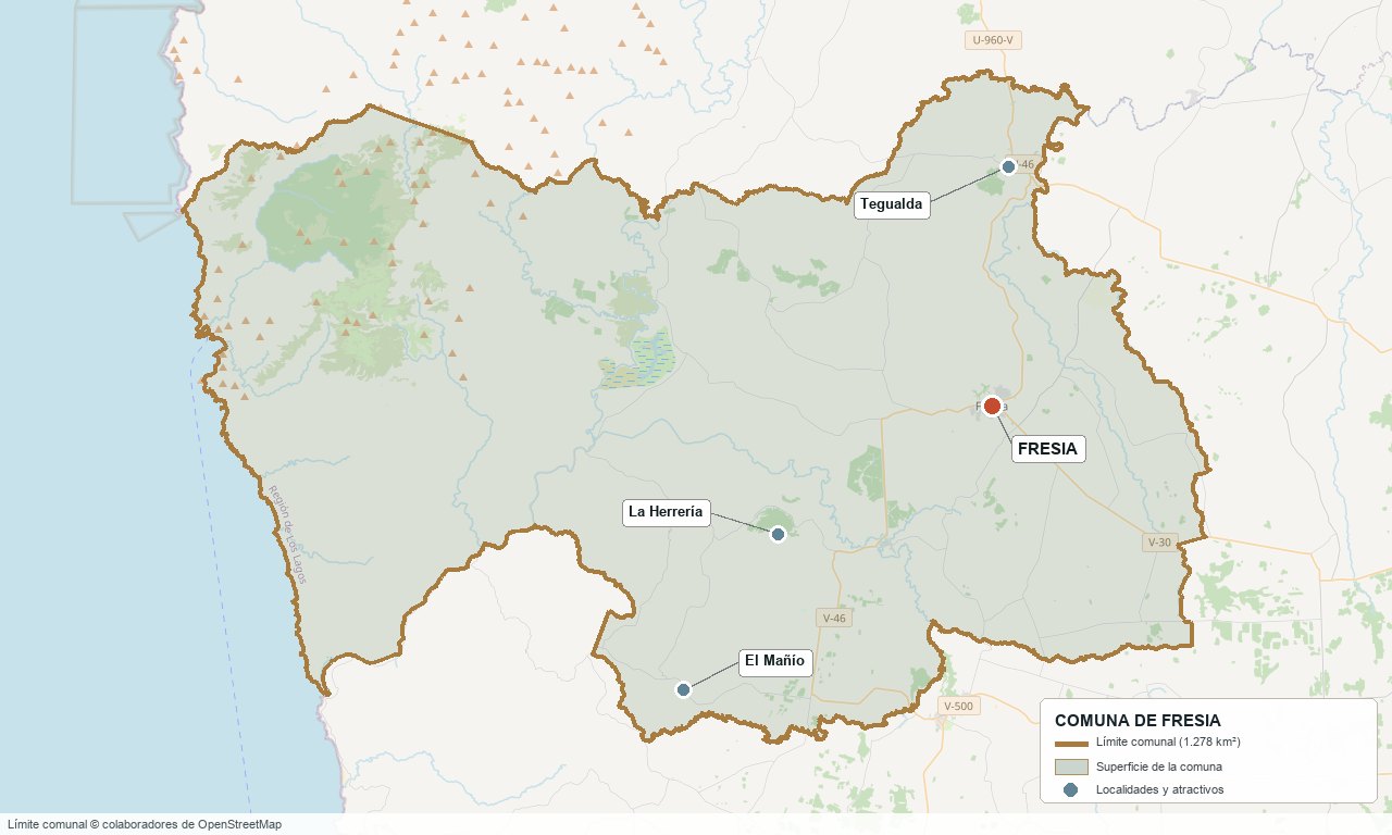
Commune boundary according to OpenStreetMap open data
§ 03 Location, Geography and Territory View
Where Fresia is, what it is built on and why its soil matters.
3.1 Location
The Municipality places Fresia 70 km from Puerto Montt and 38 km from Ruta 5 Sur (Route 5), which does not pass through the commune. Access is by Route V-20, toward Frutillar; V-30, toward Llanquihue and Route 5; V-46, toward Purranque and Los Muermos; and U-96-V, toward Los Muermos. In a straight line, Tegualda is about 13 km from the city, Los Muermos 27, Frutillar 30 and Puerto Varas 41.
City of Fresia · 41°09′ S, 73°25′ W
3.2 Terrain and setting
The city sits in a flat valley surrounded by hillsides and hills, at about 150 m elevation. According to our own grid of 344 points over a digital elevation model, the commune's mean elevation is about 245 m and the median 170 m, with a range from 0 to 840 m: 43 % of the area lies between 100 and 200 m and 24 % above 300 m. The high ground is in the west, in the Cordillera de la Costa, with calculated elevations above 800 m; there are no verified official names for those hills. The central valley, between 130 and 165 m, holds Fresia (149 m), Tegualda (150 m) and Polizones (133 m).
3.3 Hydrography
Main bodies of water in the commune6 rows
| Watercourse | Role in the territory |
|---|---|
| Llico River | One of the main rivers in the province; its mouth is on the boundary with Los Muermos, and several kilometers of its course belong to Fresia. The Municipality uses it for water sports. |
| Norte and Las Caulles Rivers | They cross the city of Fresia; their deposits have very high susceptibility to overflow flooding, according to the zoning plan study. |
| Toro River | It runs through Tegualda and its current deposits have very high susceptibility to flooding. |
| Parga, Cañal, Maule and other rivers | They appear with stretches inside the commune polygon in OpenStreetMap and match the names on the commune's list of rivers; it was not verified which of them originate within it. |
| Laguna Las Ortigas (Ñapeco) | A lagoon of about 4 km, fed by the Huellusca River; the commune development plan records the local legend that Osorno lies sunken beneath its waters. |
| Pacific Ocean | A coastal front of about 40 km, nearly uninhabited, with Punta Capitanes, Playa Las Iglesias and Punta El Peligro. |
3.4 Soils
According to the 2012 CIREN study, cited in the zoning plan's explanatory report, 47.5 % of the territory (79,059 ha) is Class VII, concentrated in the Cordillera de la Costa and the coastline, suited to forestry. Classes II and III add up to 25.4 % and lie around the city of Fresia; classes IV to VI, 26.9 %. The valley soils have a permeable, well-drained profile, with a pH of 5.6 to 6.2 and an almost total scarcity of phosphates. The cartographic bases differ: the sum of the classes in the study exceeds the official commune area by 30 %, so only the percentages are used.
- Advantage: the Class II and III soils around the city are the best for farming in the commune.
- Limitation: almost half of the commune is Class VII, with forestry suitability; cropland covers only 276 ha according to CONAF (2016).
- Risk: in flat or low-lying areas dense profiles form with a high water table, and in river floodplains surface water comes close to the surface.
- Real estate implication: the same lot size can be a cattle farm on Class II-III soil, a forested hillside or a floodable low spot: soil is judged on site and in the certificate, not in the listing.
§ 04 Climate and Seasonality View
A temperate rainy climate with a long winter and a short summer: water sets the calendar.
The commune has a temperate rainy climate, type Cfb in the Köppen classification. There are no 1991-2020 climate normals within it: the INIA Polizones station (DMC 410030), which has measured precipitation in the commune since 2011, has no published normals, nor do the Frutillar, Llanquihue or Puerto Varas stations. Normals exist only at El Tepual, about 42 km from the city, and at Cañal Bajo, Osorno, about 67 km away. Fresia lies between the two and closer to the coast and the mountains than either: the figures are a regional reference.
Reference climate parameters (1991-2020 normals)6 rows
| Parameter | El Tepual | Osorno, Cañal Bajo |
|---|---|---|
| Mean annual temperature | 10.3 °C | 11.3 °C |
| Mean maximum temperature | 15.0 °C | 16.7 °C |
| Mean minimum temperature | 6.2 °C | 5.9 °C |
| Annual precipitation | 1,565.6 mm | 1,235.5 mm |
| Wettest month | June, 213.4 mm | June, 203.6 mm |
| Driest month | February, 69.0 mm | January, 40.9 mm |
Reference station: El Tepual (DMC), 1991-2020 normals, about 42 km from the city in a straight line. Between April and August 57 % of the annual rain falls, and February is the only month below 70 mm: water is plentiful in winter and scarce between September and April, just when the farmland needs it.
The El Tepual normals show a trend toward less rain: 1,844.7 mm in 1931-1960, 1,802.5 mm in 1961-1990, 1,615.4 mm in 1981-2010 and 1,565.6 mm in 1991-2020. Wind and frost-day data could not be verified.
§ 05 History: From the Battle of El Toro to the Zoning Plan View
A territory of passage that became a commune in 1927 and still debates where its city begins and ends.
-
19th century
The Camino Real
The commune development plan places most of Fresia's heritage buildings along the route of the Camino Real. In the second half of the century the church and cemetery of Tegualda, of Spanish influence, are built.
-
1820
Battle of El Toro
On 6 March, at the El Toro estate (Polizones), patriot forces under Colonel Jorge Beauchef, arriving from Valdivia, defeat royalist troops returning from Chiloé. A monolith from 1982 commemorates the event and the commune marks it every year.
-
Late 19th - early 20th century
German colonization with Chilote labor
They leave behind houses such as the Beyer-Rehbein and Rehbein-Schnettler houses in the center, built in the first half of the 20th century. The Espíritu Santo parish, from 1907, preserves sculptures by the German sculptor Peter Horn.
-
1927
The commune is born
Supreme Decree 8583, of 30 December 1927, creates the commune during the first government of Carlos Ibáñez del Campo. Until then it had been dependent on Maullín.
-
1928
First board of mayors
On 13 February the first board of mayors is appointed, and it is constituted on 26 February in a ceremony presided over by the intendant of Chiloé. The Municipality first operated in Las Beatas, 1 km from its current location.
-
1935
The station arrives
According to a November 1935 note in El Llanquihue cited by Wikipedia, the Fresia station on the Corte Alto–Los Muermos branch line was inaugurated. The Municipality dates the first mayor elected by popular vote to 1935; sources disagree on his name, so it is not given.
-
1958
Urban limit of Tegualda
On 7 May the urban limit of Tegualda, set by the Ministry of the Interior, is published. It never had an official map: its boundary is today “unknown” according to the zoning plan's explanatory report.
-
1960
The earthquake and the dairy plant
The commune development plan records that the Lechera del Sur plant in Fresia was destroyed in the 1960 earthquake. There is no specific source on other damage in the commune.
-
1981-82
High school and monolith
The Liceo Carlos Ibáñez del Campo high school is founded (1981, according to Semanario Local) and the monolith of the Battle of El Toro is built (1982).
-
1986-90
End of the railway
Removal of the track is authorized in 1986 and in 1987 the station grounds at Los Muermos and Fresia are put out to tender. Regular passenger service is suspended in 1990.
-
2004
Zoning plan
On 19 January the commune zoning plan is published in the Diario Oficial (official gazette), with 317.1 urban hectares for the city of Fresia and part of Las Beatas.
-
2017-2020
Update of the plan
The update of the zoning plan begins. In 2019 a preliminary draft of 548.6 ha is presented, and in February 2020 the regional Environment office (SEREMI) reports that the strategic environmental assessment was applied. No approval was found.
-
2022
Tegualda rural clinic
The Consultorio General Rural de Tegualda (Tegualda rural general clinic) is inaugurated, joining the hospital and the rural health posts.
-
2026
No CESFAM and outside the intercommunal plan
On 11 August the Undersecretariat of Healthcare Networks replies that there is no technical feasibility for an urban CESFAM (family health center) in Fresia (the hospital fills that role). That same day the Regional Government starts the Llanquihue Intercommunal Zoning Plan, whose study area does not include Fresia.
§ 06 Cultural Identity and Indigenous Peoples View
Almost one in four people identifies with an Indigenous people, and the commune has a Mapuche cultural complex that the commune development plan calls unique in the country.
According to the 2024 Census, 23.6 % of the population identifies as belonging to an Indigenous people (2,904 people), somewhat below the regional average (26.6 %) and more than double the national one (11.4 %). The commune development plan, using 2017 Census data, gave 24 % and recorded 19 Indigenous communities formed before the municipality; this is not the CONADI registry, which was not consulted. It describes a “strong presence of a Huilliche-Mapuche community.”
The cultural layers of Fresia5 rows
| Tier | Visible traces today |
|---|---|
| Mapuche-Huilliche | Intercultural Mapuche Complex in Las Beatas, described in the commune development plan as “unique of its kind in the country,” with capacity for about 1,000 people. Palín, the game of chueca, is kept alive in Tegualda, and the We Trupantu (Mapuche New Year) is celebrated between 20 and 24 June. |
| Camino Real and Spanish heritage | Church and cemetery of Tegualda (19th century) and most of the commune's built heritage, along the route of the old road between Valdivia and Chiloé. |
| German colonization with Chilote labor | Beyer-Rehbein and Rehbein-Schnettler houses in the center and the Espíritu Santo parish (1907), with sculptures by Peter Horn. |
| Trades | The commune development plan records the smithy of Juan Aburto, in El Jardín, as “the last blacksmith in the area,” with a trade that he says dates back to the 17th century. This is 2019 data: it was not verified that it is still open. |
| Recent arrivals | People born outside the country were 0.4 % in 2017 and 1.4 % in 2024. |
The calendar shows the mix: the Festival de la Garza, a festival of young singers, has been held since 1978; the traditional festivals of the potato, the apple, the strawberry and lamb coexist with the commemoration of the Battle of El Toro, the We Trupantu and the Mapuche Women's Day.
§ 07 Key Demographic Data View
7.1 Population and growth
Comparative demographic indicators12 rows
| Indicator | Commune | Region | Country |
|---|---|---|---|
| Population, 2017 Census | 12,261 | — | 17,574,003 |
| Population, 2024 Census | 12,320 | — | 18,480,432 |
| Intercensal change | +0.5 % | +7.4 % | +5.2 % |
| Commune area | 1,278.1 km² | — | — |
| Population density (2024) | 9.6 inhabitants/km² | — | — |
| Rural population (2024) | 38.8 % | 29.0 % | 13.3 % |
| Foreign-born population (2024) | 1.4 % | — | 8.7 % |
| Masculinity index (2024) | 98.1 | 96.5 | 94.3 |
| Older adult index (2024) | 108.1 | 75.8 | 79.0 |
| Indigenous population (2024) | 23.6 % | 26.6 % | 11.4 % |
| People with disabilities, aged 5 or older (2024) | 14.2 % | 11.0 % | 11.1 % |
| Average schooling (2024) | 8.5 years | 9.8 years | 10.4 years |
7.2 Age structure (2024 Census)
Population distribution by age group5 rows
| Age group | Population 2024 | % Commune |
|---|---|---|
| 0 – 14 years | 2,035 | 16.5 % |
| 15 – 29 years | 2,303 | 18.7 % |
| 30 – 44 years | 2,246 | 18.2 % |
| 45 – 64 years | 3,537 | 28.7 % |
| 65 years and over | 2,199 | 17.8 % |
Fresia is aging without growing. It added 59 inhabitants between 2017 and 2024 (+0.5 %), against 7.4 % in the region, and its older-adult index went from 79.1 to 108.1: there are more people aged 65 or older (2,199) than under 15 (2,035). The city of Fresia went from 7,331 inhabitants in 2017 to 7,394 in 2024, while Tegualda, the second locality, fell from 812 in 2002 to 657 in 2017 and to 585 in 2024 (−11 % over the last seven years).
61 % of the population lives in urban areas, but the census classifies 7,539 inhabitants as urban and the city of Fresia totals 7,394: the difference of 145 people points to another, smaller settlement that was not identified. In 2017 the census districts were Fresia (8,145 inhabitants), Tegualda (1,436), Llico (939), Cañal (887), Parga (640) and La Costa (211); the Tegualda district is larger than the village.
§ 08 Economic and Socioeconomic Data View
8.1 Poverty and social indicators (Casen 2024 and Registro Social de Hogares)
Social indicators compared5 rows
| Indicator | Commune | Region | Country |
|---|---|---|---|
| Income poverty, Casen 2024 | 21.4 % | 16.5 % | 17.3 % |
| Multidimensional poverty, Casen 2024 | 20.6 % | 16.3 % | 17.7 % |
| People in households lacking basic services (RSH, June 2026) | 31.4 % | 22.8 % | 12.9 % |
| Overcrowded households (RSH, June 2026) | 5.8 % | 7.1 % | 7.8 % |
| Population born outside the country, 2024 Census | 1.4 % | — | 8.7 % |
Casen 2024 uses a new methodology and is not comparable with 2022 (11.2 % income poverty and 28.6 % multidimensional in the previous edition of the report): it cannot be concluded that income poverty nearly doubled. What can be read is the relative position: Fresia's income poverty is above the regional and national rates, and multidimensional poverty (20.6 %) is also above both. Overcrowding is low (5.8 %), but almost a third of people (31.4 %) live in households without complete basic services, compared with 22.8 % regionally: in a commune with a 38.8 % rural population, this points to water, sanitation and electricity.
8.2 Economic activity (SII) and municipal finances (SINIM)
Business structure and municipal finances10 rows
| Economic indicator (SII / SINIM) | Value |
|---|---|
| Registered businesses, 2024 | 1,050 (micro 665, small 162, medium 15, large 1, no sales 207) |
| Businesses in agriculture, livestock, forestry and fishing, 2024 | 370 (35.2 %); region 11.0 %; country 6.3 % |
| Dependent workers, 2024 | 1,632; in agriculture 463 (28.4 %; region 19.0 %; country 8.2 %) |
| Dependent workers by sector, 2024 | Administrative and support services 318 · commerce 275 · public administration 194 · transportation 123 · construction 79 · manufacturing 69 · education 42 |
| Municipal revenue, 2025 | $6,116 million (≈ $496,000 per inhabitant) |
| Dependence on the Fondo Común Municipal (Municipal Common Fund), 2025 | 59.9 % of total income ($3,661 million); permanent own income 16.3 % |
| Municipal business licenses | $83.1 million in 2025 ($135.7 million in 2023) |
| Vehicle circulation permits, 2025 | $193.5 million |
| Property tax accruing to the municipality, 2025 | $424.5 million |
| Aquaculture licenses (Law 20,033), 2023-2025 | 0 |
Six of every ten pesos of the municipality come from the Municipal Common Fund, that is, from redistribution from richer communes, and the own revenue base is modest: commercial licenses fell from $136 million to $83 million between 2023 and 2025. The business profile hardly changed in a decade: the commune development plan, using SII data from 2014 to 2016, already counted 373 agricultural businesses, 220 in commerce and 48 in transportation.
§ 09 The Productive Engine: Family Farming, Pastures and Forestry Plantations View
The value of Fresia's land is split between a valley of pastures and a coastal range that is turning into plantation.
9.1 Livestock and dairy
The latest agricultural census with commune-level figures at hand is the 2007 one: Fresia had 1,084 holdings and 122,315 ha, with 61.1 % in pasture and 58,436 head of cattle, with no breakdown by species. The zoning plan's explanatory report adds that INDAP (the agricultural development institute) registered more than 320 small farmers and a little over a hundred medium and large ones. The commune-level results of the 2021 Agricultural Census could not be obtained.
There is no verified operating dairy plant in the commune. The zoning plan's explanatory report describes the former Nestlé industrial plant, abandoned on the east side of the city. The commune development plan records that the Lechera del Sur plant was destroyed in the 1960 earthquake, and the 2004 zoning plan prohibits dairy plants in zone ZU-2. In 2014, Watt's operated a network of milk tanks with 40 small producers in Fresia (ODEPA). Nor is there a livestock auction: the SAG, in its 2017 report, places the region's auctions in Osorno, Puerto Montt, Puerto Varas and Purranque. In the commune development plan workshops, residents said that agriculture, dairy and livestock are not profitable under current conditions and that collection centers are lacking.
Weight of farming and forestry in Fresia5 rows
| Indicator | Fresia | Region | Country |
|---|---|---|---|
| Businesses in agriculture and fishing as a share of the total (SII, 2024) | 35.2 % | 11.0 % | 6.3 % |
| Dependent workers in the sector as a share of the total (SII, 2024) | 28.4 % | 19.0 % | 8.2 % |
| Employed in agriculture, hunting, forestry and fishing (commune development plan 2010-2014) | 45.5 % | — | — |
| Area covered by forests, native and plantations (CONAF, 2016) | 60.0 % | — | — |
| Cropland area (CONAF, 2016) | 0.2 % (276 ha) | — | — |
9.2 The forest and the plantations
According to CONAF (2016), forests, native and plantations without breakdown, cover 76,572 ha, 60 % of the commune. A January 2026 BioBioChile article credits Fresia with about 10,042 ha of forestry plantations, the second-largest figure in the region after San Juan de la Costa (10,294 ha); the figure carries no explicit commune-level source and looks high against the 18,137 ha for the whole province cited in the same report, so it is taken as press data. The 2007 Census counted 26 forestry holdings occupying 57,705 ha, 47 % of the area in use.
The zoning plan's explanatory report and the commune development plan agree: eucalyptus changed land use from agricultural to forestry, forestry companies bought large numbers of properties and that speeds up migration from the countryside to the city. In the 2023 water dialogue, residents named the loss of native forest and plantations as the greatest threat to water.
9.3 Other economic pillars
- Fishing and aquaculture: fishing employed 1.2 % of the employed (commune development plan 2010-2014) and the municipality's aquaculture licenses are zero. The zoning plan's explanatory report records a fish farm on the Esperanza River and another near the city, with environmental assessments approved between 2004 and 2012; residents mention pollution attributed to the aquaculture industry.
- Commerce and services: 280 commerce businesses, 68 in transportation and 64 in lodging and food service in 2024. Commerce employs 275 salaried workers and public administration 194.
- Potatoes and crops: there is a Potato Festival, but no commune-level figure for hectares of potatoes or cereals was found; crops total 276 ha according to CONAF (2016).
- Employment: the commune development plan recorded unemployment of 15.5 % in 2010-2014, 54 % of it rural. It is old data, but consistent with a countryside that pushes people out.
§ 10 Real Estate Market View
10.1 Available properties and property types
The supply is almost all rural land. Among the listings on Yapo, Portal Inmobiliario and Chilepropiedades (consulted on 10 and 11 November 2026) there are 128 unique land listings in Fresia, 102 with usable area, and 41 are parcels of between 4,500 and 6,500 m². Farms of more than 3 ha number about 47. Produncan Lands markets ten properties within the commune boundaries.
10.2 Average price by property type (indicative, November 2026)
Indicative price ranges by property type (asking prices, UF at $41,302)6 rows
| Property type | Indicative price range | Notes |
|---|---|---|
| Parcel of ~5,000 m² | Median 605 UF (≈ $25 MM); middle half 460-1,139 UF | 41 listings; about 1,200 UF/ha. By portal: Yapo 532 UF (37 listings), Portal Inmobiliario 533 UF (21) and Chilepropiedades 681 UF (6). Figures by portal include repeated listings, which were removed from the total. |
| Lot of 0.65 to 3 ha | Median 1,283 UF (≈ $53 MM); middle half 981-2,572 UF | 14 listings; about 1,120 UF/ha. |
| Farm of 3 to 10 ha | Median 2,845 UF (≈ $117.5 MM); middle half 2,028-5,353 UF | 18 listings; about 455 UF/ha. |
| Farm of 10 to 50 ha | Median 9,600 UF (≈ $396.5 MM); middle half 6,676-10,600 UF | 15 listings; about 335 UF/ha. Those of 26 to 32 ha with a paved road: 10,000-11,622 UF, or 330-450 UF/ha. |
| Farm of more than 50 ha | Median of about 20,400 UF (≈ $841 MM) | 14 listings, very heterogeneous (about 160 UF/ha). Forestry or native-forest properties of 57 ha in the Llico area: 80-110 UF/ha. |
| Parcels by sector | Between 290 and 1,750 UF | The stretch along the Llico River, Llico Alto and Tegualda runs around 340-780 UF; those with a water network or a condominium project, 530-970 UF; the most expensive, in a low-density nature reserve in Mañío-Llico, 1,750 UF. |
These are listing prices, not closing prices, and Yapo and Portal Inmobiliario show no date, so they mix old and current postings; only Chilepropiedades dates its listings (between 14 March and 10 November 2026). Comparing Yapo against Yapo on the same day, the ~5,000 m² parcel has a median of 532 UF in Fresia, 12 % less than in Los Muermos (605 UF), about 35 % less than in Purranque (813 UF) and about 3.6 times less than in Puerto Varas (1,937 UF, in a sample of 120 listings that is not random). Fresia has some of the cheapest parcels in the province.
As for the cycle, applications to subdivide rural properties fell 62.4 % in the first half of 2025 compared with the same period of 2022 (Diario Financiero, 2025). The same report quotes experts who speak of the end of the parcel “boom”, of oversupply and of falling prices, in an adjustment of two to five years.
10.3 What determines price in Fresia
Valuation factors in this market, ordered by the available local evidence5 rows
| Factor | Price impact | How to check it here |
|---|---|---|
| Piped water or condominium project | 530-970 UF against 340-780 UF along the Llico River, Llico Alto and Tegualda | Ask for service feasibility and, if there is an APR (rural drinking water system), the health resolution. In Tegualda the water belongs to the APR committee and the municipal sewerage is deficient. |
| Paved road on farms | 330-450 UF/ha on farms of 26 to 32 ha with a paved road, against 80-110 UF/ha on remote forestry properties | Check the condition of the road in winter: residents say forestry trucks damage rural roads. |
| Protected natural setting | Up to 1,750 UF for the most expensive parcel | It is a project in a low-density reserve in Mañío-Llico: ask for the subdivision rules. |
| Neighboring plantations | No measured differential | Look at the surroundings on the map and on site: water, trucks and fires (the last major fire was in February 2019). |
| Flooding or waterlogging | No measured differential | Residents point to the Bórquez neighborhood and the Refri, Esperanza, Peuchén, Maichihue and Traiguén areas; check the water table between May and August. |
§ 11 Land-Use Planning in Fresia View
Fresia has a zoning plan, but only for its city: Tegualda and the whole countryside are governed as rural land.
The city of Fresia has had a commune zoning plan in force since 19 January 2004, with 317.1 urban ha that include the city and part of the Las Beatas area. It defines nine zones: three consolidated (ZU-1, ZU-2 and ZU-3), two expansion (ZEX-1 and ZEX-2), one for sports facilities (ZE-1), one for a cemetery (ZE-2) and two restriction zones, for protection of springs and watercourses (ZR-1) and for the cemetery (ZR-2). Tegualda is not in the plan: it has only an urban limit published on 7 May 1958, with no official map, and the zoning plan's explanatory report describes it as having an “unknown layout.”
Planning instruments affecting the commune4 rows
| Instrument | What it regulates | Status |
|---|---|---|
| 2004 commune zoning plan | City of Fresia and part of Las Beatas (317.1 ha), in nine zones. It prohibits dairy plants in zone ZU-2. | In force. |
| 1958 urban limit of Tegualda | Only a limit, with no official map or known area. | In force, but with an uncertain layout. |
| Zoning plan update | 2019 preliminary draft: 548.6 urban ha (Fresia 464.9 and Tegualda 83.7), 22 developable zones, two risk areas and 13 buildings of historic conservation. | In process since 2017; the regional Environment office (SEREMI) reported on 3 February 2020 that the strategic environmental assessment was applied. No approval decree was found. |
| Plan Regulador Intercomunal de Llanquihue (intercommunal zoning plan) | Lake Llanquihue basin: Puerto Octay, Frutillar, Llanquihue, Puerto Varas, Puerto Montt, Calbuco, Maullín and Los Muermos. | Begun on 11 August 2026 by the Regional Government. Fresia is not in the study area: the text of the resolution does not mention it. |
The 2019 preliminary draft proposes “moderate growth” of the urban limit, from 317 to 549 ha (+73 %), precisely so as not to occupy the Class II and III farmland on which the city has already grown to the north and west. The explanatory report identifies as limits to growth the canals and streams (the Alvarado stream to the east and the Antiguo stream inside the founding area), the slopes of Las Beatas and, in Tegualda, a watercourse that divides the town into upper and lower parts.
The risk study, which covers only the urban areas of Fresia and Tegualda, rates as very highly susceptible to overflow flooding the current deposits of the Norte and Las Caulles rivers in Fresia and of the Toro in Tegualda, and as very high for waterlogging the depressions of about 1.5 m with poor drainage. Mass movement is very high on slopes of more than 35 degrees. The explanatory report does not give the hectares of those areas. Outside the urban zones, occupation advances through subdivisions of more than 5,000 m² around the city and Las Beatas, along routes V-30 and V-300.
On protected areas: no official protected area was identified within the commune, and the Humedales del Río Maullín Nature Sanctuary does not include it. The plan's explanatory report does record, however, the priority conservation site “Cordillera de la Costa” (316,188 ha, covering Fresia, San Juan de la Costa, Río Negro, Purranque and part of Los Muermos) and two private protected areas. Intervening in native forest requires a management plan filed with CONAF (Law 20,283). No tsunami flood chart was found for the coastline.
§ 12 Neighbourhoods and Areas View
The commune is organized around one city and a handful of scattered rural localities. The city of Fresia holds 7,394 inhabitants; the second, Tegualda, barely 585. In the 2017 Census there were six census districts, of which Fresia accounted for 8,145 of the 12,261 inhabitants.
Sectors of the commune and their profile7 rows
| Sector | Features | Market profile |
|---|---|---|
| City of Fresia | Commune seat, at 149 m, with 7,394 inhabitants in 2024. Hospital, high school and commerce. To the east are the abandoned facilities of the former Nestlé plant, and the sawmills send trucks through the city. | Urban lots within the 317 ha of the zoning plan; around it, rural subdivisions. |
| Las Beatas | 3 km from the city in a straight line. First seat of the Municipality and seat of the Intercultural Mapuche Complex; the zoning plan includes it in part, and there are slopes. | Subdivisions of more than 5,000 m² along routes V-30 and V-300. |
| Tegualda | About 13 km from the city in a straight line, at 150 m, with 585 inhabitants in 2024 (657 in 2017 and 812 in 2002). Rural clinic and rural emergency service, APR committee, 19th-century church and a paved road directly to Fresia. | Parcels of between 340 and 780 UF along the Llico River, Llico Alto and Tegualda; 1958 urban limit with no map. |
| Polizones | About 7 km from the city, site of the Battle of El Toro (1982 monolith), of the INIA Polizones station and of a school and a rural health post. | No price sample of its own. |
| Parga and El Mañío | Parga, at 9 km, has a school, a rural health post and a San Sebastián chapel. El Mañío is about 22 km away and at 252 m, with a rural school and health post. | No price sample of its own; the most expensive subdivision (1,750 UF) is in Mañío-Llico. |
| La Herrería and Llico Alto | About 13 km from the city, on route V-332, around the Llico River. Residents point out that there is no public access to the Llico Alto waterfall. | Parcels and farms with native and commercial forest, from 80 to 780 UF depending on the case. |
| Cordillera de la Costa and coastline | Western sector, with elevations of more than 800 m, forest, plantations and a coastline of about 40 km. At Punta Capitanes, the commune development plan recorded in 2019 roads in poor condition and land without regularized title. | Forestry and native-forest properties; no price sample of its own. |
§ 13 Basic Services, Utilities and Digital Connectivity View
Practical information that rarely appears in descriptions of a commune but that nonetheless determines whether any property is viable.
Service providers and coverage6 rows
| Service | Provider / operator | Practical notes |
|---|---|---|
| Electricity | CRELL (Cooperativa Rural Eléctrica Llanquihue, Llanquihue Rural Electric Cooperative) | Founded in 1948 in Fresia by 39 farmers; it now serves more than 35,000 customers in several communes. In July 2025 a letter published in CIPER said that Fresia residents gathered signatures over repeated outages and voltage drops; it is a reader's letter, not a news report. The April 2025 outages in Cañitas and Río Frío are in Los Muermos. |
| Urban drinking water | ESSAL | It operates in the city. Urban drinking water coverage was not verified. |
| Rural drinking water | APR committees and cooperatives | Tegualda has an APR committee. The Huempeleo–Alto Bonito APR project was approved by the Regional Council in December 2020 (85.7 % progress in a Dipres listing, with no clear date); its current status is not verified. |
| Sewerage | ESSAL in the city; Municipality in Tegualda | In 2016 urban coverage was 87.7 %, with an activated sludge plant that discharges into the Norte River; there are outlying areas outside ESSAL's operating territory, with no network. In Tegualda the municipal network, from 1998, is deficient: about 300 connections, 75 % of the homes. |
| Internet and phone | Mobile and fixed operators | There is no coverage verification by property. Tegualda's rural school is listed with 3G technology in 2025 Subtel reports: do not take internet for granted; measure on site. |
| Household waste | Final disposal at the La Laja landfill (Puerto Varas) | The landfill serves nine communes. In October 2026 the Puerto Varas municipal council halted the expansion (cell 3); with cell 2 at 88.9 % occupancy in June 2026, without works there would be no disposal site from August 2027. The later outcome was not verified. |
§ 14 Health View
Unlike its neighbor Los Muermos, Fresia does have a hospital, a low-complexity one, but it has no urban CESFAM and will not get one.
The commune belongs to the Servicio de Salud Reloncaví (Reloncaví Health Service) network. According to the BCN Commune Report (July 2026), it has ten facilities: one hospital, eight rural health posts and one rural general clinic; it has no CESFAM or SAPU. The hospital also serves as the city's primary care. On 11 August 2026 the Undersecretariat of Healthcare Networks replied that “there is no technical feasibility for the creation of an Urban CESFAM” in Fresia.
The commune's health network4 rows
| Facility | Type | Detail |
|---|---|---|
| Fresia Hospital | Low-complexity hospital | San José 301. 29 beds enabled and 28 operational in July 2025; more than 17,000 enrolled patients, including users from Los Muermos, Purranque and Puerto Varas; about 10 general physicians and 5 dentists, with specialists through the network. It was accredited until September 2025; renewal not verified. |
| Tegualda Rural General Clinic | Rural clinic | Inaugurated in 2022. |
| Tegualda Rural Emergency Service | Rural emergency service | Low complexity, with sector funding. |
| Health posts of Cau Cua, El Mirador, Las Cruces, Línea Sin Nombre, Mañío, Parga, Polizones and Traiguén | Rural health posts | Eight posts according to the public directory. The Traiguén post, with a replacement financed by the Regional Government, was abandoned by the contractor at 77 % progress; it is still pending. |
Validated enrollees in primary care total 7,497 (December 2025), while the hospital reports more than 17,000: the figures are not comparable, because the hospital serves population from other communes. Calls to 131 are received by the Puerto Montt Regulating Center; a SAMU base in Fresia was not verified, and the nearest known one is in Frutillar.
§ 15 Education View
15.1 School education
In 2025 the commune had 2,321 students (2,402 in 2023) and 21 schools: 8 subsidized private and 13 dependent on the Servicio Local de Educación Pública (SLEP, Local Public Education Service) Llanquihue, headquartered in Frutillar, to which the municipal schools were transferred. No municipal schools remain. In addition, the SLEP runs two kindergartens in the commune.
Featured schools6 rows
| Facility | Type | Distinction |
|---|---|---|
| Liceo Carlos Ibáñez del Campo | SLEP Llanquihue | The city's high school, at B. O'Higgins 210, founded in 1981. Its program type and enrollment were not verified. |
| Escuela Básica Fresia | SLEP Llanquihue | The city's school, at San Carlos 102. |
| Escuela Rural San Andrés de Tegualda | SLEP Llanquihue | 151 students, with 3G technology, according to Subtel. |
| Escuela Rural Lucila Godoy Alcayaga | SLEP Llanquihue | In El Mañío, km 34. |
| Colegio Purismo Corazón de María | Subsidized private | At Irarrázabal 420, Fresia. |
| Escuela Rural Olga Soto Alvarado | SLEP Llanquihue | In La Isla; the SLEP announced its closure in December 2024. The current status was not verified, and the 2026 list still includes it. |
SIMCE 2025 results (preliminary)7 rows
| SIMCE test | Commune | Region | Country |
|---|---|---|---|
| Grade 4, reading | 267 | 275 | 276 |
| Grade 4, mathematics | 249 | 259 | 262 |
| Grade 8, reading | 223 | 236 | 238 |
| Grade 8, mathematics | 236 | 255 | 258 |
| Grade 8, history | 228 | 247 | 250 |
| Grade 10 (II medio), reading | 228 | 245 | 250 |
| Grade 10 (II medio), mathematics | 226 | 255 | 263 |
The pattern is clear and adverse: Fresia falls below the region and the country at all levels and on all tests. The largest gap is in Grade 10 (II medio) math (29 points below the region) and in Grade 8 math (19 points). The average schooling of the adult population, 8.5 years against 9.8 in the region, points in the same direction.
15.2 Higher education
No university, professional institute or technical training center campus was found in the commune. The CFT Estatal de Los Lagos (Los Lagos State Technical Training Center) is based in Llanquihue, and the nearest alternatives are Puerto Montt, Osorno and Puerto Varas. The commune development plan notes that young people from Tegualda migrate to study in Frutillar, Purranque and Río Negro.
§ 16 Cordillera de la Costa, Wetlands and the Remote Coastline View
Fresia's natural setting is not one of lakes or volcanoes: it is a coastal range with forest, plantations and hillside soils, a hidden lagoon and a coastline of about 40 km, almost without inhabitants. The tourism offer is incipient: the 2024 regional guide to Los Lagos attractions does not mention Fresia.
Natural attractions by distance from the city of Fresia (in a straight line)5 rows
| Attraction | Approx. distance | Activities |
|---|---|---|
| Battle of El Toro Monument | 7 km | 1982 monolith in Polizones, with a commemoration every 6 March. |
| Llico River and La Herrería | 13 km | Water sports promoted by the Municipality; no public access to the Llico Alto waterfall. |
| Laguna Las Ortigas (Ñapeco) | 18 km | A lagoon of about 4 km, fed by the Huellusca River; the commune development plan calls it “Laguna Encantada” (Enchanted Lagoon). |
| Playa Las Iglesias and Punta El Peligro | 39 km | Open Pacific coast, nearly uninhabited. |
| Punta Capitanes | 42 km | Cape and coastal hamlet. In 2019 the commune development plan described it as the “last sector of the commune” and hard to reach; residents of the area who met that year complained of roads in poor condition and land without regularized title. |
Cordillera de la Costa, Las Ortigas lagoon and coastline
As for protected areas, no official one was identified within the commune, neither national park nor sanctuary: the Humedales del Río Maullín Sanctuary reaches five other communes, not Fresia. The priority conservation site “Cordillera de la Costa” and two private protected areas do appear, according to the zoning plan's explanatory report.
§ 17 Connectivity and Transportation View
17.1 Road network
Ruta 5 Sur (Route 5) does not pass through the commune: the V-20 and V-30 link the commune to it on the east side. The V-30 is the axis that joins the city with Route 5 at Llanquihue, and at the zoning plan's control point it recorded an average daily traffic of 1,725 vehicles between 2006 and 2016, with 11.5 % trucks and 3.8 % semi-trailers. Logging trucks cross the city of Fresia for lack of alternatives, and residents point to rural roads damaged by their traffic.
Routes and distances6 rows
| Route / destination | Distance and details |
|---|---|
| Route V-30 | Joins Fresia with Llanquihue and Route 5. Vialidad (the national roads directorate) is conducting an engineering study to improve it; it is not a confirmed project. |
| Route V-20 | Joins Frutillar, Tegualda and Fresia. The MOP (Ministry of Public Works) announced paving of 16 km of the last stretch (investment of $1,599 million, no date); Tegualda has a paved road directly to Fresia. |
| Route V-46 | Toward Purranque and toward Los Muermos: 1,033 vehicles per day toward Fresia and 640 toward Los Muermos (2006-2016). Pavement condition not verified by stretch. |
| Routes U-96-V, V-300 and V-332 | Access to Los Muermos, the Río Frío–Fresia–Polizones axis and the La Herrería road; their condition was not verified. |
| Puerto Montt | About 68 km by road and 55 minutes by car (Rome2rio); by bus, 1 hour 17 minutes. The Municipality gives 70 km. |
| Straight line (not by road) | Frutillar 30 km, Llanquihue 36 km, Puerto Varas 41 km, El Tepual 42 km, Osorno 69 km. By road they will be longer. |
Between Puerto Montt, Osorno and the Pacific
17.2 El Tepual Airport
The Puerto Montt airport, El Tepual, is in the commune of Puerto Montt, about 42 km from the city of Fresia in a straight line; the distance by road was not verified. It is the access airport for those arriving from other regions.
Air terminal fact sheet3 rows
| Fact | Detail |
|---|---|
| Commune | Puerto Montt (not part of Fresia) |
| Distance from Fresia | About 42 km in a straight line; by road, not verified |
| Weather station | DMC code 410005; serves as the climate reference for the commune |
17.3 Road and urban transportation
- Buses: Thaebus connects Fresia with Puerto Montt from the Fresia bus station (phone +56 65 227 8249); the frequency varies among sources and the fare was not verified. Other companies were not verified.
- Rural transport: there are minibuses between Tegualda and Fresia.
- Railway: the Fresia station on the Corte Alto–Los Muermos branch line was inaugurated in 1935. Passenger service was suspended in 1990 and today there is no train; the zoning plan still mentions the “former railway line” at the urban limit.
§ 18 Tourism: Development, Attractions and Things to Do View
18.1 Tourism development
The commune development plan acknowledges the “absence of planning to promote tourism.” The municipal website announces a Tourism Development Plan 2024-2027 and a Municipal Culture Plan 2022-2026, but their documents could not be read: the links return the site's home page.
18.2 Tourist attractions in the commune
- Battle of El Toro Monument: in Polizones, where patriots and royalists clashed on 6 March 1820; the monolith dates from 1982.
- Intercultural Mapuche Complex: in Las Beatas, described by the commune development plan as unique of its kind in the country.
- Tegualda: its 19th-century church and cemetery, on the old Camino Real.
- Beyer-Rehbein and Rehbein-Schnettler houses and Espíritu Santo parish (1907): in the center of Fresia, of German influence.
- Llico River, Laguna Las Ortigas and Punta Capitanes: natural attractions with no developed access or tourism services.
18.3 Museums and culture
No museum was found within the commune. The commune development plan lists a library, gyms, a municipal hall, a cultural center and the Intercultural Mapuche Complex, with capacity for about 1,000 people.
18.4 Food and dining
Fresia's table follows its agricultural calendar: the commune development plan lists the Potato Festival, the Apple Festival, the Strawberry and Lamb Festival and the Maja de la Manzana (apple-crushing festival). Restaurants and food routes were not verified.
18.5 Nature and the outdoors nearby
- Llico River: water sports, according to the Municipality.
- Cordillera de la Costa and coastline: hard to access; at Punta Capitanes residents complain of roads in poor condition.
- Lodging: OpenStreetMap lists a hostel in Tegualda, a rural lodging and a shelter in La Herrería; whether they are still operating was not verified.
18.6 Calendar of events and traditions
Main milestones of the year6 rows
| Period | Event | Character |
|---|---|---|
| 20 January | San Sebastián | Religious festival. |
| 2 February | Candelaria | Religious festival. |
| 6 March | Anniversary of the Battle of El Toro | Commemoration in Polizones. |
| 20 to 24 June | We Trupantu | Mapuche New Year, at the winter solstice. |
| October | Festival de la Garza | Two days of young singers, since 1978. |
| Summer | Country festivals (fiestas costumbristas) | Potato, Apple, Strawberry and Lamb festivals and the fairs of Río Blanco, Llico Alto, Tegualda and Las Beatas; the commune development plan gives no dates. |
§ 19 Everyday Life, Sport and Practical Information View
What anyone who is going to live in Fresia, not just visit it, needs to know.
19.1 Sport and identity
- Rayuela: the Pumalal club had accumulated 24 provincial championships in 27 years (2019 data).
- Palín: the Mapuche game of chueca is kept alive in Tegualda.
19.2 Shopping and supplies
The city covers everyday needs: in 2024 there were 280 commerce businesses. For what is missing — higher education, a higher-complexity hospital, large stores — the nearest cities are Frutillar and Llanquihue, at 30 and 36 km in a straight line, and Puerto Montt, about 55 minutes by car.
19.3 Where to handle paperwork
Services based in Fresia4 rows
| Office | Address or contact | Remarks |
|---|---|---|
| Municipality | San Francisco No. 124 | Seat of the municipality; the website is munifresia.cl. |
| Fresia Hospital | San José 301; phone 65 2 328760 | Appointments via the 800 line, from 7:00 to 10:00 (2025 data). |
| Liceo Carlos Ibáñez del Campo | B. O'Higgins 210 | The city's high school. |
| Bus station | City of Fresia | Departures to Puerto Montt with Thaebus. |
19.4 Cost of living and practical considerations
- On rural parcels, a backup power source (generator or panels) and a well with a flow verified in summer are part of the real cost, not an extra.
- Water is scarce between September and April according to residents: ask for the flow measured in February.
- For more complex paperwork, higher education and large purchases, you take on the cost and time of a trip to another city.
§ 20 Territorial Analysis: Strengths, Challenges and Opportunities View
An honest reading of the territory. A sound investment decision also requires knowing what doesn't work.
- Rooted agriculture: 35.2 % of businesses are agricultural (region 11.0 %) and 25.4 % of the soils around the city are Class II and III.
- Its own low-complexity hospital, a rural clinic and emergency service in Tegualda and eight health posts: a network that its neighbor Los Muermos does not have.
- Zoning plan in force since 2004 for the city of Fresia, with 317 urban ha and defined zones.
- Low entry price: the ~5,000 m² parcel has a median of 532 to 605 UF, compared with 1,937 UF in Puerto Varas.
- Nearly stagnant, aging population (+0.5 % since 2017): 108.1 older adults for every 100 children; Tegualda lost 11 % of its inhabitants since 2017.
- Income poverty higher than the region (21.4 % vs. 16.5 %) and 31.4 % of people in households without complete basic services.
- SIMCE below the region and the country at all levels; no higher-education campus; no urban CESFAM (the Minsal, the Ministry of Health, ruled it out).
- Tegualda has only a 1958 urban limit with no official map, and the 2004 zoning plan is more than twenty years old.
- There is no verified operating dairy plant or livestock auction: the family-farming chain is completed outside the commune.
- The update of the zoning plan, with 549 urban ha and an urban zone in Tegualda, would give regulatory certainty if approved.
- The parcel market is adjusting downward (−62.4 % in subdivision applications): a buying window for those who arrive with the analysis done.
- The new Puerto Varas Hospital (190 beds, planned for 2028) would shorten the distance to medium-complexity care.
- Forestry companies act as an alternative buyer for a farm seller.
- Eucalyptus and pine: plantations advancing over farmland and native forest, with less water, more trucks and fire risk (the last major fire was in February 2019).
- Water scarcity between September and April, with wells dropping and APRs without a health resolution.
- La Laja landfill: without expansion, the nine communes that use it would be left with no disposal site from August 2027.
- Flooding and waterlogging around the Norte, Las Caulles and Toro rivers, and in the Bórquez neighborhood and other areas.
- Legal changes in rural subdivision: stricter SAG criteria and a rural-life bill.
Fresia: Territory, Connectivity and Opportunities
Fresia is today an entry-level territory: land cheaper than that of Purranque and Puerto Varas, a city with a hospital and a zoning plan that, despite its age, exists. But it is also a territory with farms that are sold to forestry companies, water that runs short in summer and a second hub, Tegualda, whose urban limit nobody can draw. The opportunity exists for those who buy informed: a well measured in February, electrical feasibility in writing, a subdivision certificate and a winter visit.
At Produncan Lands we know this territory and its opportunities. Our work is to connect properties with people looking to invest, live and develop new projects in southern Chile, offering our experience, local knowledge and commercial reach.
We invite you to get to know our properties in Fresia and across southern Chile, and to entrust Produncan Lands with the sale of your property.
View properties at Produncan Lands§ 22 Sources and Methodology Note View
22.1 Sources consulted
Documents and sources used11 rows
22.2 Methodology note and data currency
- Casen 2024 uses a new methodology: its poverty figures are not comparable with those of Casen 2022. SIMCE 2025 is preliminary. The figures in the BCN Commune Report were cross-checked against the official page on 11 November 2026.
- The PLADECO 2019-2026, the zoning plan's explanatory report (2019), the 2007 Agricultural Census and the CIREN land-use capability study (2012) are old documents: they are used only where there are no more recent data, and this is indicated. The PLADECO expires in 2026 and no successor was found.
- Left out because they could not be verified: the 2021 Agricultural Census by commune, the fiscal assessed value per hectare, the costs of extending electrical service and of drilling a well, local higher education, the 2024 population of the smaller localities and the commune's own climate normals.
- Straight-line distances and elevation are our own calculations (the latter from a digital elevation model of about 90 m resolution); the travel time to Puerto Montt is a reference from a route-planning portal, not an official figure.
- Llico Bajo is not treated as a locality of Fresia: the commune development plan mentions it among its sectors, but the official commune boundary in OpenStreetMap places it in Los Muermos.
- The price ranges for the real estate market are indicative and do not constitute an appraisal: they are asking prices from listings, and some listings labeled “Fresia” correspond to areas of neighboring communes. Each property must be evaluated individually.
- This document does not constitute legal or tax advice.
- Closing date of this edition: November 2026. It is recommended to review the indicators in sections 7, 8 and 10 annually, and the progress of the zoning plan update (section 11).
Territorial reference document prepared by Produncan Lands. It brings together official information (INE, BCN, SII, SINIM, MINEDUC, DMC, MINSAL) with local market knowledge, so that anyone — neighbor, visitor, investor or buyer — can understand Fresia in depth before making a decision.