
FutaleufúThe border valley of the whitewater river
History, Nature and Opportunities in the Commune of the Río Futaleufú
THE GREAT RIVER
Fütra leufü, “great river” in Mapudungun, is what people call the water that flows down from the Argentine reservoir of Amutui Quimey and enters Chile between hills of lenga and cypress. Around 1910, farming families and Chilotes who had lived in Trevelin crossed the border with axe and fire to clear pastures in the cypress and coihue forest; for decades they traded timber for food and clothing on the other side, and Argentine currency circulated in the town.
A lieutenant of the Carabineros founded the town in 1929, on the terrace where the Río Espolón and the Futaleufú meet. In 1934 a newspaper from Puerto Aysén wrote that its inhabitants did not know they were Chilean. The airplane arrived before the road, which came in 1982. In January 1985 a kayaker ran the river, and in February the first raft stopped at a class V+ rapid that they named Terminator.
Today the town is made of timber-frame houses clad in boards with zinc roofs, and in winter woodsmoke hangs over the Laguna Espejo. In summer the river looks turquoise from the Piedra del Águila trail, with the Tres Monjas peaks in the background, and in late January there is a rodeo at the medialuna. The river, which almost ended up beneath three dams, runs free to Lago Yelcho.
Version 1.0 · Expanded edition · October 2026
The Commune at a Glance
The key facts about Futaleufú at a glance. Each figure is explained in the corresponding section.
Administrative identification and reference data12 rows
| Fact | Detail |
|---|---|
| Official name | Commune of Futaleufú |
| Region / Province | Los Lagos / Palena (Chaitén, Futaleufú, Hualaihué and Palena); the provincial capital is Chaitén |
| Demonym | Futaleufuense (BCN) |
| Civic center coordinates | 43°11′ S, 71°52′ W |
| Area | 1,280 km² (BCN), the smallest commune in the province of Palena |
| Elevation | About 350 m a.s.l. (347 m at the weather station at the airfield) |
| Boundaries | Argentina (Chubut province) to the north and east, Chaitén to the west and Palena to the south |
| Dialing code | +56 65 |
| Time zone | UTC−4 (CLT) / UTC−3 in summer time (CLST) |
| Climate classification | Temperate oceanic with no dry season (Cfb) |
| Town anniversary | 9 April 1929, according to the Municipality (an academic study says 1 April) |
| Municipality | Ilustre Municipalidad de Futaleufú (Municipality of Futaleufú); mayor Fernando Grandón Domke and six council members (BCN, 2026) |
Overview
Futaleufú is a commune of 1,280 km² of mountains, lakes and valleys where 3,062 people live (2024 Census), 2.4 per square kilometer, in the far east of the province of Palena, right up against Argentina. The town is home to 1,996 of them and lies about 10 km from the border, at the confluence of the Río Espolón with the Río Futaleufú, the class IV and V whitewater river that made it world famous; the other 1,066 live in seven rural sectors (Noroeste, El Espolón, Lonconao, Río Chico, Las Escalas, El Azul and El Límite). It does not live off a single activity: the State employs 3 out of every 10 employed residents, commerce and construction another 26 out of every 100, and direct tourism close to 10.5.
Its role is twofold. It is the service town for the valleys of the basin —a low-complexity hospital, a secondary school, a notary, the Conservador de Bienes Raíces (Real Estate Registrar), a bank and the only fuel pump— and it is a gateway to Argentina: for decades Trevelin and Esquel were its supply city and they still are for whatever the town does not have. Toward the rest of Chile the commune is farther away than it looks: there is no continuous Chilean road to Puerto Montt, and the land connection runs through three ferries, or through Argentina, or along a single route to Chaitén, 156 km away.
The contrast with its neighbors defines its character. Palena and Chaitén are communes of the same province, but in the ZOIT action plan (2022) Futaleufú had 178 tourism services and 85 lodgings, against 37 and 24 in Palena. And compared with the resorts of the south, the 2024 Census shows something different: 25.3 % of its dwellings are unoccupied, considerably fewer than in Pucón (53.1 %) or Cochamó (37.6 %), but more than double the national figure (11.9 %). It is a remote nature destination with a town that works all year round, not a resort that empties out in March.
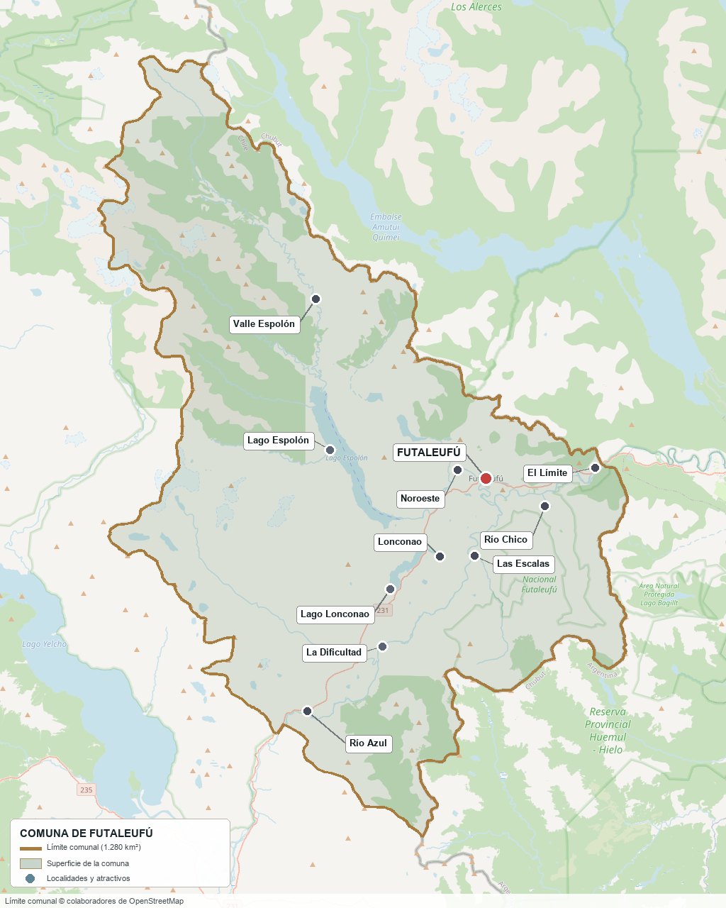
Communal boundary based on OpenStreetMap open data
§ 03 Location, Geography and Territory View
Where Futaleufú is, which valleys make it up, and why its soil is fertile but its water is not distributed equally across all properties.
3.1 Location
Futaleufú is the smallest commune in the province of Palena (1,280 km², a little over 8 % of the provincial area) and lies right up against Argentina: the town, at 43°11′ S and 71°52′ W, is about 10 km from the international border and about 350 m above sea level, at the confluence of the valleys of the Espolón and Futaleufú rivers. To the north and east the commune borders the Argentine province of Chubut (Futaleufú department), to the west Chaitén and to the south Palena. The rest of the territory is organized into one urban sector, the town, and six rural sectors: El Azul, Espolón, Lonconao, Noroeste, Río Chico and Las Escalas; right on the border, next to the border complex, is the settlement of El Límite.
Futaleufú · 43°11′ S, 71°52′ W
3.2 Terrain and setting
It is Patagonian cordillera shaped by glaciers: flat or rolling valley floors at 300 to 400 m of altitude, surrounded by massifs between 1,650 and 2,090 m; the highest in the area is Cerro Cónico (2,271 m), inside the Reserva Nacional Futaleufú. Above the valley floors there are alluvial terraces and fluvioglacial plains; on the slopes, steep deposits with collapses and landslides that the PLADECO calls “corridas” and that sometimes block watercourses. From the trail to the Piedra del Águila (860 m), 4.5 km from the plaza, you can see the Tres Monjas peaks and the Espolón valley. The commune’s only vehicle crossing into Argentina is at Futaleufú, where Chilean route 231 continues as Argentine national route 259 toward Trevelin and Esquel.
3.3 Hydrography
Main bodies of water in the commune7 rows
| Watercourse | Role in the territory |
|---|---|
| Río Futaleufú | “Great river” in Mapudungun. It rises in the Argentine reservoir of Amutui Quimey, enters Chile and flows into Lago Yelcho: 105 km in total, about 70 of them in Chile. Mean annual flow of 459 m³/s (DGA 2017); the DGA considers a flow of 250 to 400 m³/s suitable for rafting and kayaking. Its rapids are class IV and V |
| Río Espolón | Flows out of Lago Espolón and joins the Futaleufú in the town itself; the old PLADECO (c. 2003) identified its north bank as an urban expansion zone. It has a DGA stream-gauging station at the lake outlet |
| Lago Espolón | 14.2 km², within the commune; it receives the Blanco, Cenizas and Tigre rivers and is the source of the Río Espolón |
| Lago Lonconao | A lake in the commune fed by groundwater rather than glaciers: for that reason it is warmer and suitable for swimming, according to unofficial sources. No surface area or depth figures have been published |
| Azul and Chico rivers | Main tributaries of the Futaleufú within the commune. The Azul valley is the agricultural sector with the best water balance |
| Laguna Espejo | At the foot of the town, next to the campground of the same name |
| Lago Yelcho | 116 km² and 238 m of maximum depth: it receives the Futaleufú, but lies outside the commune (the communal boundary closes the river upstream, at the Estero Nevado) |
The Futaleufú sub-basin covers 7,630 km², of which only 1,992 km² (26 %) are in Chile: the river rises in another country and its flow depends, in part, on what the reservoir of the Argentine Futaleufú hydroelectric plant does, which has regulated the upper part since 1976. The PLADECO records that the opening of its gates has on some occasions altered watercourses and caused flooding on the Chilean side.
3.4 Soils
There is no official agrological study with land-use classes for Palena: those CIREN has carried out in the south cover Valdivia, Osorno, Llanquihue and Chiloé. What is known comes from the PLADECO diagnosis, which cites technical reports from the 1990s and data from CIREN itself. The soils derive mostly from volcanic ash and pumice, with fluvial and alluvial fill on the valley floors, of light to medium texture (silt loam and clay loam; sandy loam toward the border) and granular structure at the surface.
- Advantage: organic soils (organic matter averaging 12 %), without clay horizons and with profiles of about 120 cm in the town and at the border. El Azul is recognized as the best agricultural area in the commune because of its water balance.
- Chemical limitation: phosphorus deficit (7 ppm at the border and only 2 ppm in El Azul and Lonconao) and acidic pH (5.6 to 5.7): a productive pasture requires phosphate fertilization and liming.
- Water limitation: in the town sector the water balances from December to March are negative (−3, −24, −13 and −10 mm, CIREN 2000 series), with low to medium water retention. It is a wet valley with a deficit in the height of summer.
- Risk: slopes with landslides and stony alluvial terraces in the meanders, where the usable soil is thin.
- Real estate implication: the price of a plot depends more on the sector than on the commune. Between the border (about 1,345 mm of rain a year) and the Espolón outlet (2,243 mm) there are only a few kilometers; the same surface area performs differently in pasture, in vegetable gardens and in the amount of water for the well.
§ 04 Climate and Seasonality View
A temperate, rainy climate with no dry season, with winters of occasional snow and a bright summer that concentrates tourism.
Futaleufú has a temperate oceanic climate with no dry season (Cfb in the Köppen classification), and the 1991-2020 normals from the Futaleufú Ad. station of the Dirección Meteorológica (airfield, at 347 m of altitude) confirm it: the coldest month averages 3.3 °C, the warmest 15.5 °C, and even the driest month, February, receives 68 mm. The mean annual temperature is 9.6 °C and rainfall totals 2,070 mm, spread over 134 days with 1 mm or more. Those figures are for the airfield, on the valley floor; the cordillera surrounding the town receives considerably more and the border considerably less.
Reference climate parameters (Futaleufú Ad. station, 1991-2020 normals)10 rows
| Parameter | Typical value | Comment |
|---|---|---|
| Mean annual temperature | 9.6 °C | Average maximum of 16.8 °C and average minimum of 3.2 °C (DMC, average of the 12 monthly values) |
| Warmest month | January · 15.5 °C | Average maximum of 23.9 °C; February reaches 24.0 °C |
| Coldest month | July · 3.3 °C | Average minimum of −1.0 °C; average minimums are below zero between July and September |
| Heat record | 37.0 °C | December; extremes of the series since 1953 (DMC) |
| Cold record | −11.2 °C | 9 July 2007. Summer frosts occur: the absolute minimums for January and February are −0.2 °C and −0.5 °C |
| Annual precipitation | 2,070 mm | Peak in June (310 mm) and low in February (68 mm). It varies between 3,537 mm (1971) and 1,159 mm (1998) |
| Days with precipitation | 134 a year | Between 6 days a month in February and 17 in June (rain of 1 mm or more) |
| Snow | Almost every year | Sleet from late March or April; first snowfalls in May and last ones in early October. Rarely prolonged in the town |
| Wind | From the west and southwest | Sheltered valley: calms are frequent at night and in the early hours (DGAC, 2001). No gust data have been published |
| Rainfall gradient | 1,345 to more than 3,400 mm | 1,345 mm toward the border, 2,019 mm in the town, 2,243 mm at the Espolón outlet and more than 3,400 mm at the higher elevations (PLADECO) |
The peak falls in June (310 mm) and the low in February (68 mm), but there is no dry month: it rains between 6 and 17 days every month. Water falls all year round and yet the soil in the town has a negative balance from December to March; that is why a well is measured in February and not in July.
Variation between years weighs as much as variation between months: in 1998 it rained a third of what it had rained in 1971, and January 1987 recorded only 9.9 mm while January 1974 exceeded 300 mm. For anyone buying rural land, the practical message is that average rainfall does not guarantee the water in a well in a dry summer: look at the neighbor’s well in February, not in July.
§ 05 History and Evolution View
A Chilean town that was settled from Argentina, that was discovered by kayakers in 1985 and that came close to ending up beneath three dams.
The history of Futaleufú is best understood the other way around from how it is usually told. It is not the story of a fort or of a state founding: it is the story of farming and Chilote families who crossed over from the Argentine side to clear cypress and coihue forest with axe and fire, and who for decades got their supplies, traded and received medical care in Trevelin and Esquel rather than in any Chilean city. The State arrived later. The dates of the early years are disputed, and are marked as such here.
-
Before 1880
A valley of passage, with no published archaeology
The name is Mapudungun, “fütra leufü”, meaning “great river”. There is no published, verified archaeological evidence for the commune; a tourist guide places it in ancestral Tehuelche territory. An academic study documents that in the Valle 16 de Octubre, across the border, there were Chilean and Mapuche migrants who predated the Welsh settlers.
-
1885
The Welsh arrive in the Valle 16 de Octubre
Colonel Fontana and his “Rifleros” enter that valley on 25 November and the Welsh settle there. This is the origin of Trevelin, the town on which Futaleufú would depend until the mid-20th century.
-
1902
A British award sets the border
The arbitration of the British Crown places the Valle 16 de Octubre in Argentina. The exact date of the award appears in two ways in the source consulted; what matters is the consequence: the Chilean valley of Futaleufú ends up on the other side of a border that its inhabitants cross daily.
-
c. 1910 – 1920
Chilean settlement from Trevelin
Chileans and Chilotes with Argentine-born children re-enter through the pass. The start date varies by source: 1910, 1912, 1918 or “the 1920s”. According to the founding myth, the Moraga family claimed the entire valley on the Chilean side until the clash with the newcomers ended with the death of most of them around 1919-1920; this is oral history, with no documentary record.
-
1929
Official founding of the town
A lieutenant of the Carabineros founds the town with surveyors. The municipality, CIREN and Wikipedia say 9 April; an academic study says 1 April. From then until 1955 the town is supplied from Trevelin, where it takes timber to exchange for food and clothing; Argentine currency circulates.
-
1934
The town that “did not know it was Chilean”
On 15 September, the newspaper El Esfuerzo of Puerto Aysén runs the headline that the inhabitants of Futaleufú did not know they were Chilean. By about 1930 a horse trail to the coast had been opened and Carabineros, a post office and a civil registry had arrived.
-
1953 – 1965
The sky before the road
Light aircraft and small traders break the dependence on Trevelin. In the 1960s contact with the rest of Chile intensifies with commercial aviation, long before there was a road.
-
1971
Its own municipality
Ley 17,490, enacted on 8 September and published on 20 September, creates the municipalities of Palena and Futaleufú, then communes of the department of Palena, in the province of Chiloé. The province of Palena is born in 1979.
-
1976 – 1978
The dam on the Argentine side
The Futaleufú power station, with the Amutui Quimey reservoir (120 m high, 472 MW), closes off the upper part of the river and supplies power to the Aluar aluminum plant in Puerto Madryn. The PLADECO records that the opening of its gates has caused flooding on the Chilean side.
-
1982
The road arrives
With the Carretera Austral the town is connected by land to the rest of the country.
-
1985 – 1995
The river becomes famous
In January 1985 the first kayak descent takes place; in February, the first raft stops at the Terminator rapid. The first complete descent by raft is made by the American company Earth River between 1990 and 1991 (the company itself gives both dates), and in January 1991 the first commercial trips depart. A second company arrives in 1993 and a third, Expediciones Chile, in 1995.
-
1998 – 2001
The reserve and the first major event
Supreme Decree 602 creates the Reserva Nacional Futaleufú (12,065 ha) in 1998. In 2000 the International Rafting Federation organizes the Camel White Water Challenge on the river, which it describes as one of the largest competitions in the history of the sport. In 2001, SERNATUR declares the reserve a zone of national tourist interest.
-
2008 – 2009
The Chaitén ash and a provisional capital
On 2 May 2008 the Chaitén volcano erupts, about 156 km away: the town is covered in ash, without water or electricity, and is supplied by trucks from Coyhaique and Argentina. The provincial institutions first move to Palena and in 2009 the transfer of the provincial capital to Futaleufú is announced. In December 2010 the president decides to keep Chaitén as the capital, and Futaleufú goes back to being a border commune.
-
2011 – 2016
The three dams that were never built
In 2011 Endesa includes the Futaleufú among its projects, with water rights for 1,225 m³/s and three power plants (Los Coihues, Espolón and La Cuesta). After a campaign of about twenty years, in August 2016 it gives up its water rights on the Futaleufú and four other rivers, and says the projects are not viable.
-
2017
Tourist interest zone and a neighboring debris flow
Decree 254, of 11 April, declares the Futaleufú ZOIT. On 16 December, a debris flow destroys part of Villa Santa Lucía, about 76 km from the town, and cuts the road to Chaitén: the land connection depends on a single route.
-
2021 – 2022
International recognition
In 2021 the ITB Berlin fair awards it first place in the Earth Award for tourism resilience. In July 2022 the ZOIT is extended under the name Futaleufú-Palena.
-
2024
The Census
Futaleufú counts 3,062 inhabitants, 16.7 % more than in 2017: the commune is growing more than three times as fast as the country.
-
2025
The first ecological flow reserve
On 24 September the Dirección General de Aguas issues Decree 108, which reserves ecosystem flow in the Río Futaleufú and restricts new water rights on that flow. The press presented it as the first reserve for ecological purposes in the country, together with that of the Puelo.
§ 06 Identity and Indigenous Peoples View
A border farming culture, a Mapuche minority that has almost lost its language, and a foreign-born population that doubled in seven years.
6.1 Indigenous peoples
The 2024 Census records 470 people (15.3 %) who identify with an Indigenous people, of whom 458 are Mapuche (97 % of the Indigenous total and 15 % of the whole population). The percentage is lower than that of the region (26.6 %) and higher than that of the country (11.4 %). The language is almost not preserved: of the 2,895 inhabitants aged 5 or older, only 44 speak or understand Mapuzungun (1.5 %). The Census does not separate “Mapuche” from “Huilliche”, and the sources consulted do not distinguish between Huilliche ancestry and Mapuche ancestry from the Araucanía.
The origin of this population has to do with the history of the border: according to the most-cited academic study, many of the families that settled Futaleufú were farmers displaced from the center-south after the occupation of Mapuche and peasant lands from the late 19th century, who first went to Argentina and later returned. The same study notes that some Mapuche assert their place as an Indigenous people against the local narrative of the pioneers.
6.2 Local culture
The dominant identity is that of the border pioneer: Chilean and Chilote families who lived in Trevelin and returned, with customs that the study by Baeza (2011) describes as still alive, such as wakes lasting several days. The Futaleufú Riverkeeper report speaks of a “gaucho and cattle-driving culture” that ties together the rivers of the sub-basin, and the main farming activity is livestock. Some call this a Patagonian identity that is neither Chilean nor Argentine: the commune’s Action Plan for an age-friendly community (WHO, 2020) uses that expression.
Calendar of festivals and events (confirm dates with the municipality)6 rows
| Month | Event | Where / what it is |
|---|---|---|
| December | Fiesta del Arriero | El Azul sector |
| January | Ruta de los Valles | Mountain bike race, municipal event |
| January (last week) | Official rodeo | Medialuna de Futaleufú, home of the Club de Huasos |
| February | El Pilchero | Gaucho culture festival, Espolón sector |
| February (third week) | Semana de Futaleufú | Town anniversary, with the election of a queen and a parade of floats; the venue is the Gimnasio Laguna Espejo |
| February | Futa XL | International kayak competition on the river |
6.3 Foreign-born population
The 2024 Census counts 324 people born outside Chile, 10.6 % of the commune, almost double the 165 of 2017 (+96 %), while the region has barely 4.0 %. Two out of three come from a single country: 222 are Argentines, 7.2 % of all inhabitants. This is an expected result in a commune whose first service city is still Esquel, and it has nothing to do with the lodge profile.
People born outside Chile by country (2024 Census) and temporary residencies 2016-2025 (SERMIG)8 rows
| Country of origin | 2024 Census (people) | Temporary residencies 2016-2025 |
|---|---|---|
| Argentina | 222 | 32.3 % |
| Venezuela | 34 | 11.2 % |
| Other South American countries | 20 | — |
| Europe | 17 | Spain 4.7 %; Italy and France 2 to 3.5 % each |
| Colombia | 8 | 2 to 3.5 % |
| North America | 8 | United States 15.7 %; Canada 2 to 3.5 % |
| Peru | 6 | 5.5 % |
| Brazil | — | 12.7 % |
The two tables do not agree on the order, and that is a market clue. In the Census, the United States and Canada add up to barely eight people; in temporary residence applications, the United States is the second country (15.7 %) and Brazil the third (12.7 %). One possible explanation, which is an inference and not a fact, is that many investors and lodge owners hold residency but were not in the commune on Census day. What is documented is the presence of foreign entrepreneurs in hospitality and rural tourism since the 1990s, and the cultural tension that this generated at the time.
§ 07 Key Demographic Data View
A small commune growing more than three times as fast as the country, with young families arriving, young people leaving, and a housing stock growing faster than its people.
7.1 Population and growth
Comparative demographic indicators11 rows
| Indicator | Commune | Region | Country |
|---|---|---|---|
| Population, 2017 Census | 2,623 | 828,708 | 17,574,003 |
| Population, 2024 Census | 3,062 | 890,284 | 18,480,432 |
| Intercensal change | 16.7 % | 7.4 % | 5.2 % |
| Commune area | 1,280 km² | — | — |
| Population density (2024) | 2.4 inhab./km² | — | — |
| Urban population (2024) | 65.2 % (1,996) | 71.0 % | 86.7 % |
| Foreign-born population | 10.6 % | 4.0 % | 8.7 % |
| Indigenous population (2024) | 15.3 % (470) | 26.6 % | 11.4 % |
| Sex ratio 2024 | 101.4 | 96.5 | 94.3 |
| Demographic Dependency Ratio (IDD) 2024 | 47.7 | 45.3 | 46.5 |
| Elderly Index (IAM) 2024 | 70.8 | 75.8 | 79.0 |
Futaleufú gained 439 inhabitants in seven years, 16.7 %, more than three times the country’s growth. The sum is small in absolute terms, but it changes the composition: men grew 12 % and women 22 %, and the masculinity index fell from 110.2 to 101.4. It is the fading of a population of lone workers arriving at a frontier, and its replacement by families. The median age is 38.3 years.
7.2 Age structure (2024 Census)
Population distribution by age group5 rows
| Age group | Population 2017 | Population 2024 | Change | % Commune 2024 |
|---|---|---|---|---|
| 0 – 14 years | 478 | 579 | +21 % | 18.9 % |
| 15 – 29 years | 537 | 521 | −3 % | 17.0 % |
| 30 – 44 years | 604 | 766 | +27 % | 25.0 % |
| 45 – 64 years | 686 | 786 | +15 % | 25.7 % |
| 65 years and over | 318 | 410 | +29 % | 13.4 % |
Two groups explain the growth: adults aged 30 to 44 (+27 %) and children (+21 %), that is, young families who came to work. The 15 to 29 age group is the only one that falls (−3 %): young people leave to study, because there is no higher education in the commune, and many do not return. Those over 65 grow 29 %, and even so the older-adult index (70.8) is below that of the region (75.8) and the country (79.0): it is a young commune that is aging slowly.
That population is that of the commune, not of the town. Of the 3,062 inhabitants, 1,996 live in the urban area, 65.2 %, versus 86.7 % for the country. The rural population grew 34.6 % between 2017 and 2024 (from 792 to 1,066) and the urban population 9.0 % (from 1,831 to 1,996): growth is moving to the countryside.
7.3 Housing: the stock is growing faster than the population
Private dwellings in 2017 and 2024 (INE)6 rows
| Indicator | 2017 Census | 2024 Census | Change |
|---|---|---|---|
| Total dwellings | 1,433 | 1,794 | +25.2 % |
| Occupied private dwellings | 1,132 | 1,338 | +18.2 % |
| Unoccupied private dwellings | 277 | 452 | +63.2 % |
| Unoccupied as a percentage of private dwellings | 19.7 % | 25.3 % | Country 11.9 %; region 13.7 % |
| Households renting without a contract (2024) | — | 19.1 % | Region 9.0 % |
| People per household (2024) | — | 2.3 | Region 2.68; country 2.80 |
The housing stock grew 25 % while the population rose 16.7 % and occupied dwellings 18 %. The difference is the physical footprint of lifestyle demand: occasional-use homes, tourist rentals, homes for sale or abandoned ones, which the INE groups together as “unoccupied”. In rural areas that is 272 of 733 dwellings (37.1 %); in the town, 180 of 1,057 (17.0 %). In 2017 the INE separated out 176 “seasonal” dwellings, 64 % of the unoccupied ones; if that proportion held, there would be about 290 today, but that is an estimate and not a fact.
At the same time, 19.1 % of households rent without a contract, the seventh-highest percentage of 345 communes, and there is a quantitative housing deficit of 79 dwellings. There are empty houses in the countryside and people without formal housing in the town: two markets that do not touch. 93.1 % of the stock is houses and there are no apartments.
§ 08 Economic and Socioeconomic Data View
An economy of many very small units, with stable public income, low multidimensional poverty and a lack of basic services in the countryside.
8.1 Poverty and social indicators (CASEN and Social Household Registry)
Social indicators compared6 rows
| Indicator | Commune | Region | Country |
|---|---|---|---|
| Income poverty, Casen 2024 (2024 methodology) | 17.3 % | 16.5 % | 17.3 % |
| Multidimensional poverty, Casen 2024 | 5.9 % | 16.3 % | 17.7 % |
| People in households lacking basic services (RSH June 2026) | 27.0 % | 22.8 % | 12.9 % |
| Overcrowded households (RSH June 2026) | 7.0 % | 7.1 % | 7.8 % |
| Average years of schooling (2024 Census) | 9.8 | 9.8 | 10.4 |
| People with disabilities, aged 5 or older (2024 Census) | 7.8 % | 11.0 % | 11.1 % |
The first two rows seem to contradict the third. Income poverty (17.3 %) equals that of the country and multidimensional poverty (5.9 %) is a third of the national figure, but 27 % of people live in households lacking basic services, more than double the country. The explanation is in the countryside: the 2024 Census counts that 33.9 % of dwellings get their water from a river, spring or stream (450 dwellings, versus 7.3 % in Los Lagos) and that 34 dwellings have no electricity. These are households that are not poor by income, but that have no network; this is key information for anyone buying, because the same problem will reach their plot (section 13). Poverty estimates for such a small commune also have a wide margin of error.
8.2 Economic activity (SII) and municipal finances (SINIM)
Business structure and municipal finances10 rows
| Economic indicator (SII / SINIM) | Value |
|---|---|
| Active businesses, 2024 (SII) | 558 (498 in 2022); 18.2 per 100 inhabitants, versus 9.4 in the region and 8.6 in the country |
| By size according to sales, 2024 | 378 micro, 41 small, 8 medium, none large, 131 with no sales |
| Salaried workers | 515 in 2024; 535 in 2023; 525 in 2022 |
| Public administration, 2024 | 1 company · 232 workers (45 % of the total) |
| Wholesale and retail trade, 2024 | 176 companies (32 %) · 94 workers (18 %) |
| Accommodation and food service, 2024 | 135 companies (24 %) · 92 workers (18 %); in the region it is 7.6 % of companies |
| Agriculture, livestock, forestry and fishing, 2024 | 40 companies · 11 salaried workers (19 in 2022) |
| Construction, 2024 | 22 companies · 9 workers (31 in 2022) |
| Municipal revenue 2025 (SINIM) | CLP 5,051 million (4,396 in 2024); Fondo Común Municipal 60.4 %, transfers 26.6 % and permanent own revenue 8.2 % (CLP 415 million) |
| Fondo de Equidad Territorial (mining royalty) | CLP 288 million in 2025 (CLP 124 million in 2024), in a commune with no mining |
The figures describe an economy of many small units: of the 558 companies, 378 are microenterprises, 131 have no sales and none is large. Two sectors, commerce and accommodation and food service, account for 311 of the 558 (55.7 %). Accommodation and food service companies rose 88 % since 2017 (from 72 to 135) and agricultural ones fell 49 % (from 78 to 40), a substitution that says more about the commune’s change than any other figure. On the municipal side, only 8.2 % of revenue is its own: 60 % comes from the Fondo Común Municipal and the rest from transfers; the local government depends on what is decided in Santiago.
§ 09 The Productive Engine: The River, the State and Construction View
Futaleufú does not live off a single thing, and that is the reading that corrects the idea that it lives only from rafting.
9.1 Who lives off what
The 2024 Census counted 1,590 employed residents, with unemployment of 2.9 %, and the following table shows which sector they work in. The first thing that stands out is what does not: no sector exceeds 13.1 %. The second is that State employment (public administration, education and health) adds up to 456 employed people, 30.3 %, versus 21.5 % in Los Lagos and 22.3 % in the country.
Employed residents by sector of activity, 2024 Census (INE)10 rows
| Sector | Employed | Futaleufú | Palena Prov. | Los Lagos | Country |
|---|---|---|---|---|---|
| Retail and wholesale trade | 197 | 13.1 % | 11.5 % | 15.9 % | 17.4 % |
| Construction | 195 | 13.0 % | 9.9 % | 8.9 % | 8.2 % |
| Public administration and defense | 181 | 12.0 % | 9.2 % | 4.6 % | 4.8 % |
| Education | 152 | 10.1 % | 10.6 % | 9.0 % | 9.0 % |
| Agriculture, livestock, forestry and fishing | 151 | 10.0 % | 22.9 % | 14.8 % | 6.2 % |
| Health and social assistance | 123 | 8.2 % | 6.2 % | 7.9 % | 8.6 % |
| Accommodation and food services | 121 | 8.1 % | 6.4 % | 4.9 % | 5.0 % |
| Manufacturing | 79 | 5.3 % | 5.9 % | 10.1 % | 8.1 % |
| Transportation and storage | 59 | 3.9 % | 5.5 % | 7.5 % | 7.1 % |
| Arts, entertainment and recreation | 37 | 2.5 % | 1.3 % | 0.9 % | 1.2 % |
Percentages are calculated on the 1,503 who state a sector. What distinguishes Futaleufú lies in the over-represented rows: construction (13.0 % versus 8.2 % in the country), public administration (12.0 % versus 4.8 %) and recreation (2.5 % versus 1.2 %; ninth place among 336 communes). Adding accommodation, food service and recreation, direct tourism employs 158 residents, 10.5 %, double the national average (6.2 %), but less than Cochamó (13.6 %), Pucón (16.2 %) or San Pedro de Atacama (29.0 %). Rafting made the town famous; it did not make it its neighbors’ largest employer. In addition, 48.2 % of employed people are self-employed, versus 33.8 % in the country.
9.2 The river and adventure tourism
River tourism is the engine that defines the identity and price of land, even though it is not the one that employs the most residents. A study by the Programa Austral Patagonia (UACh), cited by El Mostrador in February 2026, estimates that the river sustains about 290 full-time jobs and about CLP 6,400 million a year in tourist spending, and that rafting would be a third of that spending. This is a second-hand figure: the original study could not be consulted. It measures visitor-related employment —accommodation, food, operators, suppliers— and is not directly comparable with the Census, which counts residents employed during the survey.
The supply is that of a consolidated destination: 178 tourism services, 85 lodgings (41 in rural sectors), 150 providers registered with SERNATUR (83 %) and at least 50 guides, according to the 2022 ZOIT action plan. The same study warns of three weaknesses: concentration in the most profitable activities, little participation by local operators and seasonality. The latter shows in the tourism office’s figures: 7,343 people registered in January and February 2019, 7,770 in 2020 and 432 in 2021 (pandemic), a drop of 94 %. A downtown hotel for sale states that it operates only six months a year.
9.3 The State and services
The most stable income floor is public. The Fondo Común Municipal supplies 60 % of the municipality’s budget; the new hospital (2017), the Liceo Bicentenario and the Municipality employ, together with the rest of the public sector, three out of every ten employed people. It is income that does not depend on the price of land or on the season, and it sustains the town’s commerce and housing through the winter, when the main flow is Argentines who consume occasionally.
9.4 Building for those who arrive
Construction employs 195 residents, the third pillar and the one most tied to the land market: 26th place among 336 communes in the weight of that sector. An important part of the local economy lives off building houses, cabins and lodges for owners who do not live in the commune. It is a strength today and a dependency tomorrow: if lifestyle demand cools, those jobs go with it.
9.5 Livestock, firewood and what is missing
Rural activity is extensive livestock farming of beef cattle and sheep, on natural pasture, scrub and forest, on small and medium-sized farms; the PLADECO describes it as having overused pastures and advancing scrub. It employs 151 residents (10.0 %) and is the sector that fell the most: the SII’s agricultural companies fell from 78 to 40 between 2017 and 2024. A decade ago the previous PLADECO put the agricultural active population at 41 %; the two measurements are not comparable, but the direction is clear. The 2021 Agricultural Census by commune could not be consulted, and that is why this document gives no figures for head of livestock or hectares.
- Firewood: it is the energy base. 95.3 % of households heat with firewood and 50.5 % cook with it, versus 24.4 % heating with firewood in the country. There are sawmills and local-scale firewood production; the volume and value of the trade could not be verified.
- Forest: there are 106,859 ha of native forest and barely 269 ha of plantations; there is no industrial forestry.
- Mining and aquaculture: none. The commune receives no mining or aquaculture licenses, and yet it collected CLP 288 million from the mining royalty through the Fondo de Equidad Territorial.
- Trade with Argentina: until 1955 the whole town was supplied from Trevelin; today the Argentine flow sustains off-season commerce. There are no public figures for crossings at the border pass.
9.6 The dams that were never built
Until 2016 the Río Futaleufú was reserved for a different economy. Endesa held water rights on two stretches of the Futaleufú and one of the Espolón, for three reservoir power plants (Los Coigües, La Cuesta and Espolón, about 1,420 MW). After a campaign of about twenty years, the company returned them to the State on 30 August 2016, and in November 2025 the river was given a flow reserve for ecosystem preservation. Almost all of the unowned water flows free from the border to Lago Yelcho: the greatest megaproject risk has been withdrawn, although smaller power plants exist in the local electrical system, which is 81 % diesel.
§ 10 Real Estate Market View
A market of small supply and asking prices, where lot size matters more than the river.
10.1 Available properties and property types
On 16 October 2026 there were 35 unique listings of properties in Futaleufú, once duplicates among Portal Inmobiliario, Chilepropiedades and Yapo were removed: 29 plots of land and 6 built properties. 27 lots with explicit price and surface area entered the calculation, including one Produncan Lands listing. Supply is concentrated in the Noroeste and Espolón valley, in Río Chico and Las Escalas for parcels, and in the town for houses and businesses, of which there is only one house listing. Mercado Libre, which requires login, and Portal Terreno, which shows no listings for the commune, are left out.
10.2 Average price by property type (indicative, October 2026)
Reference price ranges by property type (asking prices; UF = CLP 41,168.03)8 rows
| Property type | Indicative price range | Notes |
|---|---|---|
| Parcel of about 5,000 m² (n = 9) | Median CLP 58 M (UF 1,409); range CLP 28 to 70 M | CLP 116 M per hectare. Those in the Noroeste and Espolón valley ask CLP 58 to 70 M; Río Chico, CLP 28 M |
| Parcel of 0.8 to 1.4 ha (n = 5) | Median CLP 36 M (UF 874); range CLP 23 to 85 M | CLP 28.8 M per hectare. In Las Escalas, CLP 23 to 36 M; the riverside lot in Río Chico asks CLP 85 M |
| Property of 2 to 10 ha (n = 5) | Median CLP 150 M; range CLP 50 to 400 M | CLP 70.7 M per hectare. At this scale river, lake and road frontage come together, all between CLP 70 and 80 M per hectare |
| Farm of 20 ha or more (n = 8) | Median CLP 675 M; range CLP 80 M to 3,911 M | CLP 7.5 M per hectare (UF 182). The 800 ha farm with 250 arable hectares asks CLP 4.9 M per hectare |
| House on a 5,000 m² parcel | CLP 250 M (UF 6,073) | 116 m² in the Noroeste sector. Without the parcel, the house works out to about CLP 1.55 M per m² |
| House in town | CLP 180 M (UF 4,372) | 150 m² built with a shed on 625 m². It is the only house listing in town |
| Hostel or cabins | CLP 250 to 600 M | Five cabins with campground, CLP 250 M; hostel operating without a license on 3,694 m², CLP 600 M |
| Downtown hotel | UF 68,000 (about CLP 2,800 M) | 10 rooms, 650 m², operates six months a year; about CLP 280 M per room |
All figures are asking prices, not closing prices: neither the Conservador nor the SII publishes sale prices by commune. In two Yapo listings there are reductions of 7 % and 11 % from the initial price, and the 251.5 ha farm was relisted four times between 12 June and 16 October 2026 without lowering its price: a sign of slow absorption for large properties. An international listing offers 105 ha with 1.7 km of Río Futaleufú frontage for US$3,000,000 (about CLP 28 million per hectare); the figure was read only on a search engine and the listing page would not open, so it is not included in the statistics.
10.3 What determines price in Futaleufú
Value drivers in this market, ranked by impact7 rows
| Factor | Price impact | How to check it here |
|---|---|---|
| Lot size | The strongest and the only measurable one: CLP 116 M/ha at 5,000 m²; CLP 70 to 80 M/ha between 2 and 10 ha; CLP 7.5 M/ha from 20 ha | Tax roll number (rol de avalúo) at the SII and subdivision plan; someone buying a 20 ha farm cannot compare its price per hectare with that of a lifestyle parcel |
| Sector and distance to town | Among 5,000 m² lots, those within 7 km or in the Noroeste and Espolón valley ask a median of CLP 58.5 M (n = 6); in Río Chico, CLP 28 M | Drive the road in winter and measure the real travel time to town: the listing states kilometers, not minutes with snow |
| Electricity and water available | Almost all listings mention it, so it cannot be isolated; someone offering “electricity coming soon” asks for half, but is farther away | Feasibility certificate from Edelaysén (Saesa) and a formal extension quote; in Río Chico and Las Escalas there is an electrical project three years behind schedule |
| Registered road (camino enrolado) | Not measurable in the listings | Registration certificate (certificado de enrolamiento) from the Municipal Works Department; ask whether it is open in winter |
| River or lake frontage | No differential is observed: lakeshore and riverbank lots ask CLP 58 to 60 M, the same as those in the valley without a river | The attribute most cited in listings and the one least reflected in price. Ask for the property’s flood history |
| Water rights | No land listing (of 29) declares registered rights; it is a legal risk that the price does not measure | Water Registry of the Conservador de Bienes Raíces (the Futaleufú one or the Chaitén one, depending on where it is registered) and a query to the DGA |
| Legal status | No premium is observed for approved subdivision or separate roll numbers | Rural-status certificate, prior information certificate and, if the buyer is a foreigner, their nationality (section 11) |
10.4 Who buys and who sells
Temporary residence applications from people who say they live in Futaleufú, between 2016 and 2025, come from Argentina (32.3 %), the United States (15.7 %), Brazil (12.7 %) and Venezuela (about 11 %). Those flows are not the stock of owners, and there is no domicile record for buyers; how many are Chileans from Santiago or Puerto Montt, and how many foreign owners there are, could not be verified. What is documentable: among the first foreigners to buy in the valley were kayakers, North American whitewater operators and philanthropists, some of whom established real conservation rights. On the supply side there are land developers and several brokers, and direct owners, some of them living abroad. Argentines, the leading origin of residencies, are prohibited from buying in the border zone (section 11), so effective demand for rural land rests on Americans, Europeans and Chileans.
§ 11 Land-Use Planning and Regulations View
Futaleufú has no zoning plan in force and no urban limit, it is a border commune, and it has its river under a flow reserve: three things that condition any purchase.
11.1 A zoning plan that does not yet exist
As of October 2026 the commune has no Communal Zoning Plan in force (SINIM, 2023 to 2025) and the Environmental Report of the study itself acknowledges that no urban limit exists today for the locality. It is the first zoning plan in the history of Futaleufú. The Municipality hired the consulting firm COREAL in March 2021, the Council approved the objective image unanimously on 25 October 2022, and the preliminary draft was in public hearings in January and February 2026, with 66 substantiated comments up to 13 March. Still to come are the final draft, its passage through the Council and the Housing SEREMI, and approval by the Regional Government: there is no resolution or publication in the Diario Oficial, and the September 2026 PLADECO says that four of the five stages have been carried out.
What the preliminary draft (v1) proposes, still without legal force7 rows
| Subject | Proposal |
|---|---|
| Urban limit | 265.52 ha, delimited with 22 vertices between the Río Espolón, the Arroyo Don Claudio, the Laguna Espejo and the Estero Baquedano; it grows to the south (the Espolón terraces and Las Villas) and to the east (the airfield). The discarded alternatives were 209 and 224 ha |
| Residential zones | ZRM-1 consolidated (51.6 ha, minimum lot size of 200 m²), ZRM-2 north of the airfield (31.5 ha, 600 m²) and ZRM-3 south of the airfield to the Espolón (24.4 ha, 800 m², “more rural character”) |
| Facilities and public space | Commerce and services 8.9 ha; health and education 3.3 ha; sports and culture 7.8 ha; green areas 61.2 ha; exclusive infrastructure 9.6 ha (airfield, terminal and treatment plant); roads 67.4 ha |
| Heights and densities | 2 stories in residential zones, 3 in facilities and 1 in green and risk areas; densities of 120, 40 and 30 inhab./ha depending on the zone; maximum capacity of about 9,500 inhabitants |
| Safeguards | 20 m from bodies of water (Laguna Espejo and the river channel), 50 m around the wastewater plant, 25 m from the cemetery, and the airfield restrictions |
| Heritage | 36 buildings of historic conservation value (of 44 evaluated, such as the Capilla Nuestra Señora del Carmen, the Museo Municipal and the Posada Ely) and a conservation zone in Villa Los Jardines |
| Horizon | 30 years (2024-2054) |
Two readings matter for the buyer. The first: the plan regulates only the urban core and its expansion. Noroeste, El Espolón, El Azul, Lonconao, Río Chico, Las Escalas and El Límite will remain rural land even if the plan is approved tomorrow. The second: whatever ends up inside the 265.5 ha will move to urban rules, with lots of 200 to 800 m², and will change in value; whatever ends up outside will not. As long as the limit does not exist, the land is treated as rural, and what can be done on a property is confirmed case by case by the Municipal Works Department through the rural-status certificate and the prior information certificate.
11.2 The PLADECO: in force and changing
The BCN Communal Report still records a PLADECO from 2022, but that plan was extended in January 2026 and on 16 September 2026 the PLADECO 2026-2030 was presented; its formal approval by the Council could not be verified. The objective image is that of a commune “that safeguards its agricultural and livestock vocation” and grows in a planned way. Its most relevant projects for someone buying land are a program of title regularization and road registration, rural sanitation services (today there are none), the ramps at Puerto Calderón and Puerto Poletto on Lago Espolón, the improvement of route CH-231 to Puerto Ramírez (target 2030), the management of commercial flights and the “Corredor Futaleufú”, which seeks to modernize the border crossing to connect Argentine Ruta 40 with Chilean Ruta 7.
11.3 Natural hazards
Hazards identified by the zoning plan studies and the PLADECO6 rows
| Hazard | Where and how much |
|---|---|
| Flooding | Urban core: to the south, between the Espolón bridge and the treatment plant, and along the edge of the Arroyo Don Claudio. Strong floods between May and August, with recorded peaks of 674 m³/s on the Espolón and 1,204 m³/s on the Futaleufú (DGA, 2022). Discharges from the Argentine dam flood low pastures and route CH-231 toward Puerto Ramírez, which is affected “annually” |
| Landslides | Five zones with exposed buildings within the urban core: Cerro La Bandera and Arroyo Don Claudio (about 111 buildings), Mirador La Virgen (86), north of town (56), the southern edge of the Espolón (40) and the southwest (14). About 20 % of the urban area is in risk areas (16 % in 2009) |
| Wildfire | High risk in the north of town, where mixed forest reaches the houses; it rises in summer because of the campground. Cypress and lenga are vulnerable to fire |
| Snow | The snowfall of 23 July 2022 left 40 cm in town and more than 80 cm in Río Azul: Río Chico, Las Escalas, El Espolón and Lonconao were cut off, with power outages. The mayor requested a disaster zone declaration |
| Earthquake and volcano | Moderate and homogeneous susceptibility, so it is not zoned as a risk area. The Chaitén eruption (2008) required air quality to be measured in Futaleufú until 2011 |
| Air | Firewood is about 91 % of the commune’s thermal consumption: there is smoke over the town and the Laguna Espejo, and there is no monitoring station |
11.4 Protections that apply here
Protection designations and benefits with an effect on the commune7 rows
| Designation | What it is | Effect for the buyer |
|---|---|---|
| Reserva Nacional Futaleufú | 12,065 ha (of the original 12,560), D.S. 602 of 1998. It protects the huemul and the cordillera cypress; Río Chico sector, about 10 km from town; 2014 Management Plan | These are State lands. The forests are lenga and cypress, and cutting native forest for a road or a house requires a management plan approved by CONAF: that procedure has already delayed the electrification of Río Chico and Las Escalas |
| ZOIT Futaleufú-Palena | About 339 km² around the river basin (279 km² in Futaleufú). Declared by decree 254 of 2017 and extended in 2022, valid until 15 July 2026 | Gives priority to public tourism funds (up to CLP 50 million per project); it does not restrict land use. The PLADECO states that a second extension to 2030 was confirmed, but the decree was not found |
| Río Futaleufú flow reserve | MOP Decree 108 of 2025 (Diario Oficial of 3 November 2025): reserves water for ecosystem preservation, between 102.7 m³/s in February and 344.4 m³/s in November | Limits new water rights, hydroelectric ones included; it does not affect those already granted. Endesa gave up its own in 2016 |
| Reserve for human consumption | MOP Decree 62 of 2018: 400 l/s from the Yelcho basin (Futaleufú, Azul and Espolón rivers) | If rights are granted per dwelling, the maximum is 0.1 l/s per dwelling |
| Real Conservation Right (Derecho Real de Conservación) | “Fundo Encantado”, next to the reserve: 70 ha protected in perpetuity by an agreement between Tierra Austral and Futaleufú Riverkeeper. It is the only one the sources mention | Shows a path of voluntary conservation for properties neighboring the reserve |
| Urban wetland | Laguna Espejo: the municipality and Riverkeeper submitted the application for declaration (Ley 21,202) | No official declaration at the time of this edition |
| Free-trade zone and Ley Austral | The province of Palena is in the extension free-trade zone (Ley 19,946) and among the communes with the Ley Austral investment tax credit (minimum 1,000 UTM) | Partly explains why there are 3,498 vehicle registrations for 3,062 inhabitants (2025): 1.14 vehicles per person |
11.5 The border regime
Futaleufú is a border commune: the El Límite crossing is about 10 km from town. DL 1,939 of 1977 applies, and its article 7 prohibits nationals of neighboring countries (Argentina, Bolivia and Peru) from acquiring or holding real estate in border zones, except by presidential decree. The prohibition extends to companies headquartered in those countries, with 40 % or more of capital owned by their nationals or controlled by them. Chileans and foreigners of other countries are not subject to that prohibition.
What is specific to Futaleufú is how it is applied. There is no “X km strip” for private properties: the border zone is defined by communes declared by decree, and the press records Futaleufú as a “fully border” commune (this could not be confirmed in DIFROL’s official layer). The 10 km of article 6 apply only to public lands, which within that strip can only go to Chileans. Between private parties no DIFROL authorization is needed; the State or the municipality does need it when selling or leasing in the border zone. Notaries and registrars require a sworn declaration of nationality. To lift the prohibition, a reasoned decree is requested from the Provincial Presidential Delegation, with reports from the Joint Chiefs of Staff (Estado Mayor de la Defensa) and DIFROL; the timeframe is not published.
§ 12 Sectors and Market Profile View
One town and seven rural sectors with very different realities: what sells in Noroeste does not resemble what sells in El Azul.
The commune is organized into one urban sector, the town (1,996 inhabitants in the 2024 Census), and seven rural ones, which add up to 1,066. The most populated are Noroeste, El Espolón and El Azul, and they are also where the PLADECO locates parcelization and residential expansion. The descriptions come from the municipal tourism website and the participatory diagnosis of the PLADECO; the market profiles are a Produncan reading based on those uses and on sale listings.
Sectors of the commune: character and market profile9 rows
| Sector | Features | Market profile |
|---|---|---|
| Town of Futaleufú | 1,996 inhabitants at 353 m. Grid layout from 1932, one- and two-story wooden houses, hospital, secondary school, commerce and Laguna Espejo. Land scarcity, housing deficit and about 20 % of the urban area in risk areas | Small urban lot, lodging and commerce. Regulatory uncertainty until the zoning plan is approved |
| Noroeste | 6-7 km along the road toward Lago Espolón, next to the Río Espolón and the Piedra del Águila. The most residential and fastest-growing sector; racetracks, a private heated pool. No piped drinking water, road in poor condition and irregular subdivisions | Lifestyle parcel (parcela de agrado) and second home; farms with lake or river frontage for lodges, glamping or conservation. Buyers are families who settle here and tourism capital |
| El Espolón | The most isolated sector: 12 km by land, about an hour on the “Esperanza” barge across the lake and 5 km more. Health post, school, cabins, campground and horseback rides; about 55 families and 12 on the riverbank | Retreat, fly fishing, small lodge and livestock. Niche purchase and little liquidity; medical evacuation is by boat |
| Lonconao | 10 km to the south on the CH-231; a lake fed by groundwater. Fly-fishing lodges and horseback rides, but a water deficit, poor mobile signal, closed lake access and, according to the PLADECO, “excessive parcelization” | Lifestyle parcels and fishing lodges. It is the sector of the 2026 case and the one that has drawn the most interest from Argentine capital |
| El Azul and La Dificultad | 25 to 35 km to the south: the Azul joins the Futaleufú. Playa Chucao, part of the “Puente a Puente” rafting run, Fiesta del Arriero, 60-65 families, health post and school. Water scarcity, properties without titles and riverbank closed off by developers | Parcel with a view or riverbank, lodges and rafting camps, small-scale livestock. The sector of highest scenic value, with title risk |
| Río Chico | 9 km: farmland next to the Reserva Nacional, Cerro Cónico and the Gélvez bridge. Electrification pending (11 families waiting) | Smallholding and low-cost parcel next to a protected area. Watch out for public lands less than 10 km from the border: Chileans only |
| Las Escalas | 6 km: agricultural valley with new gravel roads, the Cañón del Infierno and the mountain bike route. Electrification pending (20 families waiting) | Affordable lifestyle parcel and smallholding. Electricity is the risk factor |
| El Límite | 11 km to the east on the paved CH-231: farmland, airfield and border complex. First sector with a rural sanitation service in the pipeline | Agricultural land and border services. Restricted: public lands less than 10 km away only for Chileans |
| Laguna La Paz | 2 km south of town: warm lagoon, Espolón-Futaleufú confluence, beginner kayaking | Parcel and tourist use very close to the town center; subject to flooding because of the nearby watercourses (Produncan’s reading) |
§ 13 Basic Services and Digital Connectivity View
What decides whether a parcel is viable: in Futaleufú the network reaches the town and hardly leaves it.
Basic services: who provides them and what it means for a parcel outside town7 rows
| Service | Situation in the commune | For a rural parcel |
|---|---|---|
| Electricity | Edelaysén (Grupo Saesa), in the Palena medium-sized system, isolated from the Sistema Eléctrico Nacional. It generates from the Río Azul hydroelectric plant (1989), with diesel backup plants and batteries since February 2026. Consumption of 2,274 kWh per customer per year, the lowest of Saesa’s six medium-sized systems (average 3,495): electricity does not cover heating | Network extension is not paid for by the distributor by default. In Río Chico and Las Escalas, a Regional Government project of more than CLP 470 million for 50 families (about CLP 9.4 million per family) was due to start in November 2023 and in August 2026 was still delayed, with 31 families waiting. In the pipeline: El Límite, Lonconao, El Azul and Noroeste |
| Drinking water | Suralis (formerly ESSAL) only in town: 9,863 m of network and 896 connections, with intake from the Estero El Baquedano and a borehole; 66 % of the network is asbestos-cement | There is no rural sanitation service at all in the commune. Water comes from a spring, well or river. You need to verify the property’s water right and the summer flow. A 2018 decree sets a maximum of 0.1 l/s per dwelling if rights are granted per dwelling |
| Sewerage | Town: 785 household connections, 8,819 m of collector pipes and a 20 l/s activated-sludge plant south of the urban core | Septic tank or own solution |
| Heating | Firewood is about 91 % of thermal consumption: between 16 and 20 m³ per dwelling per year according to CONAF (2004). There is no piped gas | Wood heating and cooking with wood or bottled gas. The gas distributor and local firewood prices could not be verified |
| Phone and internet | Entel, Movistar, Claro and WOM provide data in the urban area. The “Última Milla Los Lagos” fiber project includes Futaleufú, El Azul, El Límite and Noroeste, with service start set for 18 September 2026; there is no confirmation that it is already operating. Starlink is the dominant solution for households and tourism | Weak or nonexistent signal in Río Azul, Lonconao and El Límite, according to the PLADECO diagnosis. If you need to work remotely, the test is Starlink or fiber, not the mobile phone |
| Waste | Municipal Comprehensive Treatment Center, with separate collection and recycling (20,020 kg sent to Puerto Montt in 2025); its health authorization is in process | Infrequent rural collection, especially in summer (Río Azul) |
| Fuel | Copec station, on route CH-231 near the airfield: the only fuel pump, with a Santander ATM | With the road cut there is no resupply |
The pattern is the same across all seven rows: the service exists where houses are close together and ends where the countryside begins. That has two consequences for the market. The first is that a parcel with buried electricity and water lines is worth far more than a neighboring parcel without them, as seen in the listings (section 10). The second is that this difference cannot be fixed with your own money in a short time: rural electrification of Río Chico and Las Escalas is three years behind schedule, partly because the CONAF management plans for cutting native forest had not been approved.
§ 14 Health and Medical Care View
A low-complexity hospital with six beds, two rural health posts and a referral that can be a one-hour flight or a one-day road trip.
The commune's health network4 rows
| Facility | What it offers | Access |
|---|---|---|
| Hospital de Futaleufú | Low complexity, run by the Servicio de Salud del Reloncaví. Opened in October 2017 (more than CLP 20 billion, 4,500 m²), with 6 beds. Emergency room, outpatient clinic, ultrasound, X-ray, daytime laboratory, pharmacy, operating room for minor surgeries and comprehensive birthing room. The usual shift is 1 resident physician, 1 nurse, 2 technicians and 1 driver | Balmaceda 382. Emergencies: 65 272 1313. SAMU: 131 |
| Posta Rural Río Azul | Weekly clinical round; 65 families and 177 users, 54 in chronic care. Staffed by nursing technicians | About 25 km from town on the CH-231, 40 to 45 minutes; longer with snow or landslides |
| Posta Rural Valle Espolón | Weekly clinical round, for about 54 families in the valley and 12 on the riverbank. Built in 1998; its replacement is approved (CLP 1,312 million), with no current progress data | 12 km by land to Puerto Calderón, about 1 hour by barge across the lake and 5 km more: about 2 hours |
| Centro Médico Austral (private) | Since November 2022: general medicine, psychology, dentistry, orthodontics, traumatology and ophthalmology | Manuel Rodríguez 391 |
According to the Ministry of Health registry (July 2026), the commune has three facilities: the hospital and the two health posts. There is no CESFAM, CECOSF, SAPU or SAMU base, nor a dialysis center or independent clinical laboratory. Births were suspended under the low-complexity standard and women had to give birth in Puerto Montt or in Argentina; in June 2025 there was the first birth under the comprehensive birthing strategy and the PLADECO 2026-2030 sets as a goal to “recover” low-risk births. The 2023 indicators are those of a small territory: a birth rate of 9.35 per thousand, fertility of 1.26 and a general mortality rate of 6.9 per thousand.
14.1 When an emergency cannot be resolved at the hospital
A life-threatening emergency or a specialty case is referred to the Hospital de Chaitén, 156-158 km away (about 3 hours 30 minutes by bus) or, most commonly, to the Hospital de Puerto Montt, the highest-complexity hospital in the network. By land it is 368 km with three ferries, a full day, or between 600 and 700 km and about 12 hours through Argentina. By air it is one hour: since 2019 the runway has lighting and allows night-time evacuations by air ambulance. Today, according to the PRC and the PLADECO, the airfield operates restricted to emergencies, and the Municipality proposes arranging commercial flights. Historically, the natural referral was the hospital in Esquel, Argentina. From the Espolón valley, a decree of 10 September 2026 sets the protocol: a call to the hospital or to 131, the physician’s decision and transfer on the municipal boat to Puerto Calderón, where the ambulance waits.
§ 15 Education View
Six municipal schools, one humanities-and-science secondary school, results below the national average and no higher education campus.
Schools in the commune (all municipal, with full school day)6 rows
| Facility | Levels | Data |
|---|---|---|
| Liceo Bicentenario Futaleufú | Pre-K to 12th grade (4.º medio), humanities and science track | 448 students and 49 teachers in 2026; Gabriela Mistral 132. Home of the integration program for the whole commune (145 students, 24.7 %). Part of the Bicentenario network since 2021 |
| Escuela Rural El Límite | Grades 1 to 7 (básica) | El Límite sector; enrollment rose 21.6 % between 2023 and 2025 |
| Escuela Rural Río Azul | Grades 1 to 7 (básica) | Río Azul sector; +25 % enrollment |
| Escuela Rural El Espolón | Grades 1 to 7 (básica) | 24-hour electricity thanks to the Cuerpo Militar del Trabajo (Army Labor Corps); enrollment fell 33 % |
| Escuela Rural Lonconao | Grades 1 to 7 (básica) | Enrollment −7.1 % |
| Escuela Rural Las Escalas | Grades 1 to 7 (básica) | Enrollment +20 % |
Communal enrollment went from 532 students in 2023 to 555 in 2025: 70 in early childhood education, 327 in primary and 158 in secondary. Since there are no private schools, school provision is entirely municipal, and public early education is split between the Integra nursery school “Los Huemules”, the only public one, and the infant nursery “Luz de la Patagonia”, reserved for the children of hospital staff.
SIMCE 2025 results (preliminary as of 15 July 2026)7 rows
| Test | Futaleufú | Region | Country |
|---|---|---|---|
| 4th grade · Reading | 254 | 275 | 276 |
| 4th grade · Mathematics | 264 | 259 | 262 |
| 8th grade · Reading | 221 | 236 | 238 |
| 8th grade · Mathematics | 246 | 255 | 258 |
| 8th grade · History | 222 | 247 | 250 |
| 10th grade (2.º medio) · Reading | 226 | 245 | 250 |
| 10th grade (2.º medio) · Mathematics | 257 | 255 | 263 |
The gap is in reading and history, not in mathematics: in 4th grade the commune is 22 points below the country in reading and 2 points above it in mathematics; in 8th grade, 17 points below in reading and 28 in history. Average schooling is 9.8 years, the same as the region and 0.6 years less than the country.
15.1 A transfer that has not yet happened
Futaleufú belongs to the Servicio Local de Educación Pública del Reloncaví, which groups eight communes (Puerto Montt, Calbuco, Cochamó, Maullín, Chaitén, Futaleufú, Hualaihué and Palena). The BCN Communal Report marks the transfer as completed in 2025, but the September 2026 PLADECO says that the Municipality is still the school operator and that the transfer is scheduled for 1 January 2027, with a risk that it will be postponed because of a pause being studied by the Ministry of Education. If it happens, the secondary school and the schools will move to a regional service based in Puerto Montt; in 2025 the Municipality contributed CLP 347 million to the education sector.
15.2 Higher education
There is no higher education campus, center or in-person agreement in the commune, and the PLADECO lists scarce higher education as a weakness. Those who keep studying leave, and the municipality knows it: it offers a Municipal Study Scholarship (Beca de Estudios Municipal) to study outside the province of Palena (49 scholarship recipients in 2025 for CLP 22.75 million and 41 in 2026; it requires residence in Futaleufú, no more than 28 years of age, Registro Social de Hogares up to the 70th percentile and a grade average of 5.5 if graduating from 4.º medio). There are no statistics on where they go, but the design of the scholarship suggests Puerto Montt and Osorno.
§ 16 Natural Setting: the River and the Cordillera View
A whitewater river, a reserve with huemul deer and two lakes of different character, all within an hour of town.
Distances are from the town of Futaleufú by road, unless otherwise indicated, and the “Location” column distinguishes what is within the commune from what is in neighboring communes or in Argentina. It is a distinction that matters: tourism sources often say “Futaleufú” for attractions that are in Palena, in Chaitén or across the border.
Futaleufú, Lago Espolón, the Reserva Nacional and the crossing into Argentina
Natural attractions by distance and location13 rows
| Attraction | What it is | Distance | Location |
|---|---|---|---|
| Laguna Espejo | Urban wetland at the foot of the town, with a pedestrian path and waterfront promenade. Proposed as an urban wetland | Next to the town | Within |
| Río Futaleufú | Binational river with turquoise waters. The rafting stretch runs from the Gálvez bridge to El Macal; the lower stretch continues toward Palena and Lago Yelcho | Runs through the town | Within (middle course); the river mouth is outside |
| Lago and Río Espolón | Glacial lake of 14.2 km²; fishing, kayaking, horseback rides in the valley and a barge between Puerto Calderón and Puerto Poletto | About 7 km to the access point on the CH-231 | Within |
| Saltos de Espolón and Garganta del Diablo | Waterfalls in the Espolón valley, with guided visits | No data in the sources | Within |
| Lago Lonconao | Lake fed by groundwater, warmer: swimming and fly fishing | 10 km south on the CH-231 | Within |
| Reserva Nacional Futaleufú | 12,065 ha of lenga and cordillera cypress forest, habitat of the huemul. Part of a UNESCO Biosphere Reserve | About 10 km, Río Chico sector | Within |
| Piedra del Águila trail | 3 km round-trip loop, with views of the Tres Monjas peaks and the Espolón valley | Parking about 4.5 km from the plaza | Within (Noroeste sector) |
| Cerros Tres Monjas, La Bandera, Teta and Cuadrado | Viewpoints and summits visible from the town and the Espolón; the Serranía Norte trail reaches the lagoons at the foot of Cerro Cuadrado | No data | Within; heights not verified |
| Border crossing and El Límite complex | Vehicle crossing at 335 m of altitude, with Customs, SAG, PDI and Carabineros | 10 to 11 km | Within (it is the boundary itself) |
| Lago Yelcho | 116 km², 238 m maximum depth, emerald-green waters and sport fishing; it receives the Futaleufú | About 110 km by road | Outside: Palena or Chaitén |
| Parque Nacional Pumalín Douglas Tompkins | 402,392 ha, created in 2018; it touches the Río Futaleufú for about 3 km at its mouth | More than 160 km, passing through Chaitén | Outside: Chaitén and Hualaihué |
| Hot springs | There are no hot springs in the commune. The closest ones cited are the Termas del Amarillo, 25 km east of Chaitén | More than 120 km | Outside: Chaitén |
| Parque Nacional Los Alerces and the Amutui Quimey reservoir | Source of the river, on the Argentine side | 45 km from Trevelin on an Argentine road | Outside: Argentina |
What Futaleufú offers and its neighbors do not is concentration. The class IV and V whitewater river runs through a walkable town, with services and a crossing into Argentina 10 km away: according to the ZOIT action plan (January 2022), the commune had 178 tourism services and 85 lodging places, against 37 services and 24 lodgings in Palena. Chaitén and Palena have other attractions —the volcano and the sea in Chaitén, the Río Palena in Palena— but not that density of supply. To this is added a river with new water protection, the 2025 flow reserve, and a national reserve with huemul and cordillera cypress at the southern limit of its range.
§ 17 Connectivity and Transportation View
Two international routes, a Carretera Austral with ferries, a crossing into Argentina 10 km away and an airfield that today operates only for emergencies.
17.1 Routes and road condition
The town is reached by route CH-231, which links Puerto Ramírez, the town and the border crossing over about 58 km, and which in Argentina continues as national route 259 toward Trevelin and Esquel. From Villa Santa Lucía, on Ruta 7 (Carretera Austral), it is about 76 to 78 km: 30 on route CH-235 to Puerto Ramírez and 48 on the CH-231. There is no official source on the surface of the CH-231; the PLADECO describes the stretch to El Límite as paved, and toward Puerto Ramírez and Chaitén the sources speak of gravel sections. The ZOIT action plan lists as a project the design of the CH-231 improvement, which the PLADECO sets as a target for 2030.
Distances and times by road from the town of Futaleufú8 rows
| Destination | Distance | Time | Notes |
|---|---|---|---|
| Futaleufú border crossing | 10 km | 10 to 15 minutes (estimated) | El Límite border complex |
| Villa Santa Lucía (Ruta 7) | 76 to 78 km | About 1 h 30 (estimated) | Junction with the Carretera Austral |
| Palena | About 91 km | 1 h 30 to 2 h (estimated) | 48 km to Puerto Ramírez and 43 on the CH-235 |
| Chaitén | 150 to 156 km | 3 h 30 to 4 h | Gravel road; 2 buses daily |
| Esquel (Argentina) | About 74 km | 1 h 30 to 3 h depending on bus and paperwork | On RN 259; includes the border crossing |
| Bariloche (Argentina) | About 355 km | 5 to 6 h (estimated) | Via Esquel and Ruta 40, paved |
| Puerto Montt | 368 km on the Chilean stretch | 12 to 14 h with waiting | Includes three ferries, which add up to about 4 h 45 min of sailing; through Argentina, about 12 h by bus |
| Coyhaique | 422 km | About 8 h | Via the Carretera Austral |
Futaleufú on the axis of the Carretera Austral, facing Esquel and Bariloche
17.2 The Carretera Austral and its ferries
The land route to Puerto Montt is bimodal: Puerto Montt to Caleta La Arena (about 45 km), a ferry to Caleta Puelche (30 minutes), a road to Hornopirén, a ferry to Leptepu (3 h 30), a gravel road of about 10 km to Fiordo Largo, a second ferry to Caleta Gonzalo (45 minutes) and, finally, about 55 km to Chaitén. The two Hornopirén crossings require advance booking, especially in January and February. The maritime alternative is Naviera Austral, from Puerto Montt to Chaitén in about 9 to 12 hours. The connection depends on a single route: the Villa Santa Lucía debris flow (16 December 2017) cut the road between Chaitén and Futaleufú.
17.3 The border crossing
The crossing is called Paso Futaleufú (the Chilean complex is El Límite) and lies at 335 m of altitude. On the Chilean side it is staffed by Customs, SAG, PDI and the Tenencia de Carabineros, and on the Argentine side by the Gendarmería Nacional. Sources do not agree on the hours (there are versions of 8 to 18, 8 to 20 and 9 to 15 hours, depending on date and season), so before traveling you need to check at pasosfronterizos.gob.cl; on 16 October 2026 it was listed as open, with snow chains mandatory. For the buyer, the crossing is a gateway to services: Esquel is the supply center with which Futaleufú has a historic link, and there is a subsidized coach to Argentina on Wednesdays and Sundays.
17.4 Airfield, buses and local transport
The airfield (in operation since 1953) has an extended runway and beacons for landings in poor visibility, but today it operates restricted to emergencies, according to the PLADECO 2026-2030, which proposes arranging commercial flights and an air subsidy for residents. Buses leave from the Balmaceda terminal with Eusebio Lillo: two daily to Chaitén (at 6:00 and 11:00, returning at 12:00 and 16:30), one weekly to Palena (on Tuesdays), three weekly to El Límite (Monday, Wednesday and Friday at 9:30) and one service toward the Espolón, as far as Puerto Calderón, from where the “Esperanza” barge has crossed the lake since 2007.
§ 18 Tourism and Nature View
The best-known whitewater destination in Chilean Patagonia, sustained by a small tourism infrastructure and a short season.
18.1 Rafting and kayaking
The Río Futaleufú is class IV and V, with stretches of V+. The DGA set 200 m³/s as the minimum mean daily flow for safe rafting between the Gálvez bridge and El Macal, the stretch with the hardest rapids; the mean annual flow is 459 m³/s. The first rapid to stop a raft, in February 1985, was the Terminator, class V+. The classic stretches are an upper one of 22 km with six class V rapids and the continuous “Wild Mile”, a middle one of 7 km with Terminator, a lower one of 13 km of big class IV and El Macal, of 4 km and class III, suitable for beginners. The “bridge to bridge” stretch concentrates 90 % of commercial traffic, according to the company that opened it.
- Season: officially October to April, with higher flow in spring; the peak runs from December to March. Reference price for a day: about US$110 per person (chile.travel, 2026); it is advisable to hire operators registered with SERNATUR.
- Operators: more than a dozen, most of them local Chileans; the first company was Earth River (1991), followed by Biobío Expeditions (1993) and Expediciones Chile (1995). There is no official count.
- Events: the Camel White Water Challenge (2000) and, every February, Futa XL, a kayak event. There is no record that Futaleufú has hosted an official Rafting World Championship.
- Economic weight: a study by the Programa Austral Patagonia (UACh), cited in an El Mostrador column (February 2026), estimates tourist spending associated with the river at about CLP 6,400 million a year and full-time-equivalent jobs at about 290. Rafting would be a third of the spending. The original study could not be consulted.
18.2 Fly fishing
Fishing takes place on the Futaleufú and Espolón rivers and on Lago Espolón and Lago Lonconao; Lago Yelcho is outside the commune. There are rainbow and brown trout, and in the Futaleufú also native species such as the perca trucha (creole perch), the peladilla and the pejerrey, for which a resolution of the Los Lagos Zonal Fisheries Directorate required catch-and-release during the 2022-2023 season. Regulations are set every year and must be checked with Sernapesca before fishing.
18.3 Trekking, horseback riding and other experiences
According to SERNATUR, the established activities are horseback riding, hiking, mountain biking, fly fishing, canyoning, rappelling, river bug and canopy. The most used trails are the Piedra del Águila (3 km), the Laguna Tronador and Laguna Pinilla in the Reserva Nacional, Cerro La Bandera and the Serranía Norte; horseback rides, in the Espolón and El Azul, are tied to the cattle-driving culture. The huemul lives in the reserve and a 2014 CONAF study suggests that it breeds there. The Ruta de los Valles mountain bike race is held in January.
18.4 Lodging and tourism infrastructure
The ZOIT action plan (January 2022) counted 178 tourism services in the commune, 85 of them lodgings (41 in rural sectors), 150 providers registered with SERNATUR (83 %) and at least 50 guides. There is no official bed inventory: Tripadvisor shows 56 lodgings and Airbnb between 50 and 70 listings (searches from October 2026), unofficial figures. According to the aggregators, the best-known lodges are on Lago Espolón, in Lonconao and near the confluence of the rivers. In autumn and winter, the main flow comes from Argentina and consumes the town’s commerce and food offerings occasionally.
18.5 Food and events
The calendar is rural before it is gastronomic: the Fiesta del Arriero in December, the Pilchero in February, the Semana de Futaleufú in the third week of that month, the official rodeo in late January and the festivals of the Tamango and of the Chica y la Manzana. No verifiable information was found on a local cuisine of its own, and that is why this document does not attribute dishes or products to the place. What is documented is rural tourism linked with local production and Patagonian culture.
18.6 Demand, season and brands
- Demand: in January and February 2019 the tourism office recorded 7,343 people and in 2020, 7,770; in 2021, with the pandemic, only 432. In the 2018-2019 season 7,739 visitors were recorded, 81 % from South America, 11 % from Europe and 4 % from North America. These are office records, not official arrivals, and Argentines who cross for the day weigh heavily. There are no figures after 2021.
- Typical stay: 1 to 3 days in January and 2 to 4 in February.
- Brand: the territory is promoted within “Patagonia Verde”. No provincial tourism brand of its own was found.
- Recognition: first place in the Earth Award for tourism resilience at ITB Berlin (2021) and a municipal tourism distinction for Futaleufú and Palena (ZOIT report 2025).
- Pressure on the river: on 23 January 2026 there were complaints about jet skis on the river and in protected areas, with the expulsion of foreigners who were operating them, according to the Undersecretariat of Tourism.
§ 19 Daily Life and Cost of Living View
A town with a notary, a Conservador de Bienes Raíces and a bank, but where the court and the SII are 156 km away.
19.1 Commerce and services
Everything is concentrated in the urban core. There are three small supermarkets (Yamara, Flores and Casa Andrea) and four minimarkets, a hardware store, a pharmacy, the post office and the Copec station, the only fuel pump. The bank is BancoEstado, with an ATM and Cajas Vecinas; the Copec also has a Santander ATM. There is no chain supermarket. The Notary and the Conservador de Bienes Raíces operate in Futaleufú (Manuel Rodríguez 237), and it is the Futaleufú Conservador —not the one in Chaitén or the one in Palena— that registers the commune’s properties. Watch out for water rights: Endesa’s historical ones were registered with the Chaitén Conservador, so when buying you need to verify with which Conservador the property’s Water Registry is held.
19.2 Procedures that require leaving the commune
Where each procedure is done8 rows
| Procedure | Where | Distance |
|---|---|---|
| Notary and Conservador de Bienes Raíces (Real Estate Registrar) | Futaleufú | In town |
| Municipality, vehicle registrations, business licenses | Futaleufú | In town |
| Juzgado de Letras, Garantía y Familia (civil, criminal guarantee and family court, with monthly circuit visits to Futaleufú) | Chaitén | 156-158 km; 3 h 30 min by bus |
| Juzgado de Policía Local (Local Police Court) | Chaitén | 156-158 km |
| Internal Revenue Service (Servicio de Impuestos Internos) | Chaitén (serves Palena, Chaitén and Futaleufú) | 156-158 km |
| Public Prosecutor’s Office and Public Criminal Defender’s Office | Outreach offices in Futaleufú; main offices in Chaitén | In town or 156 km |
| Health Service, SEREMIs, Treasury and Court of Appeals | Puerto Montt | 368 km with ferries, or 1 h by plane |
| Civil Registry, Treasury and driver’s license | No verified office data in Futaleufú | Confirm before going |
The PLADECO describes this dependence as a “considerable problem”: neighbors avoid filing complaints or litigating because of the costs and time of going to Chaitén. The municipality has online procedures, such as vehicle registrations, and became the commune with the highest revenues thanks to the “Saca tu permiso rural” initiative.
19.3 Sports, culture and safety
The sports infrastructure is surprising for the scale of the commune: the Claudio Matte municipal gymnasium, the Isabel Riquelme gymnasium, the municipal stadium and the Laguna Espejo gymnasium recorded 52,354 attendances in 2025 (about 17 per inhabitant) and there are 13 sports organizations. The huaso tradition is kept alive at the Medialuna (official rodeo in late January) and at the San Lorenzo racetracks, in Noroeste, and El Silencio, in Río Chico. For culture there is a Casa de la Cultura, a historical museum and Public Library No. 334. On safety, reports of crimes against life and personal integrity were 919 per 100,000 inhabitants in 2025, below the national 1,003, but domestic violence was 681 versus 585.
19.4 Cost of living
There is no published local basket or index, and none is invented here. What local sources say is that “living in Futaleufú implies higher costs for transport, energy, food, construction and access to services”, and the PLADECO diagnosis lists the cost of essential needs as a threat. There is one indirect indicator of the scale of transport dependence: 3,498 vehicle registrations in 2025, 1.14 vehicles per inhabitant, partly because of the extension free-trade zone. Supplies are split between the town’s grocery stores, trips to Esquel and Trevelin, and to Puerto Montt.
§ 20 Territorial Analysis: Strengths, Challenges and Opportunities View
An honest reading of the territory. A sound investment decision also requires knowing what doesn't work.
- A river with no threat of dams and with a flow reserve. In 2016 Endesa returned the rights for three reservoir power plants (about 1,420 MW) and decree 108 of 2025 protects the ecosystem flow.
- A consolidated destination. 178 tourism services, 85 lodgings (41 rural), 150 providers registered with SERNATUR and at least 50 guides (2022); ZOIT declared in 2017 and extended in 2022.
- It attracts population. +16.7 % in inhabitants between 2017 and 2024 (the country, +5.2 %); those born outside Chile went from 6.3 % to 10.6 %, and adults aged 30 to 44 grew 27 %.
- Stable public income and urban services. 30.3 % of employed people work for the State, unemployment is 2.9 % and the town has a hospital (2017) and a secondary school offering upper-secondary education.
- Low-intervention nature. 106,859 ha of native forest, a national reserve of 12,065 ha and neither mining nor industrial forestry.
- An expanding business fabric. From 381 companies in 2017 to 558 in 2024 (+46 %), with accommodation and food service +88 %.
- Dependence on the State and on few sources. 232 of 515 formal salaried workers (45 %) are in public administration, and the Fondo Común Municipal is 60 % of municipal revenue.
- Youth outflow and aging. The 15 to 29 age group falls 3 % while the population rises 16.7 %, and those over 65 grow 29 %; with no higher education in the commune, young people leave.
- Isolation and fragile services. There is no continuous Chilean road to Puerto Montt; power outages average 32.9 hours per customer per year (the maximum standard is 14) and only 38.4 % of households have fixed internet (country, 64.4 %).
- No zoning plan and no order in rural land. The preliminary draft regulates 265 ha of the urban core; the countryside, where housing grew 47 %, is left outside. The PLADECO itself acknowledges illegal parcelization in Noroeste, El Espolón, El Azul and Lonconao.
- Water and informality. 33.9 % of dwellings take water from a river or spring, no land listing declares registered water rights and 19.1 % of households rent without a contract.
- Complex health care and below-average education. A 6-bed hospital; complex care is handled in Chaitén or Puerto Montt. In SIMCE 2025, 8th grade reading is 221 versus 238 for the country, and history, 222 versus 250.
- Poverty and lack of services. 17.3 % income poverty (Casen 2024) and 27 % of people in households lacking basic services (RSH, 2026).
- Legal security of the central asset. The flow reserve and the ZOIT protect what sustains about CLP 6,400 million a year in tourist spending and about 290 equivalent jobs (UACh study, second-hand figure).
- Longer season and diversification. 41 of the 85 lodgings are already in the countryside; recreational fishing and hiking make it possible to extend stays beyond December to March.
- Formal housing and rentals with a contract. 19.1 % renting without a contract, a deficit of 79 dwellings and a zoning plan that projects 584 new urban dwellings by 2050.
- Digital connectivity. The Subtel and Telsur fiber crosses the border crossing with an interconnection point in Futaleufú; its service start was set for September 2026 and is not confirmed.
- Road improvements. There is a project to improve route CH-231 with a 2030 target in the PLADECO; its actual progress could not be verified.
- Tourism human capital. The ZOIT has public-private governance, with a tourism chamber, a commerce association and a recreational fishing association.
- Tightening of the border zone regime. The 448 ha case at Lago Lonconao, the Contraloría report of May 2026 and the mayors’ request in September point to more control over the nationality of buyers and partners.
- Oversupply of lifestyle properties. 25.3 % of dwellings are unoccupied (37.1 % in the countryside); there are reductions of 7 % and 11 % in two listings and a 251.5 ha farm relisted four times since June.
- Concentrated outside demand. The State (30 %) and commerce and construction (26 %) do not replace buyers who do not live here if the lifestyle market cools.
- Water, snow and fire. The rise of the zero-degree isotherm reduces the snow available in summer; the zoning plan identifies flood, landslide and wildfire risk, and about 20 % of the urban area is in risk zones.
- Subdivision without a plan along the river corridor. Subdivisions of 0.5 and 1 ha with road openings and water-rights applications in the headwaters of the basin.
- A single route and an electrical system that is 81 % diesel. A road or power cut isolates the town; on 12 August 2026 the road was open only to four-wheel-drive vehicles between km 10 and km 57.
Futaleufú: Territory, Connectivity and Opportunities
Futaleufú offers something that few places in southern Chile still have: a world-famous river that has been left free of dams and protected by a flow reserve, a walkable town with a hospital, secondary school and services all year round, and a border 10 km away that connects it with Trevelin and Esquel. With 3,062 inhabitants, growing more than three times as fast as the country, it is a territory in transition, which has already attracted whitewater operators, fishing lodges and families who settle here. But that transition is taking place without a zoning plan, with water and electricity that do not reach the countryside, and in a market where lot size matters more than landscape.
At Produncan Lands we know this territory and its opportunities. Our work is to connect properties with people looking to invest, live and develop new projects in southern Chile, offering our experience, local knowledge and commercial reach.
We invite you to explore our properties in Futaleufú and throughout southern Chile, and to entrust Produncan Lands with the sale of your property.
View properties at Produncan Lands§ 22 Sources and Methodology Note View
22.1 Sources consulted
Documents and sources used14 rows
| Scope | Document and year |
|---|---|
| Demographics, poverty, businesses, health and education | Futaleufú Communal Report 2026, Biblioteca del Congreso Nacional (2017 and 2024 Census, Casen 2024, RSH June 2026, SII 2024, SINIM 2025, SIMCE 2025) |
| 2024 Census | 2024 Census Results, INE; communal and locality-level figures from the INE public layers, consulted on 16 October 2026 |
| Foreign-born population | Briefing on the foreign resident population in Futaleufú, Servicio Nacional de Migraciones, February 2026 |
| Land-use planning | Explanatory report of the preliminary draft Communal Zoning Plan, version 01, strategic environmental assessment of the Ministry of the Environment, 2025-2026 |
| Communal development | PLADECO 2026-2030, Municipality of Futaleufú, presented on 16 September 2026 |
| Territory, river and basin | Humanity in the basins: Río Futaleufú (Libro Futa), Fundación Futaleufú Riverkeeper, 2024 |
| Flow reserve | MOP Decree 108 of 2025, Dirección General de Aguas, published in the Diario Oficial on 3 November 2025; DGA press release of 21 October 2025 |
| Climate | Climate normals 1991-2020, Futaleufú Ad. station, Dirección Meteorológica de Chile |
| Tourism | Futaleufú-Palena ZOIT action plan, Subsecretaría de Turismo, January 2022; ZOIT extension decree, Diario Oficial of 21 July 2022 |
| Economic value of the river | Tourism, water conservation and local development: lessons from Futaleufú, El Mostrador, 3 February 2026, which cites a study by the Programa Austral Patagonia (UACh) |
| History and settlement | Baeza, B. (2011), “Pioneers and foreigners on the border of Chilean-Argentine central Patagonia. The case of Trevelin and Futaleufú”, Si Somos Americanos XI(1): 41-62 |
| Hydroelectric projects | Chile: Endesa gives up water rights on five rivers, Mongabay, September 2016 |
| Border regime | DL 1,939 of 1977, consolidated text, Biblioteca del Congreso Nacional; Contraloría and land purchases in Futaleufú, Meganoticias, 25 May 2026 |
| Real estate market | Listings from Portal Inmobiliario, Chilepropiedades and Yapo consulted on 16 October 2026; UF and dollar rates from the same day (mindicador.cl) |
22.2 Methodology note and data currency
- SIMCE 2025 is preliminary as of 15 July 2026; Casen 2024 uses the new methodology and is not comparable with that of 2022. The 2024 Census was conducted between March and July 2024, outside the high season, so seasonal work by non-residents may be underrepresented.
- Could not be verified: the 2021 Agricultural Census by commune; annual visitor arrivals, including those to the Reserva Nacional; the original UACh study (the figure of CLP 6,400 million and 290 jobs is second-hand); the current state of paving on route CH-231; the validity of the ZOIT after 15 July 2026; the formal approval of the PLADECO 2026-2030; the existence of registered Indigenous lands in the commune; and the declaration of the border zone by decree.
- Real estate prices are asking prices for 27 lots on three portals, not closing prices.
- Real estate price ranges are indicative only and do not constitute an appraisal. Each property must be assessed individually.
- This document does not constitute legal or tax advice.
- Cut-off date of this edition: October 2026. It is recommended to review the indicators in sections 7, 8 and 10 annually.
Territorial reference document produced by Produncan Lands. It brings together official information (INE, BCN, SII, SINIM, MINEDUC, MINSAL, Dirección Meteorológica, DGA, MMA) with the explanatory report of the preliminary zoning plan draft, the PLADECO 2026-2030 and regional press, so that anyone —neighbor, visitor, investor or buyer— can understand Futaleufú in depth before making a decision. It is a commune that is growing faster than the country, that depends on few employers and on the season, and that has no zoning plan or order in its rural land: the document says so clearly, along with what it does offer, which is a river free of dams, a town that works all year round and a border that connects it with Argentina.