
Los Muermosthe town born of the train
Dairy valley, potatoes and open coast — History, territory and rural land investment opportunities
A TOWN WITH NO FOUNDING CHARTER
Los Muermos was not founded: it arrived. First came the alerceros (alerce loggers), in the late 19th century, with hamlets that lasted only as long as the forest did. Then came the railway: the branch line that left from Corte Alto began to be laid in 1929, and the locomotive entered the station in September 1940. The first residents stayed where the line ended, and the old warehouse of that station is still standing, next to the municipal library.
The commune is a plain of dark trumao (volcanic ash soil) at about 150 meters above sea level, with patches of ñadi (poorly drained soil) that flood in winter, stretching between the Maullín River to the south and the Llico and Amancayes rivers to the north. To the west the hills of the Cordillera del Sarao rise and, beyond them, lies the Pacific: almost sixty kilometers of open coast, with a fishing cove at Estaquilla where loco (Chilean abalone) is served in chupe (a traditional stew).
Here people milk cows, grow potatoes and fish for loco. Roads V-60, V-46 and V-50 lead to Puerto Montt, Fresia and Río Frío, and buses to Puerto Montt run so frequently that many residents make the trip every day. The name refers to the muermo, which is also what the ulmo is called, the white-flowered tree that features in the festival “Entre Flores y Ulmo”.
Version 1.0 · Expanded edition · November 2026
The Commune at a Glance
The essential facts about Los Muermos in a single view. Each figure is developed in the corresponding section.
Administrative identification and reference data12 rows
| Fact | Detail |
|---|---|
| Official name | Commune of Los Muermos |
| Region / Province | Los Lagos Region / Llanquihue Province |
| Demonym | Muermino or muermina |
| Civic center coordinates | 41°23′46″ S, 73°27′42″ W |
| Area | 1,245.8 km² (BCN, 2026) |
| Elevation | City at about 150 m; coastal hills of about 500 m (own calculation on a digital elevation model) |
| Coastal frontage | About 59.8 km on the Pacific Ocean (Plan Municipal de Cultura 2021-2025, the municipal culture plan) |
| Dialing code | 65 (DESAM, the municipal health department, telephone: 65 2 211716) |
| Time zone | UTC−4 (CLT) / UTC−3 in summer time (CLST) |
| Climate classification | Temperate oceanic, Cfb (reference station El Tepual) |
| Establishment of the commune | 1 January 1962 |
| Municipality | Ilustre Municipalidad de Los Muermos · mayor Emilio González Burgos (BCN, 2026) |
Overview
Los Muermos is a commune of 1,246 km² in the far north-west of Llanquihue Province, 47 km west of Puerto Montt. It borders Fresia to the north, Puerto Varas and Puerto Montt to the east and Maullín to the south, and has the Pacific Ocean to the west. Its population is 17,162, and 54 % live in the countryside: it is an essentially rural commune whose city, of 7,876 inhabitants, holds less than half of its people.
What it lives on: agriculture. In 2024, 685 of the 1,733 businesses registered in the commune (39.5 %) belonged to the agriculture, livestock, forestry and fishing sector, more than three times the regional share (11.0 %). But these are small holdings: only 600 of the 2,382 dependent workers recorded by the SII (Servicio de Impuestos Internos, the Chilean tax authority) work in the sector. Milk, potatoes and beef in the central valley; artisanal fishing of loco at the Estaquilla cove.
Its position is twofold. Toward Puerto Montt it has the traits of a commuter commune: many residents travel daily, and Puerto Montt is the city where they go to the hospital and where the higher education institutions are. Toward the sea, by contrast, it is a little-altered territory, with an open coast of about 60 km. In between lies a fact that defines the market: it has no plan regulador comunal (PRC, the commune's zoning plan) in force.
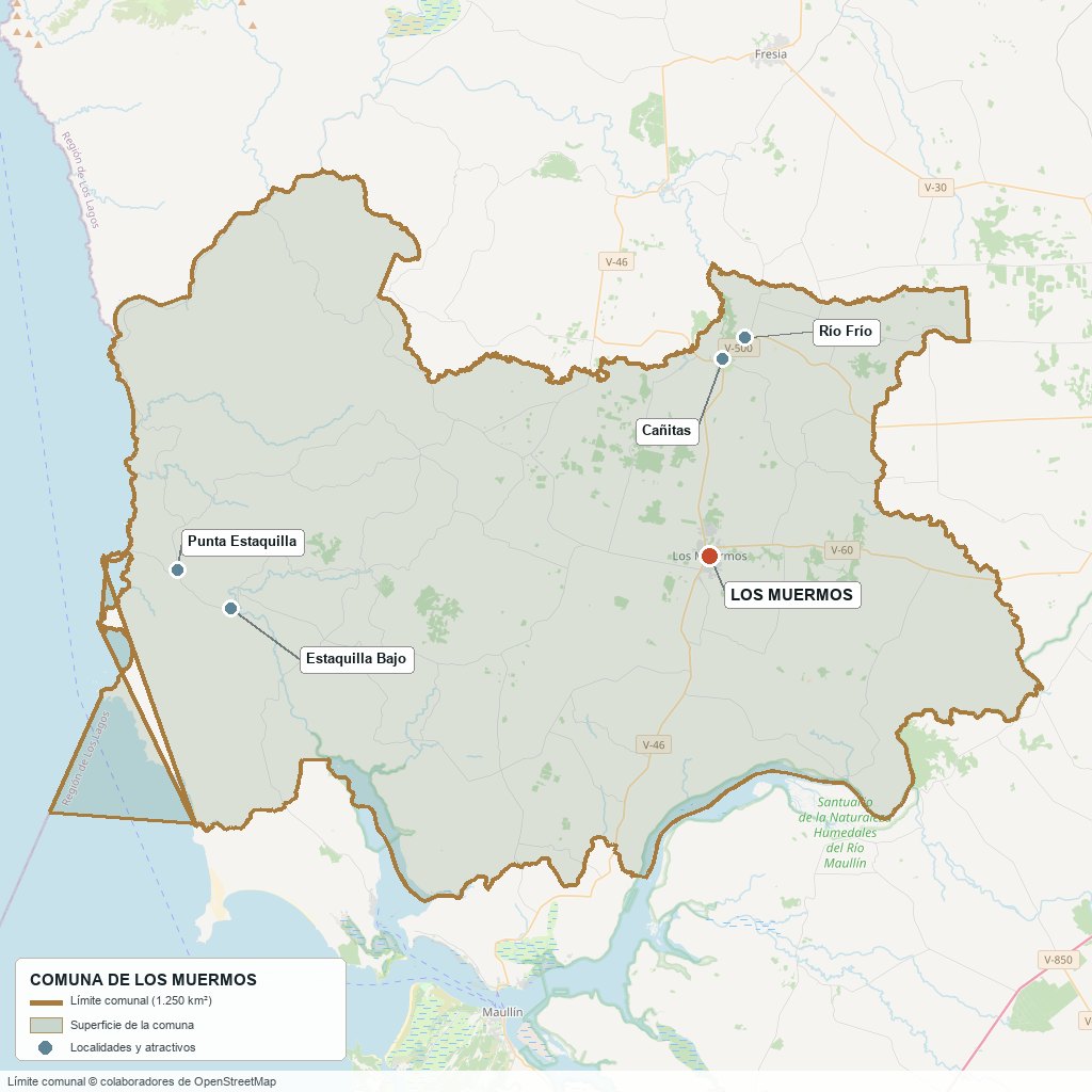
Commune boundary based on OpenStreetMap open data
§ 03 Location, Geography and Territory View
Where Los Muermos is, what it is built on and why its soil matters.
3.1 Location
The commune's capital lies in the central valley, between latitudes 41°15′ and 41°30′ south. It is not on Route 5: it is reached by road V-60, which links it with El Tepual airport and with Puerto Montt, about 47 km away. From the city, the Municipality records Cañitas at 10 km, Río Frío at 12 km, Palihue at 30 km, Estaquilla at 45 km and Hua-Huar at 54 km.
City of Los Muermos · 41°23′ S, 73°27′ W
3.2 Terrain and setting
The territory has two halves. The eastern one is a plain at roughly 100 to 200 m elevation where the city (elevation close to 150 m), Cañitas (81 m) and Río Frío (124 m) are located. The western half rises into the Cordillera de la Costa (Coastal Range), in the hills known as the Cordillera del Sarao, with peaks of about 500 m in the north-west. According to our own grid of 345 points on a digital elevation model, half of the commune lies below 115 m and only one in ten samples exceeds 300 m.
3.3 Hydrography
Main watercourses of the commune5 rows
| Watercourse | Role in the territory |
|---|---|
| Maullín River | Southern boundary with the commune of Maullín. The commune reaches as far as its north bank; the river neither crosses it nor rises in it. |
| Amancayes and Llico rivers | Natural northern boundary, as far as the sea (according to the Municipality). |
| Oscuro River | Natural eastern boundary (municipal description). |
| Cululil, Palihue, Ostiones and Guaguar | Watercourses listed by name within the commune polygon in OpenStreetMap; the Cululil and the Palihue give their names to census districts. |
| Maullín River Wetlands | Nature Sanctuary (Decree 2 of 2022) shared with Maullín, Llanquihue, Puerto Varas and Puerto Montt; managed by Maullín. |
3.4 Soils
According to the municipal PLADECO (Plan de Desarrollo Comunal, the commune development plan; an old document, from around 2006-2008), 44 % of the commune is trumao soil of volcanic ash and 40 % is metamorphic soil of the southern coast. Ñadis occupy 7 % (about 8,500 ha) and alluvial soils 1 %. Land-use capability comes from the 1975-76 study by INDAP (Chile's agricultural development institute): class VII, suited to forestry and livestock, covers 54,419 ha (43 %), and class III, suited to cultivation with limitations, 39,565 ha. There is no more recent verified soil survey.
- Advantage: trumao supports pasture and potatoes, the historic vocation of the valley.
- Limitation: the red clay soils of the coastal hills have severe limitations for cultivation; they suit forestry and extensive livestock farming.
- Risk: ñadi, with a hardened layer that blocks drainage, floods in winter; it should be visited between May and August and the water table checked.
- Real estate implication: two lots of the same size may be worth the same in the listing and perform differently depending on whether they lie on trumao, ñadi or hillside: soil is judged on site, not on the plan.
§ 04 Climate and Seasonality View
An oceanic climate with a long, rainy winter and a short, mild summer: water sets the calendar.
The commune has a temperate oceanic climate, Köppen classification Cfb. There are no 1991-2020 climate normals from a station inside it: the INIA Los Canelos station (DMC 410036) has operated within the commune since 2009, but the Dirección Meteorológica de Chile (DMC, the national weather service) does not publish normals for it. The figures in this section are those of El Tepual, about 30 km east of the city and outside the commune; on the coast, exposed to the Pacific, the climate is windier and wetter, although there are no verified figures to measure it.
Reference climate parameters (El Tepual, 1991-2020 normals)6 rows
| Parameter | Typical value | Comment |
|---|---|---|
| Mean annual temperature | 10.3 °C | January 14.3 °C and July 6.4 °C. |
| Mean maximum temperature | 20.0 °C in January | July, the coldest month, has a mean maximum of 10.2 °C. |
| Mean minimum temperature | 3.5 °C in July | Annual mean minimum of 6.2 °C. |
| Annual precipitation | 1,565.6 mm | June, the wettest month, 213.4 mm; February, the driest, 69.0 mm. |
| Average relative humidity | 85 % | Rises to 91 % in May and June. |
| Sunshine hours | 1,713 per year | 237 hours in January and 53 in June. |
Reference station: El Tepual (DMC), 1991-2020 normals. Between April and August 57 % of annual rainfall falls (in June, 213 mm), and February is the only month below 70 mm: water is plentiful in winter and scarce just when the soil needs it most.
The El Tepual normals show a trend toward less rain: 1,844.7 mm in 1931-1960, 1,802.5 mm in 1961-1990, 1,615.4 mm in 1981-2010 and 1,565.6 mm in 1991-2020. This coincides with the summer drought and the dry wells that residents describe.
§ 05 History: From the Alerceros to the Railway Branch Line View
A town with no founder and no founding charter, born of timber and of a railway line that did not reach where it was meant to.
-
Before the 19th century
Huilliches and cuncos
According to the Municipality, the central valley was inhabited by huilliches and the coast by cuncos. The commune is not among the population centers of the Spanish colony.
-
Late 19th century
The alerceros
Families arrive in search of alerce and build temporary logging hamlets. Stable settlement would come much later.
-
1914
The railway is decided
During the government of Ramón Barros Luco, a branch line is proposed from Río Negro to the banks of the Maullín, to improve communication with Chiloé.
-
1929
Construction begins
Works begin on the Corte Alto–Los Muermos branch line. The junction was fixed at Corte Alto, and not at Río Negro as had been planned; many workers followed the line from the north.
-
1933-34
The first residents
The Municipality dates the settlement of the first residents from 1933. In 1934 the Comité Pro-Adelanto (a local progress committee) is formed, and the Carabineros post and school No. 24 arrive.
-
1936-37
Chapel and schools
The first chapel is built, the origin of the San Pedro parish, and school No. 30 opens. According to the Plan Municipal de Cultura (municipal culture plan), the post office had already been operating since 1935.
-
1940
The train arrives
The branch line opens its last station at Los Muermos, around September 1940. The project to continue to Maullín was dropped; the town ends up at the end of the line.
-
1943
Civil Registry, fire brigades and football
The first Registro Civil (civil registry) office opens, and the Club Atlético Independiente and the fire companies are born.
-
1952-56
School, electricity and milk
In 1952 the Hermanas de la Caridad del Sagrado Corazón (Sisters of Charity of the Sacred Heart) arrive and the Ramón Ángel Jara liceo (secondary school) is founded. Electricity arrives in 1953 and in 1956 the Chiprodal dairy industry is established.
-
1960
The earthquake that barely touched it
The earthquake and tsunami of 22 May caused serious damage at Quenuir, today in the commune of Maullín. In Los Muermos the damage “was not significant”; the American Red Cross financed 36 homes in the población Minnesota.
-
1962
The commune is born
On 1 January the commune is constituted; for almost 50 years it had been a municipal delegation of Maullín. The legal instrument creating it is cited differently depending on the source, so only the date of constitution is given.
-
1960s-80s
Paved road, railway in retreat
The paving of roads V-60 and V-46 reduces use of the railway, which ends its operations in the 1980s. The old station warehouse is preserved, next to the municipal library.
-
2012-2022
A zoning plan that was not approved
The plan regulador (zoning plan) project begun in 2012 proposed an urban limit of 623.9 ha. On 11 August 2022 the Municipal Council suspended and ended the environmental procedure: the commune remained without a plan.
-
2022
Maullín Wetlands Nature Sanctuary
Decree 2 declares a wetland of about 8,100 ha, shared by five communes including Los Muermos, a nature sanctuary; it is managed by the Municipality of Maullín.
-
2025-2026
Two plans under way
In June 2025 the environmental assessment begins of an update to the zoning plan for Los Muermos, Cañitas and Río Frío; in August 2026 the Regional Government starts the Plan Regulador Intercomunal de Llanquihue (Llanquihue intercommunal zoning plan), which includes the commune.
§ 06 Cultural Identity and Indigenous Peoples View
In the 2002 Census, 393 people declared themselves as belonging to an indigenous people; in 2024, 2,698.
According to the 2024 Census, 15.7 % of the population declares belonging to an indigenous people (2,698 people), below the regional average (26.6 %) and above the national one (11.4 %). The series is striking: 393 people (2.3 %) in the 2002 Census, 2,753 (16.1 %) in 2017 and 2,698 in 2024. Almost all of the jump occurred between the first two censuses, and most of those who identify do so as Mapuche (15.4 % of the population in 2017).
The cultural strata of Los Muermos4 rows
| Tier | Visible traces today |
|---|---|
| Huilliche and cunco | According to the Plan Municipal de Cultura (municipal culture plan), Mapuche roots predominate in dress, food and rites. In 2019 the Municipality listed thirteen indigenous organizations, among them the Comunidad Newen Lafquen Mapu (Estaquilla), Huidaleo (Palihue), Lingai (Caracol) and the Asociación Newen (Cañitas). |
| Alerceros and railway people | The town was born of alerce extraction and of the railway line; the trades of the rail and of timber gave it its first society. Today the school museum and the Punta de Rieles themed plaza preserve that memory. |
| German influence in the architecture | There was no German colonization at the origin of the town (the Municipality and the Culture Plan say so expressly), but the heritage houses of Río Frío and Cañitas and the Río Frío church, from the 1930s, show this influence. |
| Recent arrivals | Those born outside the country were 0.4 % in 2017 and 2.1 % in 2024: according to the Servicio Nacional de Migraciones (national migration service), 365 foreign residents in 2024 compared with 72 in 2017. |
The mix is visible in the calendar: the Festival de Los Muermos and the twelve summer country festivals sit alongside the patron saint festivals, and the Plan Municipal de Cultura recognizes Mapuche roots in food, rites and dress. The name itself refers to a tree of the area, the muermo —a common name for the ulmo (Eucryphia cordifolia)—, although no municipal source documents that the town was named for that reason.
§ 07 Key Demographic Data View
7.1 Population and growth
Comparative demographic indicators11 rows
| Indicator | Commune | Region | Country |
|---|---|---|---|
| Population, 2017 Census | 17,068 | — | 17,574,003 |
| Population, 2024 Census | 17,162 | — | 18,480,432 |
| Intercensal change | +0.6 % | +7.4 % | +5.2 % |
| Commune area | 1,245.8 km² | — | — |
| Population density (2024) | 13.8 inhab./km² | — | — |
| Rural population (2024) | 54.1 % | 29.0 % | 13.3 % |
| Foreign-born population (2024) | 2.1 % | — | 8.7 % |
| Masculinity index (2024) | 100.9 | 96.5 | 94.3 |
| Older adult index (2024) | 106.9 | 75.8 | 79.0 |
| Demographic dependency index (2024) | 53.4 | — | 46.5 |
| Average schooling (2024) | 8.5 years | 9.8 years | 10.4 years |
7.2 Age structure (2024 Census)
Population distribution by age group5 rows
| Age group | Population 2024 | % Commune |
|---|---|---|
| 0 – 14 years | 2,883 (calculated) | 16.8 % |
| 15 – 29 years | 3,141 (calculated) | 18.3 % |
| 30 – 44 years | 3,244 (calculated) | 18.9 % |
| 45 – 64 years | 4,805 (calculated) | 28.0 % |
| 65 years and over | 3,087 | 18.0 % |
Los Muermos is aging without growing. The commune added 94 inhabitants between 2017 and 2024 (+0.6 %), against 7.4 % in the region, and its older adult index rose from 74.6 to 106.9: there are now more people aged 65 or over (3,087) than under 15. The masculinity index is balanced (100.9), above the regional (96.5) and national (94.3) figures.
The population is mostly rural: 9,278 people live in the countryside and 7,884 in urban areas. The city of Los Muermos lost inhabitants (8,106 in 2017 against 7,876 in 2024, −2.8 %), while the commune as a whole gained 94 inhabitants.
§ 08 Economic and Socioeconomic Data View
8.1 Poverty and social indicators (Casen 2024 and Registro Social de Hogares)
Comparative social indicators4 rows
| Indicator | Commune | Region | Country |
|---|---|---|---|
| Income poverty, Casen 2024 | 21.9 % | 16.5 % | 17.3 % |
| Multidimensional poverty, Casen 2024 | 24.4 % | 16.3 % | 17.7 % |
| People in households lacking basic services (RSH, June 2026) | 35.6 % | 22.8 % | 12.9 % |
| Population born outside the country, 2024 Census | 2.1 % | — | 8.7 % |
Casen 2024 (Chile's national household survey) uses a new methodology and is not comparable with 2022: the previous edition of the commune report showed 11.6 % income poverty and 29.2 % multidimensional poverty, and concluding from this that income poverty doubled would be a mistake. What can be read clearly is the relative position: Los Muermos is above the region and the country on both measures. The most revealing indicator is basic services: more than a third of people (35.6 %) live in households without complete basic services, compared with 22.8 % regionally. In a commune with a 54 % rural population, this points to water, sanitation and electricity.
8.2 Economic activity (SII) and municipal finances (SINIM)
Business structure and municipal finances10 rows
| Economic indicator (SII / SINIM) | Value |
|---|---|
| Registered businesses, 2024 | 1,733 (micro 1,188, small 237, medium 25, large 3, no sales 280) |
| Businesses in agriculture, livestock, forestry and fishing, 2024 | 685 (39.5 %); region 11.0 %; country 6.3 % |
| Dependent workers, 2024 | 2,382; in agriculture and livestock 600 (25.2 %; region 19.0 %) |
| Dependent workers by sector, 2024 | Commerce 420 · education 330 · public administration 313 · accommodation and food service 174 · construction 128 |
| Municipal revenue, 2025 | $6,863 million (≈ $385,000 per inhabitant) |
| Dependence on the Fondo Común Municipal (Municipal Common Fund), 2025 | 62.1 % of total revenue ($4,262 million); permanent own revenue 21.0 % |
| Municipal business licenses, 2025 | $119.6 million |
| Vehicle circulation permits, 2025 | $329.5 million |
| Property tax accruing to the municipality, 2025 | $516.2 million |
| Aquaculture licenses (Law 20,033), 2023-2025 | 0: aquaculture generates no fiscal revenue for the commune |
Almost two of every three pesos of the municipality's revenue come from the Fondo Común Municipal, that is, from redistribution from richer communes. The own revenue base is modest: commercial licenses total $120 million and municipal property tax $516 million. For a buyer, this matters because the municipality's ability to improve roads, rural water or services depends on transfers.
§ 09 The Productive Engine: Dairy, Potatoes and Artisanal Fishing View
The value of Los Muermos land rests on a small-scale agrarian economy, with no anchor agribusiness within the commune.
9.1 Dairy and livestock
The main activity is milk production, followed by cattle breeding and fattening, according to the municipal PLADECO (from around 2006-2008; no later verified instrument exists). That document counted some 100 cooling tanks and some 300 small producers, with five collection centers that shipped to plants in Llanquihue, Frutillar, Nueva Braunau and Valdivia. There is no dairy plant or livestock fair in the commune: cattle are sold at the fairs of Puerto Montt and Puerto Varas. In those years the commune held 1.85 % of the regional area and 3.58 % of its cattle.
Weight of agriculture: commune, region and country4 rows
| Indicator | Los Muermos | Region | Country |
|---|---|---|---|
| Businesses in agriculture and fishing as a share of the total (SII, 2024) | 39.5 % | 11.0 % | 6.3 % |
| Dependent workers in the sector as a share of the total (SII, 2024) | 25.2 % | 19.0 % | — |
| Employed in agriculture, livestock, hunting and forestry (2002 Census) | 42.8 % | 8.6 % | — |
| Commune's share of the region's area and livestock (PLADECO) | 1.85 % and 3.58 % | — | — |
The reading is of an agrarian commune by businesses and by tradition, but with a chain that closes outside it: milk and cattle leave unprocessed. This limits local added value and leaves producers exposed to the price paid by whichever plant is buying at the time, as well as to transport costs.
9.2 Potatoes and crops
The potato is the emblematic crop. In December 2023 the SAG (Servicio Agrícola y Ganadero, the agriculture and livestock service), when calling in Los Muermos for registration of potato plantings, described it as “a commune that stands out nationally for potato production”. Llanquihue Province has more than 3,000 producers and some 10,000 ha of potatoes according to the 2021 Agricultural Census. It was not possible to obtain the commune-level figures of that census, so they are omitted from this guide.
9.3 Other economic pillars
- Artisanal fishing and gathering on the coast: the Estaquilla cove had about 646 inhabitants and 34 boats (Plan Municipal de Cultura, 2019-2020), with loco fishing and port infrastructure delivered in October 2017. The PLADECO listed management areas and one aquaculture concession for molluscs; today the commune receives no aquaculture license revenue.
- Native forest and alerce: the 1997 diagnosis included in the PLADECO counted 47,390 ha of native forest, with alerce at Hua-Huar, Quillagua and Estaquilla. In 2023 residents reported deforestation caused by rural subdivisions and unregulated extraction of pompón (peat).
- Commerce and services: commerce employs 420 dependent workers, education 330 and public administration 313: education and public administration together account for more than a quarter of dependent jobs.
- Employment outside the commune: many residents work in Puerto Montt and travel daily. The PLADECO already warned of the risk of becoming a “dormitory town”.
§ 10 Real Estate Market View
10.1 Available properties and property types
Supply is almost entirely rural land. On Yapo (a Chilean classifieds portal; queried on 10 November 2026) the “lots and land” category for Los Muermos had 151 priced listings, of which 79 are parcels of between 4,500 and 6,500 m². Farms of more than 3 ha are less than a quarter, and there are only 5 listings in the “fincas” (farm estates) category. Produncan Lands markets more than ten properties within the commune boundaries.
10.2 Average price by property type (indicative, November 2026)
Indicative price ranges by property type (asking prices on Yapo, UF at $41,302)6 rows
| Property type | Indicative price range | Notes |
|---|---|---|
| Parcel of ~5,000 m² | Median 605 UF (≈ $25 MM); middle half 387-1,100 UF | 79 listings; full range 194-3,632 UF; about 1,160 UF/ha. |
| Lot of 0.65 to 3 ha | Median 605 UF (≈ $25 MM); range 266-1,675 UF | 11 listings, small sample. |
| Farm of 3 to 10 ha | Median 3,474 UF (≈ $143 MM); range 1,574-9,685 UF | 8 listings; about 450 UF/ha. |
| Farm of 10 to 50 ha | Median 5,992 UF (≈ $247 MM); range 278-19,176 UF | 10 listings; about 300 UF/ha. Those of 19 to 44 ha with pasture: 220-440 UF/ha. |
| Farm of more than 50 ha | Median of about 26,600 UF (≈ $1,100 MM); range 2,905-36,318 UF | 7 listings, very heterogeneous (about 170 UF/ha). |
| Coastal parcels with sea view or access | Between 360 and 2,050 UF | Those of ~5,000 m² at Estaquilla run around 360-1,200 UF; with a view or direct access to the sea they reach 1,650-2,050 UF. |
These are asking prices, not closing prices, and Yapo mixes old and recent listings with no visible date. In the same query, the ~5,000 m² parcel has a median of 532 UF in Fresia (35 listings) and 1,937 UF in Puerto Varas, 3.2 times higher than in Los Muermos (in the latter commune only 120 of 534 listings were reviewed, so it is not a random sample). That is, Los Muermos is much cheaper than Puerto Varas and somewhat more expensive than Fresia.
As for the cycle, applications to subdivide rural properties fell 62.4 % in the first half of 2025 compared with the same period of 2022 (Diario Financiero, 2025). The same report quotes experts who speak of the end of the parcel “boom”, of oversupply and of falling prices, in an adjustment of two to five years.
10.3 What determines the price in Los Muermos
Valuation factors in this market, ordered by the available local evidence5 rows
| Factor | Price impact | How to check it here |
|---|---|---|
| Sea view or access | Up to ~3 times the median (1,650-2,050 UF against 605) | Check on site whether access is direct or by easement (servidumbre); the Estaquilla coast is 45 km away and road V-510 is mixed, asphalt and gravel. |
| Distance and road to Puerto Montt | No measured differential | The V-60 is paved; areas served by the V-46 or the V-510 combine asphalt and gravel. Measure real travel times in winter. |
| Water: well and rights | No measured differential | The Regional Government's water dialogue (2023) reports wells running dry in summer. Ask for the flow measured in February and consult the Dirección General de Aguas (the national water authority). |
| Electricity feasibility | No measured differential | The distributor is CRELL (Cooperativa Rural Eléctrica Llanquihue, a rural electricity cooperative). Ask for a feasibility report and a formal grid-extension quotation before making an offer. |
| Soil drainage (ñadi) | No measured differential | Visit between May and August and check the water table and winter access; 7 % of the commune is ñadi. |
§ 11 Land-Use Planning in Los Muermos View
What the planning instrument of this commune permits and prohibits: strictly speaking, almost nothing, because there is none in force.
Los Muermos has no plan regulador comunal (PRC, the commune zoning plan) in force. The explanatory report (memoria) of the 2013 draft zoning plan, published on the Municipality's website, says so: there is no regulatory territorial plan in the commune, so the Ley General de Urbanismo y Construcciones (LGUC, the general urban planning and construction law) and its ordinance for rural areas apply throughout its territory. The only thing in force is an urban limit for the city of Los Muermos, set by Decree 253 of the Ministerio de Obras Públicas (Ministry of Public Works, 31 January 1963) and modified by Decree 1063 (13 August 1971), of about 170 ha. The report considers it “out of use” and calculates that the real consolidated area already exceeded it by 20 ha in 2013. Cañitas and Río Frío have no instrument in force.
Planning instruments affecting the commune4 rows
| Instrument | What it regulates | Status |
|---|---|---|
| 1963 urban limit (modified in 1971) | Only the city of Los Muermos (170 ha); it does not zone or set building standards. | In force, but outgrown by the real city. |
| 2012-2013 draft zoning plan | It proposed 623.9 urban ha: Los Muermos 511.1; Cañitas 69.0; Río Frío 43.8. | Never approved; the Municipal Council closed the procedure on 11 August 2022. |
| Zoning plan update | Preliminary draft for Los Muermos, Cañitas and Río Frío (does not include Estaquilla). | Environmental assessment started by Municipal Decree 1,197 (June 2025); no verified approval. |
| Plan Regulador Intercomunal de Llanquihue (intercommunal zoning plan) | Lake Llanquihue basin; the study area includes Los Muermos. | Started by Resolución Exenta 3867 of the Regional Government (11 August 2026): preparation 2026, design 2027-2029. |
The 2013 draft identified two types of risk within urban areas: zones prone to flooding from overflowing watercourses and waterlogging (30.1 ha in the city) and landslide zones (34.0 ha). The areas indicated were the east of the city, the south-west of Cañitas and the west of Río Frío. Because the draft was never approved, these areas are not regulatory, but they do indicate where flooding occurs.
Outside the urban limits —that is, across all of the countryside, the coast and Estaquilla— rural land rules apply. There is no heritage zone (zona típica) or declared national monument in the commune (Plan Municipal de Cultura, 2021); the protection that does exist is that of the Humedales del Río Maullín Nature Sanctuary (2022), shared with four other communes, and that of native forest (Law 20,283), which requires a management plan approved by CONAF (the national forestry corporation) before it can be intervened. No tsunami flood map was found for the coast.
§ 12 Neighbourhoods and Areas View
The commune is not organized into neighborhoods but into a center and a constellation of rural localities, each at a different distance and along a different road. The city holds 7,876 inhabitants; most of the rest live in hamlets and scattered areas. The 2017 Census showed seven rural census districts, the largest of which, Palihue, had 2,076 inhabitants.
Areas of the commune and their profile6 rows
| Sector | Features | Market profile |
|---|---|---|
| City of Los Muermos | Commune capital (7,876 inhabitants in 2024), in the central valley at about 150 m. Plaza de Armas (2011), cultural center, municipal library next to the old station warehouse, CESFAM (family health center) and bus terminal. | Urban lots and houses; the only area with an urban limit in force. |
| Cañitas | 10 km and 15 minutes from the city. Railway station from the 1930s, heritage houses, rural health post and police outpost. | No price sample of its own; rural subdivisions were already advancing toward here in 2013. |
| Río Frío | 12 km. Church from the 1930s with German influence; the census district had 1,385 inhabitants in 2017. Route V-50 connects it with Puerto Varas. | No price sample of its own. |
| Palihue, Cululil and Ostiones | Rural districts of the interior: Palihue 30 km, Cululil 28 km and Ostiones 19 km from the city. | Predominantly agricultural and livestock; no price sample of its own. |
| Cordillera del Sarao | Coastal hills to the north-west, with peaks of up to about 500 m and hillside soils. | No price sample of its own; no urban supply. |
| Estaquilla and the coast | Fishing cove 45 km away (1 hour), with wooden walkways and viewpoints. Hua-Huar, with dunes and a beach, is 54 km away. | 5,000 m² parcels between 360 and 1,200 UF; with a sea view or access, up to about 2,050 UF. |
§ 13 Basic Services, Utilities and Digital Connectivity View
Practical information that rarely appears in descriptions of a commune but that nonetheless determines whether any property is viable.
Service providers and coverage6 rows
| Service | Provider / operator | Practical notes |
|---|---|---|
| Electricity | CRELL (Cooperativa Rural Eléctrica Llanquihue); not Saesa | The CNE (Comisión Nacional de Energía, the national energy commission) lists it for Fresia, Los Muermos, Maullín and Puerto Octay. In April 2023 the SEC (Superintendencia de Electricidad y Combustibles, the electricity and fuels regulator) met with about 20 rural neighborhood councils over repeated outages and voltage drops; in April 2025 residents of Cañitas and Río Frío protested a prolonged outage. |
| Urban drinking water | ESSAL | Operates the city's plant. The coverage figures (98 % for water, 88 % for sewerage) are old, from around 2006. |
| Rural drinking water | APR committees and cooperatives | The 2021 listings of the MOP (Ministry of Public Works) mention the APR (rural drinking water) systems El Torreón and Ostiones (current status not verified). In the 2023 water dialogue, APR systems without sanitary approval were mentioned. |
| Sewerage | ESSAL in the city | The city's treatment plant discharges into the El Naranjo and Ñadi rivers (SMA, the environmental enforcement agency). Rural residents point to contamination of streams from APR septic tanks and from dairy farms. |
| Internet and phone | Movistar, WOM and others | The commune appears in the Movistar and Subtel (the telecommunications regulator) fiber-optic rollout in the southern macro-zone, and WOM reported a network in rural areas. Coverage per property is not verified: measure on site. |
| Household waste | Final disposal at the La Laja landfill (Puerto Varas) | The landfill serves nine communes. In October 2026 the Puerto Varas municipal council halted the expansion (cell 3); with cell 2 at 88.9 % occupancy in June 2026, without works there would be no disposal site from August 2027. The later outcome was not verified. |
§ 14 Health View
Los Muermos has no hospital: all medium- and high-complexity care takes place in Puerto Montt.
The commune belongs to the network of the Servicio de Salud Reloncaví (Reloncaví Health Service), and its primary care depends on the municipal Departamento de Salud (DESAM). According to the BCN's Reporte Comunal (July 2026), the commune has seven facilities: one family health center, one primary emergency care service and five rural health posts. The mayor himself said as much in 2017: “we only have a Cesfam”.
Health network in the commune5 rows
| Facility | Type | Detail |
|---|---|---|
| CESFAM Los Muermos | Family health center | Primary care for the city; in 2017 it had about 17,000 registered patients and did not handle births. |
| SAPU Los Muermos | Primary emergency care | Attached to the CESFAM. |
| Cañitas health post | Rural health post | About 10 km from the city; serves the Río Frío district. |
| Health posts at Estaquilla, Los Piques, Cumbre Alta and Quillagua | Rural health posts | Coverage of the interior and the coast. The replacement project for the Los Piques post appears in the Dirección de Presupuestos (the national budget office). |
| Municipal pharmacy and mobile support | Municipal programs | Includes a mobile dental clinic and a gynecology truck (DESAM). |
Those registered in primary care (20,521 in December 2025) exceed the census population (17,162), a common over-registration in the public system. No local SAMU (emergency medical service) base was verified: the nearest is in Frutillar.
§ 15 Education View
15.1 School education
In 2025 the commune had 3,847 students and 25 schools: 12 subsidized private and 13 dependent on the Servicio Local de Educación Pública (SLEP) Llanquihue, to which the municipal schools were transferred. No municipal schools remain. In 2011 there were 41 (26 municipal); the drop reflects closures and mergers of rural schools, so that year's list is not valid as a current list.
Notable schools4 rows
| Facility | Type | Distinction |
|---|---|---|
| Liceo Punta de Rieles | SLEP Llanquihue | City secondary school; in 2011 it offered humanities-science, administration and agricultural tracks. In July 2026 it received a cultivable yard (Patio Vivo program). |
| Colegio Ramón Ángel Jara | Subsidized private | Founded in 1952 by the Sisters of Charity of the Sacred Heart; it has the “Manuela Sánchez” School Museum (2011). |
| Colegio San Cristóbal | Not verified | Urban school; it had 317 students in 2011. |
| Escuela Los Ulmos | SLEP Llanquihue (was municipal in 2011) | Urban school with boarding facilities; 310 students in 2011. |
SIMCE 2025 results (preliminary)7 rows
| SIMCE test | Commune | Region | Country |
|---|---|---|---|
| Grade 4, reading | 276 | 275 | 276 |
| Grade 4, mathematics | 260 | 259 | 262 |
| Grade 8, reading | 224 | 236 | 238 |
| Grade 8, mathematics | 246 | 255 | 258 |
| Grade 8, history | 235 | 247 | 250 |
| Grade 10 (II medio), reading | 232 | 245 | 250 |
| Grade 10 (II medio), mathematics | 241 | 255 | 263 |
The pattern is clear: in grade 4 the commune is on a par with the country, but in grade 8 and grade 10 it falls between 9 and 14 points below the region (and up to 22 below the country, in grade 10 mathematics). The average schooling of the adult population, 8.5 years against 9.8 in the region, points in the same direction.
15.2 Higher education
No campus of a university, professional institute or technical training center was found in the commune. The PLADECO noted that those seeking higher education go to Puerto Montt, and it is reasonable to assume this is still so, although the current data is not verified.
§ 16 Pacific Coast and Natural Environment View
Los Muermos is not a commune of lakes or volcanoes: its natural setting is the Pacific. Almost 60 km of open coast, with rocky shores, dunes and a fishing cove, lie an hour from the commune capital and between an hour and a half and two hours from El Tepual airport (estimate from map).
Natural attractions by distance from the city of Los Muermos5 rows
| Attraction | Approx. distance | Activities |
|---|---|---|
| Estaquilla Cove | 45 km (1 h) | Wooden walkways with viewpoints over rocky shores and cliffs, loco fishing, seafood cuisine. Cold, rainy and windy weather even in summer. |
| Estaquilla Point | About 45 km | Headland with a Navy beacon (Directemar, the maritime authority) and a small hamlet. |
| Hua-Huar Beach | 54 km (1 h) | Dunes, beach and river near its mouth, with a view of the Cordillera de la Costa. |
| Cordillera del Sarao | About 17 km in a straight line, to the north-west | Coastal hills with native forest; peaks of up to about 500 m. |
| Maullín River Wetlands | Southern boundary of the commune | Nature Sanctuary shared with four other communes; 152 bird species and the huillín (river otter) among its fauna. |
Estaquilla coast and Cordillera del Sarao
As for protected areas, there are no national parks or national monuments within the commune. The Maullín River sanctuary is shared and managed by Maullín, so it should not be presented as an attraction of Los Muermos itself.
§ 17 Connectivity and Transportation View
17.1 Road network
Los Muermos is not on Route 5 South: its main access is road V-60, which is paved, passes El Tepual airport and reaches Puerto Montt and Route 5. The V-46 runs north to south, and the V-60 and V-510 east to west.
Routes and distances9 rows
| Route / destination | Distance and details |
|---|---|
| Route V-60 | Paved. Links the city with El Tepual and Puerto Montt and with Route 5 South. |
| Route V-46 | Asphalt and gravel. North toward Cañitas, Río Frío and Fresia; south toward Lolcura and Maullín. |
| Route V-50 | Paved. Links Cañitas and Río Frío; from there Puerto Varas is reached by an indirect road. |
| Route V-510 | Asphalt and gravel. Leads to Estaquilla and to Quenuir (the latter in the commune of Maullín). |
| Puerto Montt | About 48 km and 53 minutes (estimate from map; municipal sources: 47 km and between 45 and 60 min). |
| El Tepual Airport | About 35 km and 35 minutes. |
| Puerto Varas | About 49 km and 51 minutes. |
| Osorno | About 131 km and 1 hour 50 minutes. |
| Fresia and Maullín (other communes) | About 33 km (41 minutes) and 31 km (42 minutes). |
Between Puerto Montt, Osorno and the Pacific
The pavement condition of the V-46, V-50 and V-510 comes from a 2013 municipal study, so it must be verified with Vialidad (the roads directorate of the MOP) before deciding. In Cañitas and Río Frío only the V-46 and V-50 are paved: the internal streets are gravel or dirt.
17.2 El Tepual Airport
Puerto Montt's airport, El Tepual, lies in the commune of Puerto Montt, about 35 km from the city of Los Muermos and on the road that links it with Puerto Montt. It is the gateway airport for those arriving in the commune from other regions.
Airport terminal fact sheet4 rows
| Fact | Detail |
|---|---|
| Commune | Puerto Montt (does not belong to Los Muermos) |
| Distance from Los Muermos | About 35 km, about 35 minutes (estimate) |
| Distance to the center of Puerto Montt | About 16 to 17 km |
| Weather station | DMC code 410005; serves as the climate reference for the commune |
17.3 Road and urban transportation
- Bus terminal: there is a terminal in the city. In 2010, six companies served the route to Puerto Montt, with departures every 10 minutes on weekdays (99 daily); the fare rose from $2,000 to $2,500 in February 2025.
- Railway: the Corte Alto–Los Muermos branch line arrived in 1940 and ended its operations in the 1980s. There is no passenger service.
§ 18 Tourism: Development, Attractions and Things to Do View
18.1 Tourism development
In 2021 the Municipality commissioned a Tourism Development Plan, financed by the Subsecretaría de Desarrollo Regional (the regional development undersecretariat) ($16 million); the then mayor spoke of fishing, native forests and almost pristine beaches. The published document was not found. The appeal is mainly coastal, and the country festivals are concentrated in summer.
18.2 Tourist attractions in the commune
- Estaquilla Cove: wooden walkways with viewpoints over rocky shores, a waterfall and caves on the beach; the cove has port infrastructure delivered in 2017.
- Hua-Huar Beach: dunes, beach and river near the mouth, 54 km from the city.
- Cañitas and Río Frío: heritage houses from the 1930s, used as hotels and inns, and the Río Frío church, built with donations from residents whose names are engraved on the pews.
- Punta de Rieles themed plaza (2016): a tribute to the railway station, next to the old warehouse.
18.3 Museums and culture
- “Manuela Sánchez” School Museum (2011): at the Colegio Ramón Ángel Jara; it tells the story of the railway and of the Sacred Heart sisters. It received about 500 visitors in 2019.
- Cultural Center: opened in 1998 and expanded in 2010, next to the Plaza de Armas (2011).
- Municipal Library: opened in 2013, next to the old station warehouse (Bernardo O'Higgins street).
18.4 Food and dining
The cuisine blends the sea of Estaquilla with the vegetable gardens and pastures of the valley. Dishes from the cove include chupe de loco (a loco stew) and caldillo de mariscos (seafood broth); in the valley, the potato has its own festival, “Rayando la Papa”.
- Asado Muermino: a festival born in 2013, held in late January in the Plaza de Armas; it drew more than 12,000 attendees in 2019.
- Loco of Estaquilla: the harvest season starts in March and lasts about six months; the Fiesta del Loco is held in July, organized by the fishermen's union (2022 date).
18.5 Nature and the outdoors nearby
- Estaquilla and Hua-Huar coast: coastal walks, dunes and sea watching.
- Cordillera del Sarao: coastal hills with native forest, harder to reach.
- Maullín River wetlands: bird watching on the southern boundary, an area shared with Maullín.
18.6 Calendar of events and traditions
Main events of the year7 rows
| Period | Event | Character |
|---|---|---|
| 20 January | San Sebastián | Religious festival at Ostiones Paredes and Cumbre Alta. |
| Late January | Asado Muermino | Two days in the Plaza de Armas since 2013. |
| First week of February | Festival Los Muermos | Five days, since 2019; it evolved from the Semana Muermina. The Culture Plan estimated about 40,000 people in 2019. |
| Summer | Country festivals (fiestas costumbristas) | About twelve in rural localities: Paraguay Chico, Estaquilla Bajo, San Carlos-El Ñadi, Cañitas, Quillahua and others. |
| 16 June and 16 July | Sagrado Corazón (Sacred Heart) and Virgen del Carmen | Religious festivals in the city and at Ostiones Velásquez. |
| July | Fiesta del Loco | At Estaquilla, organized by the fishermen's union (2022 data). |
| 6 October | San Francisco de Asís (Saint Francis of Assisi) | Patron saint festival at Palihue. |
§ 19 Everyday Life, Sport and Practical Information View
What anyone who will live in Los Muermos, and not just visit it, needs to know.
19.1 Sport and identity
- Club Atlético Independiente (CAI): founded in 1943, the same year as the Civil Registry and the fire brigades; it is the city's historic club.
- Club de Leones (Lions Club): since 1963, among the oldest civic institutions of the town.
19.2 Shopping and supplies
The city covers everyday needs: in 2024 there were 404 commerce businesses and 120 transport businesses. For what is missing —higher education, hospital, large stores, major paperwork— the reference city is Puerto Montt, about 50 minutes away.
19.3 Where to handle paperwork
Services based in Los Muermos4 rows
| Office | Address or contact | Remarks |
|---|---|---|
| Health Department (DESAM) | Telephone 65 2 211716 | Runs the CESFAM, the SAPU and the rural health posts. |
| Municipal Library | Bernardo O'Higgins street, next to the old station warehouse | Home of the city's cultural activities. |
| Bus terminal | City of Los Muermos | Frequent service to Puerto Montt (2010 data). |
| Carabineros and fire brigades | Police station (tenencia) in the city; outposts at Cañitas and Paraguay Chico | 2013 data: check that it is still current with each institution. |
19.4 Cost of living and practical considerations
- The bus fare to Puerto Montt has been $2,500 since February 2025; for those who travel daily, it is a significant fixed expense.
- On rural parcels, a backup power supply (generator or panels) and a well with a proven flow are part of the real cost, not an extra.
- For more complex health care, higher education and large purchases, the cost and time of the trip to Puerto Montt must be taken into account.
§ 20 Territorial Analysis: Strengths, Challenges and Opportunities View
An honest reading of the territory. A sound investment decision also requires knowing what doesn't work.
- Rooted agriculture: 39.5 % of businesses are agricultural (region 11.0 %) and the potato gives the commune national fame according to the SAG.
- Paved access to Puerto Montt along the V-60, 47 km away, with frequent bus service.
- Low entry price: the ~5,000 m² parcel has a median of 605 UF, against 1,937 UF in Puerto Varas.
- Almost 60 km of open coast and a cove with port infrastructure since 2017.
- Population almost stagnant (+0.6 % since 2017) and aging: 106.9 older adults per 100 people under 15; the city lost 2.8 % of its population.
- Poverty higher than the region (21.9 % income and 24.4 % multidimensional) and 35.6 % of people in households without complete basic services.
- No hospital or higher education campus; SIMCE results in grade 8 and grade 10 between 9 and 14 points below the region.
- No zoning plan in force: everything is governed by rural land rules except an urban limit from 1963.
- 62 % of municipal revenue comes from the Fondo Común Municipal.
- Two plans under way, the zoning plan update and the new Llanquihue intercommunal plan (2026-2029), may provide regulatory certainty.
- The parcel market is adjusting downward (-62.4 % in subdivision applications): a buying window for those who arrive with the analysis done.
- Fiber-optic rollout in the southern macro-zone, key for remote work on parcels.
- Arrival of foreign population (365 residents in 2024 against 72 in 2017) and coastal tourism based at Estaquilla.
- La Laja landfill: without expansion, the nine communes that use it would be left with no disposal site from August 2027.
- Drought and dry wells, with groundwater that residents believe is contaminated by rural subdivisions.
- Outages and voltage drops in rural electricity service (CRELL).
- Legal changes in rural subdivision: stricter SAG criteria, a fine of up to 200 % of the assessed value for irregular subdivision and a rural life bill.
- Winter waterlogging on ñadis and on the plains of rivers and streams.
Los Muermos: Territory, Connectivity and Opportunities
Los Muermos is today an entry-level territory: land considerably cheaper than in Puerto Varas, a paved route to Puerto Montt and an almost untouched coast. But it is also unzoned land, with services still to be resolved and a regulatory framework that will change in the coming years. The opportunity exists for those who buy informed: well flow measured in summer, electrical feasibility in writing, a subdivision certificate and a winter visit.
At Produncan Lands we know this territory and its opportunities. Our work is to connect properties with people looking to invest, live and develop new projects in southern Chile, offering our experience, local knowledge and commercial reach.
We invite you to get to know our properties in Los Muermos and across southern Chile, and to entrust Produncan Lands with the sale of your property.
View properties at Produncan Lands§ 22 Sources and Methodology Note View
22.1 Sources consulted
Documents and sources used13 rows
22.2 Methodology note and data currency
- Casen 2024 uses a new methodology: its poverty figures are not comparable with those of Casen 2022. SIMCE 2025 is preliminary. The figures of the BCN Reporte Comunal were checked against the official page on 10 November 2026.
- The PLADECO (around 2006-2008), the study of facilities and road capacity (2013) and the land-use capability study (INDAP, 1975-76) are old documents: they are used only where there is no more recent data, and this is indicated.
- Left out because they could not be verified: the 2021 Agricultural Census by commune, the assessed fiscal value per hectare, the costs of extending the electricity grid and of a well, local higher education, the 2024 population by locality, and the commune's own climate normals.
- Road distances and times are estimates based on OpenStreetMap, not official figures. Elevation is our own calculation on a digital elevation model.
- The price ranges for the real estate market are indicative and do not constitute an appraisal: they are asking prices in listings, and some listings labeled “Los Muermos” correspond to areas of neighboring communes. Each property must be assessed individually.
- This document does not constitute legal or tax advice.
- Closing date of this edition: November 2026. It is recommended to review the indicators in sections 7, 8 and 10 annually, as well as the progress of the zoning plan and the intercommunal plan (section 11).
Territorial reference document prepared by Produncan Lands. It brings together official information (INE, BCN, SII, SINIM, MINEDUC, DMC, MINSAL) with local market knowledge, so that anyone —resident, visitor, investor or buyer— can understand Los Muermos in depth before making a decision.