
OsornoLand of lakes and roots
The Green Gateway to Southern Chile — History, Nature and Investment Opportunities
LAND OF RAIN AND ROOTS
Osorno was born where the Rahue and the Damas rivers seek each other out in the rain, on a fertile plain the Huilliche people called home long before any fort bore the name of a queen. Here the land was destroyed and founded anew, and that refounding left behind a character tempered by sheer persistence: the same one brought by the German settlers with their gabled roofs, their bakeries and their language, blended with the sound of the trutruka horns and the lowing of cattle in the paddocks.
It is a city of rodeo and gentle rain, of heritage houses along calle Mackenna and a river that crosses it unhurriedly. It is a threshold: to the east begin the volcanoes and lakes that maps can barely name —Puyehue, Rupanco, Llanquihue— and, toward the Andes, the road once crossed by muleteers and now by travelers, heading for a Patagonia that in truth begins right here, on this cattle-raising plain where southern Chile catches its breath before turning definitively wild.
Osorno does not announce itself: it reveals itself slowly, in the smell of homemade bread, in the mosaic of the twelve apostles gazing out from the Cathedral, in the bronze bull that watches over the square, and in the quiet certainty of those who live looking toward the volcano, knowing that water —rain, river or lake— always ends up shaping the character of this land.
Version 3.0 · Revised edition · August 2026
The Commune at a Glance
Osorno's essential facts at a glance. Each figure is explained in detail in the corresponding section.
Administrative identification and reference data12 rows
| Fact | Detail |
|---|---|
| Official name | Commune of Osorno (city of San Mateo de Osorno) |
| Region / Province | Los Lagos Region / Osorno Province (provincial capital) |
| Demonym | Osornino / osornina |
| Civic center coordinates | 40°34'21"S — 73°08'07"W |
| Area | 951.3 km² |
| Elevation | ≈35 m above sea level |
| Dialing code | +56 64 |
| Postal code | 5290000 |
| Time zone | UTC−4 (CLT) / UTC−3 in summer time (CLST) |
| Climate classification | Cfb — temperate oceanic, with no marked dry season |
| City anniversary | 27 March (founding, 1558) |
| Municipality | Ilustre Municipalidad de Osorno (Osorno Municipal Government) · municipalidadosorno.cl |
Overview
Osorno is the capital city of Osorno Province, in the Los Lagos Region of southern Chile. Founded in 1558 and refounded in 1793, its identity blends Huilliche, Spanish and 19th-century German colonization heritage, visible in its architecture, its cuisine and its family names. The commune covers an area of 951 km² and sits on the banks of the Rahue and Damas rivers, between the lake districts of northern Chilean Patagonia and the bi-oceanic corridor to Argentina.
Osorno serves as the agricultural and commercial service hub for the northern Los Lagos Region, and as the land and air gateway to Lakes Puyehue, Rupanco and Llanquihue, as well as to the Cardenal Samoré border crossing into San Carlos de Bariloche, Argentina.
Unlike neighboring tourist destinations such as Puerto Varas or Frutillar, whose economies revolve around visitors, Osorno is a productive city: its economic base is livestock, dairy farming, the food industry and wholesale trade. That condition defines its character —less scenic, more functional— and also its real estate logic, where land is valued as much for its productive capacity as for its view.
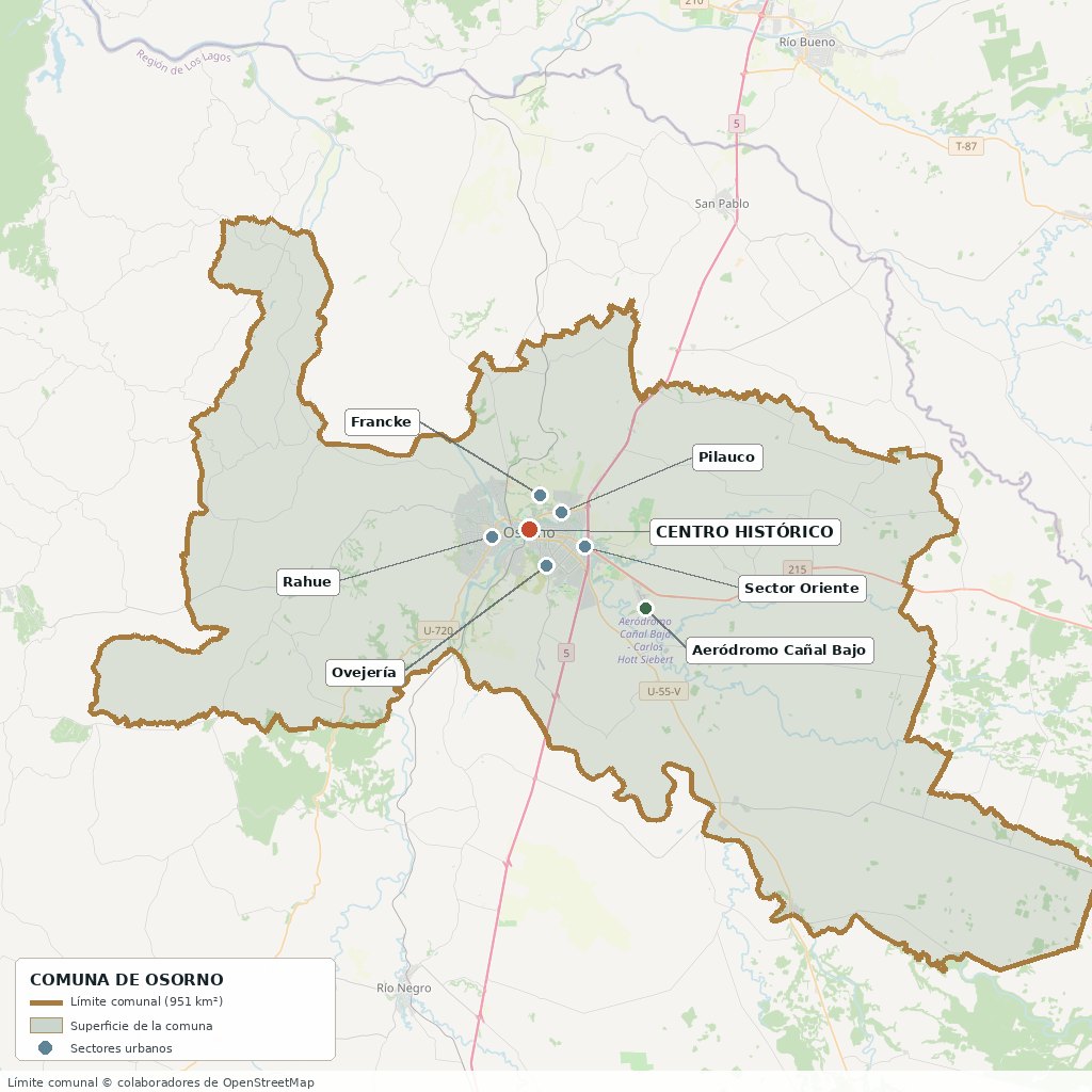
Communal boundary based on OpenStreetMap open data
§ 03 Location, Geography and Territory View
Where Osorno is, what it is built on, and why its soil matters.
3.1 Location
Osorno lies 917.8 km south of Santiago along Ruta 5 Sur, between the regional capitals of Valdivia (109 km to the north) and Puerto Montt (approximately 110 km to the south). Reference coordinates for the civic center: 40°34'21"S, 73°08'07"W.
Osorno civic center · 40°34'21"S 73°08'07"W
3.2 Terrain and setting
The commune lies within the Intermediate Depression, the central plain the Spanish knew as the Llanos de Osorno and the Huilliche as the levo of Chauracáví. The city is built on Quaternary river terraces carved by the Rahue River, which explains its characteristic internal changes in level —especially between the historic center and the Rahue sector, west of the river.
The communal territory stretches from west to east, from the edge of the Coastal Range to the central plain, with an average elevation of about 35 meters above sea level in the urban area. To the east, beyond the communal limits, the terrain rises quickly toward the Andean foothills, the lakes and the Puyehue-Cordón Caulle volcanic complex.
3.3 Hydrography
Main bodies of water in the commune4 rows
| Watercourse | Role in the territory |
|---|---|
| Rahue River | The main river axis. It crosses the city from south to north, separates the center from the Rahue sector and drains the waters of Lake Rupanco. Historically called the río de Las Canoas (River of the Canoes). |
| Damas River | A tributary that runs through the northern part of the urban area. The 1793 refounding took place between the Rahue and the Damas. |
| Bueno River | The natural northern limit of the basin; it receives the Rahue downstream and flows into the Pacific. |
| Minor streams | Pichi Damas, Chaura and other smaller watercourses that cross peri-urban sectors and affect the feasibility of subdivisions. |
3.4 Soils: the silent asset
The commune's dominant soils are trumaos —soils of volcanic origin derived from recent ash, deep, well-drained and with a high capacity to retain moisture. They are the physical reason this area is Chile's main dairy basin: they support high-yield permanent pastures with relatively low investment.
- Advantage: excellent suitability for pasture, oats, wheat, potatoes and small fruits; good natural drainage.
- Limitation: natural acidity and high phosphorus fixation, which require liming and sustained phosphate fertilization.
- Risk: areas with ñadi soils (thin soils over an impermeable iron pan) have poor winter drainage and are less suitable for building.
- Real estate implication: two adjoining parcels can have very different land-use capacities. Always request an agrological study or, at the very least, a test pit before buying a farm (fundo).
§ 04 Climate and Seasonality View
Osorno is defined by water. Understanding its rainfall pattern means understanding its landscape, its agriculture and its way of life.
Osorno has a rainy temperate oceanic climate (Cfb in the Köppen classification), with a Mediterranean influence: rainfall throughout the year but strongly concentrated in winter, short and cool summers, and cold, damp winters without persistent snowfall on the plain. The mean annual temperature is around 10.5 to 11 °C.
Reference climate parameters10 rows
| Parameter | Typical value | Comment |
|---|---|---|
| Mean annual temperature | 10.5 – 11 °C | Very stable from year to year |
| Summer average (Jan-Feb) | ≈14 – 15 °C | Highs of 22-25 °C; extremes above 30 °C are exceptional |
| Winter average (Jun-Jul) | ≈5 – 7 °C | Lows around 3 °C; frequent frosts on the plain |
| Annual precipitation | ≈1,100 – 1,400 mm | Varies by weather station and year |
| Wettest month | June | ≈170-180 mm |
| Driest month | January | ≈25-30 mm |
| Rainy days (August) | ≈20-22 days | Annual maximum |
| Relative humidity (Jun-Jul) | ≈91 % | Lowest in January, ≈74 % |
| Annual sunshine | ≈2,100 hours | January is the sunniest month |
| Snow in the urban area | Occasional, not persistent | Snow is common in Antillanca and the foothills |
June receives six times more water than January. That curve —not temperature— is what defines the landscape, the pastures and the way people build in Osorno.
The most significant medium-term phenomenon is the megadrought and increasing variability: although southern Chile still has a water surplus, drier and longer summers have been observed, which has begun to make access to a well or water rights relevant even in historically wet areas.
§ 05 History: Four and a Half Centuries on a Timeline View
Osorno is one of the few cities in Chile that was founded, destroyed and founded again. That cycle explains its character.
-
Pre-1553
Chauracáví
The plain between the Rahue and Damas rivers is inhabited by Huilliche communities, whom the Spanish would call 'chauracagüines'. Social organization is structured into levos (lineage-based territorial units) and chiefdoms.
-
1553
First Spanish attempt
Under the governorship of Pedro de Valdivia, an attempt is made to found a settlement named Santa María de Gaete, in honor of his wife. The attempt fails.
-
1558
Founding of San Mateo de Osorno
On 27 March, Governor García Hurtado de Mendoza founds the city under the name San Mateo de Osorno, in honor of his grandfather, the Count of Osorno (Palencia, Spain). A classic grid plan is laid out around a central Plaza de Armas.
-
1567–1598
Colonial boom
Osorno becomes a supply center for Valdivia and Villarrica and a link to Castro. Its open land and the area's gold washing sites make it one of the most prosperous cities in the south.
-
1598–1604
Destruction
After the disaster of Curalaba and the great Mapuche-Huilliche uprising, the city is besieged and finally abandoned. For almost two centuries the plain returns to the control of the Huilliche chiefs, and the Spanish lose track of the exact location of the ruins.
-
1792
Rediscovery of the ruins
On 22 November, Captain Tomás de Figueroa takes possession of the ruins of the old city, following a military campaign ordered by Governor Ambrosio O'Higgins.
-
1793
Parliament and Treaty of Las Canoas
On 8 September, on the banks of the río de Las Canoas (today's Rahue), a parliament is held between Spanish authorities and Huilliche chiefs. Under the agreement, the communities cede the land between the Rahue and the Damas for the rebuilding of the city. Construction of the Fuerte Reina Luisa begins.
-
1796
Official resettlement
The city is officially declared resettled and is annexed to the Intendancy of Concepción, separating from the Government of Chiloé. Ambrosio O'Higgins receives the title of Marquis of Osorno.
-
1850–1900
German colonization
German families settle in Osorno and its surroundings as part of the Chilean State's colonization policy. They introduce farming and livestock techniques, mills, tanneries, breweries and a distinctive architecture of gabled roofs. Family names and a mixed culture unique in the country take root.
-
1895
Arrival of the railway
The rail connection integrates Osorno into the national market and consolidates its role as a livestock and agricultural trading center.
-
1945
Feria de Osorno is born
The company that would become the leading livestock auction and beef export business in southern Chile is founded, a milestone for the local agricultural establishment.
-
1960
Valdivia earthquake
The largest earthquake ever recorded (Mw 9.5) severely damages the city's infrastructure, including the hospital. The reconstruction shapes Osorno's modern appearance, including the current Catedral San Mateo.
-
1974–1993
Modern institutions
The current Hospital Base San José opens (1974). In 1993 the Universidad de Los Lagos is created, successor to the Instituto Profesional de Osorno, with its main campus in the city.
-
2007
New Los Lagos Region
With the creation of the Los Ríos Region, Osorno becomes the northernmost major city in the Los Lagos Region, strengthening its role as provincial capital and hinge between the two regions.
-
2007–today
The Pilauco Site
Excavations at the Pilauco Site, right in the middle of the urban fabric, reveal remains of Pleistocene megafauna and evidence of early human presence more than 12,000 years old, placing Osorno at the center of the international scientific debate on the peopling of the Americas.
§ 06 Cultural Identity and Indigenous Peoples View
Almost a third of the commune's population belongs to an Indigenous people. It is one of the features that most sets Osorno apart from other mid-sized Chilean cities.
According to the Registro Social de Hogares (Social Household Registry, March 2025), 29.4 % of Osorno's population belongs to Indigenous peoples, a figure well above the national average (9.2 %) and even the regional one (26.0 %). Most identify as Mapuche-Huilliche, the people who inhabited the plains before the Spanish founding and who never ceased to be present in the territory.
Osorno's three cultural layers3 rows
| Tier | Visible traces today |
|---|---|
| Huilliche | Place names (Rahue, Chauracáví, Pilauco, Manquemapu, Cancura, Tacamó); active Indigenous communities in rural and coastal areas; ceremonies such as the nguillatún; a cuisine of mote, catuto, changles and digüeñes; their own institutions through the Council of Chiefs of Osorno (Fútawillimapu). |
| Spanish colonial | The grid layout of the center; Fuerte Reina María Luisa; street names and saints' names; the city's title as San Mateo de Osorno; the layout of the Plaza de Armas as the civic heart. |
| German (19th c.) | Architecture of gabled roofs and wooden shingles on calle Mackenna; family names (Stückrath, Hollstein, Bühler, Schilling); pastry shops and kuchen; breweries; the Instituto Alemán; the Club Alemán; the German Cemetery; a culture of methodical agricultural work that transformed the regional dairy industry. |
The coexistence of these three layers —not always harmonious, always present— is why Osorno's cuisine, architecture and even its way of speaking are unmistakable: on a single block you may find a German pastry shop, a market stall selling seafood from the Huilliche coast and a Republican-era building.
§ 07 Key Demographic Data View
7.1 Population and growth
Demographic indicators compared9 rows
| Indicator | Osorno commune | Los Lagos Region | Country |
|---|---|---|---|
| Population, 2017 Census | 161,460 | 828,708 | 17,574,003 |
| Population, 2024 Census | 166,455 | 890,284 | 18,480,432 |
| Intercensal change | 3.1 % | 7.4 % | 5.2 % |
| Commune area | 951 km² | — | — |
| Population density (2024) | ≈175 inhab./km² | — | — |
| Foreign-born population | 2.3 % | 4.0 % | 8.7 % |
| Sex ratio 2024 | 91.4 | 96.5 | 94.3 |
| Demographic Dependency Ratio (IDD) 2024 | 46.1 | 45.3 | 46.5 |
| Elderly Index (IAM) 2024 | 84.8 | 75.8 | 79.0 |
7.2 Age structure (2024 Census)
Population distribution by age group5 rows
| Age group | Population 2024 | % Commune |
|---|---|---|
| 0 to 14 years | 28,432 | 17.1 % |
| 15 to 29 years | 34,153 | 20.5 % |
| 30 to 44 years | 37,336 | 22.4 % |
| 45 to 64 years | 42,410 | 25.5 % |
| 65 years and over | 24,124 | 14.5 % |
Population aging is the commune's most pronounced demographic trend: the Aging Index rose from 57.7 in 2017 to 84.8 in 2024, above the national (79.0) and regional (75.8) averages. This means a growing proportion of people aged 60 or over relative to those under 15, with direct implications for demand for health services and for the profile of home buyers (more oriented toward first and second homes for older adults).
In terms of territorial distribution, the commune is predominantly urban: the city of Osorno is home to the vast majority of the population, while a dispersed rural sector, devoted mainly to farming and livestock, occupies much of the commune's 951 km².
§ 08 Economic and Socioeconomic Data View
8.1 Poverty and social indicators (CASEN and Social Household Registry)
Social indicators compared6 rows
| Indicator | Osorno commune | Los Lagos Region | Country |
|---|---|---|---|
| Income poverty, Casen 2022 | 6.2 % | 7.0 % | 6.5 % |
| Multidimensional poverty, Casen 2022 | 14.2 % | 19.7 % | 16.9 % |
| People in households lacking basic services (Mar. 2025) | 9.9 % | 23.1 % | 13.1 % |
| Overcrowded households (Mar. 2025) | 7.4 % | 7.5 % | 8.1 % |
| Indigenous population (RSH, Mar. 2025) | 29.4 % | 26.0 % | 9.2 % |
| Foreign population (RSH, Mar. 2025) | 1.5 % | 2.3 % | 6.7 % |
Osorno has income and multidimensional poverty rates below the regional average and, in the case of multidimensional poverty, below the national average as well. Particularly notable is the low percentage of households lacking basic services (9.9 %) compared with 23.1 % regionally, reflecting more established drinking water, electricity and sanitation coverage than in neighboring rural communes.
8.2 Economic activity (SII) and municipal finances (SINIM)
Business structure and municipal finances11 rows
| Economic indicator (SII / SINIM) | Value |
|---|---|
| No. of active businesses by size, commune (2023) | 12,412 |
| · Micro-enterprises | 9,471 |
| · Small companies | 2,512 |
| · Medium-sized companies | 298 |
| · Large companies | 131 |
| Reported salaried employees (2023) | 70,627 |
| Main sector by No. of businesses | Wholesale and retail trade (4,353 businesses) |
| Other relevant sectors | Transport and storage (1,672); Construction (1,623); Manufacturing (1,356); Agriculture, livestock and forestry (1,296) |
| Dependence on the Municipal Common Fund (FCM) as a share of total revenue, 2024 | 30.8 % |
| Permanent own-source revenue (IPP) as a share of total revenue, 2024 | 50.2 % |
| Total municipal revenue received, 2024 | $49,007,064 (thousands of $) |
Osorno's business structure is dominated by micro-enterprises (more than 60 % of the total), and the trade, transport, construction and agriculture sectors account for the largest number of economic units. Dependence on the Municipal Common Fund (30.8 % of total revenue in 2024) is moderate: slightly less than a third of the municipal budget comes from this solidarity fund, while more than half (50.2 %) consists of permanent own-source revenue, indicating a relatively healthy level of financial autonomy compared with communes that depend more heavily on the FCM.
§ 09 The Productive Engine: The Agri-Food Cluster View
Osorno is not a service city that just happens to be surrounded by countryside. It is a city built on the countryside. This section explains the business that sustains the territory.
9.1 Dairy: the country's third-largest commune
According to the Dairy Sector Indicators 2024 prepared by ODEPA and the Dairy Information Center, Osorno is the third commune in Chile for milk intake, with approximately 219 million liters per year, behind Río Bueno (309 million) and Puerto Octay (227 million). The commune has around 180 producers supplying the major processors.
National ranking of communes by milk intake (major processors, 2024)3 rows
| Rank | Commune | Annual intake |
|---|---|---|
| 1° | Río Bueno (Los Ríos Region) | ≈309.2 million liters |
| 2° | Puerto Octay (Los Lagos Region) | ≈227.3 million liters |
| 3° | Osorno (Los Lagos Region) | ≈219.3 million liters |
Nationally, the Los Lagos and Los Ríos regions account for about 90 % of the country's dairy suppliers. The commune is home to the Nestlé Cancura plant, one of the most modern powdered milk plants in South America, with a capacity of more than 30,000 tons per year and an intake of between 200 and 300 million liters depending on the product mix, supplied by more than 300 local producers and exporting to Peru, Central America, the Middle East and Asia. Prolesur (Soprole group) and Watt's also operate in the province.
9.2 Beef and livestock auctions
Osorno is the historic livestock marketplace of southern Chile. Grupo Feria de Osorno S.A., founded in 1945, brings together Fegosa (livestock auctions, with more than 70 % of the regional market), Frigosorno (slaughtering and beef exports) and Ferosor (farm supplies), as well as Ganadera Osorno. The commune is also home to the sheep genetics and production center of Tattersall Ganado, the country's largest auction network.
9.3 Other economic pillars
- Crop farming: oats, wheat, potatoes and sugar beet, with high yields thanks to the trumao soils and good water availability.
- Food industry: in addition to dairy and meat, flour milling, cured meats, craft brewing and berry agribusiness.
- Wholesale and retail trade: Osorno supplies the province's seven communes and part of Ranco Province; it is home to 4,353 trading businesses.
- Agricultural services: veterinary care, genetics, machinery, irrigation, technical advice, milk and livestock transport.
- Forestry: eucalyptus and pine plantations in the Coastal Range, alongside native forest protected under Law 20,283.
- Tourism: growing but still secondary within the commune, whose main role is as a service platform (see section 18).
§ 10 Real Estate Market View
10.1 Available properties and property types
Osorno's market offers a diversified supply: new and resale apartments in the center and eastern sector, urban houses in every part of the city, 5,000 m² rural parcels in the peri-urban ring (Pichi Damas, Tacamó, Chapaco Alto, Río Negro, Hacienda Pilauco), subdivisions with approved projects and direct developer financing, and larger farming and livestock properties. The main portals for tracking current availability are Portalinmobiliario, Chilepropiedades, icasas.cl, Economicos.cl (El Mercurio) and PortalTerreno.
10.2 Average price by property type (indicative, 2026)
Indicative price ranges by property type5 rows
| Property type | Indicative price range | Notes |
|---|---|---|
| Apartments (40-60 m²) | UF 3,000 to UF 7,600 | Central and eastern sectors; 1 to 3 bedrooms |
| Urban houses | $68,000,000 to UF 7,100+ | Depending on size, sector and age |
| Rural parcels (5,000 m²) | UF 2,000 to UF 10,000 | Varies greatly depending on access to water, electricity and distance to the city |
| New subdivisions and parcel projects | From $11,990,000 | Projects with direct developer financing; off-plan delivery |
| Farming/livestock properties | Depending on hectares and irrigation | Less liquid market, valued per hectare |
10.3 What determines the price of a parcel in Osorno
Value drivers, ranked by impact9 rows
| Factor | Price impact | How to verify it |
|---|---|---|
| Electricity feasibility | Very high | SAESA feasibility certificate; distance to the nearest connection point |
| Water (well or APR) | Very high | Borehole report, water rights registered with the DGA, or feasibility from the Rural Drinking Water Committee |
| Access and road quality | High | Right-of-way easement registered with the CBR; if it is a public road, its Vialidad (Highways Department) road number |
| Distance to Osorno | High | Actual travel time, not mileage; a gravel stretch weighs more than asphalt |
| View and orientation | Medium-high | Views of the Osorno or Puntiagudo volcanoes and a north-facing orientation command a premium |
| Legal status and individual tax roll | High | The lot must have its own tax roll number (rol de avalúo) and a notarized plan, not be sold as 'rights' |
| Native forest on the property | Mixed | Adds scenic value, but Law 20,283 restricts felling and requires a management plan |
| Soil quality | Medium (high for farms) | Agrological study or test pit; distinguish trumao from ñadi |
| Boundaries and actual area | Critical | Georeferenced topographic survey; discrepancies are common on older farms |
10.4 Costs associated with a purchase
Indicative structure of transaction costs in Chile6 rows
| Item | Order of magnitude | Usually paid by |
|---|---|---|
| Deed of sale (notary) | ≈0.1 % – 0.3 % of the price | Negotiable; often split |
| Registration with the Real Estate Registrar (Conservador de Bienes Raíces) | ≈0.2 % of the price (capped) | Buyer |
| Title search | Lawyer's fixed fee | Buyer |
| Stamp tax (if there is a mortgage loan) | 0.8 % per year, prorated on the loan amount | Buyer |
| Brokerage commission | Usually 2 % + VAT (IVA) per party | As agreed |
| Contribuciones (property tax) | Annual, based on the SII tax appraisal | Owner; agricultural properties have a partial exemption |
§ 11 Land-Use Regulatory Framework View
Buying in Osorno means moving between two different regimes: the urban one, governed by the Communal Zoning Plan (PRC), and the rural one, governed by Decree-Law 3,516 and the General Law of Urban Planning and Construction.
11.1 Urban land
Within the urban limit, the Osorno Communal Zoning Plan (PRC) applies, defining zones, permitted uses, maximum densities, heights, setback planes and floor-area and site-coverage ratios. Before buying a lot or a property with the intention of developing it, it is essential to request from the Municipal Works Department (DOM) the Certificate of Prior Information (CIP), which states exactly what can be built on that property.
- Historic conservation zones: the calle Mackenna corridor and its surrounding heritage houses are subject to restrictions on alterations; any exterior modification requires specific authorization.
- Risk areas: the banks of the Rahue and Damas rivers and their associated ravines are subject to restrictions due to flood and landslide risk.
- Urban expansion: the Pilauco, eastern Francke and Ovejería sectors account for most of the recent formal residential growth.
11.2 Rural land: DL 3,516 and its pending reform
Decree-Law 3,516 of 1980 allows rural properties to be subdivided into lots of no less than 0.5 hectares (5,000 m²), provided they retain their agricultural, livestock or forestry purpose. It is the regulation that gave rise to the phenomenon of 'parcelas de agrado' (lifestyle rural parcels) throughout Chile, including Osorno's peri-urban ring.
Requirements and limits of the current rural regime8 rows
| Aspect | Current rule |
|---|---|
| Minimum lot size | 0.5 hectares (5,000 m²) |
| Land use | Must remain agricultural, livestock or forestry; residential use is the exception |
| Certification | Requires a subdivision certificate from the SAG |
| Procedures | Topographic survey, plan, notarization and individual registration with the CBR |
| Building a home | Subject to the provisions of Art. 55 of the LGUC and to the authorizations required for the type of project |
| Native forest | Law 20,283: felling subject to a management plan approved by CONAF |
| Water | Water use rights are separate from the land and are registered with the DGA |
| Indicative subdivision timeframe | 2 to 6 months depending on complexity |
11.3 Checklist before signing
- Current certificate of title, mortgages, encumbrances, prohibitions and litigation (Osorno CBR).
- Title search covering at least 10 years.
- Certificates of non-expropriation from the municipality and from SERVIU/MOP.
- Certificate of tax appraisal and of property tax debt (SII and Treasury).
- Certificate of Prior Information (DOM) if urban; SAG subdivision certificate if rural.
- CONADI certificate on the Indigenous status of the property, in rural areas.
- Electricity feasibility (SAESA) and water feasibility (well with a flow report, or certificate from the APR Committee).
- Water use rights registered and regularized with the DGA.
- Georeferenced topographic survey and on-site verification of boundaries.
- Right-of-way, aqueduct and power line easements duly registered.
- If there is native forest: CONAF report and, where applicable, a management plan.
- Verification that the lot has its own tax roll number (not a purchase of shares and rights).
§ 12 Neighborhoods and Sectors View
The city of Osorno is organized around its historic center and a series of distinct sectors, crossed by the Rahue and Damas rivers:
City sectors and their profile8 rows
| Sector | Features | Market profile |
|---|---|---|
| Historic Center | Civic and commercial core; Plaza de Armas, Catedral San Mateo, heritage buildings from the German colonization. | Apartments, offices, retail premises; high rental turnover |
| Rahue (Bajo and Alto) | To the west, separated from the center by the Rahue River; home to about 80,000 residents; being developed under the 'Barrio Parque Integrado Rahue' project (Municipality-MINVU-SERVIU). | Affordable and mid-range housing; potential for capital gains driven by public investment |
| Francke | Established residential sector, with community facility projects under development. | Middle-class family homes |
| Ovejería | Family residential neighborhood, close to schools and services. | First homes, 3-bedroom houses |
| Pilauco | Residential expansion area of heritage interest (Pilauco Site, a paleontological find). | New projects; occasional archaeological restrictions |
| East | Sector with the highest relative capital gains; close to clinics, universities and shopping centers. | Higher-standard housing; premium apartments |
| Mirasur / Quinto Centenario / Tacamó | Peri-urban sectors offering rural parcels and condominiums. | 5,000 m² parcels, gated condominiums |
| Rural Coast and Rural Andes | Dispersed rural areas of the commune, focused on farming, livestock and rural tourism. | Farms, productive properties, rural tourism |
§ 13 Basic Services, Utilities and Digital Connectivity View
Operational information that rarely appears in descriptions of a city and yet determines the viability of any property.
Service providers and coverage8 rows
| Service | Provider / operator | Practical notes |
|---|---|---|
| Electricity | Grupo SAESA (Frontel/Saesa) | Distribution concessionaire in the area. For rural properties, request a feasibility certificate and a quote for extending the line: it can be the highest hidden cost of a parcel. |
| Urban drinking water | Water and sanitation concessionaire for the urban area | Established urban coverage; the commune's 9.9 % rate of households lacking basic services is far below the regional 23.1 %. |
| Rural drinking water | Rural Drinking Water (APR) Committees and Cooperatives | In areas without APR, the solution is a deep well with DGA rights. Check flow and quality. |
| Sewerage | Established urban network | In rural areas a septic tank plus drain field is used; it requires health authorization (SEREMI de Salud). |
| Gas | Distribution by cylinder and bulk tank | There is no widespread residential natural gas network; liquefied gas in cylinders/tanks and firewood predominate. |
| Heating | Firewood, pellets, gas, electric | Osorno is subject to air quality regulations for particulate matter; it is advisable to choose certified equipment and good insulation. |
| Internet and phone | Fiber optics in the urban area; 4G/5G and satellite in rural areas | Fiber coverage reaches most of the city. On peri-urban parcels, low-earth-orbit satellite internet is now the usual option. |
| Waste collection | Ilustre Municipalidad de Osorno | Urban household collection; in rural areas collection is partial or non-existent. |
§ 14 Health View
With an Aging Index above the national average, the health network is a decisive quality-of-life factor in Osorno.
Osorno is the headquarters of the Servicio de Salud Osorno (Osorno Health Service), which covers the province's seven communes. This means the city concentrates the most complex care in the entire territory and that residents do not need to travel to Puerto Montt or Valdivia for most specialized services.
The commune's health network6 rows
| Facility | Type | Detail |
|---|---|---|
| Hospital Base San José de Osorno | Public, high complexity | The province's main hospital, self-managed within the network. Av. Dr. Guillermo Bühler 1765. It has a 24-hour emergency department, ICU/intermediate care unit, maternity ward, operating rooms, imaging, blood bank, laboratory, pathology, major outpatient surgery, dental and maxillofacial care, and an attached specialty outpatient clinic (CAE). It is a university teaching hospital. |
| CESFAM Dr. Marcelo Lopetegui Adams | Primary care | Municipal family health center with an associated SAPU |
| CESFAM Dr. Pedro Jáuregui | Primary care | Municipal family health center with an associated SAPU |
| Network of CESFAM, CECOSF and rural health posts | Primary care | Municipal coverage in urban and rural areas of the commune |
| Clínica Alemana de Osorno | Private | Medical specialties, emergency care, hospitalization, surgery and procedures of varying complexity, complementing the city's private healthcare offering |
| Affiliated medical and dental centers | Private / health insurance | Outpatient care networks with Fonasa and Isapre agreements |
The Hospital Base San José has a long and eventful history: it was founded in 1888 after the smallpox epidemics of the 1870s and 1880s, destroyed by fires in 1901 and 1918, rebuilt in 1939 next to the German Cemetery, severely damaged by the 1960 earthquake, and finally reopened at its current location on 3 October 1974.
§ 15 Education View
15.1 School education
The commune has 112 schools (2024): 40 municipal, 67 subsidized private and 5 fee-paying private, with a total enrollment of 35,555 students. Osorno's academic results consistently exceed the regional average in the SIMCE tests, and two of the commune's schools have historically ranked among the top PAES/PSU scores in southern Chile.
Notable schools5 rows
| Facility | Type | Distinction |
|---|---|---|
| Liceo Alianza Francesa Claude Gay | Fee-paying private | Among the top PAES/PSU scores in the Los Lagos Region |
| Instituto Alemán de Osorno | Fee-paying private | Rooted in the German colonization tradition; high academic performance |
| Colegio San Mateo | Subsidized private | Stands out in the 2024-2026 PAES rankings |
| Colegio Betel | Subsidized private | Highest SIMCE score in the commune (315 pts.) |
| Escuela México de Michoacán | Municipal | Best public school in the commune (304 SIMCE pts.) |
SIMCE results 20244 rows
| SIMCE 2024 test | Osorno commune | Region | Country |
|---|---|---|---|
| 4° básico (Grade 4) — Reading | 284 | 276 | 278 |
| 4° básico (Grade 4) — Mathematics | 271 | 261 | 264 |
| 6° básico (Grade 6) — Reading | 255 | 248 | 249 |
| 6° básico (Grade 6) — Mathematics | 251 | 243 | 245 |
15.2 Higher education
Osorno is a university center in its own right, not a satellite: the city hosts the main campus of the Universidad de Los Lagos, a state university created in 1993 from the former Instituto Profesional de Osorno, with a 22-hectare campus and programs in teacher training, sciences, business administration, law, psychology, social work, anthropology and technical fields.
Higher education institutions present in the commune6 rows
| Institution | Type | Remarks |
|---|---|---|
| Universidad de Los Lagos (ULagos) | State university | Main campus in Osorno; part of the free-tuition program; 22-ha campus and School of Architecture in the Casa Hollstein |
| Universidad Santo Tomás — Osorno Campus | Private university | Operating since 2005; gradually phasing out new admissions since 2023, while maintaining academic activity |
| CFT Santo Tomás — Osorno Campus | Technical Training Center | Construction, administration, health, culinary arts, occupational safety and education |
| INACAP Osorno | Technological University / IP / CFT | Technical and professional training geared toward employability and industry |
| AIEP and other professional institutes | IP / CFT | Technical and professional programs, evening and daytime |
| Hospital Base clinical training site | Health training | Agreements with the Faculty of Medicine of the Universidad Austral de Chile and other institutions |
§ 16 Lakes and Natural Surroundings View
Osorno serves as the land and air gateway to the lakes and volcanoes circuit of the northern Los Lagos Region, one of the area's main draws for second homes and tourism:
Lakes and natural attractions by distance6 rows
| Lake / attraction | Approx. distance | Activities |
|---|---|---|
| Lake Puyehue | 56-58 km (≈40 min from the airport via Ruta 215) | Termas de Puyehue hot springs, water sports, fishing, Puyehue National Park |
| Lake Rupanco | 47-62 km | Fly fishing, ecotourism, domes and lodges |
| Lago Llanquihue | 69-80 km | Beaches, water sports, Frutillar, Puerto Varas, Puerto Octay |
| Lake Todos los Santos | ≈48 km from the Llanquihue area | Boat trips, the Cruce Andino to Bariloche, Vicente Pérez Rosales National Park |
| Lake Ranco | 73-98 km | Rural and leisure tourism, fewer visitors |
| Osorno Volcano / Antillanca | ≈65-80 km | Ski resort, mountaineering, viewpoints |
Osorno and the lakes circuit: Puyehue, Rupanco, Llanquihue and the Cardenal Samoré pass
To the east, Puyehue National Park protects more than 100,000 hectares of Valdivian and Andean-Patagonian forest, with the Puyehue-Cordón Caulle volcanic complex, hot springs and the Antillanca ski resort. To the west, the Coastal Range and the Manquemapu area preserve native forest and coastal Huilliche communities, a territory that is harder to reach and has seen very little human intervention.
§ 17 Connectivity and Transportation View
17.1 Road network
Osorno is a strategic road hub in southern Chile: it is crossed by Ruta 5 Sur (the Pan-American Highway) and is the starting point of Ruta CH-215, the main overland link to Argentina in the southern macro-zone via the Cardenal Samoré Pass.
Routes and distances9 rows
| Route / destination | Distance and details |
|---|---|
| Ruta 5 Sur (Pan-American Highway) | Crosses the commune from north to south; connects with the whole country |
| Santiago | 917.8 km to the south via Ruta 5 |
| Valdivia | 109 km to the north |
| Puerto Montt | 101-113 km to the south (≈1 hour by car) |
| Puerto Varas | 88 km |
| Ruta CH-215 | Connects Osorno with Entrelagos, Termas de Puyehue and the Cardenal Samoré Pass |
| Cardenal Samoré border crossing | ≈98-120 km; the main crossing into Argentina in the area |
| San Carlos de Bariloche (Argentina) | ≈240-244 km, ≈4 hours by car |
| Ruta U-55 | Connects with Puerto Octay and the Interlagos route to Frutillar and Puerto Varas |
Valdivia – Osorno – Puerto Montt axis along Ruta 5 Sur
17.2 Airport
The Cañal Bajo Carlos Hott Siebert Airport connects Osorno with Santiago through direct scheduled flights and is the main air gateway for lakes-and-volcanoes tourism in the northern Los Lagos Region.
Airport fact sheet8 rows
| Fact | Detail |
|---|---|
| Name | Aeródromo Cañal Bajo Carlos Hott Siebert |
| IATA / ICAO code | ZOS / SCJO |
| Location | ≈7 km from the city of Osorno, accessed via Ruta CH-215 |
| Runway | Asphalt, 1,950 m long, 45 m wide |
| Airlines | LATAM Airlines and Sky Airline |
| Direct destination | Santiago (Arturo Merino Benítez Airport) |
| Operator | Directorate General of Civil Aviation (DGAC) |
| Nearby alternative | El Tepual Airport (Puerto Montt), ≈1 h 15 min away, with more frequent flights |
17.3 Road and urban transportation
- Osorno Bus Terminal: national services to Santiago and along the entire Ruta 5 corridor, plus international services to Bariloche and other Argentine cities via the Cardenal Samoré Pass.
- Rural bus terminal: connections with the province's communes (Purranque, Río Negro, San Pablo, Puyehue, San Juan de la Costa, Puerto Octay) and with inland towns.
- Shared taxis (taxis colectivos): the backbone of urban transportation; numbered routes covering the center, Rahue, Francke, Ovejería and Pilauco.
- Railway: Osorno station is on the southern branch line; regular long-distance passenger service does not currently operate, although there are initiatives to reactivate the southern section.
§ 18 Tourism: Development, Attractions and Things to Do View
18.1 Tourism development
The Municipality of Osorno has a Communal Tourism Development Plan (PLADETUR) that highlights attractions such as the Camino Real, the Pilauco Site (a paleontological find of international importance) and Manquemapu, as well as a strategic alliance with San Carlos de Bariloche (Argentina) for the joint promotion of the binational destination.
In December 2023, SERNATUR Los Lagos launched a new tourism brand for Osorno Province, funded by the Los Lagos Regional Government through the Tourism Strengthening and Recovery program, with an investment of more than $380 million pesos aimed at improving destination competitiveness and the quality of the tourism offering across the province's seven communes. Osorno's tourism development rests mainly on its role as a service and connectivity hub (airport, Ruta 5, border crossing) for nature, hot-spring and special-interest tourism around Lakes Puyehue and Rupanco, rather than on large-scale hotel development within the city itself.
18.2 Tourist attractions in the commune
Osorno combines urban heritage, natural history and nearby nature. These are the main attractions within the commune:
- Plaza de Armas de Osorno: the civic heart of the city, with fountains, gardens and the well-known bronze 'Toro de Osorno' (Osorno Bull). Its current design dates from landscape architect Óscar Prager's work in the 1930s.
- Catedral San Mateo Apóstol: a modern building that houses the largest continuous mosaic in South America, depicting the twelve apostles.
- Fuerte Reina María Luisa: a 1793 fortification built with cancagua stone salvaged from the ruins of the old city; it is Osorno's oldest monument and the only one directly linked to the memory of its founding. It has a small adjoining museum on the colonial period and Indigenous peoples.
- Historic Houses Ensemble (calle Mackenna): a heritage route of homes built by the first German settlers, including the Casa de Conrado Stückrath and the Casa Hollstein, now home to the School of Architecture of the Universidad de Los Lagos.
- Pilauco Site: a paleontological site of international importance, with finds of Pleistocene fauna more than 12,000 years old; it has a theme park with sculptures of the animals discovered.
- Rahue River: it crosses the city from south to north and offers riverside promenades for walking, cycling and photography.
- Medialuna de Osorno: a covered rodeo arena, an expression of the commune's livestock-raising and traditional character.
- Parque Cuarto Centenario: a large urban green space beside the Rahue River; one of the city's main places for outdoor recreation, with trails, rest areas and spaces for family activities.
- Cementerio Alemán de Osorno: a historic cemetery linked to German immigration and to families who played an important part in the city's development. Its mausoleums and graves bear witness to that community's cultural legacy.
- Lake and mountain surroundings: the gateway to Puyehue National Park, the Termas de Puyehue hot springs, the Antillanca Ski Resort and the Cardenal Samoré border crossing into Argentina.
18.3 Museums and culture
- Museo Histórico Municipal de Osorno: exhibitions on Huilliche-Mapuche culture, the city's colonial origins and German immigration.
- Museo del Fuerte Reina María Luisa: colonial history, treaties with Indigenous peoples and 18th-century defensive architecture.
- Casa de la Cultura: a venue for exhibitions and local artistic activities.
- Teatro Municipal and Sala Osorno: a regular program of performing arts, music and film.
18.4 Food and dining
Osorno's food scene blends German tradition (kuchen, craft breweries, pork cuts) with the country and Mapuche cooking of southern Chile:
- Restaurant Bavaria: a benchmark for traditional German cuisine (chops, sausages, pork), one of the places most often recommended by visitors.
- Craft breweries in the countryside (with the classic 'Sartén Alemán' (German skillet) as a side): an informal experience much loved by locals and tourists.
- El Galpón, Gallardia Sambuchería Gurmé and Ruta del Asado: well-rated market-cuisine and grill options in the city.
- Traditional German pastry shops (Pastelería Firenze, Pastelería Bellas Artes): kuchen, cakes and afternoon coffee, a direct legacy of 19th-century colonization.
- Feria Libre Rahue and local markets: farm produce, shellfish from the San Juan de la Costa coast, artisanal cheeses, cochayuyo seaweed and merkén.
- Home-style restaurants and set-lunch menus in the center: an affordable, quick option for a weekday lunch.
- Mercado Central de Osorno: a traditional city market bringing together food stalls, local products and crafts, offering a sample of the area's commercial and culinary scene.
18.5 Nature and the outdoors near the city
- Rahue River waterfront: walking, jogging and cycling with river views.
- Pleistocene Park (Pilauco Site): a family-friendly route with sculptures of prehistoric fauna.
- Day trips to Puyehue-Entrelagos: hot springs, hiking and kayaking less than an hour from downtown Osorno.
- Route to Puerto Octay and Lake Llanquihue: a half-day drive with stops for photography and lakeside food.
- Route to San Juan de la Costa and Manquemapu: the Huilliche coast, native forest and traditional communities; the least visited and wildest side of the province.
- Granja Educativa Buena Vista: a rural venue aimed mainly at families and children, where visitors can meet and interact with farm animals and take part in activities connected with country life and the natural setting of the commune.
18.6 Calendar of events and traditions
Highlights of Osorno's year7 rows
| Period | Event | Character |
|---|---|---|
| January – February | Semana Osornina | The city's main traditional festival, with cultural, musical and culinary activities |
| Summer | Fiesta del Asado | Livestock tradition, crafts and regional cuisine |
| Autumn | Expo Sur / agricultural fairs | Showcase of machinery, animal genetics and agribusiness |
| 27 March | City anniversary | Commemoration of the 1558 founding |
| Year-round | Chilean rodeo | A traditional sport practiced at the Medialuna de Osorno; official competitions of the Chilean Rodeo Federation |
| Winter | Ski season at Antillanca | ≈90 km away, in Puyehue National Park |
| September | Fiestas Patrias (national holidays) and fondas | Ramadas, cueca dancing and celebrations in Parque Chuyaca and rural areas |
§ 19 Daily Life, Sports and Practical Information View
What anyone planning to live in Osorno, not just visit, needs to know.
19.1 Sport and identity
- Club Deportes Provincial Osorno: founded in 1983, it played in the Primera División between 1993 and 1998. Its crest combines the volcano and the bull, the city's two symbols. It plays at the Estadio Rubén Marcos Peralta (formerly Parque Schott), which holds about 10,000 people.
- Basketball: Osorno has a strong tradition in the Liga Nacional; alongside soccer, basketball is the spectator sport with the deepest local roots.
- Rodeo: Osorno's covered Medialuna is one of the most important in the south and hosts its own calendar of rodeos and traditional country events.
- Parque Municipal Chuyaca: the city's main green lung and venue for large events.
19.2 Shopping and supplies
Osorno is the commercial capital of the province: it has supermarkets from every national chain, shopping centers, home improvement stores, farm supply stores and open-air markets. The Feria Libre de Rahue is the busiest traditional market. For large-scale specialized shopping, the next reference point is Puerto Montt (1 hour).
19.3 Useful procedures and addresses
Key institutions for a property purchase or a move10 rows
| Institution | What it is for |
|---|---|
| Conservador de Bienes Raíces de Osorno (Real Estate Registrar) | Registration of title, certificates of mortgages and encumbrances, title search |
| Osorno notary offices | Public deeds of sale, powers of attorney, notarization of plans |
| Municipal Works Department (DOM) | Certificate of Prior Information, building permits, final inspection approval |
| SII — Osorno Office | Tax appraisal, change of owner, property tax |
| SAG Osorno | Subdivision certificate for rural properties (DL 3,516) |
| CONAF Osorno | Native forest management plans (Law 20,283) |
| CONADI | Certification of the Indigenous status of land |
| DGA — Directorate General of Water | Registration and regularization of water use rights |
| SEREMI de Salud (Regional Health Authority) | Health authorization for septic tanks and private systems |
| Registro Civil (Civil Registry) | Identity, vehicle and civil status procedures |
19.4 Cost of living and practical considerations
- Housing costs are considerably lower than in Puerto Varas or Frutillar for the same standard, because there is no tourism pressure on urban land.
- Heating costs are a significant item in the household budget between May and September; a well-insulated home pays for itself.
- Fresh food prices are competitive thanks to the proximity of production; imported durable goods tend to be somewhat more expensive than in Santiago due to logistics.
- Transportation by shared taxi is inexpensive and frequent within the urban area; if you live on a parcel, your own vehicle is essential.
- The range of professional services (medical specialists, lawyers, architects, accountants) is comprehensive, so there is no need to rely on Puerto Montt or Santiago.
§ 20 Territorial Analysis: Strengths, Challenges and Opportunities View
An honest reading of the territory. A sound investment decision also requires knowing what doesn't work.
- Third commune in the country for milk intake (2024): a deep productive base with a liquid market.
- Healthy municipal financial autonomy (50.2 % permanent own-source revenue).
- Multidimensional poverty below the national and regional averages.
- Basic services coverage far above the regional average (9.9 % vs 23.1 % lacking services).
- SIMCE results consistently above the regional and national averages.
- A high-complexity hospital and its own university main campus.
- A unique connectivity hub: Ruta 5, an airport with scheduled flights and an international border crossing.
- Highly suitable trumao soils and water availability without the need for irrigation.
- Rapid aging: the Aging Index jumped from 57.7 (2017) to 84.8 (2024), above the national average.
- Population growth below the national average (3.1 % vs 5.2 % between censuses).
- Low attraction of migrants (2.3 % born abroad vs 8.7 % nationally), which limits demographic renewal.
- Winter air quality affected by intensive use of firewood.
- Hotel and tourism development within the city is still incipient compared with Puerto Varas or Frutillar.
- Internal territorial gaps: the Rahue sector concentrates population and has a shortfall of facilities compared with the east.
- Lack of official unemployment data at the communal level, which hinders detailed labor market diagnosis.
- A parcel market with sales of 'shares and rights' and informality.
- Housing and services for older adults: demographics point to structural demand for single-story condominiums, assisted living residences and low-maintenance parcels.
- Revaluation of the Rahue sector thanks to public investment in the Barrio Parque Integrado.
- Special-interest tourism anchored in Pilauco (paleontology) and the coastal Huilliche route of Manquemapu.
- Value-added agribusiness: cheeses, cured meats, craft beer and products with a southern designation of origin.
- A bi-oceanic corridor and binational tourism with Bariloche, already formalized through an institutional alliance.
- Regularization of the parcel market: owners of subdivisions already registered with their own tax roll gain a competitive edge if the DL 3,516 reform goes ahead.
- Second homes for residents of Santiago and abroad seeking a temperate climate, abundant water and land prices that are low compared with established destinations.
- Regulatory changes to rural subdivision (bill for the Law for the Protection of Rural Territory and Rural Life).
- Volatility in international milk and beef prices, which drags down the value of productive land.
- Seismic and volcanic activity (Puyehue-Cordón Caulle complex; memory of the 1960 earthquake).
- Increasing water variability: drier summers are beginning to make access to a well relevant.
- Contraction in sales volume observed in the first half of 2026.
Osorno: Territory, Connectivity and Opportunities
Osorno is much more than a city: it is a meeting point between the farming and livestock traditions of the south, connectivity to major urban centers and a natural setting that opens the door to the lakes, volcanoes and landscapes of Patagonia.
At Produncan Lands we know this territory and its opportunities. Our work is to connect properties with people looking to invest, live and develop new projects in southern Chile, offering our experience, local knowledge and commercial reach.
We invite you to explore our properties in Osorno and throughout southern Chile, and to entrust Produncan Lands with the sale of your property.
View properties at Produncan Lands§ 22 Sources, Glossary and Methodological Note View
22.1 Sources consulted
Data sources by topic13 rows
| Scope | Source |
|---|---|
| Population and demographics | National Statistics Institute (INE) — 2024 Census, with series from the 2017 Census |
| Social indicators | CASEN Survey 2022 (MDS) and Registro Social de Hogares (Social Household Registry), March 2025 |
| Communal reports | Osorno Communal Statistical Report, BCN |
| Economic activity | Business statistics by commune, SII, 2023 |
| Municipal finances | National Municipal Information System (SINIM), 2024 |
| Education | MINEDUC Research Center and Education Quality Agency — SIMCE 2024 |
| Dairy and livestock sector | Dairy Sector Indicators 2024, Consorcio Lechero / CIL; ODEPA and Fedeleche |
| Health | Servicio de Salud Osorno and Hospital Base San José; Superintendency of Health |
| Climate | Chilean Meteorological Directorate and climate series from the Cañal Bajo station |
| Tourism | SERNATUR Los Lagos and the PLADETUR of the Ilustre Municipalidad de Osorno |
| History | Memoria Chilena, National Library and Ilustre Municipalidad de Osorno |
| Regulations | DL 3,516 of 1980, DFL 458 (LGUC), Law 20,283 and Law 19,253; agencies: SAG, CONAF and CONADI |
| Real estate market | Portalinmobiliario, Chilepropiedades and PortalTerreno; direct observation by Produncan Lands |
22.2 Glossary of acronyms
Acronyms used in this document23 rows
| Acronym | Meaning |
|---|---|
| APR | Rural Drinking Water — committees and cooperatives that run water systems in rural areas |
| BCN | Library of the National Congress |
| CASEN | National Socioeconomic Characterization Survey |
| CBR | Real Estate Registrar (Conservador de Bienes Raíces) |
| CESFAM | Family Health Center |
| CIP | Certificate of Prior Information (issued by the DOM) |
| CONADI | National Corporation for Indigenous Development |
| DGA | Directorate General of Water |
| DOM | Municipal Works Department |
| FCM | Municipal Common Fund — a mechanism for solidarity-based redistribution among municipalities |
| IAM | Aging Index — people aged 60 or over per 100 people under 15 |
| IDD | Demographic Dependency Ratio — dependent population per 100 people of working age |
| IPP | The municipality's Permanent Own-Source Revenue |
| LGUC | General Law of Urban Planning and Construction (DFL 458) |
| ODEPA | Office of Agricultural Studies and Policies |
| PAES | Higher Education Admission Test |
| PLADETUR | Communal Tourism Development Plan |
| RSH | Social Household Registry |
| SAG | Agricultural and Livestock Service |
| SAPU | Primary Emergency Care Service |
| SIMCE | Education Quality Measurement System |
| SINIM | National Municipal Information System |
| UF | Unidad de Fomento — an inflation-indexed unit of account |
22.3 Methodological note and validity
- Population data correspond to the 2024 Census and its preliminary results; they may be adjusted with the INE's final publications.
- Real estate price ranges are indicative as of 2026 and do not constitute an appraisal. Each property must be assessed individually.
- Milk intake figures come from the Dairy Sector Indicators 2024, the most recent report available at the close of this edition, and vary from year to year.
- This document does not constitute legal or tax advice. Before any transaction, consult a lawyer and your tax advisor.
- Closing date of this edition: August 2026. We recommend reviewing the indicators in sections 7, 8 and 10 annually.
Territorial reference document prepared by Produncan Lands. It combines official information (INE, BCN, SII, SINIM, MINEDUC, ODEPA, MINSAL) with local market knowledge so that anyone —resident, visitor, investor or buyer— can understand Osorno in depth before making a decision.