
PorvenirThe Chilean gateway to Tierra del Fuego, where the steppe reaches the sea
History, Nature and Opportunities in the Capital of Chilean Tierra del Fuego
THE SHORE OF ISLA GRANDE
For thousands of years the Selk'nam walked the steppe of Isla Grande on foot, following the guanaco, among lagoons and low ridges that the wind combs all year long. When the first gold prospectors landed in this bay in 1883, the place had no name as a town: it was a sheltered beach with a police detachment and, inland, the Río del Oro and the Cordón Baquedano.
The placers ran out, but the sheep estancias remained. On a grid of ten by ten blocks, with streets twenty meters wide, the service town was built in 1894, and Croatians, Chilotes and British managers gradually filled it with stores, hotels and corrugated-iron houses. Since then Porvenir has looked toward Punta Arenas across the Strait, some forty kilometers of water away, and since 1984 it has been connected with it by a ferry.
Today the black-necked swan crosses the lagoon behind the airfield, and at the approaches to the town there are life-size sculptures of Selk'nam spirits. Visitors arriving here find neither a seaside resort nor a stopover town: they find a small, windy capital with wide streets, plenty of open land and, at the other end of the commune, the border with Argentina.
Version 1.0 · Expanded edition · October 2026
The Commune at a Glance
Porvenir's essential data at a glance. Each figure is developed in the corresponding section.
Administrative identification and reference data12 rows
| Fact | Detail |
|---|---|
| Official name | Commune of Porvenir |
| Region / Province | Magallanes and Chilean Antarctica / Tierra del Fuego (Primavera, Porvenir and Timaukel) |
| Capital | Porvenir, communal and provincial capital, on the northwest shore of Isla Grande de Tierra del Fuego |
| Demonym | Porvenireño/a |
| Civic center coordinates | 53°18′ S, 70°22′ W |
| Area | 9,707.4 km² (BCN) |
| Elevation | 17 m a.s.l. (the weather station at the airfield is at 25 m) |
| Dialing code | +56 61 (Magallanes) |
| Time zone | UTC−3 all year (Magallanes time zone) |
| Climate classification | Subpolar oceanic (Cfc) according to Wikipedia; cold Mediterranean (Csc) according to the zoning plan |
| City anniversary | June 20 (founded in 1894) |
| Municipality | Ilustre Municipalidad de Porvenir (Municipality of Porvenir); mayor José Gabriel Parada Aguilar; six council members |
Overview
Porvenir is the Chilean capital of Isla Grande de Tierra del Fuego: 9,707 km² of steppe, wetlands, bays and estancias where 6,809 people live (2024 Census), 0.7 inhabitants per square kilometer. Almost all of them live in the town, on the shore of Bahía Porvenir, facing Punta Arenas; the rest are spread among estancias, coves such as Caleta Josefina, the San Sebastián border crossing and the parcel subdivisions that surround the town along route Y-65 and the road to the Cordón Baquedano. Together with the 431 inhabitants of Primavera and the 157 of Timaukel, Porvenir holds 92 % of the population of Chilean Tierra del Fuego.
Its role is that of the island's service capital and port of entry. The hospital, the high school, the municipality and the province's courts are here; the ferry from Punta Arenas arrives at Bahía Chilota, 5 km away; and the town is the junction of the routes to Cerro Sombrero, Cameron and the border. The zoning plan describes it as a service center, transport node, port town and “refuge center” for an isolated and adverse territory. Everything on a larger scale —wholesale trade, professional services, the high-complexity hospital— is across the Strait, in Punta Arenas.
What sets Porvenir apart from other towns in the south is what has not happened. The commune had 7,219 inhabitants in 1982 and has 6,809 in 2024: forty years without growth, with a fluctuation to 5,104 in 1992. Nor is it yet a tourist destination: the zoning plan acknowledges that it holds a “complementary and secondary” place in the visit to Magallanes, while the Argentine side of the island positioned Ushuaia in the world market. It is a capital with surplus urban land, 20-meter streets, a single large private employer and the gateway to an island that almost no one is buying into yet.
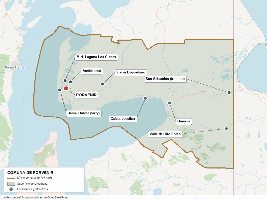
Communal boundary based on OpenStreetMap open data
§ 03 Location, Geography and Territory View
Where Porvenir is, what it is built on and why its land is abundant but not always buildable.
3.1 Location
Porvenir is at 53°18′ S and 70°22′ W, on the northwest shore of Isla Grande, on the bay that bears its name. Punta Arenas lies about 40 km in a straight line across the Strait of Magellan (about two hours on the Tabsa ferry, from the Tres Puentes terminal to Bahía Chilota, 5 km from the town) and Santiago about 2,200 km away. On the island, Cerro Sombrero (Primavera commune) is about 90 km to the northeast in a straight line, Cameron (Timaukel commune) is on the south coast of Bahía Inútil and the border with Argentina is at San Sebastián, about 115 km to the east. The commune covers the center and east of the Chilean part of the island, from the Strait to the international boundary, and includes the northern and eastern shore of Bahía Inútil.
Porvenir · 53°18′ S, 70°22′ W
3.2 Terrain and setting
The town sits on a terraced plain that rises gently from the bay, between two farellones—sea cliffs—that close the bay to the north and south and make it difficult to occupy its edge. The rest of the commune is Magellanic pampa: low hills, lagoons and ridges such as the Sierra Baquedano, on deposits of moraines and of fluvioglacial and marine sediments. According to CONAF, 27 land uses cover the commune, but three account for 73 %: open shrubland and grassland (42 %), perennial grasslands (17 %) and open shrubland (14 %). There is almost no forest, and that is why almost nothing stops the wind.
3.3 Hydrography
Main bodies of water in the commune6 rows
| Watercourse | Role in the territory |
|---|---|
| Bahía Porvenir | A shallow, sheltered bay where the town was born; its northern and southern edges are cliffs. With a high tide and strong wind it can cover the coastal avenue, as happened on July 23, 2024 |
| Porvenir River | It crosses the urban area and its mouth was channeled under the southern industrial hub; the overflow of this watercourse is the town's main natural hazard according to the zoning plan |
| Laguna Los Cisnes | A Natural Monument with seven interior islets, habitat of the black-necked swan, the flamingo and the caiquén (ashy-headed goose); it lies a few kilometers north of the town and the Los Cisnes parcel subdivision reaches its edge |
| Laguna Salada | Wetland north of the town; the zoning plan includes it among the flood areas and proposes an intercommunal park on its edge |
| Santa María, Verde, del Oro and Chico rivers | The Santa María flows into the Paso Boquerón and the Verde into Bahía Gente Grande; the Chico valley, from La Portada to the border, is a Historic Monument and a declared archaeological site |
| Porvenir Urban Wetland | 3.6 ha next to the cemetery and route Y-629, declared an urban wetland by the Ministry of the Environment (Res. Ex. 1,205, September 30, 2022; Official Gazette of November 10, 2022) |
3.4 Soils
There is no published soil study at the communal scale. What is known comes from the zoning plan's diagnosis and from CONAF's vegetation cover: the urban land is mostly on gently sloping terraces, suitable for urbanization and for a vegetable garden or greenhouse; the vocation of the rest of the commune is extensive grazing.
- Advantage: flat terraces above the bay, with streets 20 m wide in the founding core, which allow building without major earthmoving and expanding the town northward.
- Limitation: swampy ground, with liquefaction conditions, along the edges of the Porvenir River and the wetland, and steep cliffs to the north and south of the bay.
- Risk: overflow of the Porvenir River, tsunami below the 5 m contour, storm surge with wind (July 2024) and landslides on the cliffs. Eruptions of the Burney and Pali-Aike volcanoes are low risk according to SERNAGEOMIN (2011).
- Real estate implication: of the 742 urban ha, 435 are still available for development, so land is not scarce; what is scarce is urbanized land outside the risk zones.
§ 04 Climate and Seasonality View
A dry, cold climate in which the wind matters more than the rain.
Porvenir has a subpolar oceanic (Cfc) climate according to Wikipedia and a cold Mediterranean (Csc) climate according to the zoning plan; the two sources do not agree, but the available monthly data show no dry season, so Cfc better describes the curve. The mean annual temperature is 6.6 °C, with a range of just 8.9 °C between January (10.9 °C) and July (2.0 °C). The temperatures are 1996-2025 averages from the Fuentes Martínez station, at the airfield, of Chile's Meteorological Directorate (Dirección Meteorológica de Chile); that is the measurement point and it does not represent the mountains or the eastern end of the commune.
Reference climate parameters (Fuentes Martínez station, Porvenir Ad.)10 rows
| Parameter | Typical value | Comment |
|---|---|---|
| Mean annual temperature | 6.6 °C | Average of the monthly means 1996-2025 (DMC); average maximum of 11.8 °C and average minimum of 1.7 °C |
| Warmest month | January · 10.9 °C | Average maximum 16.5 °C |
| Coldest month | July · 2.0 °C | Average minimum −2.1 °C; average minimums are below zero from June to September |
| Heat record | 32.2 °C | February; 1996-2025 series from the DMC |
| Cold record | −15.7 °C | July; extremes since 1986 (Wikipedia, with DMC data) |
| Annual precipitation | 318 to 381 mm | 318 mm is the modeled communal average from ARClim (MMA 2022); 381 mm, the monthly series from MSN Weather. A third portal gives 749 mm and was discarded because it matched neither of the two |
| Days with precipitation | 128 per year | Rain of 1 mm or more: between 9 days a month (June to October) and 13 (January and December), according to MSN Weather |
| Snow | Scarce | ARClim calculates 15.6 mm of water equivalent per year and projects a 57 % drop by mid-century |
| Wind | No published average | On July 23, 2024, winds of up to 90 km/h were announced; the swell at high tide covered the coastal avenue (Meganoticias) |
| Mid-century projection | +1.3 °C, +6 % rainfall | ARClim: the communal mean goes from 5.2 to 6.5 °C and rainfall from 318 to 337 mm. The zoning plan projects +1.1 °C in summer and +1.5 °C in winter |
It is a dry, cold climate with no dry season: no month exceeds 44 mm, but it rains almost every three days and the maximum falls in March and April, not in winter. What defines how people build is not the water but the wind: with no trees to stop it, it sweeps the bay, and in July 2024 a storm lifted the sea over the coastal avenue.
In the medium term both planning documents project the same thing: higher temperatures, especially in winter, and a small increase in rainfall. For a buyer, the relevant change is not the heat but the shoreline: with the bay normally “like a cup of milk,” according to a meteorologist, the July 2024 storm showed that a sustained wind over the Strait can push the sea up to the low-lying streets of the town.
§ 05 History: Eleven Thousand Years on a Timeline View
The story of a sheltered beach that became a town to serve a gold rush and ended up serving a few estancias that occupied the whole island.
-
About 11,000 years ago
The first hunters
According to the sign at Plaza Selk'nam and the municipal guide to attractions, a first group of hunters enters the island about 11,000 years ago. The Marazzi site, on the coast of Bahía Inútil, is about 9,600 years old and is the second-oldest documented settlement on the island.
-
Centuries before 1880
The Selk'nam and Bahía Karkamke
Guanaco hunters and gatherers, organized in patrilineal clans called haruwen and with their initiation ceremony, the Hain, the Selk'nam traveled the steppe on foot. They called the bay where Porvenir stands today Karkamke, “shallow waters.”
-
1879 – 1883
Gold calls
In 1879 Lieutenant Ramón Serrano reports gold on the island. In 1883 the first prospectors land in this bay and, in the midst of the fever, a police detachment is set up. Julio Popper, based at El Páramo, in San Sebastián, works the placers, mostly on the Argentine side.
-
1883 – 1890
First livestock concessions
According to Memoria Chilena, Werhahn y Cía. receives 123,000 ha on lease in 1883. Supreme Decree 2616 of June 9, 1890 grants José Nogueira nearly a million hectares for 20 years, the start of large-scale land ownership.
-
1893 – 1894
The Sociedad Explotadora and the founding
The Sociedad Explotadora de Tierra del Fuego is formed on August 31, 1893. On June 20, 1894 Puerto Porvenir, the service town for the estancias, is officially founded; that same year the Caleta Josefina estancia starts up with 7,600 sheep.
-
1880 – 1910
The Selk'nam genocide
Estimates from before colonization range from 3,500 to 4,000 people; around 1899 the missionary Bridges counted about 783. Historians such as Alberto Harambour describe what happened as genocide, when the estancias covered the territory and the Selk'nam were persecuted or banished. There is no single death toll.
-
1890 – 1912
The Salesians
The Salesian mission on Isla Dawson receives the concession in 1890 and closes in 1912. In Porvenir, the San Francisco de Sales church is founded on April 24, 1904 through the efforts of Monsignor Fagnano, and the first school opens in 1908 with three students.
-
1914
Croatians and Chilotes
According to Memoria Chilena, around 1914 some 2,000 Croatians live in Magallanes, 10 % of the regional population, settling in Punta Arenas and Porvenir in commerce, the hotel trade and craft industry. The Chilotes arrive after the Europeans.
-
1924
The first cinema
The Teatro Cinema, owned by Antonio Radonich, formerly the Hotel Comercio, opens; it is considered the first cinema in Porvenir and in Magallanes; it closed in 1966 and reopened in May 2018. That year the first subdivision of the Sociedad Explotadora, of 200,000 ha, is also carried out.
-
1927 – 1935
Department and municipal capital
The decree with force of law of December 30, 1927 creates the Tierra del Fuego Department, with the communes of Primavera, Porvenir, Bahía Inútil and Navarino and Porvenir as capital. The Municipality begins operating on June 9, 1935; its first mayor was José del Carmen Gómez.
-
1958 – 1971
End of the Explotadora
According to the zoning plan, most of the Sociedad's leases with the State expire in 1958. The company renames itself Ganadera Tierra del Fuego in 1964 and is dissolved on August 26, 1971.
-
1975 – 1980
Province, monuments and museum
DL 1,230 of October 27, 1975 creates Tierra del Fuego Province, with Porvenir as capital. In 1976 the Onaisín and San Sebastián cemeteries are declared Historic Monuments, and on December 16, 1980 the Museo Fernando Cordero Rusque opens.
-
1984 – 1985
The ferry and the Navarino Law
Since 1984 the Transbordadora Austral Broom has crossed between Tres Puentes and Bahía Chilota. The Navarino Law of 1985 and later the Austral Law attract the marine and textile industries; at one point nine textile companies came to coexist, of which one still operates today.
-
1982 – 2015
The natural areas and Selk'nam memory
In 1982 the Laguna de los Cisnes Natural Monument is created. In 2011 the Reserva Natural Pingüino Rey (King Penguin Natural Reserve) opens and on March 15, 2015 the “Espíritus Selk'nam” sculptures are inaugurated at the approaches to the town.
-
2022 – 2023
Urban wetland and Selk'nam recognition
On November 10, 2022 the declaration of the Porvenir Urban Wetland, of 3.6 ha, is published. On October 19, 2023 Law 21,606 is published, which incorporates the Selk'nam people as the eleventh Indigenous people recognized by the State.
-
2024 – 2026
Storm surge, Nova Austral and paving
On May 13, 2024 the Porvenir Court (Juzgado de Porvenir) decrees the bankruptcy of Nova Austral, later reversed. On July 23, 2024 a storm surge covers the coastal avenue. On December 2, 2024 the Regional Council approves the new zoning plan and on March 7, 2026 the paved route Y-65 between Porvenir and Manantiales is inaugurated.
§ 06 Cultural Identity and Indigenous Peoples View
One in four inhabitants belongs to an Indigenous people: more than double the national rate, and in the territory where the Selk'nam people were nearly exterminated.
According to the 2024 Census, 1,793 people (26.3 %) declare that they belong to an Indigenous people, compared with 23.2 % in the region and 11.4 % in the country; the Social Household Registry (Registro Social de Hogares) of March 2025 gave 26.5 %. The census does not break down by people, so it is not known how many are Selk'nam. What is known is that since 2023 the law recognizes them: Law 21,606 incorporated the Selk'nam into the Indigenous Law (Ley Indígena) as the eleventh people, and the Covadonga Ona community, represented by the Corporación Selk'nam Chile and with about 12 families, is the only Selk'nam community living in the ancestral territory on the Chilean side. CONADI opened an Indigenous peoples office in Porvenir in June 2021.
The cultural strata of Porvenir5 rows
| Tier | Visible traces today |
|---|---|
| Selk'nam | Plaza Selk'nam, with ten human-scale concrete figures representing a family; “Espíritus Selk'nam” sculptures at the approaches along routes Y-629 and Y-65 (2015); sculptures at the Hain Lookout and “El Cazador Selk'nam” on the coastal avenue; Marazzi archaeological site; Río Chico valley, a Historic Monument since 1969; Hach Saye Foundation (Fundación Hach Saye) and the Covadonga Ona community |
| Croatians | Club Croata (Croatian Club) on Avenida Señoret, Croatian park and promenade of flags on the coastal avenue, immigrant monument; Croatian surnames such as Mimica and Yasic in local sources |
| Chilotes | Calle Chiloé, Chilote wooden architecture from 1890 to 1950 and, approved in June 2026, a monument and a plaza for the Bicentennial of the Chilotes on Avenida Señoret |
| British and Scots | The “English” cemetery at Onaisín, with headstones in English, a Historic Monument since 1976; the houses of the managers of the Sociedad Explotadora, such as Alexander Cameron, general manager until 1915 |
| Military and civil servants | The Regimiento Reforzado N.º 11 “Caupolicán” (Reinforced Regiment No. 11), of about 90 ha, which takes up much of the frontage of Calle Carlos Wood; the municipality, the hospital and State services |
In everyday life, the mix shows in small things: a Croatian park next to a Selk'nam plaza, an English cemetery 100 km from a Salesian church, a regiment on the main street and estancias whose surnames come from Scotland. The zoning plan describes the town's pioneer architecture as the legacy of the British estancia managers, and the tourist identity the commune is seeking rests on that plurality: gold, sheep, Croatians, Chilotes and Selk'nam memory.
§ 07 Key Demographic Data View
7.1 Population and growth
Comparative demographic indicators11 rows
| Indicator | Commune | Region | Country |
|---|---|---|---|
| Population, 2017 Census | 6,801 | 166,533 | 17,574,003 |
| Population, 2024 Census | 6,809 | 166,537 | 18,480,432 |
| Intercensal change | 0.1 % | 0.0 % | 5.2 % |
| Commune area | 9,707.4 km² | — | — |
| Population density (2024) | 0.70 inhab./km² | — | — |
| Urban population (2024) | 90.9 % (6,191) | 92.9 % | 86.7 % |
| Foreign-born population | 8.1 % (553 people) | 6.6 % | 8.7 % |
| Indigenous population (2024) | 26.3 % (1,793) | 23.2 % | 11.4 % |
| Sex ratio 2024 | 111.7 | 98.1 | 94.3 |
| Demographic Dependency Ratio (IDD) 2024 | 44.3 | 45.4 | 46.5 |
| Elderly Index (IAM) 2024 | 60.6 | 87.1 | 79.0 |
7.2 Age structure (2024 Census)
Population distribution by age group5 rows
| Age group | Population 2024 | % Commune |
|---|---|---|
| 0 – 14 years | 1,301 | 19.1 % |
| 15 – 29 years | 1,361 | 20.0 % |
| 30 – 44 years | 1,764 | 25.9 % |
| 45 – 64 years | 1,594 | 23.4 % |
| 65 years and over | 789 | 11.6 % |
Three phenomena dominate. The first is stagnation: in seven years the commune gained eight people, and over forty years it went from 7,219 inhabitants (1982) to 6,809 (2024), with a low of 5,104 in 1992. The second is age turnover: between 2017 and 2024 the 15-to-29 group lost 361 people (−21 %) and the 30-to-44 group gained 247 (+16 %); the 65-and-older group grew 20 %. The third is the sex ratio: it fell from 142.2 in 2017 to 111.7 in 2024, because men fell 10 % and women rose 15 %. Part of that change is methodological: the 2017 Census counted whoever spent the night in the commune, including military personnel and temporary workers, and the 2024 Census only habitual residents; the zoning plan attributed the male excess to the presence of men on defense duties.
In 2024, 6,191 people live in urban areas (90.9 %) and 618 in rural areas (9.1 %); in 2017 there were 6,062 and 739. The census does not show how many live on the rural parcels (parcelas de agrado) around the town. What it does show is the importance of immigration: the population born outside the country went from 3.4 % in 2017 to 8.1 % in 2024, and in 2017 more than one in three people (36 %) reported having lived in another commune five years earlier, mostly in Punta Arenas and Puerto Montt. The commune is fed more by arrivals than by births.
§ 08 Economic and Socioeconomic Data View
8.1 Poverty and social indicators (CASEN, RSH and Census)
Social indicators compared6 rows
| Indicator | Commune | Region | Country |
|---|---|---|---|
| Income poverty, Casen 2024 (2024 methodology) | 7.1 % | 9.9 % | 17.3 % |
| Multidimensional poverty, Casen 2024 | 9.9 % | 6.1 % | 17.7 % |
| People in households lacking basic services (RSH June 2026) | 11.0 % | 6.8 % | 12.9 % |
| Overcrowded households (RSH June 2026) | 4.3 % | 5.0 % | 7.8 % |
| Average years of schooling (2024 Census) | 9.9 | 10.7 | 10.4 |
| People with disabilities, aged 5 or older (2024 Census) | 8.7 % | 9.2 % | 11.1 % |
The 2024 Casen survey introduced a new methodology that raises the poverty line, so its figures are not comparable with those of 2022. In it, Porvenir has less income poverty than the region (7.1 % versus 9.9 %) but more multidimensional poverty (9.9 % versus 6.1 %): relatively good incomes, tied to industrial and public employment, with shortfalls in housing, services and schooling. That reading matches the Social Household Registry, which records 11 % of people in households without full access to basic services (9.9 % in March 2025), almost double the region, and the average schooling of 9.9 years, 0.8 less than the regional figure. The earlier series, with a different method, already showed the same trend: multidimensional poverty rose from 8.3 % in 2017 to 12.4 % in 2022 while the region's was falling.
8.2 Economic activity (SII) and municipal finances (SINIM)
Business structure and municipal finances10 rows
| Economic indicator (SII / SINIM) | Value |
|---|---|
| Active businesses, 2024 (SII) | 853 (838 in 2022); 12.5 per 100 inhabitants, versus 10 in the region and 8 in the country |
| By size according to sales, 2024 | 552 micro, 145 small, 9 medium, 13 large, 134 with no sales |
| Salaried workers | 3,528 in 2024; 3,734 in 2023; 3,978 in 2022 |
| Workers at the 13 large companies, 2024 | 2,156 (61 % of the total) |
| Agriculture, livestock, forestry and fishing, 2024 | 141 companies · 359 workers (1,205 in 2023; 602 in 2022) |
| Manufacturing, 2024 | 83 companies · 1,836 workers (1,079 in 2023; 1,954 in 2022) |
| Wholesale and retail trade, 2024 | 228 companies (27 %) · 473 workers (13 %) |
| Accommodation and food service, 2024 | 83 companies · 123 workers |
| Municipal revenue 2025 (SINIM) | $8,108 million (4,980 in 2024); Municipal Common Fund 36.6 %, transfers 35.0 % ($2,837 million) and permanent own revenue 24.3 % ($1,972 million) |
| Municipal and mining licenses | Municipal licenses $811 million in 2025 (41 % of permanent own revenue); mining licenses $15.6 million, after $52.6 million in 2024 |
The business structure has two sides. By number, commerce dominates: more than one in four companies, with 13 % of workers. By employment, agriculture-fishing and manufacturing dominate, together totaling 2,195 jobs in 2024 (62 % of the total) and concentrated in a few large companies. The SII assigns each worker to the sector of their company, so the two sectors taken separately jump from one year to the next (agriculture-fishing went from 602 to 1,205 and then to 359 workers); the sum is more reliable, and it is slow and declining: 2,556 in 2022, 2,284 in 2023 and 2,195 in 2024. At the municipal level, the budget grew 63 % in 2025, mainly because of transfers for projects (from $306 to $2,837 million); what the municipality generates by itself, the permanent own revenue, is around $2,000 million, and its largest item is the commercial and industrial license.
§ 09 The Economic Engine: Sheep, Salmon and Energy Projects View
Porvenir lives off three very different activities: sheep, which has been going for over a century; salmon, which provides industrial employment but depends on a judicial process; and energy and public works, which are a promise in progress.
9.1 Sheep farming
Livestock is the commune's most stable activity and the one that gave rise to the town. In 2007 Porvenir had 649,643 sheep, 29 % of those in Magallanes (2007 Agricultural Census). I was unable to obtain the 2021 communal figure, but I did get the regional one: according to ODEPA, Magallanes has 1,417,421 sheep and is the country's leading sheep region with 56 % of the national total. The trend is downward: 35.6 % fewer than in 2007.
Sheep stock in Magallanes (farms with 60 or more head, ODEPA)3 rows
| Year | Sheep in Magallanes | Interpretation |
|---|---|---|
| 2007 | 2,201,911 | Porvenir had 649,643 sheep, 29 % of the region |
| 2017 | 1,571,056 | −28.7 % in ten years |
| 2021 | 1,417,421 | −9.8 % since 2017; −35.6 % since 2007 |
The region concentrates almost all of the country's sheep slaughter (93 % of carcass meat in 2025, with 7,287 tonnes) and exported US$31.1 million of sheep meat and US$12.5 million of wool that year, although the president of Asogama warned in 2025 that the price of wool is falling because of low world demand. But Porvenir no longer has anywhere to slaughter: the SAG shut down the Koba slaughterhouse in September 2021, on the road to the Cordón Baquedano, and it remains closed at least until October 2025; local butchers report clandestine slaughter and I did not find a verified export plant in the commune. The nearest meatpacking plant that slaughters sheep that I identified is in Punta Arenas.
Two pressures hit the estancias. The first is drought: on January 13, 2023 an agricultural emergency due to water deficit was decreed in Magallanes, which included Porvenir. The second is predation: a diagnostic study by the Wildlife Conservation Society (2019) found that between 2012 and 2017 59 % of the reports to the SAG for predation came from Tierra del Fuego, with 1,723 animals killed (76 % of the regional loss) and 82 % attributed to feral dogs. The 43 estancias surveyed, 27 of them in Porvenir, averaged 4,098 ha.
9.2 Salmon farming: Nova Austral
Nova Austral is the commune's largest industrial employer and also its main source of uncertainty. It has its headquarters and processing plant in Porvenir, on Avenida Alberto Fuentes; the recirculation fish hatchery is about 42 km from the town, the administrative office is in Punta Arenas and its 28 sea concessions are in other areas of Magallanes. It processes fresh, frozen and filleted salmon under the Sixty South brand. Since 2023 it has been going through a judicial reorganization process that has taken place in the Civil and Criminal Guarantee Court of Porvenir (Juzgado de Letras y Garantía de Porvenir) itself.
Nova Austral: judicial timeline and key figures7 rows
| Date | Event | Detail |
|---|---|---|
| January 2024 | Reorganization agreement | Approved by 92 % of creditors, with liabilities of US$559 million; ownership passes to the creditors |
| May 13, 2024 | Bankruptcy decreed | The Porvenir Court decrees liquidation; the Punta Arenas Court of Appeals reverses it in August |
| September 26, 2025 | The Supreme Court annuls the agreement | It upholds Nutreco's complaint of unequal treatment among creditors and gives ten days for a new proposal |
| November 21, 2025 | The new plan is approved | The court approves it with 93 % of creditors; the only vote against was from Salmonífera Dalcahue. Owner: Larta Investment Group |
| July 2026 | Strike announced | On July 20, the plant's main union rejects the offer (87 % against) and announces a legal strike for the 27th; there is no later press coverage and I could not confirm how it ended. Other unions had already closed contracts |
| Employment | Between 680 and 760 direct | 683 workers according to the company (November 2025) and 764 employees in the region in 2024; about 900 were cited in January 2024 and “more than 3,000 direct and indirect” in November 2025 |
| Production | Falling | Harvest of 8.7 thousand tonnes in the 12 months to June 2024, 46 % less than a year earlier; revenue of US$85.9 million in 2024, 25 % less than in 2023 |
To understand the company's weight you have to look at the SII data carefully: manufacturing went from 1,954 workers in 2022 to 1,079 in 2023 and back to 1,836 in 2024. I did not find a documented explanation. The SII assigns workers to the headquarters' address and not to where they work, and the 2023 layoffs (about 35 direct and about 100 letters to contractor workers) are not enough to explain a drop of 875 people; the most likely cause is a reclassification between the agriculture-fishing and manufacturing sectors, because the sum of the two sectors moved slowly (2,556, 2,284 and 2,195). What is certain is that the company employs between 680 and 760 people and there is no other activity in the commune that could absorb them.
9.3 Other economic pillars
- Green hydrogen (Gente Grande, TEG Chile): a project of about 38,000 ha between Primavera and Porvenir, with about 460 wind turbines, a target of 1.3 to 1.5 million tonnes of ammonia per year and an announced investment of between US$6,000 and 7,000 million; the company estimated about 600 direct jobs in operation and up to 6,000 in construction. The filing of its environmental impact study was postponed at least four times since 2024 and I found no record of filing with the SEIA (Environmental Impact Assessment System) or of an environmental qualification resolution as of October 2026. A September 2026 report counted a single green hydrogen project with an environmental permit in Chile, in another commune, and zero final investment decisions.
- Natural gas: ENAP's Sara–Clarencia gas pipeline, of about 56 km and US$15.5 million, has had environmental approval since January 2025 and is intended to supply Porvenir. Its operation was announced for 2027, but the July 2026 inspection tender contemplates a start of works in November and 16 months of execution, so operation would move to 2028.
- Public works under way: route Y-65 between Porvenir and Manantiales was inaugurated paved on March 7, 2026 (more than $110,000 million); the Y-71 toward Onaisín is still under construction with completion planned for 2028-2029; the Bahía Chilota maritime terminal was inaugurated expanded in September 2026 (more than $5,000 million, with a fifth boarding lane); and the new hospital cost $16,000 million (2018). The airfield modernization was announced at $20,000 million, but on August 25, 2026 the runway improvement project was withdrawn from the Regional Council's agenda and no works have begun.
- Gold mining: ENAMI met in Porvenir on September 22, 2026 with 16 small-scale miners from the Cordón Baquedano and presented a gold-buying scheme (poder de compra de oro) with a laboratory at the Universidad de Magallanes, still with no start date.
- Textile: nine textile companies came to coexist; according to the zoning plan only Textil Mejillones was still operating, whose current status I could not verify.
- State: the Destacamento Motorizado N.º 11 “Caupolicán” (Motorized Detachment No. 11) and Gendarmería's Pretrial Detention Center (Centro de Detención Preventiva) are fixed public employers, with no verified staffing.
- Tax benefits: the Austral Law, which covers all of Magallanes, gives a credit against first-category income tax of 10 %, 15 % or 32 % depending on the amount invested, for projects through December 31, 2035, and a 17 % subsidy on wages; they benefit companies with full accounting and not the individual buyer. The Special Plan for Extreme Zones (Plan Especial de Zonas Extremas) 2025-2035 is public investment of $2.4 trillion; for the island it includes route Y-71, drinking water at Bahía Chilota and the Tierra del Fuego waste center.
§ 10 Real Estate Market View
10.1 Available properties and property types
The market is small and has almost no published liquidity: on October 7, 2026 the portal Yapo showed 11 sale listings in Porvenir. Rural parcels of between half a hectare and one hectare predominate (six of the eleven listings, three with a house and three with no buildings), 3 to 20 minutes from the town: on route Y-65, in the Santa María sector, on the road to the Cordón Baquedano and in the “Hacienda Santa Palmira,” 4 km away. The rest are a central urban lot, a house in Lomas de Baquedano, a regularized lot with a house and five cabins, an eleven-room hotel and a 50 m² building in a subdivision. Almost all list the price in pesos, not in UF.
10.2 Average price by property type (indicative, October 2026)
Reference price ranges by property type (listings of October 7, 2026; UF ≈ $41,100)6 rows
| Property type | Indicative price range | Notes |
|---|---|---|
| Unbuilt rural parcel, 5,000 m² to 1.1 ha | $15.5 to $20 million (UF 377 to 487) | Between UF 440 and 970 per hectare. The one on route Y-65 (5,000 m², $15.5 million) mentions a nearby residential gas network and fiber optics; commission of 2 % plus VAT (IVA) |
| 5,000 m² parcel with a house | $50 to $170 million (UF 1,217 to 4,136) | From a 110 m² house built in 2021, with tank water and firewood ($50 million), to a three-bedroom one with a quincho (barbecue pavilion) for 60 people ($170 million) |
| Central urban lot | $75 million (UF 1,825) | 600 m² on Calle Croacia, near the plaza: about UF 3 per m². It says it has feasibility for all services |
| Urban lot with house and cabins | $190 million (UF 4,623) | 1,250 m² regularized within the urban radius, with a three-bedroom house and five cabins |
| House in a housing-development neighborhood | $80 million (UF 1,946) | 55 m² in Lomas de Baquedano, with an interior cabin 80 % finished; accepts mortgage financing |
| Hotel | UF 12,065 | Eleven rooms and 501 m² in the very center, with central heating and licenses |
This is a snapshot of asking prices from eleven listings, not of transactions: there is no public series of sales and it is not enough to calculate an average. Two facts do show. The first is that rural land is worth little and construction explains almost the entire price: half a hectare costs between $15 and $20 million and the same area with a house rises to $50 to $170 million. The second is that central urban land, at UF 3 per square meter, costs between 30 and 40 times more per square meter than the rural land on route Y-65 (which works out to less than UF 0.1 per m²). In addition, according to the zoning plan's diagnosis, local real estate activity is small and housing growth depends on SERVIU projects and on self-build on parcels.
10.3 What determines the price in Porvenir
Valuation factors the market highlights, not quantified (sample of eleven listings)5 rows
| Factor | Evidence in the market | How to check it here |
|---|---|---|
| Services that reach the property (gas network, fiber optics, mains water, utility connection) | It is what the parcel listings highlight most; without a water network, the usual solution is to fill tanks and have a septic tank and solar panels | Feasibility of water with Aguas Magallanes, of gas with Gasco Magallanes and of electricity with Edelmag; request it in writing before paying |
| Built house | Construction explains most of the price: from $15 to $20 million without a house to $50 to $170 million with a house | Building permit and final reception (recepción final) of the house, at the Municipal Works Department |
| Distance to town and road | The listings specify the minutes to the center (3 to 20) and say “3 km away” or “4 km away.” Route Y-65 was paved in concrete in March 2026, which favors the parcels fronting it, but not necessarily the interior roads leading to each one | Travel the access road in winter and confirm whether the road is public and who maintains it |
| Zoning plan zone (urban, regulated rural area or outside both) | Defines what can be built and whether there is a network; the 2002 plan and the new one do not coincide | Certificate of Prior Information from the Municipal Works Department; ask which plan governs that day |
| Flood, tsunami or slope risk | It does not appear in the listings, but it restricts building next to the Porvenir River, Laguna Salada and the cliffs | Risk-area map of the zoning plan, at the Municipal Works Department |
§ 11 Territorial Planning in Porvenir View
What Porvenir's planning instrument allows and prohibits, and why two plans, both under discussion, coexist today.
The zoning plan in force is the one from 2002, which replaced one from 1990 and was made to take advantage of the incentives of the Austral Law; the SINIM records zero sectional plans approved since then. It defines three macro-areas —consolidated, urban extension and special— over an urban limit of 742 hectares. In the 2021 diagnosis, 33 % of that land was consolidated (246 ha) and 67 % was not (496 ha), so 435 ha, 59 %, are available for development, and 61 ha are ruled out because of risk. Only 25 % of the 90 ha military compound is inside the urban limit.
The Municipality began the update in 2020-2021. The January 2023 preliminary draft expands the urban limit by 167 ha, to 909 ha (the target image had proposed 260 ha more), zones the military compound as a facility (equipamiento), proposes intercommunal parks on the edge of Laguna Los Cisnes, Laguna Salada and the Porvenir River, and reduces the buildings for historic conservation from 34 to 22. The Magallanes Regional Council approved it unanimously on December 2, 2024, and the mayor said its submission to the Comptroller's Office (Contraloría) was next. As of October 2026 I found no record of the Comptroller's review (toma de razón) or of its publication in the Official Gazette, so the only rule with confirmed legal force remains the 2002 one.
Main zones of the 2023 preliminary draft (27 zones in total) and what they allow8 rows
| Zone | Permitted use | Key restriction |
|---|---|---|
| CC · Civic Center | Commerce, services, culture, education, health and housing of the founding core | Up to 3 floors (10.5 m) |
| HM · Mixed Residential | Housing, commerce, services, education, health and sports | Minimum lot 300 m²; up to 150 inhab/ha; lot coverage 0.7; up to 3 floors |
| H3 · Residential 3 | Housing, neighborhood commerce and education | Minimum lot 300 m²; up to 150 inhab/ha; coverage 0.7 |
| H2 · Residential 2 | Low-density housing and lodging | Minimum lot 1,200 m²; detached buildings; lot coverage 0.4 |
| H5 · Residential 5 | Housing only | Minimum lot 2,500 m²; 20 inhab/ha; up to 2 floors (7 m) |
| T1, T2, T3 · Tourist residential | Housing, hotels, hostels and commerce; T1 in the founding core, T2 on the coastal cliff and T3 at Bahía Chilota and the wetland park | Minimum lot 350 m² (T1), 700 m² with 60 inhab/ha (T2) and 500 m² (T3) |
| AP1, AP2, AP3 · Productive activity | Workshops, warehouses, industry, commerce and infrastructure; AP3 is port | In AP2, minimum lot of 1,000 m² for facilities and 2,500 m² for productive activity |
| Regulated Rural Area (transitional) | Housing only and the facilities the law always allows outside the urban limit | Any use not listed is prohibited, including industry and aggregate extraction; it surrounds the urban perimeter, with the Los Cisnes and Selknam parcel subdivisions |
The risk areas declared in the preliminary draft are four: flooding from overflow of the Porvenir River, Laguna Salada and terrain depressions; tsunami flooding below the 5 m contour; slopes above 15° and aggregate pits; and land at risk from human intervention. On the coast an 80 m protection strip from the beach line is added, where lot coverage cannot exceed 0.3, and a 20 m non-buildable strip from the highest-tide line: restrictions that weigh on any project on the coastal avenue or at Bahía Chilota.
The protections that apply in Porvenir and not just anywhere are the Laguna Los Cisnes Natural Monument (seven interior islets, managed by CONAF), the 3.6 ha Porvenir Urban Wetland, the 22 proposed buildings for historic conservation (34 in the 2002 plan; among them the former Red Cross building and the first cinema in Magallanes), the Historic Monuments of the Onaisín cemetery, the San Sebastián one and the Río Chico valley, and the 10 km strip from the border, where State-owned (fiscal) lands can only be acquired by Chileans (DL 1,939, art. 6).
§ 12 Neighbourhoods and Areas View
Porvenir is organized around a founding grid of 10 by 10 blocks with streets 20 m wide, surrounded by a perimeter road formed by Esmeralda, John Williams, Señoret, Alberto Fuentes and Carlos Wood avenues. From that road the roads lead to the airfield, Bahía Chilota, Cerro Sombrero, Onaisín and the Cordón Baquedano. To the east is a large military compound and, to the northwest and south, two industrial hubs that held back growth toward those sides and pushed the new neighborhoods northward. Plaza Arturo Merino Benítez concentrates the services; the restaurants and cafés are on Calle Croacia and Avenida Señoret.
Sectors of the town and their profile6 rows
| Sector | Features | Market profile |
|---|---|---|
| Founding core | Grid of 10 × 10 blocks, with lots of between 400 and 1,200 m² and densities of up to 75 inhab/ha; plaza, commerce, services and the pioneer houses | Central urban lot at about UF 3 per m² (Calle Croacia); the most stable part of the market |
| North and northeast (John Williams, Lomas de Baquedano) | Social housing and integration developments, with lots of between 100 and 250 m² and the highest densities in the town (up to 250 inhab/ha) | Houses of about 55 m² at around $80 million; demand from young families, heavily subsidized |
| Bahía Chilota | Ferry pier, 5 km from the town, with a small settlement of port and craft activities | Small; the new plan expands it for tourism purposes |
| Industrial hubs (northwest and south) | Calle John Williams and Avenida Esmeralda east; to the south, the Nova Austral plant and a hub over the mouth of the Porvenir River. Lots of 1.5 to 2 ha | Non-residential; the industrial location generates bad odors in nearby homes |
| Cliffs and bay edge | Steep slopes to the north and south of the bay; the plan in force allocated them to residential and tourist use and they have hardly been occupied | No market yet; limited by slope, tsunami and the coastal strip |
| Parcel subdivisions outside the urban limit | Los Cisnes, Selknam, Santa María, route Y-65 and the road to Baquedano: parcels of 5,000 m² to 1 ha, with houses and small greenhouses | Between UF 440 and 970 per hectare without a house; no sanitation network; they are the proposed regulated rural area |
§ 13 Basic Services, Utilities and Digital Connectivity View
Practical information that rarely appears in descriptions of a commune but that nonetheless determines whether any property is viable.
Service providers and coverage8 rows
| Service | Provider / operator | Practical notes |
|---|---|---|
| Electricity | Edelmag | Porvenir has its own power plant, with natural gas engines and diesel backup (CNE-Systep study, 2014; I could not verify the current composition). On parcels without a grid connection, the sale listings offer solar panels |
| Urban drinking water | Aguas Magallanes | It is supplied from two surface intakes —a reservoir in an unnamed lagoon, of 11.6 L/s, and the Casas de Lata brook (chorrillo), of 13 to 30 L/s depending on the season—, not from groundwater (2021 fact sheet) |
| Rural drinking water | Tank or private well | I did not find a list of rural drinking-water committees near the town. The parcel listings speak of “water tank filling”; the zoning plan's diagnosis mentions public investment in rural drinking water in the agricultural subdivisions |
| Sewerage | Aguas Magallanes (town) | On the parcels, septic tank. I could not verify urban coverage |
| Gas | Gasco Magallanes | It holds a natural gas concession in Porvenir; a listing on route Y-65 says it is near the network. ENAP's Sara–Clarencia gas pipeline (56 km, US$15.5 million) was announced for 2027, with works planned to start in November 2026 |
| Heating | Firewood and gas | Firewood predominates on the parcels; piped gas, in the town |
| Internet and phone | Fibra Óptica Austral, Movistar | In May 2022 Subtel (the Undersecretariat of Telecommunications) announced the arrival of fiber and Movistar 5G in the town; a Y-65 listing declares fiber service. I could not verify coverage on parcels or from other operators |
| Waste collection | Municipality | The provincial sanitary landfill for Porvenir, Primavera and Timaukel, of about 150 ha, 5 km from the town along the Y-71, remains “in project” as of June 19, 2026: the 2026 deadline announced in 2023 was not met. In the meantime a municipal dump is used |
§ 14 Health View
An accredited community hospital that handles the basics on the island and refers complex cases by plane.
The commune's health care depends on the Magallanes Health Service (Servicio de Salud Magallanes), which has run the Porvenir hospital as a community hospital since 2008. It is a low-complexity, inpatient facility, according to the Superintendency of Health's registry. There are no family health centers or clinics in the commune according to the BCN: primary care operates inside the hospital, through an attached outpatient clinic (consultorio de atención abierta), with an assigned population of about 6,000 people (5,455 from the urban area of Porvenir, 700 from Primavera and 150 from Timaukel). At the end of 2025, 4,735 people were enrolled and validated in primary care.
The commune's health network4 rows
| Facility | Type | Detail |
|---|---|---|
| Dr. Marco Chamorro Iglesias Community Hospital (Carlos Wood 480) | Low-complexity inpatient care | 15 beds; emergency room with a resident physician, basic hospitalization, basic laboratory, imaging (ultrasound), operating room and dental emergencies. It was the country's first community hospital accredited for quality (2015), reaccredited in 2020 with validity until May 12, 2027 |
| Outpatient Care Clinic | Primary care | Attached to the hospital; includes check-ups, care for illnesses and monthly rural rounds with a physician, dentist and midwife |
| Private health center and dental clinic | Private | The BCN records one of each type in 2026; I could not identify their names |
| Timaukel Rural Health Post and medical stations of Cerro Sombrero and Pampa Guanaco | Rural health posts | They serve the neighboring communes of the island, supported by rounds from the Porvenir hospital |
The current building was inaugurated with the move on January 4, 2018 and the first surgeries in the operating room, on January 29. It cost $16,000 million and has 5,420 m² on two floors. The Health Service schedules annual rounds of specialists; the most requested are ophthalmology, otolaryngology and psychiatry. Vital indicators are good for a young commune: a general mortality rate of 5.2 per thousand (6.6 in the region) and a birth rate of 8.45 per thousand (7.91 in the region), according to the BCN for 2023.
§ 15 Education View
15.1 School education
According to the BCN (2026 edition, with MINEDUC data), in 2025 the commune has 4 schools —two of the Servicio Local de Educación Pública Magallanes (Magallanes Local Public Education Service), which took over the municipal schools in 2024, and two subsidized private ones— and an enrollment of 1,165 students, 86 fewer than in 2023. The Local Service accounts for 846 and the subsidized schools 319. By level, there are 93 children in early childhood education, 705 in primary, 298 in scientific-humanistic secondary and 34 in technical-professional secondary. A third-party directory lists five schools, one more than MINEDUC counts, and I could not identify which one stopped appearing.
Notable schools4 rows
| Facility | Type | Distinction |
|---|---|---|
| Liceo Polivalente Hernando de Magallanes | Servicio Local Magallanes (inferred) | Secondary education; it is the town's high school |
| Escuela Libertador Bernardo O'Higgins Riquelme | Servicio Local Magallanes (inferred) | Pre-K to 8th grade; the mayor described it as overcrowded with about 500 students, and a new school has been in the works since 2024 |
| Colegio María Auxiliadora | Subsidized private | Pre-K to 8th grade |
| Escuela Especial Club de Leones Cruz del Sur | Subsidized | Special education; the BCN records 21 special education students in 2025 |
SIMCE 2025 results (preliminary as of July 15, 2026)7 rows
| SIMCE test | Commune | Region | Country |
|---|---|---|---|
| 4° básico (Grade 4), reading | 262 | 275 | 276 |
| 4° básico (Grade 4), mathematics | 244 | 259 | 262 |
| 8.º básico (Grade 8), reading | 218 | 236 | 238 |
| 8.º básico (Grade 8), mathematics | 242 | 255 | 258 |
| 8.º básico (Grade 8), history | 231 | 247 | 250 |
| 2.º medio (Grade 10), reading | 249 | 245 | 250 |
| 2° medio (Grade 10), mathematics | 230 | 254 | 263 |
The preliminary 2025 results are low: in six of the seven tests the commune is below the region, with differences of between 13 and 24 points; the largest is 2.º medio (Grade 10) mathematics (230 versus 254 in the region and 263 in the country). The exception is 2.º medio (Grade 10) reading (249, above the region and one point from the country). In 2024 the commune matched the country in 4.º básico (Grade 4) reading (278) and exceeded it in mathematics (272 versus 264), so 2025 is a sharp drop, although preliminary and with small cohorts. The average schooling in the 2024 Census is 9.9 years, versus 10.7 in the region.
15.2 Higher education
Porvenir had a University Center of the Universidad de Magallanes, which in 2017 offered General Accountant, University Technician in Risk Prevention, Higher-Level Technician in Nursing and in Early Childhood Education Assistant. I could not verify the 2026-2027 offering: the university's admissions portal lists only the Puerto Natales and Puerto Williams campuses. In practice, whoever wants to pursue a degree goes to Punta Arenas, which helps explain why the 15-to-29 age group lost 21 % of its population between censuses.
Higher education institutions present in the commune1 row
| Institution | Type | Remarks |
|---|---|---|
| Universidad de Magallanes (UMAG) | State | Porvenir University Center with four technical degree programs in 2017; current offering unverified |
§ 16 Steppe, Wetlands and Bahía Inútil: Natural Environment View
Porvenir is the gateway to the Fuegian steppe and, within its own commune, has a very little-altered natural environment: a lagoon with birdlife six kilometers from the town, wetlands, the northern and eastern shore of Bahía Inútil and the only place in Chile where a king penguin colony can be seen. Almost everything is more than a hundred kilometers away by road, which explains why tourism does not stay in the town.
Natural and historic attractions by distance from Porvenir8 rows
| Attraction | Approx. distance | Activities |
|---|---|---|
| Laguna de los Cisnes Natural Monument | 6 km north, via the Y-629 | Birdwatching —black-necked swan, coscoroba swan, Chilean flamingo and caiquén (ashy-headed goose)— and the Stromatolite Park (Parque de los Estromatolitos). The monument protects the seven interior islets, about 25 ha, according to CONAF |
| Bahía Chilota and lighthouse | 8 km, via the Y-625 | Coastal walk and ferry boarding; the terminal is about 5 km from the town |
| Laguna Santa María and Laguna Verde | 11 and 15 km | Steppe bodies of water; Laguna Verde is a summer resort |
| Cordón Baquedano and Circuito del Oro (Gold Circuit) | Circuit of about 115 km, via the Y-635 | Gold history and sod-hut settlements (champas de pasto); small-scale miners are active |
| Caleta Josefina and Onaisín | 102 km, via the Y-71 | Estancia Caleta Josefina (1894) and the “English” cemetery at Onaisín, a Historic Monument since 1976 |
| Marazzi archaeological site | 112 km, via the Y-71 | 600 m from Bahía Inútil; about 9,600 years old |
| Reserva Natural Pingüino Rey (King Penguin Natural Reserve) | 112 to 115 km; the Y-71 to Onaisín and 14.5 km on the Y-85 | Guided visit to a king penguin colony, with advance booking; season from October to May |
| San Sebastián and Río Chico valley | About 141 km | San Sebastián cemetery, a Historic Monument since 1976, and border crossing; the Río Chico valley has been a Historic Monument since 1969 |
Porvenir, Bahía Inútil, the King Penguin reserve and the border with Argentina
Protected areas are few. The Laguna de los Cisnes Natural Monument and the Porvenir Urban Wetland (3.6 ha) are the ones with official protection. The Reserva Natural Pingüino Rey is private: the Fernández Durán family created it in 2011, it has 36 ha of public use and 60 of mitigation, and it generates its own energy with solar panels and wind turbines. The Wildlife Conservation Society's Karukinka Park and the towns of Cameron and Lago Blanco are in the neighboring commune of Timaukel. The commune's rural territory is, in essence, a system of estancias, according to the zoning plan: land that seems free usually has an owner.
§ 17 Connectivity and Transportation View
17.1 Road network
Porvenir is the junction of the routes of the Chilean island: from the town leave route Y-65 toward Primera Angostura, route Y-71 toward Onaisín and the border, route Y-629 to the airfield and the lagoon, and route Y-625 to Bahía Chilota. Route Y-65 was paved in concrete in 2026: 120 km between Porvenir and Manantiales, inaugurated on March 7 with an investment of more than $110,000 million. Route Y-71, by contrast, is still under construction. Anyone planning to go to Onaisín, to Pingüino Rey or to the border should check the route's status the same day, because the MOP publishes a periodic report and there are detours.
Routes and distances10 rows
| Route / destination | Distance and details |
|---|---|
| Airfield and Laguna Los Cisnes | 5 to 6 km via the Y-629 |
| Y-65 Porvenir–Manantiales | 120 km paved in concrete, inaugurated on March 7, 2026; it is the access to Primera Angostura |
| Y-71 Porvenir–Onaisín | 95 to 100 km. According to the MOP report of August 17, 2026: pavement at km 0 to 11, detours under the contract between km 11 and 59 and new pavement with works between km 59 and 95. 60 km are being paved; 20 were opened in January 2026 and total completion is expected between 2028 and 2029 |
| 257-CH toward San Sebastián | Onaisín–San Sebastián stretch (km 135.7 to 180.9) under improvement works; the MOP reports it as “wet pavement in sections” |
| Y-85 Onaisín–Cameron | Gravel, being improved. Cameron is about 147 km from Porvenir |
| Cerro Sombrero | 120 to 125 km |
| Reserva Pingüino Rey (King Penguin Reserve) | 112 to 115 km |
| San Sebastián border crossing | About 140 to 145 km; calculated figure, not official |
| Río Grande and Ushuaia (Argentina) | About 220 and 440 km; estimates, not official |
| Punta Arenas | Across the Strait, about 2 hours by ferry plus 5 km between Bahía Chilota and Porvenir; overland, about 330 to 340 km via Primera Angostura plus the ferry crossing |
Porvenir facing Punta Arenas, on the axis of the Strait of Magellan
17.2 Ferries and airfield
Porvenir is linked to the mainland by three routes: the Tabsa ferry from Punta Arenas, the Primera Angostura ferry and the plane. Five years ago the zoning plan criticized that the crossing to Punta Arenas had only one departure a day; the October and November 2026 schedule offers two or three departures a day, which Tabsa publishes month by month and which depend on sea conditions. In September 2026 the expansion of the Bahía Chilota terminal was inaugurated, with a fifth boarding lane, for more than $5,000 million.
Fact sheet on sea and air access (fares since April 9, 2026)5 rows
| Fact | Detail |
|---|---|
| Tres Puentes–Bahía Chilota ferry (Tabsa) | Vessel Pathagon; about 2 hours (sources give between 1 h 50 and 2 h 20). Passenger $12,000, senior citizen $10,000, children under 6 free. Car or pickup truck up to 6 m, with driver, $78,500; motorcycle $39,500; van, motorhome or minibus $158,500. Office in Porvenir: Manuel Señoret 831, telephone (61) 272 8100 |
| October and November 2026 schedule | Saturday, Sunday and Monday: 09:30 from Punta Arenas and 19:00 from Porvenir. Tuesday and Thursday: 09:00 and 18:00 from Punta Arenas and 15:00 from Porvenir. Wednesday and Friday: 17:30 from Punta Arenas and 08:00 and 20:30 from Porvenir. There are occasional exceptions; check at tabsa.cl |
| Primera Angostura ferry (Punta Delgada–Bahía Azul) | 5 km crossing, about 20 to 25 minutes. Foot passengers, free; car or pickup truck $26,000; motorcycle $13,000; van, minibus or truck up to 6 t $52,000 |
| Flights (Aerovías DAP) | Monday to Friday: Punta Arenas–Porvenir at 08:15 and 16:30, and Porvenir–Punta Arenas at 08:35 and 17:00. The flight takes about 12 minutes; luggage of 10 kg in the hold and 5 in the cabin. DAP does not publish the fare |
| Capitán Fuentes Martínez Airfield (SCFM) | 5 or 6 km from the town via the Y-629; asphalt runway of 2,500 × 30 m according to third-party sources. The MOP announced more than $20,000 million in 2024; on August 25, 2026 the runway improvement project was withdrawn from the Regional Council's agenda and no works have begun |
17.3 Road and urban transportation
- Rural buses: the Municipality of Primavera publishes a Porvenir–Cerro Sombrero service (Monday to Friday at 16:00 from Porvenir; return, Monday 07:00 and Tuesday to Friday 08:30); its page has no date. The buses to Cameron and Pampa Guanaco have undated schedules: confirm them with the Municipality.
- To Argentina: I did not find a regular bus service from Porvenir to Río Grande or Ushuaia; the company Tecni Austral operates Punta Arenas–Río Grande–Ushuaia and is not listed as stopping in Porvenir. The San Sebastián crossing changes its hours by season (between December 2, 2025 and February 28, 2026 entry into Chile was from 06:00 to 22:00 and exit from 06:00 to 21:40); confirm before traveling.
- Urban transport: the town is compact, with a grid of 10 × 10 blocks that allows getting around on foot or by bicycle. I could not verify the existence of shared taxis (taxis colectivos) or a bus terminal.
- Railway: there is none.
§ 18 Tourism: Development, Attractions and Things to Do View
18.1 Tourism development
Tourism in Porvenir is still incipient. The zoning plan acknowledges that the commune holds a “complementary and secondary” place compared with Punta Arenas, Natales and Torres del Paine, and that its range of services is scarce. The PLADETUR (tourism development plan) of Tierra del Fuego Province, drawn up between 2018 and 2019 by the three municipalities, noted that a Tourist Interest Zone declaration and an island brand were lacking; in 2026 Magallanes still has only two ZOIT, Natales–Torres del Paine and Cabo de Hornos. The visitor count of the tourism office and museum went from 773 visits in 1993 to 15,328 in 2018. In 2026 the three communes of the island presented the “Ruta del Fuego,” a binational circuit, at the FIT fair.
18.2 Tourist attractions in the commune
- Reserva Natural Pingüino Rey: admission of $20,000 for adults, $15,000 for young people aged 11 to 17 and Chilean senior citizens, $7,000 for residents of Chilean Tierra del Fuego and free up to age 10; it is paid on site and online booking is mandatory. It opens from October to May, with guided visits every hour. There were between 140 and 160 birds and 45 to 55 pairs in 2022.
- Laguna de los Cisnes Natural Monument: 6 km from the town; black-necked swans, flamingos and stromatolites, with walkways in the Parque de los Estromatolitos (Stromatolite Park).
- Coastal avenue, Muro Histórico (Historic Wall) and Hain Lookout: the promenade in front of the bay has a historic wall from 2010, Selk'nam sculptures at the Hain Lookout and flamingos in winter.
- Plaza Selk'nam and “Espíritus Selk'nam” sculptures: ten human-scale figures in the plaza and the sculptures at the approaches, inaugurated in 2015.
- Circuito del Oro (Gold Circuit) and Cordón Baquedano: about 115 km of route with sod-hut settlements (champas de pasto) and gold placers.
- Río Chico valley, Marazzi and the Onaisín and San Sebastián cemeteries: Historic Monuments and archaeological sites of the island.
18.3 Museums and culture
- Museo Fernando Cordero Rusque (Jorge Schythe 71): opened on December 16, 1980 and has four areas: flora and fauna, archaeology and ethnography, colonization and historical-social development. Admission $3,000, which includes the church's Historic Complex; free for residents of the commune, under-18s and Chilean seniors aged 60 and over. The Registro de Museos de Chile (Chile's museum registry) publishes a schedule (Monday to Thursday from 08:30 to 16:45, Friday until 15:45, Saturday and Sunday from 10:00 to 16:45), but the municipal guide gives another; confirm at +56 61 258 1800.
- San Francisco de Sales Church: founded on April 24, 1904 through the efforts of Monsignor Fagnano.
- Teatro Cinema: opened in 1924 by Antonio Radonich, closed in 1966 and reopened in May 2018; it was the first cinema in Porvenir and in Magallanes.
- Heritage houses: the zoning plan proposes protecting 22 buildings for historic conservation, among them the former Red Cross building (Mario Guerrero 273), several on Calle Croacia and on Avenida Señoret.
18.4 Food and dining
Local cuisine mixes the Fuegian lamb of the estancias, the southern king crab (centolla) of the Strait and the Croatian and Chilote tradition. What I could confirm in 2026 is small but concrete: the lamb roasted on a stake (cordero a la estaca) at the Asado Internacional (the dish cost $8,000 in February 2026, with lamb, potatoes and pebre) and a “Best Empanada of Porvenir” contest at the Fiestas Patrias (national holidays).
- Club Croata (Avenida Señoret 542): pub and restaurant with steaks, pasta and lamb, with shows and karaoke on weekends, according to a 2023 directory whose validity I could not check.
- Ancla Mar (Señoret 448): restaurant with a bay viewpoint and advance reservations, according to the same directory.
18.5 Nature and the outdoors nearby
- Laguna Los Cisnes: the most accessible site for birdwatching; it is 6 km from the town.
- Laguna Verde and Laguna Santa María: 15 and 11 km away; the first is a summer resort.
- Bahía Chilota and its lighthouse: 8 km away, with Strait scenery.
- Bahía Inútil, Marazzi and Pingüino Rey: a full-day excursion, more than 100 km away, that combines archaeology and wildlife.
18.6 Calendar of events and traditions
Main events of the year5 rows
| Period | Event | Character |
|---|---|---|
| First Saturday in February | Largest International Asado in Tierra del Fuego and Patagonia | The 23rd edition was held on February 7, 2026 at the Club de Huasos, with 30 teams, 16 Chilean and 14 Argentine |
| May 30 and 31, 2026 | Día de los Patrimonios (Heritage Days) | National cultural celebration; I could not verify Porvenir's program |
| June 20 | Porvenir anniversary | In 2026 the town turned 132, with a Te Deum, parade, gala, festival, carnival and activities until July 19; the Festival del Cantar Vecinal (neighborhood song festival) returned |
| September | Fiestas Patrias | Waiters' race (Carrera de Garzones), empanada contest, ramadas (festive stalls) and jineteadas (bronc-riding events) at the Club de Jineteadas José Mario Andrade |
| October 23, 2026 | Noche de Museos (Museum Night) | National event; I could not verify Porvenir's program |
§ 19 Everyday Life, Sport and Practical Information View
What anyone who is going to live in Porvenir, not just visit it, needs to know.
19.1 Sport and identity
- Club de Huasos: venue of the Asado Internacional.
- Club de Jineteadas José Mario Andrade: venue of the Fiestas Patrias jineteadas (bronc-riding events).
- Municipal stadium: next to the Hain Lookout; the new plan's ordinance also defines a sports and recreation facilities zone (E5).
- Club Croata: meeting point of the Croatian community, with restaurant and shows.
19.2 Shopping and supplies
The zoning plan's diagnosis (2021) describes a town well supplied with public services, but with scarce private and professional services and small-scale commerce, dispersed and often shared with housing. That is why the town depends on Punta Arenas for everything on a larger scale. The same diagnosis noted shortcomings for visitors, such as few gas stations, ATMs and auto repair shops, and poor mobile phone coverage; this is 2021 information that should be reviewed.
19.3 Where to handle paperwork
Offices located in Porvenir8 rows
| Office | Address or contact | Remarks |
|---|---|---|
| Municipality and Municipal Works Department | Padre Mario Zavattaro 434; (61) 258 0098 | Main desk; Certificates of Prior Information are requested at the Municipal Works Department. Hours not published |
| Notary office, Real Estate Registrar (Conservador de Bienes Raíces) and Judicial Receiver (Receptor Judicial) | Muñoz Gamero 331; (61) 258 1697 | Monday to Friday from 09:00 to 17:00 and Saturday from 09:30 to 12:00, according to a directory verified on August 11, 2026; an interim officeholder is in charge. According to the directory, the Real Estate Registrar is based here: property registrations are processed in Porvenir |
| Internal Revenue Service (Servicio de Impuestos Internos) | Bernardo Phillipi 175 | Monday to Friday from 08:30 to 13:30; also serves Primavera and Timaukel; handles real estate matters and appraisals |
| Labor Inspectorate | Bernardo Phillipi 175, 2nd floor | Monday to Friday from 09:00 to 14:00 |
| Provincial Presidential Delegation | Padre Mario Zavattaro 525 | Resident credential and air and sea transport subsidies; I could not verify the amounts |
| Civil and Criminal Guarantee Court (Juzgado de Letras y Garantía) | No verified address | It exists in Porvenir; Nova Austral's reorganization was processed there |
| Tabsa office and CONADI office | Manuel Señoret 831; Gobernación (Governor's Office) | CONADI opened an Indigenous peoples office in Porvenir in 2021 |
| Unconfirmed | Civil Registry, Treasury, SERVIU, SAG, CONAF, Bienes Nacionales (Ministry of National Assets) | I found no source that confirms or denies that they have an office; inquire before traveling to Punta Arenas |
19.4 Cost of living and practical considerations
- Transport: crossing to Punta Arenas costs $12,000 per person and $78,500 per car, with fares in force since April 2026; there is a sea and air transport subsidy for residents with a credential and the Social Household Registry (Registro Social de Hogares), whose amounts I could not verify.
- Grocery basket and fuels: I did not find a comparable cost-of-living index between Porvenir and Punta Arenas; fuel prices can be compared at bencinaenlinea.cl.
- Tax benefits: the Austral Law benefits companies with full accounting and not the individual buyer of a parcel.
- Safety: the rate of reports of crimes against life or personal integrity was 987 per 100,000 inhabitants in 2025 (807 in the region and 1,003 in the country), and that of domestic violence, 481 (575 in the region and 585 in the country), according to the CEAD (Center for Crime Studies and Analysis).
§ 20 Territorial Analysis: Strengths, Challenges and Opportunities View
An honest reading of the territory. A sound investment decision also requires knowing what doesn't work.
- Provincial capital with all the island's services: hospital, high school, municipality and court. It holds 92 % of the population of Chilean Tierra del Fuego (6,809 of 7,397 inhabitants).
- Three access routes to the mainland —ferry with two or three daily departures, plane and the paved route Y-65— and junction of the island's routes.
- Abundant, already laid-out urban land: 435 of the 742 ha of the urban limit remain available, in a compact grid of 20 m streets.
- Income poverty lower than the regional rate: 7.1 % versus 9.9 % (Casen 2024).
- Uncommon natural and heritage setting: king penguin colony, lagoon with birdlife, urban wetland, Selk'nam and gold memory.
- Low entry price: a 5,000 m² rural parcel starts at around $15.5 million (about UF 377).
- Demographic stagnation: 7,219 inhabitants in 1982 and 6,809 in 2024; the INE had projected 7,637, 828 more than were counted.
- Concentrated employment: 61 % of salaried workers are at 13 large companies and there are only nine medium-sized ones.
- More multidimensional poverty than the region (9.9 % versus 6.1 %) and 11 % of people in households without full access to basic services.
- Education: in six of seven SIMCE 2025 tests the commune is below the region, enrollment is falling and there is no stable higher education.
- Livestock with no local slaughterhouse since 2021 and with the regional sheep stock 36 % lower than in 2007.
- Incomplete services outside the town: parcels without a sanitation network, a sanitary landfill still “in project” and piped gas only as far as the concession reaches.
- Dependence on Punta Arenas for higher-complexity care: the hospital is low complexity and serious emergencies are evacuated by plane.
- Public works under way: paved Y-65 (2026), Y-71 until 2028-2029, expanded Bahía Chilota terminal (2026), Sara–Clarencia gas pipeline and an airfield modernization announced at $20,000 million.
- New zoning plan approved by the Regional Council: an urban limit extended by 167 ha, tourism development at Bahía Chilota, intercommunal parks and a regulated rural area that brings order to the parcels.
- Special-interest tourism: the Ruta del Fuego, Pingüino Rey with a $20,000 admission and a ZOIT still to be requested.
- Green hydrogen: Gente Grande plans 38,000 ha and about 600 direct jobs in operation, if it is approved and financed.
- Dated incentives: the Austral Law until 2035 for productive investment and the Special Plan for Extreme Zones (Plan Especial de Zonas Extremas), with $2.4 trillion of public investment.
- Formalization of small-scale gold mining in the Cordón Baquedano through ENAMI's purchasing scheme (poder de compra).
- Nova Austral: the reorganization plan was approved in November 2025, but a strike was announced in July 2026, production is falling and it employs between 680 and 760 direct workers.
- Storm surge and flooding: the sea covered the coastal avenue on July 23, 2024; the plan declares a risk of tsunami below the 5 m contour and of overflow of the Porvenir River.
- Regulatory uncertainty: I did not find publication of the new zoning plan and the 2025 SINIM reports data that contradict the 2002 plan.
- Energy projects that get postponed: Gente Grande has delayed the filing of its environmental study at least four times and there are no final green hydrogen investment decisions in the country.
- Predation by feral dogs and drought on the estancias.
- Climate change: accumulated snow would fall 57 % and the mean temperature would rise 1.3 °C by mid-century (ARClim).
Porvenir: Territory, Connectivity and Opportunities
Porvenir combines four things that rarely go together: a town with the services of a provincial capital, available urban land, a practically intact natural environment and public works that improve its access. All of this on top of an economy with few employers, a small real estate market and a zoning plan in transition. For the buyer with a long-term view, the opportunity lies in getting in before the new road, gas and maritime terminal are reflected in the price, and in carefully verifying what can be built on each property.
At Produncan Lands we know this territory and its opportunities. Our work is to connect properties with people looking to invest, live and develop new projects in southern Chile, offering our experience, local knowledge and commercial reach.
We invite you to explore our properties in Porvenir and throughout southern Chile, and to entrust Produncan Lands with the sale of your property.
View properties at Produncan Lands§ 22 Sources and Methodology Note View
22.1 Sources consulted
Documents and sources used15 rows
22.2 Methodology note and data currency
- The 2024 Census figures correspond to the habitual resident population; earlier censuses counted those who spent the night in the commune, so the comparison of 2017 with 2024 has a methodological component. SIMCE 2025 is preliminary (as of July 15, 2026) and Casen 2024 uses a different methodology from that of 2022, so they are not comparable.
- Left out because they could not be verified: the 2021 communal sheep stock, the current status of Textil Mejillones, sewerage coverage, the current composition of electricity generation, the outcome of the Nova Austral strike, the names of the preschools, the Universidad de Magallanes offering in Porvenir, DAP fares, the San Sebastián crossing hours, whether the Civil Registry, the Treasury, SERVIU, the SAG and CONAF have an office in the town, and the amounts of the transport subsidies for residents.
- There are conflicting figures between sources. The area is 9,707.4 km² according to the BCN (other sources give 6,982.6 km²); annual rainfall is 318 mm according to ARClim and 381 mm according to MSN Weather (one portal gives 749 mm); the founding is celebrated on June 20, 1894, not in 1883; Nova Austral's employment ranges from 683 to about 900 direct workers depending on the source and the date; and the 2025 SINIM reports 2022 as the approval year of the zoning plan in force and three subsequent sectional plans, a datum that contradicts earlier years and that does not match any publication I found.
- I did not confirm that the zoning plan approved by the Regional Council in December 2024 has passed the Comptroller's Office review (toma de razón) or that it has been published. The ordinance cited is the January 2023 preliminary draft, and the approved text may include adjustments.
- The real estate market price ranges are indicative and do not constitute an appraisal: they come from eleven listings of October 7, 2026 and a UF of approximately $41,100. Each property must be assessed individually.
- This document does not constitute legal or tax advice; the references to Law 21,078, DL 1,939 and the Austral Law should be consulted with a lawyer or an accountant.
- Cut-off date of this edition: October 2026. It is recommended to review the indicators in sections 7, 8 and 10 annually.
Territorial reference document prepared by Produncan Lands. It brings together official information (INE, BCN, SII, SINIM, MINEDUC, MINSAL, Meteorological Directorate, MMA) with the report of the zoning plan update study and with regional press, so that anyone —resident, visitor, investor or buyer— can understand Porvenir in depth before making a decision. It is a commune that has not grown in forty years and that depends on few employers: the document says so clearly, together with what it does offer, which is available land, a unique position on the island and a natural environment that is almost untapped.