Puerto Monttthe salmon capital
Gateway to Patagonia — Melipulli, the Inland Sea and the City That Never Stops Growing
WHERE THE ROAD ENDS AND THE WATER BEGINS
Before it was called Puerto Montt, this place was Melipulli —four hills in Mapudungun— and those four hills are still here, forcing the city to climb up from the water's edge as if every street were an effort. In 1853 Vicente Pérez Rosales landed German settlers on this shore and named it after the president who had sent him; the newcomers found dense forest, rain eleven months a year and no road back.
Here Ruta 5 stops being a continuous road and the Carretera Austral begins —no longer really a highway, but a string of road sections and ferry crossings. The Pan-American Highway carries on south, crosses the Canal de Chacao by ferry and only ends in Quellón, on the other side of the sea; but the mainland ends on this shore. That frontier —the point where the land breaks into islands and the road has to board a ship— explains almost everything: why there is a port, why there are shipyards, why half of Patagonia is supplied from here.
It also explains what came next. In the eighties someone discovered that the fjords of this inland sea had exactly the water temperature an Atlantic salmon needs, and in forty years the city went from living off timber and small-scale fishing to driving a multi-billion-dollar industry. Puerto Montt smells of the sea in Angelmó and of processing plants on the outskirts. It is the Chilean city that grew fastest in the last census, and the one that least resembles the postcard of the gentle south: it is a working port, with cranes, containers and fog.
Version 1.0 · Expanded edition · August 2026
The Commune at a Glance
The essentials of Puerto Montt at a glance. Each figure is explained in the corresponding section.
Administrative identification and reference data14 rows
| Fact | Detail |
|---|---|
| Official name | Commune of Puerto Montt; founded as Melipulli |
| Region / Province | Los Lagos Region (regional capital) / Llanquihue Province (provincial capital) |
| Demonym | Puertomontino / puertomontina; also melipullense |
| Civic center coordinates | 41°28'S — 72°56'W |
| Area | 1,673.0 km² |
| Elevation | ≈14 m above sea level |
| Dialing code | +56 65 |
| Postal code | 5480000 |
| Electoral district | District 26 · 13th Senatorial Constituency |
| Time zone | UTC−4 (CLT) / UTC−3 in summer time (CLST) |
| Climate classification | Cfb — temperate oceanic, no dry season |
| City anniversary | 12 February (founding, 1853) |
| Mayor (2024-2028) | Rodrigo Wainraihgt Galilea |
| Municipality | Municipality of Puerto Montt (Ilustre Municipalidad) · puertomontt.cl |
Overview
Puerto Montt is the capital of the Los Lagos Region and of Llanquihue Province. Founded on 12 February 1853 on the Mapuche site of Melipulli —four hills—, as part of the German colonization promoted by Vicente Pérez Rosales, it bears the name of the then president, Manuel Montt. It sits at the northern end of the Seno de Reloncaví, facing Isla Tenglo, 1,055 km south of Santiago.
With 277,040 inhabitants, it is the fifth most populous regional capital in Chile and is home to almost a third of its entire region's population. Together with Alerce, Puerto Varas and Llanquihue it forms a metropolitan area of more than 300,000 inhabitants. The commune covers 1,673 km², with a density of approximately 166 inhabitants per square kilometer.
What sets it apart from the rest of this series is growth: between 2017 and 2024 its population rose 12.7%, more than double the national average (5.2%) and well above the regional one (7.4%). It is also the youngest commune in the series: only 10.3% of residents are over 65, compared with 14.0% nationwide. Puerto Montt is neither aging nor emptying out: it is taking people in.
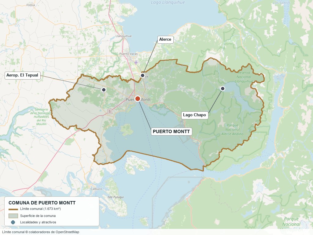
Communal boundary based on OpenStreetMap open data
§ 03 Location, Geography and Territory View
Where Puerto Montt is, what it is built on, and why its waterfront determines everything.
3.1 Location
Puerto Montt lies 1,055 km south of Santiago, at the point where Ruta 5 Sur stops being a continuous road: from here the Pan-American Highway continues to Pargua, crosses the Canal de Chacao by ferry and runs the length of Chiloé to its final marker in Quellón. It borders Puerto Varas to the north, Cochamó to the east, Calbuco to the southwest and Maullín and Los Muermos to the west. It is 20 km from Puerto Varas, 110 km from Osorno and about 13 km from El Tepual airport.
Civic center · 41°28′S 72°56′W
3.2 Terrain and setting
The original name says it all: Melipulli means four hills, and the city is built climbing those slopes from the waterline. That amphitheater-like topography shapes local urban design —steep streets, natural lookouts, a marked contrast between the waterfront and the upper city— and also land values, because a view over the Seno de Reloncaví is an asset that is very unevenly distributed.
The commune extends from the coast inland, covering the southern end of the Central Valley (Depresión Intermedia). To the north lies Lago Llanquihue; to the east, the Andes with the Osorno and Calbuco volcanoes; to the south and west, the inland sea that opens onto the Golfo de Ancud and separates the mainland from Chiloé.
3.3 Waterfront and islands
Main features of the maritime edge5 rows
| Feature | Role in the territory |
|---|---|
| Seno de Reloncaví | The city's maritime front and gateway to the inland sea. It shapes the port, the coastal avenue, Angelmó and all waterfront real estate development. |
| Canal Tenglo | Arm of the sea between the city and Isla Tenglo; a natural shelter that houses the main port, operated by Empormontt, and most of the shipyards. |
| Isla Tenglo | Island facing downtown, reached by boat; lookouts, restaurants and a low-density residential area with direct views of the city. |
| Estuario de Reloncaví | Fjord reaching inland to the east (Cochamó); an area of aquaculture concessions and fjord-and-mountain scenery. |
| Lago Chapo | In the east of the commune, near Parque Nacional Alerce Andino; it feeds the Canutillar hydroelectric plant and is a focus of rural parcel (parcela de agrado) subdivisions. |
3.4 Soils and land suitability
The commune's soils are volcanic in origin, with a significant presence of ñadis —thin soils over an impermeable hardpan layer known as fierrillo— especially toward Alerce and the western plain. These soils drain poorly and flood in winter, which constrains both farming and construction.
- Advantage: proximity to the largest services market in the south; any well-connected lot finds demand.
- Limitation: ñadis require drainage works and raise development costs; the commune's agricultural potential is marginal compared with Osorno or Puerto Octay.
- Risk: winter waterlogging in flat, poorly drained areas; it is best to visit the land in July, not in January.
- Real estate implication: here land is valued not for what it produces but for where it is. Proximity to downtown, the airport, Ruta 5 or the waterfront explains price far better than agronomic quality.
§ 04 Climate and Seasonality View
The city of eternal winter: not because of the cold, but because it never quite stops raining.
Puerto Montt has a rainy temperate oceanic climate (Cfb), with abundant rainfall all year round, cool summers and mild but very wet winters. The mean annual temperature is around 10.6 to 11 °C and the range between the warmest and coldest months is only about 8 °C: the sea moderates extremes in both directions.
Reference climate parameters10 rows
| Parameter | Typical value | Comment |
|---|---|---|
| Mean annual temperature | ≈10.6 – 11 °C | Very stable from year to year |
| January mean (summer) | ≈14.9 °C | Highs around 20 °C; above 30 °C is exceptional |
| July mean (winter) | ≈7.0 °C | Mean lows close to 4.8 °C |
| Annual precipitation | ≈1,600 – 1,800 mm | Sources differ significantly (see section 22) |
| Wettest month | June | ≈220 mm |
| Driest month | February | ≈70 mm; no month falls below that floor |
| Rainy days (August) | ≈21.7 days | Annual maximum; February is the minimum with ≈10 days |
| Relative humidity | 77 % – 87 % | Highest from May to August, lowest in January |
| Hours of sunshine per year | ≈1,585 – 1,985 hours | January is the sunniest month |
| Snow | Very rare in the city | Exceptional episodes, such as August 1995 and 2020 |
June brings three times as much rain as February, but what matters is not the peak but the floor: not a single month falls below 70 mm. That is why Puerto Montt is called the city of eternal winter —not because it is very cold, but because it almost never stops raining entirely.
The most significant medium-term phenomenon for the local economy is not rain but sea temperature: harmful algal blooms, associated with episodes of warming water, have caused mass mortalities at farming sites and are today the main climate risk for the industry that sustains the commune.
§ 05 History: from Melipulli to the Salmon Capital View
A city founded by decree to receive settlers, flattened by the largest earthquake ever recorded, and reinvented by an industry no one had imagined.
-
Pre-1853
Melipulli
The Huilliche people know the site as Melipulli, 'four hills' in Mapudungun. It is a crossing point between the inland sea and Lago Llanquihue, and an area of dense alerce and coigüe forest.
-
1852
The trail from the lake
Vicente Pérez Rosales, colonization agent, opens the trail between Lago Llanquihue and the Seno de Reloncaví, seeking an outlet to the sea for the settlers already established on the lakeshore.
-
1853
Founded
On 12 February the city is officially founded under the name Puerto Montt, in honor of President Manuel Montt. The first inhabitants are German families who arrived under the Colonization Law, along with Chilotes and Huilliches already living in the area.
-
1861
Provincial capital
Puerto Montt is designated capital of the newly created Llanquihue Province, consolidating its administrative role over a territory that until then had depended on Chiloé.
-
1912
The railway arrives
After construction began in 1907, the rail line from Osorno enters service: first for passengers and, from 1913, for freight. The city is integrated into the national market and becomes the shipping port for the south's production.
-
1920–1950
Timber and coastal shipping port
The economy revolves around alerce, timber, small-scale fishing and coastal shipping to Chiloé and the channels. Angelmó becomes established as a fishing cove and market. Between 1921 and 1931 there is even a horse-drawn tram.
-
1960
The Valdivia earthquake
The magnitude 9.5 quake —the largest ever recorded— and the tsunami that followed destroy much of the city and cause the waterfront to subside. Reconstruction completely redefines Puerto Montt's urban appearance.
-
1974
The Los Lagos Region is born
Regionalization makes Puerto Montt a regional capital, adding to its provincial role the administration of a territory that would come to include Chiloé, Llanquihue, Osorno and Palena.
-
1976
The Carretera Austral begins
Work begins on Ruta 7, which will link Puerto Montt with continental Patagonia. The city officially becomes the starting point of the southern highway and the logistics base for everything that lies to the south.
-
1980s
Salmon arrives
The first salmonid farming sites are set up in the inland sea. The stable temperature and sheltered fjords prove ideal, and within a few years the activity displaces timber as the economic engine.
-
2007–2010
The ISA virus crisis
The ISA virus outbreak, detected at a farm on Isla Lemuy, triggers a health and social crisis: more than 15,000 direct jobs lost and a 20% drop in Atlantic salmon exports. Production does not return to previous levels until 2012.
-
2015
U-17 World Cup and visibility
The Estadio Regional de Chinquihue, on the shore of the Canal Tenglo, hosts the FIFA U-17 World Cup, strengthening the city's sports infrastructure.
-
2025
Census and population record
The 2024 Census confirms 277,040 inhabitants and 12.7% growth, making Puerto Montt the fifth most populous regional capital in the country. That same year Chilean aquaculture reaches a record 1.5 million tonnes harvested, with Puerto Montt as the main aquaculture and fishing hub of the Los Lagos Region.
-
2026
Innovation Capital of Patagonia
The municipality launches the Innova Puerto Montt plan, which seeks to bring academia, the public sector and industry together around biotechnology and aquaculture innovation, with AquaSur 2026 and the Semana del Salmón (Salmon Week) as showcases for the city's positioning.
§ 06 Cultural Identity and Indigenous Peoples View
A city of three origins that also receives more migrants than any other commune in this series.
According to the Social Household Registry (Registro Social de Hogares) of March 2025, 18.3% of Puerto Montt's population identifies as belonging to an Indigenous people, far above the national average (9.2%) though below the regional figure (26.0%). The majority affiliation is Mapuche-Huilliche, present in the territory since long before any European settlement existed.
The migration figure is just as significant: 6.7% of the population was born abroad, well above the regional average (4.0%). In absolute terms that is 18,588 people, and compared with the 2017 Census the resident foreign population grew by more than 400%. It is a city that attracts workers, not only from the rest of Chile but from abroad.
The cultural layers of Puerto Montt4 rows
| Tier | Visible traces today |
|---|---|
| Huilliche | The founding place name Melipulli ('four hills'); communities present in the commune's rural area; the surrounding place names (Chinquihue, Pelluco, Tenglo, Chapo, Reloncaví). |
| Chilote | The dominant popular layer: sustained migration from the archipelago to the mainland. It brought the cuisine of seafood and potatoes, curanto, the traditional boatbuilding of Angelmó and much of the labor that built the city. |
| German (1853 colonization) | Surnames and architecture of the first settlers; the Iglesia de los Padres Jesuitas and its bell tower; the monument to Vicente Pérez Rosales; a tradition of trade and crafts that shaped the historic center. |
| Recent migrants | Venezuelan, Haitian and Colombian communities that arrived over the last decade, concentrated in the fastest-growing areas; their presence is reflected in commerce, services and the processing industry. |
§ 07 Key Demographic Data View
7.1 Population and growth
Demographic indicators compared9 rows
| Indicator | Puerto Montt commune | Los Lagos Region | Country |
|---|---|---|---|
| Population, 2017 Census | 245,902 | 828,708 | 17,574,003 |
| Population, 2024 Census | 277,040 | 890,284 | 18,480,432 |
| Intercensal change | 12.7 % | 7.4 % | 5.2 % |
| Commune area | 1,673.0 km² | — | — |
| Population density (2024) | ≈166 inhab./km² | — | — |
| Foreign-born population | 6.7 % (18,588) | 4.0 % | 8.7 % |
| Sex ratio 2024 | 97.2 | 96.5 | 94.3 |
| Demographic Dependency Ratio (IDD) 2024 | 40.5 | 45.3 | 46.5 |
| Elderly Index (IAM) 2024 | 55.7 | 75.8 | 79.0 |
7.2 Age structure (2024 Census)
Population distribution by age group5 rows
| Age group | Census 2017 | 2024 Census | % Commune 2024 |
|---|---|---|---|
| 0 to 14 years | 53,499 | 51,260 | 18.5 % |
| 15 to 29 years | 60,747 | 62,493 | 22.6 % |
| 30 to 44 years | 55,195 | 68,149 | 24.6 % |
| 45 to 64 years | 55,509 | 66,587 | 24.0 % |
| 65 years and over | 20,952 | 28,551 | 10.3 % |
Puerto Montt is the exact opposite of Puerto Octay. While that commune is losing population and its aging index reaches 100, here the population grows 12.7% and the same index stands at 55.7, far below the regional (75.8) and national (79.0) averages. The Demographic Dependency Ratio (40.5) is also the lowest of the three territorial levels: there are more working-age people per dependent than in any other commune in this series.
The engine of that growth is the arrival of young adults: the 30 to 44 age group added almost 13,000 people between censuses. It is the profile of a city that offers jobs. The flip side is that the 0 to 14 age group shrank in absolute terms, a sign that growth comes from migration rather than births.
§ 08 Economic and Socioeconomic Data View
8.1 Poverty and social indicators (CASEN and Social Household Registry)
Comparative social indicators7 rows
| Indicator | Puerto Montt commune | Los Lagos Region | Country |
|---|---|---|---|
| Income poverty, Casen 2017 | 11.4 % | 11.6 % | 8.5 % |
| Income poverty, Casen 2022 | 6.5 % | 7.0 % | 6.5 % |
| Multidimensional poverty, Casen 2022 | 15.5 % | 19.7 % | 16.9 % |
| People in households lacking basic services (Mar. 2025) | 12.8 % | 23.1 % | 13.1 % |
| Overcrowded households (Mar. 2025) | 7.3 % | 7.5 % | 8.1 % |
| Indigenous population (RSH, Mar. 2025) | 18.3 % | 26.0 % | 9.2 % |
| Foreign population (RSH, Mar. 2025) | 4.2 % | 2.3 % | 6.7 % |
Income poverty fell from 11.4% to 6.5% between 2017 and 2022, landing exactly on the national average after having been almost three points above it. Multidimensional poverty (15.5%) is lower than both the national (16.9%) and regional (19.7%) rates. Lack of basic services (12.8%) is practically equal to the national average and far below the regional one (23.1%), reflecting a mostly urban commune.
8.2 Economic activity (SII) and municipal finances (SINIM)
Business structure and municipal finances10 rows
| Economic indicator (SII / SINIM) | Value |
|---|---|
| Number of active businesses, commune (2023) | 24,690 |
| Reported salaried employees (2023) | 152,923 |
| Sector with the most workers (2023) | Agriculture, livestock, forestry and fishing — 29,308 workers |
| Sector with the most companies (2023) | Wholesale and retail trade — 7,070 companies |
| Other sectors by number of workers | Administrative and support services (23,214); trade (21,124); transport and storage (16,994); manufacturing (14,689); construction (13,080); health (10,538) |
| Total municipal revenue received, 2024 | $81,164,228 (thousands of $) |
| Permanent own-source revenue (IPP) as a share of total revenue, 2024 | 52.8 % |
| Share of the Municipal Common Fund, 2024 | 32.4 % |
| Revenue from aquaculture licenses (Law 20,033), 2024 | $305,106 (thousands of $) |
| Property tax for municipal benefit, 2024 | $12,180,625 (thousands of $) |
The employment structure reveals the real weight of the sea: the “agriculture, livestock, forestry and fishing” sector accounts for 29,308 workers, more than any other, and in this commune it overwhelmingly means aquaculture and fishing, not farming. Add manufacturing (14,689 workers, largely in processing plants) and transport and storage (16,994), and the salmon value chain explains a decisive share of the commune's formal employment.
In municipal finances, Puerto Montt shows the greatest autonomy in this series: permanent own revenues represent 52.8% of the budget, and dependence on the Municipal Common Fund (32.4%) has been falling since 2022. Aquaculture licenses contribute $305 million a year, a source that only appears in communes with concessions in the inland sea.
§ 09 The Economic Engine: Salmon and the Port View
In forty years the city went from living off timber to being the core of Chile's second-largest export industry.
9.1 Salmon farming: the heart of the national industry
Established in the area since the eighties, salmon farming is today the main economic activity of the Los Lagos Region. Puerto Montt is the core of that industry: it is the operating base of the largest producers and concentrates processing plants, suppliers, specialized shipping companies and the sector's technical services.
The scale is best understood first at the national level. In 2025 Chilean aquaculture harvested 1,525,400 tonnes, of which 815,300 t were Atlantic salmon (+16.0% year on year) and 281,400 t coho salmon (+21.6%). Much of that production is managed, processed and shipped from this commune, which the INE monthly bulletins consistently rank as the main aquaculture and fishing hub of the Los Lagos Region.
The salmon industry in figures9 rows
| Indicator | Value | Source and year |
|---|---|---|
| National aquaculture harvest | 1,525,400 tonnes | Statistical Yearbook of Fisheries and Aquaculture, Sernapesca, 2025 |
| Atlantic salmon | 815,300 tonnes | 2025; +16.0% year on year |
| Coho salmon (Pacific) | 281,400 tonnes | 2025; +21.6% year on year |
| Position of the commune | Main aquaculture and fishing hub of Los Lagos | Monthly landing bulletins, INE Los Lagos, 2025-2026 |
| Share of salmonids in fishery exports | 72 % of export value | Sectoral Report on Fisheries and Aquaculture, SUBPESCA, 2025 |
| National fishery and aquaculture exports | US$ 7,664.9 million | As of October 2025; +5.4% in value and +15% in volume |
| Chile's position | World's 2nd largest producer of Atlantic salmon | Behind Norway; world's 1st producer of coho salmon |
| Fishing and aquaculture workers in the commune | 29,308 | SII, 2023; the sector with the most jobs in the commune |
| Aquaculture license fees paid to the municipality | $305 million per year | SINIM 2024, Law 20,033 |
The industry also carries a memory of crisis. The ISA virus outbreak between 2007 and 2010 cost more than 15,000 direct jobs and sank exports by 20%, with severe social effects across the area. That experience explains much of today's sanitary regulatory framework and the local sensitivity to any environmental event.
9.2 Port, shipyards and southern logistics
The main port, on the Canal Tenglo and operated by Empormontt, fulfills a role no other Chilean city can replace: it is where overland cargo is transferred to ships to supply an archipelago without continuous roads. Ferries leave from here for Chiloé, Chaitén, Puerto Chacabuco and Puerto Natales, and a shipyard and maritime services industry operates here, linked both to cargo transport and to the transport of live fish.
Transport and storage employs 16,994 people in the commune, a figure that only makes sense given this role as a logistics hinge between the mainland and insular Patagonia.
9.3 Tourism: a gateway, not a final destination
Puerto Montt receives a large but transient tourist flow: it is the airport, bus terminal and port through which people pass on their way to Puerto Varas, Chiloé, the Carretera Austral or southern cruises. The accommodation and food service sector totals 1,447 companies and 3,564 workers, modest figures compared with the weight of salmon.
The municipality has sought to reverse this corridor status with the Semana del Salmón, a food festival that aims to replicate the model of Bariloche a la Carta or Oktoberfest, with a circuit of more than 50 restaurants in Angelmó, Isla Tenglo, Pelluco, Valle Volcanes, Alerce and Lago Chapo.
9.4 Other pillars
- Trade: 7,070 companies and 21,124 workers; Puerto Montt is the shopping center for the entire southern macro-zone.
- Construction: 2,733 companies and 13,080 workers, sustained by urban growth and industrial demand.
- Health and education: 733 and 304 companies respectively; as regional capital, it concentrates the specialized services of a very large territory.
- Mussel farming and seaweed: cultivation of chorito mussels and pelillo (Gracilaria) in the inland sea, complementing salmon farming.
- Innovation: the Innova Puerto Montt plan seeks to position the city as a hub for aquaculture biotechnology, with AquaSur as its international showcase.
§ 10 Real Estate Market View
10.1 An urban market, not a leisure market
Puerto Montt has the deepest and most diversified real estate market in this series, and also the most urban. Here the dominant product is not the rural parcel but the apartment and the house in a gated community, sustained by housing demand from people who work in the city. The commune has 784 real estate companies, more than any other in this series.
Population growth —31,000 more people in seven years— and the expansion of Alerce, a satellite town north of the urban area, have been the two drivers of recent residential development.
10.2 Property types in the local market
Segments of the communal real estate market6 rows
| Segment | Where it is concentrated | Demand profile |
|---|---|---|
| Apartments | Downtown, waterfront and upper city | First homes, buy-to-let investment and industry executives |
| Houses in gated communities | Valle Volcanes, eastern sector and upper Puerto Montt | Families with children; the most sought-after segment given the age structure |
| Social and integrated housing | Alerce and northern expansion areas | High demand; Alerce is the largest focus of housing growth |
| Properties overlooking the Seno de Reloncaví | Pelluco, coastal avenue, Isla Tenglo, road to Chinquihue | Premium; the view is the dominant price factor |
| Rural parcels (parcelas de agrado) | Lago Chapo, road to Cochamó, eastern rural sector | Second homes and tourism; a minor segment compared with the urban market |
| Industrial and logistics land | Ruta 5, road to El Tepual, port area | Processing plants, warehouses and services for the aquaculture industry |
10.3 What drives prices in Puerto Montt
Value drivers in this market, ranked by impact7 rows
| Factor | Price impact | How to check it here |
|---|---|---|
| View over the Seno de Reloncaví | Very high | Check on site and review the building height allowed on the lots between the property and the sea |
| Location relative to downtown and the Ruta 5 corridor | Very high | Actual rush-hour travel time, not distance |
| Land use permitted by the PRC | High | Certificate of Prior Information (Certificado de Informaciones Previas) from the DOM: the commune mixes residential, industrial and port uses in close proximity |
| Soil quality and drainage | High | Ñadis require additional works; visit the land in winter |
| Proximity to processing plants or industrial zones | Mixed | Adds value for logistics use, reduces it for residential use |
| Connectivity to El Tepual and Alerce | High and changing | It is the main road bottleneck acknowledged by the municipality; road projects may shift values |
| Individual tax roll number and municipal final approval | Critical | Require individual registration and final approval (recepción final) from the DOM |
§ 11 Land-Use Planning in Puerto Montt View
What this commune's planning instrument specifically allows and prohibits.
Puerto Montt's Communal Zoning Plan (PRC) lists 2009 as its year of legal approval according to the SINIM 2024 report, making it the most modern instrument among the communes in this series —Osorno and Natales operate with plans from the nineties or earlier. The commune also has a sectional plan approved after the current plan, and a PLADECO (communal development plan) drawn up in 2017.
Planning instruments in force4 rows
| Instrument | Status | Implication |
|---|---|---|
| Communal Zoning Plan | In force; legally approved in 2009 | Defines the urban boundary, uses and densities using criteria that postdate the salmon boom; the most up-to-date in this series |
| Sectional plans | 1 approved after the PRC | Allows specific areas to be regulated in greater detail |
| PLADECO | Drawn up in 2017 | Predates the demographic jump of the 2024 Census |
| Municipal geoportal | Active web platform | The municipality publishes communal geographic information online, a resource that is uncommon at this level |
Puerto Montt's regulatory peculiarity lies not in the age of its plan but in the coexistence of uses: it is at once a residential city, a port, an industrial processing hub and an administrative capital. Here the Certificate of Prior Information is more decisive than in any other commune in the series, because the difference between a residential and an industrial lot can be a single block.
§ 12 Sectors and Localities View
Puerto Montt is organized around a narrow downtown by the sea and an expansion that climbs the hills and spreads north and east.
Sectors of the commune and their profile8 rows
| Sector | Features | Market profile |
|---|---|---|
| Downtown and waterfront | Civic, commercial and administrative core facing the Seno; cathedral, bus terminal, regional public services. | Apartments, offices and shops; high rental turnover |
| Angelmó | Historic fishing cove, seafood and crafts market; port and shipyards; the most emblematic place in the city. | Commercial and tourist; scarce and highly contested land |
| Pelluco | Seaside resort to the east, along the coastal avenue; dining and residential hub with sea views. | Higher-end housing and urban second homes |
| Valle Volcanes | Residential expansion area to the north, consolidated over the last two decades; has its own dining hub. | Houses in gated communities; the most active family segment |
| Alerce | Satellite town to the north, the commune's largest focus of housing growth; young population. | Social and integrated housing; high demand, poor connectivity |
| Isla Tenglo | Island facing downtown, reached by boat; low density, lookouts and restaurants. | Niche with high scenic value and limited access |
| Chinquihue | Corridor running west along the waterfront; regional stadium, fishing coves and port activity. | Mixed: sports, industrial-port and scattered residential |
| Lago Chapo and rural eastern sector | Rural area toward Parque Nacional Alerce Andino; lake, native forest and low density. | Rural parcels and nature tourism |
§ 13 Basic Services, Utilities and Digital Connectivity View
Urban coverage is solid; the challenge lies in infrastructure that did not keep pace with population.
12.8% of the population lives in households lacking basic services, practically equal to the national average (13.1%) and far below the regional one (23.1%). Within the consolidated urban area, coverage of drinking water, electricity and sewerage is fully in place.
Service providers and coverage8 rows
| Service | Status | Practical notes |
|---|---|---|
| Electricity | Grupo SAESA; interconnected grid | Unlike Magallanes, the region is connected to the National Electric System. The Canutillar hydroelectric plant, on Lago Chapo, provides local generation |
| Urban drinking water | Consolidated sanitation network | Full urban coverage; check feasibility in recently developed areas |
| Rural drinking water | APR committees and cooperatives | In the eastern rural sector and toward Lago Chapo, the solution is APR (rural drinking water) or a well with DGA water rights |
| Sewerage | Consolidated urban network | In rural subdivisions, a septic tank authorized by the SEREMI de Salud (regional health authority); pay attention to the poor drainage of ñadi soils |
| Gas | LPG and partial household gas network | There is no regional natural gas as in Magallanes; LPG and firewood predominate |
| Heating | Firewood, pellets, gas and electric | The commune is subject to air quality regulations for particulate matter; certified equipment is advisable |
| Internet and phone | Urban fiber optics; 4G/5G | The best digital connectivity in this series, consistent with its role as regional capital |
| Waste collection | Urban municipal service | Partial coverage in the extensive rural sector |
§ 14 Health View
The most complete network in the entire far south: 89 facilities that serve the commune and act as a referral center for the macro-zone.
Puerto Montt has 89 health facilities, the densest network in this series and one of the most complete in southern Chile. As regional capital, its hospital is the high-complexity referral center for a territory that includes Chiloé, Palena and much of the Los Lagos Region, and it also receives referrals from Aysén.
Health network of the commune (April 2025)10 rows
| Type of facility | Number | Remarks |
|---|---|---|
| Hospital | 1 | Hospital Base de Puerto Montt: high complexity and macro-zone referral center |
| Family Health Center (CESFAM) | 7 | Municipal primary care network |
| Primary Emergency Care Service (SAPU) | 4 | Plus 1 high-resolution SAR |
| Rural Health Post (PSR) | 12 | Coverage for the commune's extensive rural sector |
| Community Family Health Center (CECOSF) | 5 | Neighborhood-level care |
| Community Mental Health Center (COSAM) | 2 | Plus 1 child and adolescent day hospital |
| Private clinics | 6 | Plus 17 private health centers and 6 dental clinics |
| Clinical laboratories | 14 | The largest diagnostic capacity in the macro-zone |
| Dialysis centers | 2 | High-complexity service available locally |
| Health Service Directorate | 1 | Headquarters of the Servicio de Salud del Reloncaví |
Comparative health indicators (2022)5 rows
| Indicator | Commune | Region | Country |
|---|---|---|---|
| Validated population enrolled in primary care (APS) (2023) | 225,215 | 805,450 | 15,051,673 |
| Birth rate (per 1,000 inhab.) | 10.7 | 9.9 | 9.6 |
| Total fertility rate | 1.4 | 1.4 | 1.3 |
| Crude death rate (per 1,000 inhab.) | 6.3 | 7.9 | 6.9 |
| Infant mortality rate (per 1,000 live births) | 5.1 | 5.4 | 5.9 |
Indicators are consistently better than regional ones: overall mortality (6.3) is the lowest of the three territorial levels and infant mortality (5.1) is below the national average. The birth rate, at 10.7 per thousand, is the highest in the comparison, consistent with a young population.
§ 15 Education View
15.1 School education
The commune has 160 schools (2024): 76 municipal, 79 state-subsidized private and 5 fee-paying private, with total enrollment of 57,698 students. Unlike Natales, Puerto Montt has not transferred its schools to the Local Public Education Service: they are still run by the municipality through its own department.
SIMCE 2024 results (preliminary)6 rows
| SIMCE 2024 test | Commune | Region | Country |
|---|---|---|---|
| 4° básico (Grade 4) — Reading | 277 | 276 | 278 |
| 4° básico (Grade 4) — Mathematics | 262 | 261 | 264 |
| 6° básico (Grade 6) — Reading | 249 | 248 | 249 |
| 6° básico (Grade 6) — Mathematics | 244 | 243 | 245 |
| 2° medio (Grade 10) — Reading | 250 | 276 | 249 |
| 2° medio (Grade 10) — Mathematics | 256 | — | 259 |
Results are practically on the national average at all levels assessed, slightly exceeding the regional average in most tests. It is the strongest educational performance in this series: Osorno stands out above the average, but Natales and Puerto Octay fall clearly below it.
15.2 Higher education
As regional capital, Puerto Montt has the widest range of higher education in the far south: campuses of the Universidad Austral de Chile, Universidad de Los Lagos, Universidad San Sebastián, Universidad Santo Tomás and INACAP, as well as technical training centers. Enrollment in technical-vocational secondary education in the commune reaches 4,135 students.
§ 16 The Inland Sea and Natural Surroundings View
Puerto Montt sits exactly where three distinct landscapes meet: the inland sea with its islands, the volcanic Andes with their lakes, and the temperate rainforest of ancient alerces.
Natural attractions by distance7 rows
| Attraction | Approx. distance | Activities |
|---|---|---|
| Parque Nacional Alerce Andino | ≈40 km to the east | Forest of ancient alerces, trails, lagoons; one of the largest concentrations of alerce in the country |
| Lago Chapo | ≈40 km | Fishing, kayaking, rural parcels; feeds the Canutillar plant |
| Estuario de Reloncaví and the Reloncaví fjord | From the city toward Cochamó | Boat trips, marine wildlife watching, hot springs and trekking in Cochamó |
| Isla Tenglo | Facing downtown, by boat | Lookouts, local food and a short outing from Angelmó |
| Osorno and Calbuco volcanoes | ≈60–70 km to the northeast | Skiing, mountaineering and lookouts; visible from the city on clear days |
| Lago Llanquihue | ≈20 km to the north | Beaches and the Interlagos circuit, shared with Puerto Varas, Llanquihue and Frutillar |
| Chiloé | Crossing via the Canal de Chacao | Gateway to the archipelago; ferries from Pargua |
Seno de Reloncaví, Osorno and Calbuco volcanoes, Lago Llanquihue and Alerce Andino
§ 17 Connectivity and Transportation View
17.1 Road network
Puerto Montt is where Ruta 5 stops being a continuous road and where Ruta 7, the Carretera Austral, begins. The Pan-American Highway does not end here: it continues southwest to Pargua, crosses the Canal de Chacao by ferry and runs through Chiloé to the Hito Cero (kilometer zero marker) in Quellón, its southern end after some 3,363 km from Arica. But the last uninterrupted overland stretch ends in this commune, and that status as both an end and a beginning defines its logistics role.
Routes and distances8 rows
| Route / destination | Distance and details |
|---|---|
| Ruta 5 Sur | 1,055 km from Santiago; last continuous overland stretch. Continues to Pargua (≈55 km) and, after the Chacao ferry crossing, to Quellón |
| Ruta 7 (Carretera Austral) | Starts in Puerto Montt and heads toward Hornopirén, Chaitén and continental Patagonia |
| Puerto Varas | 20 km to the north, ≈25 min |
| Osorno | 110 km to the north, ≈1 h 15 min |
| El Tepual Airport | ≈13 km to the west |
| Pargua (crossing to Chiloé) | ≈55 km to the southwest; ferry across the Canal de Chacao |
| Santiago | 1,055 km to the north via Ruta 5 |
| Bariloche (Argentina) | ≈310 km via the Cardenal Samoré pass |
From the end of the continuous road to the archipelago: Pargua, Canal de Chacao and Chiloé
17.2 Airport
El Tepual Airport (PMC), about 13 km from the city, is the main air terminal in southern Chile after Temuco and the most important in the entire southern macro-zone. It operates daily flights to Santiago and connections to Balmaceda, Punta Arenas and Chiloé, as well as charter traffic linked to the aquaculture industry. It is the air gateway to northern Patagonia.
17.3 Port and maritime transport
- Empormontt: main port on the Canal Tenglo; general cargo, containers and services for the aquaculture industry.
- Ferries: departures to Chaitén, Puerto Chacabuco and Puerto Natales, plus coastal shipping to the archipelago; the voyage through the channels is a tourist experience in itself.
- Cruises: regular calls by international cruise ships during the summer season.
- Shipyards and maritime services: an established shipbuilding and repair industry, linked both to cargo transport and to live fish transport.
- Bus terminal: national and international connections; the overland hub for the whole macro-zone.
§ 18 Tourism: Development, Attractions and Things to Do View
18.1 Tourism development
Tourism in Puerto Montt has a peculiarity: the city receives a huge flow of visitors, but mostly in transit, heading to Puerto Varas, Chiloé or the Carretera Austral. The accommodation and food sector totals 1,447 companies and 3,564 workers, modest figures compared with the 29,308 people in fishing and aquaculture.
The municipal strategy has been to build a tourism identity of its own around the industry that defines the city: the Semana del Salmón, organized together with the Consejo del Salmón, SalmonChile and Universidad Santo Tomás, aims to position Puerto Montt as the world salmon capital with a circuit of more than 50 restaurants, following the model of Bariloche a la Carta.
18.2 City attractions
- Angelmó: fishing cove, seafood market and crafts fair; the most emblematic place in Puerto Montt, where you eat curanto and buy Chilote weaving and basketry.
- Coastal avenue and seafront promenade: waterfront with views of the Seno de Reloncaví and Isla Tenglo.
- Iglesia de los Padres Jesuitas and its bell tower: architectural heritage of the historic center.
- Catedral de Puerto Montt: the city's main church, facing the Plaza de Armas and built of alerce wood.
- Monument to Vicente Pérez Rosales: a tribute to the colonization agent who founded the city.
- Monument to German Colonization: sculpture facing the Plaza de Armas, dedicated to the first German settlers who arrived in the region.
- Casa Pauly: heritage building from the early twentieth century, declared a National Monument and now a Cultural Interpretation Center.
- Mercado Presidente Ibáñez: the city's traditional market, with local shops and fresh everyday produce.
- Sentados frente al mar: a sculpture group on the coastal avenue (its name means “Sitting facing the sea”) that has become one of Puerto Montt's visual symbols and a popular photo spot.
- Isla Tenglo: boat crossing from Angelmó; lookouts over the city and seafood restaurants.
- Pelluco: seaside resort and dining hub east of the city, with open sea views.
- Estadio Regional de Chinquihue: venue of the 2015 U-17 World Cup, overlooking the Canal Tenglo; one of the southernmost stadiums in the world.
18.3 Excursions from the city
- Parque Nacional Alerce Andino: forest of ancient alerces about 40 km away; trails and lagoons.
- Monumento Natural Lahuen Ñadi: a protected area near Puerto Montt that preserves a forest of ancient alerces, with trails to explore it.
- Fiordo de Reloncaví and Cochamó: boat trips and trekking in the Cochamó valley, known for its granite walls.
- Lakes and volcanoes circuit: Puerto Varas, Frutillar, Llanquihue, the Saltos del Petrohué and Osorno volcano, all less than an hour away.
- Chiloé: crossing via the Canal de Chacao to Ancud and Castro.
- Carretera Austral: first stretch toward Hornopirén and continental Patagonia.
18.4 Food and dining
Puerto Montt's cuisine is maritime and Chilote, with salmon added as a recent emblem.
- Curanto: the signature dish of the island south, cooked in a pit over hot stones; shellfish, meats, milcao and chapalele.
- Cancato de salmón: salmon split open, stuffed and grilled; the local dish most closely associated with the city's productive identity.
- Angelmó seafood: choritos (mussels), machas (razor clams), sea urchins and centolla (king crab), straight from the market.
- Chilote cuisine: milcao, chapalele, fried fish and caldillos (fish soups) at the market's eateries.
- Dining hubs: Angelmó, Pelluco, Valle Volcanes, Isla Tenglo and Alerce concentrate most of the restaurants.
18.5 Calendar and events
Main events of the year5 rows
| Period | Event | Character |
|---|---|---|
| January – February | High season and cruises | Peak tourist influx; international cruise calls |
| 12 February | City anniversary | Commemoration of the 1853 founding |
| July – August | Semana del Salmón (Salmon Week) | Food circuit with more than 50 restaurants; it aims to become the south's major winter event |
| Biennial | AquaSur | International aquaculture fair; the largest of its kind in the Southern Hemisphere |
| Year-round | Deportes Puerto Montt | Los Delfines play at the Estadio Regional de Chinquihue; they were promoted to Primera B in 2025 |
§ 19 Daily Life, Safety and Practical Information View
What you need to know if you are going to live in Puerto Montt, not just pass through.
19.1 Safety
Reported crime rates per 100,000 inhabitants2 rows
| Indicator | Commune 2022 | Commune 2024 | Region 2024 | Country 2024 |
|---|---|---|---|---|
| Violent crime | 2,635.8 | 2,378.7 | 2,197.5 | 2,222.7 |
| Domestic violence | 1,062.5 | 940.0 | 884.5 | 601.0 |
This is the commune's weakest indicator. The violent crime rate (2,378.7) exceeds both the regional and national averages, and the domestic violence rate (940.0) is more than 56% above the national average (601.0). The positive news is the trend: both indicators have been falling since 2022, when they reached 2,635.8 and 1,062.5 respectively.
19.2 Participation and civic life
In the final electoral roll of October 2024 the commune had 207,856 registered voters and a turnout of 85.8%, higher than both the regional (84.4%) and national (84.9%) averages and well above Natales (70.2%). Foreign voters make up 2.4% of the roll.
19.3 Where to handle paperwork
Offices based in Puerto Montt6 rows
| Office | Status | Remarks |
|---|---|---|
| Municipality of Puerto Montt (Ilustre Municipalidad) | Based in the city | Municipal Works Department (Dirección de Obras Municipales); also runs a public Geoportal with communal geographic information |
| Real Estate Registrar (Conservador de Bienes Raíces) | Based in the city | As regional capital, it has its own Real Estate Registrar (Conservador de Bienes Raíces) |
| Notary offices | Several in the city | The widest choice of notaries in the macro-zone |
| Regional services (SEREMI, SII, SERVIU, Regional Government) | Based in the city | As regional capital, all regional-level procedures are handled locally |
| Hospital Base de Puerto Montt | Based in the city | High complexity; macro-zone referral center |
| Undersecretariat for the Armed Forces | National procedure | Needed to verify maritime concessions along the shoreline |
19.4 Cost of living and practical considerations
- Housing costs are higher than in the other communes in this series, a direct consequence of urban demand sustained by employment.
- The range of services —shopping, health, higher education, paperwork— is the most complete in the far south, so there is almost nothing you have to travel for.
- Heating costs are significant from April to September, made worse by constant humidity; insulation matters more than heating power.
- Rush-hour commute times are the most frequently cited everyday problem, especially on the routes to Alerce and El Tepual.
- Employment seasonality is low compared with tourist communes: the aquaculture industry operates year-round, which gives the rental market stability.
§ 20 Territorial Analysis: Strengths, Challenges and Opportunities View
An honest reading of the territory. A sound investment decision also requires knowing what doesn't work.
- Population growth of 12.7% between censuses, more than double the national average: the fastest-growing commune in this series.
- The youngest population in the series: only 10.3% are over 65, compared with 14.0% nationally, with the lowest dependency ratio (40.5).
- Core of the salmon industry, which accounts for about 72% of the export value of the national fishing sector.
- Fishing and aquaculture employ 29,308 people; the commune accounts for around 40% of the region's formal employment.
- Highest municipal financial autonomy in the series: 52.8% permanent own revenue, with declining dependence on the FCM (Municipal Common Fund).
- Health network of 89 facilities with its own high-complexity hospital: no need to travel for anything.
- SIMCE results in line with the national average at all levels assessed.
- Communal Zoning Plan from 2009, the most up-to-date among the communes in this series.
- Electoral turnout of 85.8%, above the regional and national averages.
- Domestic violence rate of 940.0 per 100,000 inhabitants, more than 56% above the national average.
- Violent crime (2,378.7) above the regional and national averages, although declining since 2022.
- Road infrastructure that did not keep pace with population: the municipality itself calls connections to El Tepual and Alerce urgent.
- Extreme economic concentration in salmon farming, with a recent memory of crisis: the ISA virus cost more than 15,000 jobs between 2007 and 2010.
- Mostly transit tourism, capturing little value compared with Puerto Varas or Chiloé.
- The 0 to 14 age group shrank in absolute terms: growth is driven by migration, not natural increase.
- Difficult coexistence of residential, port and industrial uses in a narrow urban territory.
- PLADECO drawn up in 2017, before the demographic jump revealed by the 2024 Census.
- Ñadi soils with poor drainage across much of the expansion area.
- Urban housing demand sustained by population growth and formal employment: the deepest and least seasonal rental market in the series.
- Alerce as a focus of housing expansion, with potential for revaluation if connectivity projects move forward.
- Innova Puerto Montt plan and AquaSur: positioning as Patagonia's hub for aquaculture biotechnology and innovation.
- Semana del Salmón as a strategy to turn transit traffic into overnight stays and local spending.
- Industrial and logistics land linked to the aquaculture chain and to supplying insular Patagonia.
- Certification of origin for salmon exports directly from the region, which would strengthen the local value chain.
- Aquaculture health: an ISA-type event or a harmful algal bloom immediately hits employment and, with very little lag, the real estate market.
- Regulatory changes to aquaculture concessions, currently under public debate.
- Seismic and volcanic activity: memory of the 1960 earthquake and recent activity of the Calbuco volcano.
- Sea temperature and algal blooms associated with climate change.
- Pressure on the waterfront from competition between port, industrial, aquaculture and residential uses.
Puerto Montt: Territory, Connectivity and Opportunities
Puerto Montt is the most dynamic commune in southern Chile: it is growing at twice the national rate, has the youngest population in this series, accounts for 40% of its region's formal employment and is the core of an industry that exports billions of dollars. Unlike leisure-oriented communes, here land value depends not on scenery but on an urban economy with stable employment all year round.
At Produncan Lands we know this territory and its opportunities. Our work is to connect properties with people looking to invest, live and develop new projects in southern Chile, offering our experience, local knowledge and commercial reach.
We invite you to explore our properties in Puerto Montt and throughout southern Chile, and to entrust Produncan Lands with the sale of your property.
View properties at Produncan Lands§ 22 Sources and Methodology Note View
22.1 Sources consulted
Documents and sources used13 rows
| Scope | Document and year |
|---|---|
| Population and demographics | Communal Statistical Report 2025 for Puerto Montt, BCN, with data from the 2017 and 2024 Censuses (INE) |
| Social indicators | CASEN Survey 2017 and 2022 (MDS); Social Household Registry, March 2025 |
| Economic activity | Business Statistics by commune, SII 2021-2023 |
| Municipal finances and planning | National Municipal Information System, SINIM 2022-2024 (SUBDERE), including the year of legal approval of the Communal Zoning Plan |
| Education | MINEDUC Research Center 2022-2024; Education Quality Agency, SIMCE 2024 preliminary results |
| Health | DEIS, MINSAL (facilities as of 29-04-2025); FONASA Open Data 2023 |
| Safety | Center for Crime Studies and Analysis (CEAD), Undersecretariat for Crime Prevention, 2022-2024 |
| Electoral participation | Final electoral roll, October 2024, SERVEL |
| Aquaculture and fishing sector | Statistical Yearbook of Fisheries and Aquaculture, Sernapesca 2025; Sectoral Report on Fisheries and Aquaculture, SUBPESCA 2025; INE Los Lagos monthly landing bulletins |
| Climate | climate-data.org, Weather Atlas and Climates to Travel, 1991-2021 series |
| History and territory | Memoria Chilena, Biblioteca Nacional; Municipality of Puerto Montt |
| Road network | Dirección de Vialidad (Roads Directorate), MOP: route and kilometer markers of Ruta 5, whose southern end is the Hito Cero in Quellón |
| Real estate market | Portalinmobiliario, Chilepropiedades and regional portals; direct observation by Produncan Lands, consulted August 2026 |
22.2 Methodology note and data currency
- Population data correspond to the 2024 Census according to the BCN 2025 Communal Report; they may be adjusted once INE publishes its final figures.
- Climate sources differ very significantly on Puerto Montt's total annual rainfall: the records consulted range from about 1,160 mm to 2,365 mm. The monthly profile in section 4 was built on the middle of that range (≈1,640 mm) and should be taken as an order of magnitude, not a statistical record.
- The SII sector “agriculture, livestock, forestry and fishing” groups very different activities. In this commune it predominantly corresponds to aquaculture and fishing, but the statistics do not allow the two components to be separated, so the figure of 29,308 workers is presented with that caveat.
- It was not possible to verify with an official source the aquaculture and fishing production broken down at the communal level: the per-commune tonnage figures circulating in the press are not consistent with the regional totals published by INE. For this reason section 9 relies on Sernapesca's national harvest and describes Puerto Montt's position without attributing a specific tonnage to it.
- Nor was it possible to verify with an up-to-date official source the number of aquaculture concessions in force in the commune or the breakdown of direct employment in salmon farming; the analysis relies on SII employment by sector and on municipal revenue from aquaculture licenses, both of which are official data.
- Unlike other communes in the series, this edition does not include real estate price ranges by property type: the depth and segmentation of Puerto Montt's market require a specific survey that could not be completed with verifiable sources by the close of this edition. Section 10 describes structure and value drivers, not prices.
- Real estate price ranges are indicative only and do not constitute an appraisal. Each property must be assessed individually.
- This document does not constitute legal or tax advice. Before any transaction, consult a lawyer and your tax advisor.
- Closing date of this edition: August 2026. We recommend reviewing the indicators in sections 7, 8, 9 and 10 annually.
Territorial reference document prepared by Produncan Lands. It combines official information (INE, BCN, SII, SINIM, MINEDUC, SUBPESCA, MINSAL) with local market knowledge, so that anyone —resident, visitor, investor or buyer— can understand Puerto Montt in depth before making a decision.