
Puerto NatalesThe Last Hope
Gateway to Torres del Paine — Cold-Storage Plants, Wind and the Most Coveted Land in Patagonia
WHERE THE MAPS RUN OUT
The name said it all before anyone else could: in 1557 Juan Ladrillero was searching for the western exit of the Strait of Magellan and named this fjord Última Esperanza — Last Hope — because it was the last one he had left. He never found it. Four centuries later, the town that grew up on this shore still bears the name of a failed search, and perhaps that is why it understands better than anyone that people do not come to Patagonia to find what they were looking for.
Puerto Natales was founded by decree in 1911, but in reality it was founded by the cold-storage plant: the Sociedad Explotadora de Tierra del Fuego built a frozen-meat factory at Bories that came to process three hundred thousand animals a year, and to run it the company shipped in thousands of workers from Chiloé who crossed half the country to labor in the wind. From that mix — British and Croatian capital at the top, Chilote laborers at the bottom — emerged a working-class, unionized and defiant town that in January 1919 rose up against the company and paid dearly for its daring.
Today the cold-storage plant is a hotel and museum, and the sheep that sustained a century of economic life share the plains with something no one foresaw: four hundred thousand travelers a year passing through on their way to Torres del Paine. Puerto Natales is the last town before the park, the last before the ice, the last before the continent dissolves into fjords. It remains, as in 1557, the place where the maps run out and something else begins.
Version 1.0 · Expanded edition · August 2026
The Commune at a Glance
The key facts about Puerto Natales at a glance. Each figure is explored in the corresponding section.
Administrative identification and reference data13 rows
| Fact | Detail |
|---|---|
| Official name | Natales Commune; its capital is the town of Puerto Natales |
| Region / Province | Magallanes and Chilean Antarctic Region / Última Esperanza Province (provincial capital) |
| Demonym | Natalino / natalina |
| Civic center coordinates | 51°44'S — 72°30'W |
| Area | 49,924.1 km² — the second-largest commune in Chile |
| Elevation | ≈21 m above sea level |
| Dialing code | +56 61 |
| Electoral district | District 28 · 15th Senatorial Constituency |
| Time zone | UTC−3 (CLST) year-round in the Magallanes Region |
| Climate classification | Cfc — subpolar oceanic, windy all year |
| City anniversary | May 31 (founding, 1911) |
| Mayor (2024-2028) | Ana Mayorga Bahamondes |
| Municipality | Ilustre Municipalidad de Natales (Municipality of Natales) · muninatales.cl |
Overview
Puerto Natales is the capital of the Natales commune and of Última Esperanza Province, in the Magallanes and Chilean Antarctic Region. Founded by presidential decree on May 31, 1911, it is the only town in the province and sits on the shore of the Señoret Channel, on the Última Esperanza Sound, with the Southern Patagonian Ice Field and the Paine massif as a backdrop.
The commune covers 49,924.1 km², an area larger than countries such as Costa Rica or Denmark, and is home to 24,152 people: a density of roughly half an inhabitant per square kilometer. Virtually the entire population lives in the town; the rest of the territory consists of estancias (sheep ranches), fjords, glaciers and national parks with no permanent residents.
What sets Puerto Natales apart from every other commune in this series is its growth: between the 2017 and 2024 censuses its population increased by 12.5%, while the Magallanes Region as a whole stayed exactly the same (0.0%) and the country grew 5.2%. In a region that is not growing, Natales is growing at twice the national average. That single fact reframes everything else.
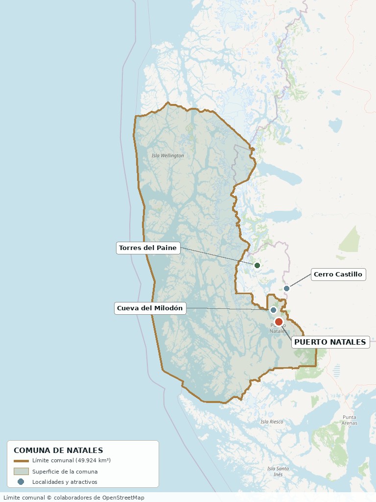
Commune boundary based on OpenStreetMap open data
§ 03 Location, Geography and Territory View
Where Puerto Natales is, what it is built on, and why its land matters.
3.1 Location
Puerto Natales lies 247 km northwest of Punta Arenas along Route 9, 112 km from Torres del Paine National Park and about 30 km from the Dorotea border crossing to Río Turbio, Argentina. It is the final port of call for the ferry that sails from Puerto Montt through the Patagonian channels, and the last town on Route 9 before the ice fields. Reference coordinates: 51°44'S, 72°30'W.
Downtown Puerto Natales facing the Señoret Channel · 51°44'S, 72°30'W
3.2 Terrain and setting
The town sits on a low terrace on the edge of the Señoret Channel, an arm of the sea that connects southward with the Almirante Montt Gulf and northwestward with the Última Esperanza fjord. To the east rises the Dorotea range, which marks the border with Argentina; to the west and north, the land breaks up into peninsulas, islands and fjords all the way to the Southern Ice Field.
The commune combines three very different landscapes: the Patagonian steppe in the east, suited to sheep ranching; the mountains and ice fields to the west, covered by Bernardo O'Higgins National Park, the largest protected wilderness area in Chile; and the archipelago of fjords and channels, practically uninhabited and home to much of the salmon farming industry.
3.3 Hydrography and coastline
Main bodies of water in the commune5 rows
| Body of water | Role in the territory |
|---|---|
| Señoret Channel and Última Esperanza Sound | The town's waterfront; it has given its name to the province since Juan Ladrillero's expedition in 1557. It defines the seafront promenade, the port and all waterfront real estate development. |
| Almirante Montt Gulf | A large inland sea south of the Señoret Channel; it links the commune with the network of Patagonian channels and with the ferry route from Puerto Montt. |
| Eberhard Fjord and Puerto Bories | The area immediately north of the town, where the historic cold-storage plant was built. Today it concentrates the highest-end hotels and the most expensive waterfront land in the commune. |
| Natales and Rubens rivers | Watercourses that feed the sound; the Rubens, to the south, structures an area of estancias and recent parcel subdivisions. |
| Laguna Sofía | About 30 km from town, next to the Cueva del Milodón. It is the focus of rural parcel (parcela de agrado) subdivisions with lake views and lakefront. |
3.4 Soils and land-use capability
The soils of the Magallanes steppe are thin, low in organic matter and exposed to constant wind that severely limits farming. The territory's historic vocation is extensive sheep ranching: it is measured in hectares per sheep, not tonnes per hectare.
- Advantage: vast areas available at a comparatively low price per hectare, with a ranching vocation established over more than a century.
- Limitation: crop farming is marginal; wind and the short growing season make greenhouses necessary for any vegetable production.
- Risk: a large part of the commune lies within state-protected wilderness areas, where there is no land market.
- Real estate implication: here the value of land almost never comes from its agricultural productivity but from three different things — view, access and proximity to the tourist route. It is a market for landscape, not for yield.
§ 04 Climate and Seasonality View
Contrary to the Patagonia of popular imagination, it rains little in Puerto Natales. What never stops is the wind.
Puerto Natales has a subpolar oceanic climate (Cfc in the Köppen classification), with cool, cloudy summers, cold winters and persistent wind twelve months a year. The average annual temperature is around 6.8 °C and the difference between the warmest and coldest months is only about 10 °C: the sea moderates the extremes but keeps temperatures low all year.
Reference climate parameters10 rows
| Parameter | Typical value | Comment |
|---|---|---|
| Mean annual temperature | ≈6.8 °C | Very stable from year to year |
| January average (summer) | ≈11 °C | Highs of 15-16 °C; above 20 °C is exceptional |
| July average (winter) | ≈1.7 °C | Average lows around −3 °C |
| Annual precipitation | ≈350 – 500 mm | Low for the latitude; sources differ (see section 22) |
| Rainfall distribution | Spread throughout the year | Peak in autumn; no marked dry or wet season |
| Wind | Constant, from the west | The dominant climate feature; strong gusts in spring and summer |
| Snow | Frequent in winter | July has the most snow days in town |
| Relative humidity | ≈73 % – 85 % | Highest in June, lowest in November |
| Daylight (December) | ≈16 h 36 min | Southern summers greatly lengthen the day |
| Daylight (June) | ≈7 h | The winter flip side of the same phenomenon |
The curve is surprising: Puerto Natales gets little rain, spread evenly, without the marked wet season of the rainy south. What defines the climate here is not water but wind and temperature range — the thermometer drops ten degrees between January and July, and the wind blows hard twelve months a year.
The most significant medium-term phenomenon is not drought but the glacial retreat of the Southern Ice Field, which is changing the landscape that sustains the commune's main industry and altering the flow of the rivers that empty into the sound.
§ 05 History: A Century Between the Cold-Storage Plant and the Park View
Puerto Natales is a working-class town founded by a company, which rebelled against it, and which a century later makes its living by showing off the landscape that surrounded it.
-
Pre-1557
Kawésqar and Aónikenk
The Última Esperanza Sound is inhabited by Kawésqar groups, canoe navigators of the channels, and traveled by Aónikenk (Tehuelche) bands across the steppe. The place name Paine comes from the Aonikenk language and means 'blue'.
-
1557
Juan Ladrillero and the last hope
The navigator Juan Ladrillero explores the fjord in search of the western exit of the Strait of Magellan. He names it Última Esperanza (Last Hope) because it was his last hope of finding the passage. He does not find it, but the name stays.
-
1893
The Sociedad Explotadora de Tierra del Fuego is born
The company that would dominate southern Patagonia is founded, tied to the interests of José Nogueira, Mauricio Braun, José Menéndez and British capital. It would eventually operate more than a million hectares.
-
1905
The Explotadora takes over Última Esperanza
The SETF acquires some 350,000 hectares in the province, becoming owner of nearly ninety percent of the territory's ranch land, with half a million sheep, after evicting settlers already established there. That same year the German settler Rodolfo Stubenrauch sets up a tallow works at Bories.
-
1911
Founding of Puerto Natales
On May 31, by Decree No. 832 of President Ramón Barros Luco, the settlement of Puerto Natales is officially founded at the mouth of the Natales River. That same year the Federación Obrera de Magallanes (Magallanes Workers' Federation) is founded in Punta Arenas; it would grow to 6,000 members.
-
1906–1915
The Bories Cold-Storage Plant
Five kilometers from town, the Sociedad Explotadora builds the largest cold-storage complex in the Magallanes region: slaughterhouse, freezing plant, tallow works, meat extract plant, tannery, wool washing, brickworks, sawmill, its own steamships and a narrow-gauge railway to Puerto Natales. Capacity to process 300,000 animals a year.
-
1910–1920
The migration from Chiloé
To staff the plant and the estancias, the company hires workers directly on the Isla Grande de Chiloé. Thousands of Chilotes cross the country by ship and settle in Natales, giving the town a working-class character and a cultural identity that endures to this day.
-
1916
The Bories railway
The railway line between Puerto Bories and Puerto Natales, built by the SETF to move workers and freight, enters service.
-
1919
The January workers' uprising
On January 20 the workers of the cold-storage plants go on strike, demanding an eight-hour workday and lower prices for basic goods. Between January 23 and 25 the conflict escalates into an armed clash with the police and company personnel, leaving several dead. The ensuing crackdown results in 27 detainees, including five minors, in a trial that drags on for years. It is remembered locally as 'the Puerto Natales Commune'.
-
1920–1940
Wool crisis and stagnation
Falling international wool prices and Argentine protectionist policies usher in a long period of economic stagnation throughout the province.
-
1959
Creation of Torres del Paine National Park
On May 13 the park is established that will, over time, become the commune's main economic engine. Today it covers 181,414 hectares.
-
1990
Closure of the Bories Cold-Storage Plant
After nearly sixty years of operation, industrial activity at the complex comes to an end. The site is declared a National Monument and years later converted into a hotel and museum, with its early 20th-century machinery preserved.
-
2000–2019
The turn to tourism
Torres del Paine establishes itself as a world-class destination and Puerto Natales is transformed from a ranching town into an international base camp. In 2019 the park receives 304,947 visits, a record at the time.
-
2020–2021
The pandemic shutdown
The complete closure of protected wilderness areas leaves the town without its main source of income and exposes the extent of its dependence on tourism.
-
2024
All-time record and demographic leap
The park surpasses all previous records with 367,426 visits, 66% more than in 2023. The 2024 Census confirms that the commune grew 12.5% since 2017, while the Magallanes Region remained stagnant at 0.0%.
§ 06 Cultural Identity and Indigenous Peoples View
A Chilote town built on Kawésqar and Aónikenk land, with the highest share of foreign-born residents in this series.
According to the Social Household Registry (Registro Social de Hogares) of March 2025, 21.3% of the population of Natales identifies as belonging to an Indigenous people, above the regional average (20.6%) and well above the national average (9.2%). Unlike the rainy south, where most people identify as Mapuche-Huilliche, here the Indigenous substrate corresponds to the Kawésqar — navigators of the channels — and the Aónikenk or Tehuelche of the steppe.
The other distinctive figure concerns migration: 9.7% of the population was born abroad, above the national average (8.7%) and well above the regional average (6.6%). It is the commune in this series with the largest foreign-born population, consistent with a tourism-services economy that demands seasonal labor.
The cultural layers of Puerto Natales4 rows
| Tier | Visible traces today |
|---|---|
| Kawésqar and Aónikenk | Place names (Paine, 'blue' in Aonikenk); archaeological sites such as the Cueva del Milodón; a recognized Kawésqar presence in the region and communities tied to the channels. These peoples' occupation predates any European settlement by millennia. |
| Chilote | The town's dominant demographic layer: thousands of workers brought from Chiloé between 1910 and 1930 for the cold-storage plant and the estancias. From them come the surnames, the seafood-and-potato cuisine, the curanto and a culture of wage labor and unionism. |
| European estancia heritage | Croatians, English, Germans and Spaniards linked to the Sociedad Explotadora and to commerce: the Braun, Menéndez and Stubenrauch families. They left behind the architecture of Puerto Bories, the estancias and the land-ownership structure that still shapes the rural territory. |
| Working-class and union heritage | The 1919 uprising is not a museum piece: it is a living element of identity, with commemorations, publications and historical walking routes. Puerto Natales sees itself as a town of workers. |
§ 07 Key Demographic Data View
7.1 Population and growth
Demographic indicators compared9 rows
| Indicator | Natales Commune | Magallanes Region | Country |
|---|---|---|---|
| Population, 2017 Census | 21,477 | 166,533 | 17,574,003 |
| Population, 2024 Census | 24,152 | 166,537 | 18,480,432 |
| Intercensal change | 12.5 % | 0.0 % | 5.2 % |
| Commune area | 49,924.1 km² | — | — |
| Population density (2024) | ≈0.5 inhab./km² | — | — |
| Foreign-born population | 9.7 % | 6.6 % | 8.7 % |
| Sex ratio 2024 | 99.8 | 98.1 | 94.3 |
| Demographic Dependency Ratio (IDD) 2024 | 45.8 | 45.4 | 46.5 |
| Elderly Index (IAM) 2024 | 84.1 | 87.1 | 79.0 |
7.2 Age structure (2024 Census)
Population distribution by age group5 rows
| Age group | 2017 Census | 2024 Census | % Commune 2024 |
|---|---|---|---|
| 0 to 14 years | 4,077 | 4,124 | 17.1 % |
| 15 to 29 years | 4,584 | 4,653 | 19.3 % |
| 30 to 44 years | 4,984 | 6,178 | 25.6 % |
| 45 to 64 years | 5,074 | 5,730 | 23.7 % |
| 65 years and over | 2,758 | 3,467 | 14.4 % |
The contrast with the other communes in this series is stark. While Puerto Octay is losing population and Osorno is growing below the national average, Natales is growing 12.5% in a regional context of zero growth. The increase comes not from births but from the arrival of young adults: the 30-to-44 age group added almost 1,200 people and became the largest in the commune.
The sex ratio fell from 104.8 to 99.8 between censuses; in other words, the town has balanced out: from a historically male settlement tied to estancias and cold-storage plants to a population of even composition. Aging does exist — the Elderly Index rose from 67.6 to 84.1 — but it remains below the regional average (87.1).
§ 08 Economic and Socioeconomic Data View
8.1 Poverty and social indicators (CASEN and Social Household Registry)
Comparative social indicators7 rows
| Indicator | Natales Commune | Magallanes Region | Country |
|---|---|---|---|
| Income poverty, Casen 2022 | 3.1 % | 3.4 % | 6.5 % |
| Multidimensional poverty, Casen 2017 | 14.1 % | 10.5 % | 20.3 % |
| Multidimensional poverty, Casen 2022 | 4.6 % | 6.9 % | 16.9 % |
| People in households lacking basic services (Mar. 2025) | 5.4 % | 6.8 % | 13.1 % |
| Overcrowded households (Mar. 2025) | 6.0 % | 5.2 % | 8.1 % |
| Indigenous population (RSH, Mar. 2025) | 21.3 % | 20.6 % | 9.2 % |
| Foreign population (RSH, Mar. 2025) | 7.7 % | 5.2 % | 6.7 % |
Social indicators in Natales are notably better than national ones and, in several cases, than regional ones. The most striking figure is the drop in multidimensional poverty from 14.1% to 4.6% between 2017 and 2022: a two-thirds reduction in five years, placing the commune at less than a third of the national average (16.9%). This is consistent with the expansion of tourism employment documented in section 9.
8.2 Economic activity (SII) and municipal finances (SINIM)
Business structure and municipal finances13 rows
| Economic indicator (SII / SINIM) | Value |
|---|---|
| Number of active businesses, commune (2023) | 3,192 |
| · Micro-enterprises | 2,123 |
| · Small companies | 491 |
| · Medium-sized companies | 54 |
| · Large companies | 17 |
| Reported salaried employees (2023) | 10,385 |
| Sector with the most workers (2023) | Accommodation and food services — 2,824 workers |
| Sector with the most businesses (2023) | Wholesale and retail trade — 817 businesses |
| Other relevant sectors | Accommodation and food (448 businesses); transport and storage (388); agriculture and livestock (318); manufacturing (245) |
| Share of the Municipal Common Fund in total revenue, 2024 | 25.6 % |
| Permanent own-source revenue (IPP) as a share of total revenue, 2024 | 30.0 % |
| Revenue from aquaculture licenses (Law 20,033), 2024 | $622,138 (thousands of $) |
| Total municipal revenue received, 2024 | $17,856,958 (thousands of $) |
The employment structure reveals the commune's transformation: accommodation and food services is the sector that employs the most workers (2,824 in 2023), ahead of trade (1,976) and agriculture and livestock (1,719). The sector grew from 1,756 workers in 2021 to 2,824 in 2023, a 61% increase in two years. The cold-storage town is today, statistically, a town of hotels and restaurants.
In municipal finances, one item stands out that no other commune in this series records: aquaculture licenses contribute more than $622 million a year, about 12% of the municipality's permanent own-source revenue. It is the budgetary reflection of the salmon farming established in the commune's channels.
§ 09 The Economic Engine: Torres del Paine and the Channels View
An economy that in twenty years went from sheep to trekking, and that today rests on two activities that barely existed a generation ago.
9.1 Tourism: 400,000 visitors a year pass through here
Torres del Paine National Park, 112 km from town, is the leading tourist attraction of the Magallanes Region and one of the most renowned natural destinations in the world. Puerto Natales is its essential base camp: the town concentrates the lodging, logistics, gear rental, transport and food services for virtually all of its visitors.
Visits to Torres del Paine National Park (CONAF)5 rows
| Year | Recorded visits | Remarks |
|---|---|---|
| 2019 | 304,947 | Pre-pandemic record |
| 2022 | 140,458 | Recovery after the health-related closure |
| 2023 | 220,912 | +57 % compared with 2022 |
| 2024 | 367,426 | +66 % compared with 2023; all-time high |
| 2025 | 366,642 | Official CONAF figure; the hotel industry estimates close to 415,000 |
The protected wilderness areas of Magallanes as a whole received 591,340 visits in 2024, 40% more than the previous year, and Torres del Paine accounted for 62% of that total. January and December are the busiest months, with more than 60,000 visits each. According to the hotel industry association, between 73% and 76% of visitors are foreigners.
One significant change in recent years is reduced seasonality: LATAM's decision to maintain regular winter flights to Puerto Natales boosted visits in June and July, traditionally dead months. It is the factor that does most to free the local economy from depending on just four months a year.
9.2 Salmon farming: the industry you don't see
In the fjords and channels of the commune's western sector operates a salmon farming industry that does not appear in the urban landscape but does show up in the municipal accounts: aquaculture licenses contributed $622 million to the 2024 budget, an amount stable since 2022 and far higher than mining licenses ($11 million). It is the municipality's second-largest source of permanent own-source revenue after business licenses.
The activity generates industrial and port employment that offsets the strong seasonality of tourism, but it also creates friction with the tourism model: many of the concessions are located in fjords that are part of the very landscape that attracts visitors.
9.3 Sheep ranching: the historic foundation
Agriculture, livestock and fishing account for 318 businesses and 1,719 workers in the commune, a figure that has grown from 1,425 in 2021. Extensive sheep ranching still occupies most of the productive land on the steppe, on very large estancias inherited from the ownership structure established by the Sociedad Explotadora more than a century ago.
9.4 Other pillars
- Trade: 817 businesses, the most numerous sector; it supplies the town and the tourist flow.
- Transport and storage: 388 businesses and 1,056 workers; includes passenger transfers to the park, the border crossing and port logistics.
- Port and sea link: the final terminal of the ferry from Puerto Montt through the Patagonian channels, a journey that is a tourism product in itself.
- Public services: as provincial capital, the commune concentrates government administration for the entire Última Esperanza territory.
§ 10 Real Estate Market View
10.1 A market under pressure
Puerto Natales is going through the most intense real estate cycle in its history. The regional press has described it as Patagonia's new 'golden ground': downtown properties with large built areas are selling for over one billion pesos, values comparable to those of international markets. The cause is an unusual combination: a population growing 12.5%, some 400,000 visitors a year, a salmon farming industry that needs housing, and an urban boundary governed by a Communal Zoning Plan (PRC) from the late 1980s.
10.2 Price by property type (indicative, 2026)
Indicative price ranges by property type8 rows
| Property type | Indicative range | Notes |
|---|---|---|
| Residential house (70–150 m²) | $160 – $300 million | Established areas of town; 2 to 4 bedrooms |
| Apartment | From UF 5,200 | Limited supply; new-build product geared to investment and rentals |
| Downtown house or house with tourism potential | $500 – $1,000 million+ | 500 m² built in the central area; traded as tourism assets, not as homes |
| Urban lot | Highly variable depending on frontage and tax roll | Serviced urban land is the scarcest asset in the market |
| Half-hectare rural parcel (outskirts) | $25 – $70 million | Dorotea, Camino 2 and 3, Route 9 areas |
| Rural parcel with a view or lakefront | UF 1,670 – UF 7,065 | Laguna Sofía, Puerto Bories, Península Antonio Varas |
| Operating hotel or hostel | $950 million – $1,200 million | Turnkey asset; the most liquid segment for investment |
| Farms (fundos) and large land lots | USD 4,000,000 for 3,259 ha | Estancia scale; appraisal per hectare far below that of the rainy south |
10.3 What drives prices in Puerto Natales
Value drivers in this market, ranked by impact7 rows
| Factor | Price impact | How to check it here |
|---|---|---|
| Suitability for tourism use (hostel, hotel, serviced apartments) | Critical | Certificate of Prior Information (Certificado de Informaciones Previas) from the DOM: which uses the current PRC zone allows |
| View of the sound, the fjord or the Paine massif | Very high | Check on site and find out whether neighboring properties could build in front |
| Being inside the urban boundary | Very high | Serviced urban land is scarce; an adjacent rural property is worth a fraction |
| Direct access to Route 9 | High | It is the main road to Torres del Paine and the airport; it determines customer flow |
| Availability of electricity and water | High | Remote subdivisions have no grid: check whether the project includes a well with registered DGA water rights and on-site power generation |
| Individual tax roll number (rol de avalúo) | Critical | Several subdivisions are sold with a 'pre-rol'; insist on actual individual registration |
| Maritime concessions in front of the property | Medium-high | Registry of aquaculture and port concessions with the Undersecretariat for the Armed Forces |
§ 11 Land-Use Planning in Natales View
What this commune's planning instrument specifically allows and prohibits.
The Natales Communal Zoning Plan (PRC) lists 1991 as its year of legal approval according to the SINIM 2024 report, although various local and press sources refer to the plan in force as the 1987 one. Either way, it is a set of regulations more than three decades old, designed for a ranching town with a fraction of today's population and none of the current tourism pressures. The regional press itself identifies the age of the zoning plan as one of the main challenges for the commune's urban development.
Planning instruments in force4 rows
| Instrument | Status | Implication |
|---|---|---|
| Communal Zoning Plan (PRC) | In force; legally approved in 1991 (SINIM 2024) | Sets the urban boundary, uses and densities using criteria from more than thirty years ago; it is the bottleneck of the land market |
| Subsequent sectional plans | 0 approved in 2023 and 2024 | There are no recent complementary instruments updating specific areas |
| PLADECO | Latest recorded version: 2017 | The communal development plan predates the current tourism and demographic cycle |
| PLADETUR Torres del Paine – Natales | Period 2021-2024 | A specific tourism development instrument, prepared with the Municipality of Natales |
Outside the urban boundary, the general regime for rural properties applies, and this is where the commune's peculiarity emerges: a very large portion of the territory has no land market at all, because it consists of state-protected wilderness areas — among them Bernardo O'Higgins National Park, the largest in Chile. The land that can actually be bought and sold is a small fraction of the commune's 49,924 km².
§ 12 Sectors and Localities View
Puerto Natales concentrates virtually the entire population of the commune in a compact urban area facing the Señoret Channel. The rest of the territory consists of low-density rural areas and small localities.
Sectors of the commune and their profile8 rows
| Sector | Features | Market profile |
|---|---|---|
| Downtown and waterfront | Civic and commercial core facing the Señoret Channel; concentrates hotels, restaurants and tourism services. | The most expensive segment; properties traded as tourism assets |
| Puerto Bories | 5 km to the north, on the Eberhard Fjord; site of the historic cold-storage plant turned hotel and museum, today the most upscale area. | Waterfront land and hotel projects; premium values |
| Established residential area | The town's residential neighborhoods, including the Gabriela Mistral corridor and the areas close to schools and services. | Houses of 70 to 150 m²; the residential market proper |
| Dorotea and Camino 2 / Camino 3 | Rural area right next to town, toward the border crossing; concentrates half-hectare parcel subdivisions with individual tax roll numbers. | Affordable rural parcels (parcelas de agrado); the highest-turnover segment |
| Laguna Sofía and Cueva del Milodón | About 30 km away, on the road north; a landscape of lake, caves and steppe. | Parcels with views and lakefront; a second-home and tourism product |
| Península Antonio Varas | Opposite the town, across the fjord; access by sea or by a road under development. | Large lots and land with native forest; low prices due to limited access |
| Cerro Castillo and the northern border area | Capital of the Torres del Paine commune, located about 60 km from Puerto Natales. | Ranch properties and roadside services |
| Western fjords and channels | Practically uninhabited territory, with protected areas and aquaculture concessions. | No real estate market; concessions, not ownership |
§ 13 Basic Services, Utilities and Digital Connectivity View
Urban coverage is better than the national average; a few kilometers from town, however, off-grid territory begins.
Only 5.4% of the population lives in households lacking basic services, far below the national average (13.1%) and even the regional one (6.8%). Within the urban area, coverage of drinking water, electricity and sanitation is well established.
Service providers and coverage7 rows
| Service | Status | Practical notes |
|---|---|---|
| Electricity | Established urban grid; isolated Magallanes power system | The region is not connected to the National Electric System: it runs on local generation. Remote subdivisions may have no grid, and the solution offered is solar panels and wind turbines |
| Gas | Natural gas from the Magallanes Region | Magallanes has its own natural gas and subsidized rates; it is the main source of heating and a cost advantage over the rest of the country |
| Urban drinking water | Full coverage in town | Outside the urban boundary, the solution is a private well with water rights registered with the DGA |
| Sewerage | Urban network | In rural areas, a septic tank authorized by the SEREMI of Health |
| Heating | Natural gas, firewood and electric | Heating costs are a central item in the household budget for much of the year |
| Internet and phone | Urban coverage; limited signal in rural areas and in the park | Coverage inside Torres del Paine is very sparse. On remote parcels, satellite internet is the usual alternative |
| Waste collection | Urban municipal service | Partial coverage across the vast rural area |
§ 14 Health View
A small network for a commune the size of a country, with the nearest high-complexity referral center 247 km away.
The commune has 9 health facilities (April 2025): one hospital, one CESFAM (family health center), one SAPU (primary emergency service), two rural health posts, two clinical laboratories, one private health center and one health office. The validated population enrolled in primary care reached 23,457 people in 2023, virtually the entire population of the commune.
Health network in the commune5 rows
| Facility | Type | Detail |
|---|---|---|
| Hospital de Puerto Natales | Public | The only hospital in Última Esperanza Province; it also handles emergencies for Torres del Paine visitors, including evacuations from the park |
| CESFAM | Primary care | One family health center, with an associated SAPU for emergencies |
| Rural Health Posts | Rural primary care | 2 posts for the commune's entire rural territory |
| Clinical laboratories | Diagnostic support | 2 facilities |
| Private health center | Private | 1 outpatient facility |
Comparative health indicators (2022)4 rows
| Indicator | Commune | Region | Country |
|---|---|---|---|
| Birth rate (per 1,000 inhab.) | 10.7 | 8.5 | 9.6 |
| Total fertility rate | 1.4 | 1.1 | 1.3 |
| Crude death rate (per 1,000 inhab.) | 7.1 | 6.9 | 6.9 |
| Infant mortality rate (per 1,000 live births) | 3.9 | 4.5 | 5.9 |
The birth rate in Natales (10.7 per thousand) is the highest of the three territorial levels and comfortably exceeds the regional rate (8.5), another sign of the arrival of young people. Infant mortality, at 3.9 per thousand, is significantly lower than the national average.
§ 15 Education View
15.1 School education
The commune has 16 schools (2024): 11 run by the Local Public Education Service (Servicio Local de Educación Pública) — following the transfer from municipal management completed in 2023 — and 5 state-subsidized private schools. There are no fee-paying private schools. Total enrollment is 4,673 students, virtually unchanged from 2022.
SIMCE 2024 results (preliminary)6 rows
| SIMCE 2024 test | Commune | Region | Country |
|---|---|---|---|
| 4° básico (Grade 4) — Reading | 269 | 277 | 278 |
| 4° básico (Grade 4) — Mathematics | 259 | 264 | 264 |
| 6° básico (Grade 6) — Reading | 241 | 249 | 249 |
| 6° básico (Grade 6) — Mathematics | 240 | 246 | 245 |
| 2° medio (Grade 10) — Reading | 238 | 277 | 249 |
| 2° medio (Grade 10) — Mathematics | 242 | — | 259 |
Results are below the regional and national averages at every level assessed, with the widest gap in 10th grade (2° medio): 238 points in reading versus 249 nationally and 277 regionally. It is the commune's weakest social indicator and contrasts with its performance on poverty and basic services.
15.2 Higher education
Puerto Natales has no university campus of its own. The regional reference is the Universidad de Magallanes, headquartered in Punta Arenas (247 km), along with the technical and professional programs available in that city. Enrollment in technical-vocational secondary education in the commune (422 students in 2024) is the main channel for training the local workforce for the tourism and services sectors.
§ 16 Torres del Paine and the Natural Setting View
Few communes in Chile have such a concentration of protected natural heritage within their boundaries or close at hand. The Natales territory includes or provides access to two major national parks, natural monuments, glaciers and the Southern Ice Field. Torres del Paine National Park, although located outside the commune, is its main associated tourist destination, and Puerto Natales is its main gateway and service town.
Natural attractions by distance6 rows
| Attraction | Approx. distance | Activities |
|---|---|---|
| Torres del Paine National Park | 112 km | W Trek and O Circuit, mountaineering, boat trips to Grey Glacier, wildlife; 181,414 hectares |
| Cueva del Milodón Natural Monument | ≈24 km | Paleontological and archaeological site; remains of the mylodon and evidence of early human occupation |
| Bernardo O'Higgins National Park | Access by sea | The largest protected wilderness area in Chile; Serrano and Balmaceda glaciers |
| Laguna Sofía | ≈30 km | Climbing, kayaking, horseback riding and lakefront rural parcels |
| Última Esperanza Sound and fjords | From town | Boat trips, marine wildlife watching, fishing |
| Southern Ice Field (Campos de Hielo Sur) | Western sector of the commune | Highly demanding mountain expeditions |
Puerto Natales, Cueva del Milodón, Cerro Castillo and the access to Torres del Paine
§ 17 Connectivity and Transportation View
17.1 Road network
Route 9 is the backbone of the commune: it connects Puerto Natales with Punta Arenas to the south and with Cerro Castillo and Torres del Paine to the north. There is no continuous overland connection with the rest of Chile: to arrive by land from the north of the country you must cross Argentine territory.
Routes and distances7 rows
| Route / destination | Distance and details |
|---|---|
| Route 9 | Main artery; links the commune with Punta Arenas and with the access to Torres del Paine |
| Punta Arenas | 247 km to the southeast, ≈3 hours; regional capital and high-complexity referral center |
| Torres del Paine National Park | 112 km to the north |
| Dorotea border crossing | ≈16 km; connection with Río Turbio, Argentina |
| Río Don Guillermo crossing (Cerro Castillo) | ≈65 km; alternative route to El Calafate, Argentina |
| El Calafate (Argentina) | ≈270 km; binational circuit with Los Glaciares National Park |
| Santiago | No continuous overland connection through Chilean territory |
Puerto Natales on the Route 9 corridor toward Punta Arenas, Magallanes Region
17.2 Airport
Teniente Julio Gallardo Aerodrome, about 7 km from town, receives seasonal commercial flights and, for several seasons now, regular winter services as well. LATAM's decision to keep winter flights has been cited by the tourism industry as one of the factors that has done most to reduce the seasonality of the local economy. The best-connected airport remains Presidente Carlos Ibáñez del Campo in Punta Arenas.
17.3 Land and sea transport
- Intercity buses: regular services to Punta Arenas and, in season, direct transport to Torres del Paine National Park.
- International connections: buses to Río Turbio, El Calafate and Río Gallegos, Argentina, via the Dorotea and Río Don Guillermo crossings.
- Channels ferry: Puerto Natales is the final port on the sea route that sails from Puerto Montt through the Patagonian channels, a multi-day journey that is a tourism product in itself.
- Local boat trips: vessels to the Serrano Glacier, Bernardo O'Higgins National Park and Península Antonio Varas.
§ 18 Tourism: Development, Attractions and Things to Do View
18.1 Tourism development
Tourism has gone from a complement to the commune's main employer: 448 accommodation and food-service businesses employ 2,824 people, more than any other sector. The commune has a PLADETUR Torres del Paine – Natales (tourism development plan) for the 2021-2024 period, prepared with the Municipality of Natales.
The sector has clearly set out its own challenges: extending the low season, strengthening the training of local human capital, bringing infrastructure up to the level of demand and — insistently — solving the lack of reliable statistics. The Última Esperanza Chamber of Tourism has proposed creating a Regional Tourism Observatory to consolidate data from municipalities, INE, SERNATUR, Customs, PDI and CONAF.
18.2 Attractions in and around town
- Waterfront and wind monument: the promenade along the Señoret Channel, with views of Cerro Benítez and Cerro Dorotea and of the snow-capped range across the fjord.
- Puerto Bories and the Cold-Storage Plant: a National Monument 5 km from town; it preserves early 20th-century machinery and houses a museum on the industrial and ranching history of Patagonia, as well as high-end hotel accommodation.
- Municipal Historical Museum: collections on the Kawésqar and Aónikenk peoples, colonization, the cold-storage industry and the commune's labor history.
- Cueva del Milodón Natural Monument: 24 km away; a huge cave where remains of the mylodon, an extinct Pleistocene mammal, were found along with evidence of early human occupation.
- Historical route of the 1919 uprising: a tour of the sites of the events of January 1919, from the Bories cold-storage plant to the buildings of downtown Natales.
- Cerro Dorotea Lookout: a short climb with panoramic views over the town, the Última Esperanza Sound and the steppe.
- Historic Pier: The old pier of Puerto Natales, facing the Señoret Channel, preserves part of the town's port heritage and offers a prime spot to take in the coastal scenery and the sunsets.
- Iglesia Jesús Nazareno: A historic Catholic church in Puerto Natales, linked to the town's religious tradition and urban identity. Its architecture and location make it a point of interest on any walk through the historic center.
- Monumento de la Mano (Hand Monument): A sculpture on the Puerto Natales waterfront depicting a hand emerging from the ground. It is one of the town's contemporary urban landmarks and a popular spot for visits and photos.
- La Tehuelche: A space dedicated to local crafts and artistic production, with works tied to Patagonian identity and the region's traditions.
18.3 Excursions from town
- Torres del Paine, full-day trip or multi-day trek: the excursion that defines the destination; the W (4-5 days) and O (7-9 days) circuits, or a day visit from Natales.
- Boat trip to the Balmaceda and Serrano glaciers: a full day across the Última Esperanza Sound to Bernardo O'Higgins National Park.
- Laguna Sofía: climbing, kayaking and horseback riding 30 km from town.
- Crossing to El Calafate and Perito Moreno: a one- or two-day binational circuit to Argentina's Los Glaciares National Park.
- Patagonian estancias: visits to working ranches with sheep shearing, spit-roasted lamb (asado al palo) and sheep herding.
18.4 Food and dining
Natales cuisine combines the Chilote heritage of its founders with the seafood of the southern seas and Magallanes livestock.
- Spit-roasted Magallanes lamb (cordero al palo): the region's signature dish, slow-roasted over an open fire.
- Centolla and centollón (southern king crab): crustaceans from the southern channels, in a regulated season.
- Curanto and Chilote cuisine: a direct legacy of the migration that founded the town.
- Breweries and specialty coffee shops: a scene that has grown alongside international tourism; two coffee shops in the region have been recognized among the best in the country.
- Southern hake and seafood: landed locally at the town's port.
18.5 Calendar and seasonality
The tourism year in Puerto Natales6 rows
| Period | Status | Character |
|---|---|---|
| December – February | High season | January and December exceed 60,000 visits a month to the park; hotel capacity stretched to the limit |
| March – April | Shoulder season | Patagonian autumn, colors and less wind; highly prized by photographers |
| May – August | Growing low season | Regular winter flights have boosted visitor numbers in June and July |
| September – November | Season opening | Windy spring; routes and services start up again |
| May 31 | City anniversary | Commemoration of the 1911 founding |
| January 23 | Commemoration of the 1919 uprising | Historical and labor memory events |
§ 19 Daily Life, Safety and Practical Information View
What anyone planning to live in Puerto Natales — not just visit — needs to know.
19.1 Safety
Reported crime rates per 100,000 inhabitants2 rows
| Indicator | Commune 2024 | Region 2024 | Country 2024 |
|---|---|---|---|
| Violent crime | 1,867.6 | 1,360.0 | 2,222.7 |
| Domestic violence | 783.6 | 551.8 | 601.0 |
The rate of reported violent crime in Natales (1,867.6) is below the national average (2,222.7) but clearly above the regional one (1,360.0). For domestic violence, by contrast, the commune exceeds both the regional and national averages, with 783.6 reports per 100,000 inhabitants. It is an indicator worth keeping in mind, and one the municipality itself has addressed in its social programs.
19.2 Participation and civic life
In the final electoral roll of October 2024, the commune had 23,806 registered voters and a turnout of 70.2%, below the regional (75.4%) and national (84.9%) averages. Foreign voters make up 4.7% of the roll, above the regional average (3.1%).
19.3 Where to handle paperwork
Offices based in Puerto Natales5 rows
| Office | Status | Remarks |
|---|---|---|
| Ilustre Municipalidad de Natales (Municipality of Natales) | Office in town | Municipal Works Department: Certificate of Prior Information and building permits |
| Real Estate Registrar (Conservador de Bienes Raíces) | Office in town | As provincial capital, Puerto Natales has its own Real Estate Registrar (Conservador), an advantage over communes that must process paperwork in another city |
| Civil and Criminal Guarantee Court (Juzgado de Letras y Garantía) | Office in town | Located in a building linked to the history of 1919 |
| Hospital de Puerto Natales | Office in town | The only hospital in the province |
| Regional services (SEREMI, regional SII) | Punta Arenas | Regional-level procedures require a ≈3-hour trip or online processing |
19.4 Cost of living and practical considerations
- Regional natural gas at a preferential rate makes heating substantially cheaper than in communes that rely on firewood or liquefied gas.
- Imported consumer goods and food tend to be more expensive because of the logistics cost of supplying the far south, partly offset by extreme-zone tax exemptions.
- Housing is relatively expensive: downtown values have caught up with those of metropolitan markets, without local incomes keeping pace.
- There are extreme-zone subsidies and tax exemptions, including support for renewable energy solutions on off-grid properties.
- Seasonal employment is a central factor: many tourism jobs are seasonal, with implications for household income flows.
§ 20 Territorial Analysis: Strengths, Challenges and Opportunities View
An honest reading of the territory. A sound investment decision also requires knowing what doesn't work.
- Population growth of 12.5% between censuses, in a region that grew 0.0%: it is the only commune in this series gaining population significantly.
- Multidimensional poverty of 4.6%, less than a third of the national average and down from 14.1% in 2017.
- The essential gateway to Torres del Paine, with some 400,000 visitors a year, 73-76% of them foreigners.
- Tourism established as the main employer: 2,824 workers in accommodation and food services, with 61% growth between 2021 and 2023.
- Diversified municipal revenue, with aquaculture licenses worth more than $622 million a year.
- Regional natural gas at a preferential rate, a cost-of-living advantage over the rest of the country.
- Provincial capital with its own Real Estate Registrar (Conservador de Bienes Raíces), hospital and court.
- A Communal Zoning Plan (PRC) from the late 1980s — with legal approval recorded in 1991 — for a town that has completely changed in vocation and size.
- Structural shortage of serviced urban land, with prices already reaching metropolitan-market levels.
- SIMCE results below the regional and national averages at every level assessed, with a very wide gap in 10th grade (2° medio).
- No local higher education, in a commune whose main sector acknowledges the lack of trained human capital as a bottleneck.
- Domestic violence rate (783.6) above the regional and national averages.
- Voter turnout of 70.2%, the lowest of the three territorial levels.
- Extreme dependence on a single activity: the 2020-2021 pandemic shutdown showed what happens when the tourist flow stops.
- Lack of reliable tourism statistics, with documented discrepancies of tens of thousands of visitors between official reports.
- A 247 km distance to the high-complexity referral center in Punta Arenas.
- Updating the zoning plan: any expansion of the urban boundary would release land in a market currently choked by supply.
- Seasonality already easing: regular winter flights have boosted visitor numbers in June and July, extending the income season.
- Special-interest tourism anchored in industrial heritage and labor memory — the Bories cold-storage plant, the 1919 route — as an alternative to mass trekking.
- A binational circuit with El Calafate and Los Glaciares National Park, 270 km away via operating border crossings.
- Sustained demand for lodging and services: an operating tourism asset is today the most liquid segment of the local market.
- Local technical training linked to tourism, in a territory where the industry itself has declared the need.
- Concentration of risk in Torres del Paine: any access restriction, severe weather event or park closure immediately hits the entire local economy. In 2026 CONAF already ordered an early closure of the O Circuit due to weather conditions.
- Tension between salmon farming and tourism over the use of the fjords that make up the destination's landscape.
- Glacial retreat in the Southern Ice Field, which is altering the long-term landscape asset.
- Housing prices decoupled from local incomes, with a risk of displacing the resident population.
- Infrastructure overload in high season, as noted by the hotel industry itself.
Puerto Natales: Territory, Connectivity and Opportunities
Puerto Natales is today one of the most dynamic markets in Chilean Patagonia: a commune that is growing while its region stagnates, with almost 400,000 visitors a year, an aquaculture industry that contributes to the municipal budget and scarce urban land that has pushed values to unprecedented levels. It is also a territory of stark contrasts — 49,924 km² and 24,152 inhabitants, metropolitan prices and far-south incomes — where understanding the details matters more than anywhere else.
At Produncan Lands we know this territory and its opportunities. Our work is to connect properties with people looking to invest, live and develop new projects in southern Chile, offering our experience, local knowledge and commercial reach.
We invite you to explore our properties in Puerto Natales, Patagonia and throughout southern Chile, and to entrust Produncan Lands with the sale of your property.
View properties at Produncan Lands§ 22 Sources and Methodology Note View
22.1 Sources consulted
Documents and sources used12 rows
| Scope | Document and year |
|---|---|
| Population and demographics | 2025 Communal Statistical Report for Natales, BCN, with data from the 2017 and 2024 Censuses (INE) |
| Social indicators | CASEN 2017 and 2022 (MDS); Social Household Registry, March 2025 (ADIS and BIDAT) |
| Economic activity | SII Business Statistics 2021-2023, via the BCN 2025 Communal Report |
| Municipal finances and planning | SINIM 2022-2024 (SUBDERE), including the year of legal approval of the Communal Zoning Plan |
| Education | MINEDUC Research Center 2022-2024; Education Quality Agency, preliminary SIMCE 2024 (22-04-2025) |
| Health | DEIS, MINSAL (facilities as of 29-04-2025); FONASA Open Data 2023 |
| Safety | Center for Crime Studies and Analysis (CEAD), Undersecretariat for Crime Prevention, 2022-2024 |
| Electoral participation | Final electoral roll, October 2024, SERVEL |
| Tourism and visitor numbers | CONAF Magallanes (2023, 2024, 2025); Torres del Paine Hotels and Tourism Services Association (HYST); PLADETUR Torres del Paine–Natales 2021-2024 |
| History | Memoria Chilena (National Library); Decree No. 832 of May 31, 1911; Ramón Arriagada, «La rebelión de los tirapiedras: Puerto Natales 1919» (Ediciones UMAG, 2010) |
| Climate | Weather Atlas and climate-data.org, 1991-2021 series |
| Real estate market | Portalinmobiliario, Yapo, Mercado Libre, Trovit, Mitula and Economicos.cl listing portals; regional press report on the local land market (May 2026), accessed August 2026 |
22.2 Methodology note and data currency
- Population data correspond to the 2024 Census as reported in the BCN 2025 Communal Report; they may be adjusted when INE publishes final figures.
- The available climate sources differ significantly on total precipitation in Puerto Natales: the records consulted range from just over 300 mm to nearly 500 mm a year. The monthly profile presented in section 4 is indicative and should be taken as an order of magnitude, not as a statistical record.
- The year of the Communal Zoning Plan is disputed: SINIM 2024 records 1991 as the year of legal approval, while regional press sources refer to the plan in force as the 1987 one. We recommend confirming it directly with the Municipal Works Department before any project.
- Visitor figures for Torres del Paine are the subject of public controversy: the hotel industry has documented discrepancies of tens of thousands of visitors between CONAF reports obtained under the Transparency Law, and maintains that the actual 2025 count exceeds 415,000 entries versus the official 366,642. The figures are presented with that caveat.
- It was not possible to verify with an official source the number of active aquaculture concessions or the direct employment generated by salmon farming in the commune; the analysis in section 9 relies on municipal revenue from aquaculture licenses, which is official data.
- Real estate price ranges are indicative as of 2026, built from current public listings and specialized press; they do not constitute an appraisal. Each property must be assessed individually.
- This document does not constitute legal or tax advice. Before any transaction, consult a lawyer and your tax advisor.
- Closing date of this edition: August 2026. We recommend reviewing the indicators in sections 7, 8, 9 and 10 annually.
Territorial reference document prepared by Produncan Lands. It combines official information (INE, BCN, SII, SINIM, MINEDUC, CONAF, MINSAL) with local market knowledge, so that anyone — resident, visitor, investor or buyer — can understand Puerto Natales in depth before making a decision.