Puerto OctayThe port that milks the lake
The Northern Basin of Llanquihue — German Heritage, Dairy and Volcanoes
THE PORT THAT LOOKS OUT ON TWO VOLCANOES
Puerto Octay was born from a name no one can fully explain: where Vicente Pérez Rosales wanted to honour a naval officer and christened the place Muñoz Gamero, the German settlers ended up saying Octay, and the territory kept that word of uncertain origin — fitting for a town founded twice, once by colonisation decree in 1852 and again as a commune in 1891, and one that grew up facing the water before the land.
This is the northern shore of Llanquihue, the lake that Puerto Varas and Frutillar see from the west and south, while Puerto Octay looks at it from the north, with the Osorno Volcano on one side and Puntiagudo peeking out on the other. Here steamers carried milk and passengers long before Route 5 existed, and that role as a port — a hinge between water and road — left its mark on the shingle-clad houses, on surnames such as Wulf, Niklitschek and Ochs, and on a town that today lives as much from the dairy cows of the plains as from those who arrive seeking a view of the volcano.
It is a temperate land of generous pasture: the same rain that soaks its 1,795 km² sustains a dairy basin that now competes head to head with the largest dairy districts in Chile, while remaining one of the least developed corners of the lakes circuit — the one that does not yet bear the tourist imprint of its neighbours, and which for that very reason still holds something they have already lost.
Version 1.0 · Expanded edition · August 2026
The Commune at a Glance
The key facts about Puerto Octay at a glance. Each figure is developed in the corresponding section.
Administrative identification and reference data13 rows
| Fact | Detail |
|---|---|
| Official name | Commune of Puerto Octay |
| Region / Province | Los Lagos Region / Osorno Province |
| Demonym | Octayino / Octayina |
| Civic center coordinates | 40°58'S — 72°54'W |
| Area | 1,795.7 km² |
| Elevation | ≈70 m above sea level in the urban area |
| Dialing code | +56 64 |
| Main towns | Puerto Octay (commune seat) and Las Cascadas (lakeside resort) |
| Time zone | UTC−4 (CLT) / UTC−3 in summer time (CLST) |
| Climate classification | Cfb — temperate oceanic, with no marked dry season |
| Commune anniversary | 22 December (created in 1891) |
| Mayor (2024-2028) | María Elena Ojeda Betancourt |
| Municipality | Municipality of Puerto Octay (Ilustre Municipalidad) · munipuertoctay.cl |
Overview
Puerto Octay is a commune in Osorno Province, Los Lagos Region, located on the northern shore of Lake Llanquihue. Founded as a settlement in 1852 as part of the German colonisation led by Bernardo Philippi and Vicente Pérez Rosales, and created as a commune on 22 December 1891, its historic centre — declared a Zona Típica (protected heritage zone) in 2010 — preserves one of the best-kept concentrations of colonial-settler architecture in southern Chile.
Unlike Osorno, which serves as the services capital for the whole province, Puerto Octay is an overwhelmingly rural commune: 66.7% of its population lives outside the urban area, spread across 1,795.7 km² — nearly twice the surface area of the commune of Osorno, yet with barely twenty per cent of its population. It is a low-density commune (≈4.9 inhab./km²) sustained by two activities that rarely coexist in equal measure: a dairy basin of national scale and an expanding lakeside tourism circuit.
The contrast with its neighbours on the Interlagos circuit is the key to understanding its position: Puerto Varas and Frutillar concentrate the hotels, tea houses and the bulk of tourism investment in the basin; Puerto Octay has the same landscape — Osorno Volcano, Puntiagudo Volcano, the waters of Llanquihue — with a fraction of the real estate development and, therefore, of the land price. It is the commune where the lakes circuit can still be bought before it has fully consolidated.
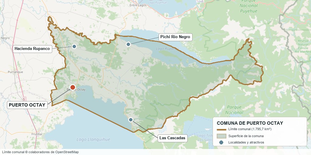
Commune boundary based on OpenStreetMap open data
§ 03 Location, Geography and Territory View
Where Puerto Octay is, what it is built on and why its soil matters.
3.1 Location
Puerto Octay lies 958 km south of Santiago via Route 5 South and Route U-55, 49 km from Osorno, 48 km from Puerto Varas and 64 km from Puerto Montt. It borders Puyehue and Osorno to the north, Río Negro and Purranque to the west, Frutillar to the southwest and Puerto Varas to the south and east. Reference coordinates of the civic centre: 40°58'S, 72°54'W.
Civic centre of Puerto Octay · 40°58'S, 72°54'W
3.2 Terrain and setting
The commune stretches west from the northern shore of Lake Llanquihue, covering part of the Central Valley and the foothills of the Coastal Range. The town of Puerto Octay sits on a raised terrace facing the lake, with direct views of Osorno Volcano (2,660 m) to the southeast and Puntiagudo Volcano to the east. The lakeside resort of Las Cascadas, on the same lake but further south, is the commune's second population centre and its tourist face.
3.3 Hydrography
Main bodies of water in the commune3 rows
| Watercourse | Role in the territory |
|---|---|
| Lago Llanquihue | The second-largest lake in Chile; it borders the entire eastern and southern edge of the commune. Fed by snowmelt from Osorno Volcano, it defines the siting of the town, Las Cascadas and all lakeshore parcel development. |
| Río Blanco and smaller streams | Watercourses that flow down from the Coastal Range towards the lake; relevant to water feasibility in the western rural sector of the commune. |
| Springs and aquifers of the Rupanco sector | Intake source for the rural drinking water system; its fragility has caused recurring supply outages (see section 13). |
3.4 Soils
The commune's soils are of recent volcanic origin (trumao soils), deep and with good moisture retention, similar to those that sustain the dairy basins of Osorno and Río Bueno. On them grows high-yield permanent pasture that needs no irrigation — the physical foundation of the commune's dairy industry.
- Advantage: deep trumao soils with excellent suitability for permanent pasture; forage production almost year-round without irrigation.
- Limitation: the natural acidity of trumao soils, which requires periodic liming to maintain pasture yields.
- Risk: areas of ñadi soil (a thin layer over an impermeable iron pan, or fierrillo) towards the west of the commune, with poor winter drainage and lower suitability for building.
- Real estate implication: a property with a lake view and one with genuine dairy potential may be only a few kilometres apart and follow completely different pricing logics; it is worth identifying which of the two uses prevails before valuing it.
§ 04 Climate and Seasonality View
The same rain that fills Lake Llanquihue sustains the pasture that feeds the country's second-largest dairy basin.
Puerto Octay has a rainy temperate oceanic climate (Cfb), with rainfall throughout the year concentrated in the cold half. The mean annual temperature is around 10.5 °C, with damp, cold winters and short, mild summers, helped by the moderating effect of Lake Llanquihue.
Reference climate parameters10 rows
| Parameter | Typical value | Comment |
|---|---|---|
| Mean annual temperature | ≈10.5 °C | Moderated by the lake's body of water |
| Mean maximum (January) | ≈20 °C | Extremes above 28 °C are uncommon |
| Mean minimum (July) | ≈4.3 °C | Frequent frosts on the plains, not on the lakeshore |
| Annual precipitation | ≈1,150 – 1,300 mm | Similar to Osorno's pattern, somewhat moderated by the lake |
| Wettest month | June | ≈176 mm |
| Driest month | January | ≈54 mm |
| Rainy days (August) | ≈20.6 days | Annual maximum |
| Relative humidity (June) | ≈88% | Lowest in January, ≈77% |
| Sunshine hours (January) | ≈9 h 36 min per day | Lowest in June, ≈3 h 42 min |
| Snow in the urban area | Occasional, does not settle | Lasting snow on the slopes of Osorno Volcano |
June and July bring more than three times the rainfall of January. It is the same pattern that sustains the permanent pasture of the Llanquihue dairy basin: here rain is not a drawback of the landscape, it is the raw material of the economy.
The medium-term risk is not drought — the commune stays humid all year round — but the fragility of the drinking-water intake and distribution infrastructure, which has caused recurring outages even in years of normal rainfall (see section 13).
§ 05 History: from Steamer Port to Circuit Commune View
Puerto Octay was born as a lake link before the road network that now surrounds it existed. That original role explains its layout and its architecture.
-
Pre-1852
Huilliche territory
The northern part of Llanquihue is inhabited by Huilliche communities, who remain present in the commune's rural territory to this day.
-
1852
Start of German colonisation
Bernardo Philippi and, after his death that same year, Vicente Pérez Rosales promote the settlement of German colonist families in the Llanquihue basin. The first inhabitants settle in the Playa Maitén area.
-
1852
Launch of 'La Fundadora'
On the lakeshore, in the area known as 'La Fábrica', the first vessel to sail Lake Llanquihue is built on the orders of Pérez Rosales, giving rise to the lake transport that would define the settlement's calling as a port.
-
1859
First documented mention of 'Octay'
The decree of 6 July 1859 that administratively divides the Llanquihue Colonisation Territory records the name 'Octay' for the first time, replacing the earlier name of Puerto Muñoz Gamero, given in honour of the naval explorer Benjamín Muñoz Gamero.
-
≈1860
Early commercial boom
A mill, a distillery and Cristino Ochs's general store are established, supplying settlers along the whole northern shore of the lake — the origin of the local saying 'donde Ochs hay' (roughly, 'if anyone has it, Ochs does').
-
1891
Creation of the commune
On 22 December, under the presidency of Jorge Montt, the commune of Puerto Octay is officially created, consolidating its role as a connecting port between Osorno and Puerto Montt, before the arrival of the railway and Route 5.
-
1912
Casa Izquierdo and elite summer holidays
The town's first grand summer house is built; it went on to host Chilean presidents and visitors from the European aristocracy, establishing Puerto Octay as a holiday destination for the Santiago elite in the early twentieth century.
-
1920–1950
Heyday and decline of lake transport
The steamers crossing Lake Llanquihue connect Puerto Octay with Puerto Varas and Puerto Montt. The arrival of Route 5 South and the railway, neither of which passes through the commune, gradually displaces its role as a transport hub, beginning a period of relative economic stagnation compared with its better-connected neighbours.
-
1986
Founding of the Museo El Colono
The Tourism Development Corporation and the Rotary Club of Puerto Octay create the museum that brings together the material heritage of German colonisation, today the commune's main cultural attraction.
-
1993
Creation of the Universidad de Los Lagos
With its main campus in Osorno, it becomes the nearest state higher-education institution for the commune, 49 km away.
-
2010
Declaration as a Zona Típica
The National Monuments Council declares the historic centre of Puerto Octay a 'Zona Típica', protecting more than 23 hectares of the original layout and its settler architecture along Independencia, Pedro Montt, La Esperanza, Germán Wulf and other central streets.
-
2019
First major drinking-water crisis
Hydrocarbon contamination at the intake leaves more than 700 homes in the historic sector without drinking water for 19 days, exposing the fragility of a network built in the 1960s.
-
2023
Declaration of the Lago Llanquihue ZOIT
SERNATUR declares the Lago Llanquihue Zone of Tourist Interest, bringing Puerto Octay together with Frutillar, Llanquihue and Puerto Varas under shared tourism governance and formally recognising its potential within the circuit.
-
2026
New water emergency episodes
Outages and contamination of the rural drinking-water supply in the Rupanco sector, together with episodes of low storage in the town's tanks due to summer overdemand, revive the debate over the need to modernise the commune's sanitation infrastructure.
§ 06 Cultural Identity and Indigenous Peoples View
Puerto Octay has one of the highest proportions of Indigenous population in the region, living side by side with the heritage of German colonisation.
According to the Social Household Registry of March 2025, 31.8% of Puerto Octay's population identifies as belonging to an Indigenous people, above the regional average (26.0%) and far above the national average (9.2%). The majority identify as Mapuche-Huilliche, a people present in the rural and coastal areas of the territory since before the colonisation of 1852.
The two cultural layers of Puerto Octay2 rows
| Tier | Visible traces today |
|---|---|
| Huilliche | Active communities in the rural sector, especially towards the west of the commune; local place names (Rupanco, Pichi Río Negro); cultural ties with neighbouring communities on the Osorno coast; the Puerto Octay Hospital runs intercultural health programmes focused on Williche childbirth and child-rearing. |
| German (colonisation since 1852) | The entire historic centre, declared a Zona Típica in 2010; surnames Wulf, Niklitschek, Ochs, Haase; shingle-clad architecture and steep roofs; the Museo El Colono; a cuisine of kuchen, strudel and smoked sausages; the Noche Octayina, a parade of illuminated boats with unmistakably Central European roots. |
The coexistence of both layers is visible in the same space: the town's colonial layout, with its church and shingle-clad houses, contrasts with a largely Huilliche rural territory that surrounds this urban core on almost every side. It is a commune where, unlike Osorno, the Indigenous share is not a background statistic but one of the most pronounced demographic traits in the entire region.
§ 07 Key Demographic Data View
7.1 Population and growth
Comparative demographic indicators10 rows
| Indicator | Puerto Octay commune | Los Lagos Region | Country |
|---|---|---|---|
| Population, 2017 Census | 8,999 | 828,708 | 17,574,003 |
| Population, 2024 Census | 8,865 | 890,284 | 18,480,432 |
| Intercensal change | −1.5% | 7.4% | 5.2% |
| Commune area | 1,795.7 km² | — | — |
| Population density (2024) | ≈4.9 inhab./km² | — | — |
| Rural population | ≈66.7% | — | — |
| Foreign-born population | 1.9% | 4.0% | 8.7% |
| Sex ratio 2024 | 103.9 | 96.5 | 94.3 |
| Demographic Dependency Ratio (IDD) 2024 | 50.2 | 45.3 | 46.5 |
| Elderly Index (IAM) 2024 | 100.1 | 75.8 | 79.0 |
7.2 Age structure (2024 Census)
Population distribution by age group5 rows
| Age group | Population 2024 | % Commune |
|---|---|---|
| 0 to 14 years | 1,480 | 16.7% |
| 15 to 29 years | 1,668 | 18.8% |
| 30 to 44 years | 1,742 | 19.7% |
| 45 to 64 years | 2,494 | 28.1% |
| 65 years and over | 1,481 | 16.7% |
Puerto Octay is the only commune in the regional comparison group with a declining population over the intercensal period (−1.5% versus +7.4% regionally and +5.2% nationally), and its Elderly Index (100.1) means there are already more older adults than children under 15, well above the regional (75.8) and national (79.0) averages. Together with the highest masculinity index of the three territorial levels (103.9), this is the demographic profile of a rural commune that loses working-age population to neighbouring urban centres.
With two-thirds of its population living in rural areas, Puerto Octay stands out even within its own province: while Osorno concentrates the vast majority of its inhabitants in the urban area, the reverse is true in Puerto Octay, where the commune seat is just one of several population centres scattered across 1,795.7 km².
§ 08 Economic and Socioeconomic Data View
8.1 Poverty and social indicators (CASEN and Social Household Registry)
Social indicators compared6 rows
| Indicator | Puerto Octay commune | Los Lagos Region | Country |
|---|---|---|---|
| Income poverty, Casen 2022 | 7.5% | 7.0% | 6.5% |
| Multidimensional poverty, Casen 2022 | 30.7% | 19.7% | 16.9% |
| People in households lacking basic services (Mar. 2025) | 41.7% | 23.1% | 13.1% |
| Overcrowded households (Mar. 2025) | 8.7% | 7.5% | 8.1% |
| Indigenous population (RSH, Mar. 2025) | 31.8% | 26.0% | 9.2% |
| Foreign population (RSH, Mar. 2025) | 0.9% | 2.3% | 6.7% |
Puerto Octay shows markedly worse social indicators than Osorno and the regional average: multidimensional poverty (30.7%) is almost double the national average, and 41.7% of the population lives in households lacking basic services — nearly four times the national average (13.1%) — a direct reflection of the commune's scattered rural settlement and the chronic fragility of its drinking-water network, documented in sections 5 and 13.
8.2 Economic activity (SII) and municipal finances (SINIM)
Business structure and municipal finances11 rows
| Economic indicator (SII / SINIM) | Value |
|---|---|
| Number of active businesses, commune (2023) | 736 |
| · Micro-enterprises | 438 |
| · Small companies | 143 |
| · Medium-sized companies | 22 |
| · Large companies | 7 |
| Reported salaried employees (2023) | 2,996 |
| Leading sector by number of businesses (2023) | Agriculture, livestock and forestry (259 businesses) |
| Other relevant sectors | Accommodation and food services (75); wholesale and retail trade (125); transport and storage (51); construction (64) |
| Share of the Common Municipal Fund in total revenue, 2024 | 42.8% |
| Permanent own-source revenue (IPP) as a share of total revenue, 2024 | 28.9% |
| Total municipal revenue received, 2024 | $5,395,068 (thousands of $) |
Unlike Osorno, where trade dominates the business structure, in Puerto Octay agriculture, livestock and forestry is the sector with the most active businesses (259 out of 736 in total, over a third) — direct evidence that the commune's productive vocation remains agricultural rather than commercial or tourist-based. Accommodation and food services, with 75 businesses, is the sector that has grown most in recent years (from 53 in 2021 to 75 in 2023), reflecting the recent tourism take-off.
Dependence on the Common Municipal Fund (42.8% of revenue in 2024) is high and rising, while permanent own-source revenue accounts for less than a third of the budget: a low level of financial autonomy, typical of a low-density rural commune with a limited tax base of its own.
§ 09 The Productive Engine: the Dairy Basin and Circuit Tourism View
With a subtle difference from Osorno, Puerto Octay is a commune with two real economies rather than one: the milk produced on its plains and the tourism growing along its shore.
9.1 Dairy: the second commune in the country for milk intake
According to the Dairy Sector Indicators of the Dairy Information Centre (CIL) and ODEPA, in 2023 Puerto Octay was the second commune in Chile for milk intake by the major processors, with 206 million litres a year, behind only Río Bueno (296 million) and ahead of Osorno (244 million). In the 2022 report, the commune reached 224.4 million litres (10.07% of national intake), also in second place.
National ranking of communes by milk intake (major processors, 2023)3 rows
| Rank | Commune | Annual intake |
|---|---|---|
| 1° | Río Bueno (Los Ríos Region) | ≈296 million litres |
| 2° | Puerto Octay (Los Lagos Region) | ≈206 million litres |
| 3° | Osorno (Los Lagos Region) | ≈244 million litres |
Together with Los Ríos, the Los Lagos Region accounts for around 90% of the country's dairy suppliers. The commune hosts smaller cheese-making plants — Lácteos Puerto Octay and Rafulco among them — each processing around 10 million litres a year into higher-value products (cheese, butter), unlike Osorno's large industrial plant model (Nestlé Cancura). Most of the commune's volume is sold to the province's major plants: Prolesur, Watt's and Nestlé.
9.2 Tourism: the least developed shore of the Interlagos circuit
Together with Frutillar, Llanquihue and Puerto Varas, Puerto Octay forms part of the Lago Llanquihue Zone of Tourist Interest (ZOIT), declared by SERNATUR with governance shared among the four communes. Unlike its ZOIT partners, Puerto Octay has yet to develop hotel capacity on a comparable scale: its tourism relies on the heritage of its Zona Típica historic centre, the lakeside resort of Las Cascadas and the view of Osorno Volcano from the north of the lake.
9.3 Other economic pillars
- Livestock: beef production complementing dairy farming, on the same permanent-pasture properties.
- Artisanal and small-scale industrial cheese-making: local plants focused on added value, unlike Osorno's large powdered-milk plants.
- Tourism services: accommodation, dining and excursion agencies on the rise, concentrated in the town and in Las Cascadas; the fastest-growing sector recently in terms of number of businesses.
- Local retail and supply services: small in scale and geared to the commune itself; for specialised shopping, people go to Osorno or Puerto Varas.
- Forestry: native forest and plantations in the western part of the commune, towards the Coastal Range.
§ 10 Real Estate Market View
10.1 Available properties and property types
The Puerto Octay market centres on three products: lakeshore or lake-view parcels in and around Las Cascadas, larger productive farms in the interior of the commune, and urban or holiday homes in the commune seat, many within the Zona Típica perimeter. The reference portals are Portalinmobiliario, Trovit, Mitula and agencies specialising in the lakes circuit (Alihuen, Tejuela and similar).
10.2 Average price by property type (indicative, 2026)
Indicative price ranges by property type5 rows
| Property type | Indicative price range | Notes |
|---|---|---|
| 5,000 m² parcels without lake frontage | UF 2,000 – UF 4,000 | Subdivisions such as Vista Octay, with approved plans and water and power feasibility |
| Parcels with lake views (no shoreline) | UF 5,000 – UF 9,500 | Las Cascadas sector and hillside; varies greatly with orientation and distance to the water |
| Parcels with shoreline or lake frontage | UF 7,000 – UF 60,000+ | The widest range in the local market; depends on metres of shoreline and services |
| Productive farms (tens to hundreds of ha) | USD 60,000 – USD 14,000,000+ | Valued per hectare and by dairy or livestock suitability; large properties with lake frontage reach the highest values |
| Urban housing in the town (incl. Zona Típica) | Not enough market data for a reliable range | Low transaction volume; a direct quote from a local broker is recommended |
The factor that most determines price in this market is, without rival, the relationship with the lake: metres of waterfront, whether it includes a boat dock or jetty, and the orientation of the view towards the Osorno and Puntiagudo volcanoes. A single subdivision (Costa Cascadas, for example) shows listings from UF 3,900 to UF 9,500 for lots of similar size, based on that one variable.
10.3 What determines price in Puerto Octay
Value factors in this market, ranked by impact6 rows
| Factor | Price impact | How to check it here |
|---|---|---|
| Metres of lake frontage or shoreline | Critical | Boundary plan; the difference between 'view' and 'frontage' can double the price per m² |
| Underground electricity and water from a registered deep well | High | The established subdivisions of Las Cascadas (Costa Cascadas and similar) include it; check the DGA water-rights certificate |
| Distance to Las Cascadas or to the town | High | Actual travel time; the stretch between the town and Las Cascadas is paved, but access roads to parcels are often gravel |
| Dairy suitability of the land (for farms) | High for farms, low for lake parcels | Agronomic soil study or records of the property's historical production |
| Inclusion in the Zona Típica (for properties in town) | Mixed | Adds heritage and tourism value, but requires authorisation from the National Monuments Council to alter façades |
| Own tax roll number (rol de avalúo) and notarised subdivision plan | Critical | Sales with a separate, already registered roll number are common in Las Cascadas subdivisions; always require it in writing |
§ 11 Land-Use Planning in Puerto Octay View
What this commune's planning instrument specifically allows and prohibits.
Puerto Octay's Communal Zoning Plan (PRC) was approved by Resolution N° 59 of the Intendancy of the X Region on 12 December 1994 and published in the Official Gazette on 3 February 1996, as confirmed by the SINIM 2024 report. With almost 30 years in force, it is one of the oldest planning instruments in the province, and it is being updated: a draft ordinance is under review with the Ministry of the Environment (Strategic Environmental Assessment) that reshapes the urban regulations for the urban limits of Puerto Octay, Punta Centinela and Villa Alto Octay.
Zoning Plan areas and what they allow3 rows
| Zone | Permitted use | Key restriction |
|---|---|---|
| Historic Conservation Zone (Zona Típica) | Housing, small-scale retail, tourist accommodation | Any alteration to the façade of Historic Conservation Buildings (ICH) requires authorisation from the National Monuments Council, not just the municipality |
| Urban limits of Puerto Octay, Punta Centinela and Villa Alto Octay | Residential and mixed use under the draft currently in process | The current PRC dates from 1996; height and density rules may change with the ongoing update, so it is advisable to request the current draft from the DOM (Municipal Works Department) before planning a project |
| Rural zone (outside the urban limit, ≈98% of the commune's area) | Agricultural and forestry use; subdivision and housing by exception under the general rural regulations | The commune's vast rural extent (1,795.7 km² against a very small urban area) places almost all its land outside any zoning plan |
Outside the urban limit — which covers a tiny fraction of the commune's 1,795.7 km² — the general regime for subdividing rural land applies. Given the scale of the commune, the vast majority of parcel and farm transactions in Puerto Octay take place on rural land, subject to those general rules rather than the urban Zoning Plan.
§ 12 Towns and Sectors View
Unlike a city with distinct neighbourhoods, Puerto Octay is organised as a low-density commune with two population centres and an extensive rural territory scattered between them.
Sectors of the commune and their profile5 rows
| Sector | Features | Market profile |
|---|---|---|
| Puerto Octay (commune seat) | Historic centre with a declared Zona Típica; town hall, Museo El Colono, and the commune's shops and basic services. | Heritage and commercial housing; low transaction volume |
| Las Cascadas | Lakeside resort on Lake Llanquihue, at the foot of Osorno Volcano; the commune's most active tourism and real estate hub, with established lakeshore parcel subdivisions. | Rural parcels (parcelas de agrado) and second homes; the sector with the highest capital gains and liquidity |
| Northern rural sector | Productive rural area on the boundary with Osorno and Puyehue, with Huilliche communities present; cultural ties with the commune hospital through intercultural programmes. | Farms and dairy properties; illiquid market, valued per hectare |
| Rupanco (commune boundary) | Rural sector on the northern boundary, affected by recent drinking-water crises (2026). | Rural properties; water feasibility must be specifically verified before buying |
| Scattered rural sector (rest of the commune) | Covers the vast majority of the commune's 1,795.7 km²; agricultural and livestock properties of varying size, with native forest towards the west. | Productive farms; the segment with the largest volume of hectares traded |
§ 13 Basic Services, Utilities and Digital Connectivity View
In Puerto Octay, unlike most communes in this document, drinking water is not a mere formality: it is a risk factor with a documented history.
Service providers and coverage7 rows
| Service | Provider / operator | Practical notes |
|---|---|---|
| Electricity | SAESA Group (Frontel/Saesa) | Network coverage in the town and Las Cascadas; in established subdivisions (Costa Cascadas) electricity comes underground as standard |
| Urban drinking water (Puerto Octay) | Municipal network, with an intake dating from the 1960s | History of outages and contamination (2019, 2026); ask the municipality for its record of recent incidents before buying |
| Rural drinking water (Rupanco and northern sector) | Local water utility (Manuka) and APR (rural drinking water) committees | Active health complaint in 2026 over turbidity and outages in the Posta Rural de Rupanco sector; check the status before negotiating in that area |
| Water on Las Cascadas parcels | Individual or shared deep well, registered with the DGA | Standard in established subdivisions; always require the water-rights certificate, not just the physical existence of the well |
| Sewerage | Network limited to the town's consolidated urban area | In the rest of the commune, including Las Cascadas parcels, septic tanks are used with authorisation from the SEREMI de Salud (Regional Health Secretariat) |
| Internet and phone | 4G in the town and Las Cascadas; more limited coverage in the inland rural sector | Low-earth-orbit satellite internet is a common alternative on parcels far from the town |
| Waste collection | Municipal service in the urban area and Las Cascadas | Partial or no coverage in the scattered rural sector |
§ 14 Health View
Puerto Octay has its own low-complexity hospital, which is unusual for a commune of its size, although its scattered rural population makes real access difficult for much of the community.
Puerto Octay belongs to the Osorno Health Service and has its own low-complexity hospital, something not all communes of similar size in the region have. In addition to general care, the hospital runs an intercultural childbirth and Mapuche-Williche child-rearing programme together with local communities.
The commune's health network3 rows
| Facility | Type | Detail |
|---|---|---|
| Puerto Octay Hospital | Public, low complexity | Pedro Montt N° 601, Puerto Octay. Part of the Osorno Health Service; with intercultural health programmes. |
| Rural Health Posts (PSR) | Rural primary care | 6 health posts spread across the commune, its most numerous network of facilities, reflecting its rural dispersion. |
| Municipal primary care centre | Primary care | 7,797 validated FONASA enrolees (2023). |
Despite having its own hospital, a recent report by the CESFAM (family health centre) in Entre Lagos (Puyehue commune, with which Puerto Octay shares a care network in part of its territory) documented more than 21,000 medical hours lost each year to patient no-shows, attributed mainly to the difficulty of travelling from the most remote rural sectors.
§ 15 Education View
15.1 School education
The commune has 12 schools (2024): 8 municipal and 4 state-subsidised private schools, with no fee-paying private options, and a total enrolment of 1,481 pupils. The commune's 2024 SIMCE results are below the regional and national averages at every level assessed, with the widest gap in 10th grade (2° medio).
SIMCE 2024 results (preliminary)6 rows
| SIMCE 2024 test | Puerto Octay commune | Region | Country |
|---|---|---|---|
| 4° básico (Grade 4) — Reading | 269 | 276 | 278 |
| 4° básico (Grade 4) — Mathematics | 261 | 261 | 264 |
| 6° básico (Grade 6) — Reading | 243 | 248 | 249 |
| 6° básico (Grade 6) — Mathematics | 231 | 243 | 245 |
| 2° medio (Grade 10) — Reading | 228 | 276 | 249 |
| 2° medio (Grade 10) — Mathematics | 244 | — | 259 |
15.2 Higher education
Puerto Octay has no higher-education campus of its own. The nearest option is the Universidad de Los Lagos, with its main campus in Osorno (49 km), plus the professional institutes and technical training centres in that city and in Puerto Varas and Puerto Montt.
§ 16 Lake Llanquihue and the Natural Setting View
Puerto Octay is the northern gateway to Lake Llanquihue, the second-largest lake in Chile, and shares with Frutillar, Llanquihue and Puerto Varas the Zone of Tourist Interest (ZOIT) that brings together the four communes on its shores.
Natural attractions by distance5 rows
| Attraction | Approx. distance | Activities |
|---|---|---|
| Lake Llanquihue (Puerto Octay shore) | In the town and Las Cascadas | Boating, sport fishing, kayaking, canoeing, wakeboarding; beaches at Las Cascadas, Islote Rupanco, La Baja, Playa Maitén and Puerto Fonck |
| Osorno Volcano | Visible from the entire northern shore; access via Ensenada, ≈75 km | Viewpoints, mountaineering, ski centres on the southern slope (outside the commune) |
| Puntiagudo Volcano | Visible from the town and Las Cascadas | Photography and scenery; no significant access infrastructure within the commune |
| Vicente Pérez Rosales National Park | ≈50 km, via Ensenada | Lake Todos los Santos, Petrohué Falls; access shared with Puerto Varas |
| Lake Rupanco | Northern boundary of the commune | Fly fishing, ecotourism, less tourism development than Llanquihue |
Northern shore of Llanquihue, Las Cascadas and the surroundings towards Lake Rupanco
Unlike the circuit of lakes and volcanoes that opens up east of Osorno (Puyehue, Rupanco), Puerto Octay's natural setting revolves around a single body of water — Llanquihue — shared with three neighbouring communes that are far more developed for tourism.
§ 17 Connectivity and Transportation View
17.1 Road network
Puerto Octay connects with Osorno via Route U-55, a paved road that links it to the Interlagos route towards Las Cascadas, Frutillar, Llanquihue and Puerto Varas. Route 5 South does not pass through it, which partly explains its history of relative commercial isolation compared with better-connected communes on the same circuit.
Routes and distances7 rows
| Route / destination | Distance and details |
|---|---|
| Route U-55 | Connects Puerto Octay with Osorno (49 km) and with the Interlagos route to the south |
| Santiago | 958 km south via Route 5 South and Route U-55 |
| Osorno | 49 km, ≈45 min via Route U-55 |
| Frutillar | 26–45 km depending on the route, ≈30 min |
| Puerto Varas | 48 km, ≈50 min |
| Puerto Montt | 64 km, ≈1 hour |
| Las Cascadas (within the commune) | ≈40 km from Puerto Octay |
Puerto Octay on the Osorno – Puerto Varas – Puerto Montt axis
17.2 Airport
Puerto Octay has no airport of its own. The reference airports are the Cañal Bajo Carlos Hott Siebert Aerodrome in Osorno (≈55 km) and El Tepual Airport in Puerto Montt (≈70 km), the latter with more frequent flights and international connections.
17.3 Land transport
- Intercity buses: regular services (Thaebus and other operators) connect Puerto Octay with Osorno, Frutillar, Llanquihue, Puerto Varas and Puerto Montt several times a day.
- Transport to Las Cascadas: regular service from the commune seat along a paved road.
- Lake transport: historic in the commune (the steamers of the nineteenth and twentieth centuries), with no regular passenger service today; navigation is now essentially recreational.
§ 18 Tourism: Development, Attractions and Things to Do View
18.1 Tourism development
Since 2023 Puerto Octay has been part of the Lago Llanquihue Zone of Tourist Interest (ZOIT), with governance shared among the mayors of Puerto Octay, Frutillar, Llanquihue and Puerto Varas, whose definition is based on the location of natural and cultural attractions and on the routes connecting the destination's four communes. Unlike its ZOIT partners, Puerto Octay's own hotel development is still in its infancy, relying mainly on its Zona Típica heritage and the lakeside resort of Las Cascadas.
18.2 Tourist attractions in the commune
- Historic centre (Zona Típica): more than 23 hectares declared in 2010, with German colonial architecture along Independencia, Pedro Montt, La Esperanza and Germán Wulf streets, among others.
- Museo El Colono: founded in 1986 in the Galpón El Colono, it brings together objects, farm machinery and photographs of the first settler families of the Llanquihue basin.
- Casa Niklitschek (Municipal Library): one of the best-preserved historic residences in town, now in public use.
- Hotel Haase: declared an architectural monument, an example of the early hotels of the colonisation era.
- Las Cascadas: lakeside resort on Lake Llanquihue at the foot of Osorno Volcano, with beaches for camping, kayaking, canoeing and wakeboarding.
- Main square and bandstand: the civic heart of the town, overlooking the red-domed parish church.
- Puerto Octay viewpoint: A panoramic spot with views over Lake Llanquihue and the surrounding volcanoes, showing the relationship between the town, the shore and the lake landscape.
- Puerto Octay Catholic Cemetery: A historic cemetery linked to the early development of the town and to the families who shaped its history.
- Puerto Octay Motorcycle Museum (MUMO): A museum with more than 100 historic motorcycles from different eras and origins, housed in a modern timber building that blends into the Puerto Octay landscape.
- Galpones de Octay: A group of restored heritage sheds that now serve as a cultural space dedicated to traditional crafts, with workshops, exhibitions and experiences linked to carpentry and local tradition.
18.3 Gastronomy
Puerto Octay's cuisine retains a particularly strong German imprint within the Llanquihue basin, combined with locally made dairy products.
- Kuchen and strudel: apple, plum, strawberry and blackberry, a direct tradition of German colonisation, found in the town's pastry shops and tea houses.
- Sausages and smoked meats: kassler with sauerkraut, made by hand in the commune.
- Artisanal cheese and butter: local production linked to the dairy basin, with plants such as Lácteos Puerto Octay focused on added value.
- Traditional fair food: dishes from local entrepreneurs, craft beer and seasonal specialities at the summer festivals.
18.4 Nature and the outdoors
- Beaches of Las Cascadas and surroundings: La Baja, Playa Maitén, Islote Rupanco, Puerto Fonck; sandy beaches for summer use.
- Boating and water sports: kayaking, canoeing and wakeboarding in the northern part of Llanquihue.
- Scenic route to Ensenada: a close-up view of Osorno Volcano with access to the Petrohué Falls and Vicente Pérez Rosales National Park.
- El Chiflón Waterfall: A waterfall set in native forest, reached by a trail lined with vegetation, ferns and nalca plants. It offers a nature tourism alternative within the commune.
- Villa El Lago Wetland Interpretive Walk: A natural area devoted to conservation and environmental education, which will have raised boardwalks, viewpoints and areas to discover and observe Puerto Octay's urban wetland.
- Salto Las Cascadas: A series of waterfalls and trails surrounded by native forest, one of the commune's main natural attractions.
18.5 Calendar of events and traditions
Highlights of the year in Puerto Octay6 rows
| Period | Event | Character |
|---|---|---|
| January | Fiesta Costumbrista de Puerto Octay (traditional folk festival) | Food and crafts fair with around 60 local entrepreneurs, in the Cruce Internacional sector |
| January | Feria Costumbrista Activa tu Verano (summer folk fair), Las Cascadas | Local products, entrepreneurs and live music at the lakeside resort |
| Summer | Fiesta Gastronómica de Cancura (Cancura food festival) | Organised by the Club Deportivo Andino; part of the summer calendar promoted by the Municipality of Puerto Octay |
| Last weekend of February | Noche Octayina (Octay Night) | A parade of illuminated boats on Lake Llanquihue, fireworks and live music; the commune's most emblematic cultural event |
| 22 December | Commune anniversary | Commemoration of the commune's creation in 1891 |
| November | Festival del Cordero (Lamb Festival) | A livestock tradition of the commune, with tastings and Chilean country activities |
§ 19 Daily Life, Sport and Practical Information View
What anyone planning to live in Puerto Octay — not just visit — needs to know.
19.1 Sport and identity
- Octay Atlético: local sports club, long-time organiser of the January Fiesta Costumbrista.
- Club Deportivo Andino: organiser of the Fiesta Gastronómica de Cancura, part of the commune's summer calendar.
- Recreational boating: the sport most closely tied to the commune's identity, celebrated in the Noche Octayina.
19.2 Shopping and supplies
Retail in Puerto Octay is small-scale, geared to the basic needs of residents and seasonal visitors. For specialised shopping, home furnishings or larger retail, people go to Osorno (49 km) or Puerto Varas (48 km).
19.3 Where to handle paperwork
Offices based in Puerto Octay5 rows
| Office | Address or contact | Remarks |
|---|---|---|
| Municipality of Puerto Octay (Ilustre Municipalidad) | munipuertoctay.cl | Municipal Works Department (DOM) for zoning information certificates and permits |
| Puerto Octay Hospital | Pedro Montt N° 601 | Low-complexity care; referral to Osorno or Puerto Montt for more serious cases |
| Real Estate Registrar (Conservador de Bienes Raíces) | No office of its own in the commune | Title registration is handled at the Osorno Real Estate Registrar (CBR), the provincial seat |
| Notary offices | No office of its own in the commune | Deeds are usually executed at notary offices in Osorno or Puerto Varas |
| SAG and CONAF | No offices of their own in the commune | Rural subdivision procedures and native forest management plans are handled from the provincial office in Osorno |
19.4 Cost of living and practical considerations
- Housing costs in the commune seat are lower than in Puerto Varas or Frutillar for the same proximity to the lake, although lakeshore parcels in Las Cascadas already fetch prices comparable to the best sectors of those communes.
- The absence of notary offices and a Real Estate Registrar in the commune itself means trips to Osorno for most purchase and sale procedures — a time cost that does not exist in communes that are provincial seats.
- Your own vehicle is practically essential: two-thirds of the population lives in rural areas and public transport is limited outside the town–Las Cascadas axis.
- If you are buying with mains drinking water in mind, it is sensible to budget for your own backup system (storage tank), given the documented history of outages.
§ 20 Territorial Analysis: Strengths, Challenges and Opportunities View
An honest reading of the territory. A sound investment decision also requires knowing what doesn't work.
- Second commune in the country for milk intake (2023): a deep productive base with a liquid market, comparable to Osorno and Río Bueno.
- Its own shoreline on the second-largest lake in Chile, with a declared Zona Típica and German colonial heritage unique in the basin.
- Formal membership of the Lago Llanquihue ZOIT alongside Puerto Varas, Frutillar and Llanquihue, with shared tourism governance.
- Income poverty (7.5%) close to the regional average, despite the commune's extreme rurality.
- Its own low-complexity hospital, infrastructure that not all rural communes of its size have.
- The only commune in the comparison group with a declining population over the intercensal period (−1.5% versus +7.4% regionally).
- Extreme ageing: the Elderly Index (100.1) already exceeds the child population, well above the regional (75.8) and national (79.0) averages.
- 41.7% of the population in households lacking basic services, almost four times the national average (13.1%).
- Multidimensional poverty (30.7%) almost double the national average, the highest among the communes compared in this catalogue.
- A documented history of drinking-water crises: outages and contamination in 2019 and 2026, with intake infrastructure dating from the 1960s.
- Communal Zoning Plan in force since 1996, almost 30 years old, although being updated.
- Low municipal financial autonomy: 42.8% dependence on the Common Municipal Fund, the highest among the communes in this catalogue.
- SIMCE results below the regional and national averages at every level assessed in 2024, with the widest gap in 10th grade (2° medio).
- No Real Estate Registrar, notary, SAG or CONAF offices in the commune itself: every formal procedure requires a trip to Osorno.
- Appreciation through the ZOIT: if the shared tourist destination advances in infrastructure, Puerto Octay starts from a price base far below Puerto Varas or Frutillar, with the same lake and the same volcanoes.
- Zoning Plan update under way: modern regulations could unlock formal real estate development within the urban limit, currently constrained by a 1996 instrument.
- Added value in dairy: the scale of the commune's dairy basin allows cheese-making and niche products to be developed beyond the fluid-milk commodity.
- The Zona Típica as a differentiating asset: few communes on the lakes circuit offer a protected historic centre with the same level of authenticity.
- Lakeshore second homes for buyers from outside the commune, who depend not on the local demographic cycle but on the regional appeal of Llanquihue.
- Continuity and quality of the drinking-water supply, both in the town and in the rural Rupanco sector: the most specific and best-documented risk in this commune.
- Pace of the Zoning Plan update: until it is approved, regulatory uncertainty over the urban limit persists.
- Volatility of international milk prices, which directly drags on the value of productive land given the commune's dependence on that commodity.
- Sustained emigration of young people to Osorno and Puerto Montt, which could deepen ageing and the shortage of local labour.
Puerto Octay: Territory, Connectivity and Opportunities
Puerto Octay brings together, in a single territory, the solidity of a national-scale dairy basin and the upside of a tourist destination just beginning to consolidate under the Lago Llanquihue ZOIT. It is the commune on the lakes circuit where the same volcano, the same water and much of the same German colonial heritage that define Puerto Varas or Frutillar can still be found at an entry-level price.
At Produncan Lands we know this territory and its opportunities. Our work is to connect properties with people looking to invest, live and develop new projects in southern Chile, offering our experience, local knowledge and commercial reach.
We invite you to explore our properties in Puerto Octay and throughout southern Chile, and to entrust Produncan Lands with the sale of your property.
View properties at Produncan Lands§ 22 Sources and Methodology Note View
22.1 Sources consulted
Documents and sources used12 rows
| Scope | Document and year |
|---|---|
| Population and demographics | Puerto Octay Communal Statistical Report 2025, BCN, with data from the 2017 and 2024 Censuses (INE) |
| Social indicators | CASEN 2017 and 2022 (MDS); Social Household Registry, March 2025 |
| Economic activity and municipal finances | SII Business Statistics 2021-2023; SINIM 2022-2024 (SUBDERE), BCN Communal Report 2025 |
| Education | MINEDUC Research Centre 2022-2024; Education Quality Agency, SIMCE 2024 preliminary (22-04-2025) |
| Health | DEIS, MINSAL; Registry of Providers, Superintendency of Health; Osorno Health Service press releases |
| Dairy sector | Dairy Sector Indicators 2022 and 2023, ODEPA / Dairy Information Centre (CIL) |
| Climate | Weather Atlas and modelled climate series for Puerto Octay |
| History | Memoria Chilena (National Library); National Monuments Council, Zona Típica declaration (2010); Wikipedia and local press as cross-checked secondary sources |
| Land-use planning | SINIM 2024 report (year of PRC approval); Strategic Environmental Assessment System, draft PRC ordinance for Puerto Octay |
| Tourism | Lago Llanquihue ZOIT Action Plan fact sheet, SERNATUR/Undersecretariat of Tourism, 2023 |
| Water contingency | La Tercera (2019); Diario de Osorno (2026); Paislobo Prensa (2026); Official Letter N° 027/2026, Regional Government of Los Lagos |
| Real estate market | Portalinmobiliario, Trovit, Mitula and lakes-circuit agencies (Alihuen, Tejuela), consulted August 2026 |
22.2 Methodology note and data currency
- Population data correspond to the 2024 Census (BCN, Communal Report 2025); they may be adjusted when INE publishes final figures.
- It was not possible to verify, with an up-to-date official source, the exact number of active dairy producers in the commune for 2024-2025; the milk intake figure comes from ODEPA's 2023 report, the most recent available at the close of this edition.
- Real estate price ranges are indicative as of 2026 and were compiled from current public listings; they do not constitute a valuation. Each property must be assessed individually.
- The status of the draft update to the Communal Zoning Plan should be checked directly with the Puerto Octay DOM before any project, as this document cannot certify its future approval date.
- This document does not constitute legal or tax advice. Before any transaction, consult a lawyer and your tax advisor.
- Closing date of this edition: August 2026. We recommend reviewing the indicators in sections 7, 8 and 10 every year, and checking the state of the drinking-water infrastructure before any purchase (section 13).
Territorial reference document prepared by Produncan Lands. It combines official information (INE, BCN, SII, SINIM, MINEDUC, ODEPA, MINSAL) with local market knowledge, so that anyone — resident, visitor, investor or buyer — can understand Puerto Octay in depth before making a decision.