Puerto VarasThe Pearl of Lake Llanquihue
History, Nature and Investment Opportunities in the Commune of Puerto Varas
THE COLONY THAT LOOKS OUT ON OSORNO
On 27 June 1853 a decree ordered the settlement of the southern shore of Lake Llanquihue. By the end of that year, 212 German colonists had landed at the spot known as La Fábrica, with the Osorno volcano closing off the horizon and the Andes to the east. They built their first houses with coigüe and alerce clapboard and steeply pitched roofs, designed for a sky that in the depths of winter can drop more than 260 millimetres of rain in a single month of June, and they opened a pier from which barges crossed the lake to Puerto Octay and Frutillar.
Puerto Varas was founded on 12 February 1854 and today is a commune stretching across 4,065 square kilometres, from the lakeshore to the border with Argentina, taking in Vicente Pérez Rosales National Park —the oldest in Chile, created in 1926— and Lake Todos los Santos. It sits right next to Puerto Montt, the regional capital: while that city is home to the port, the airport and public administration, Puerto Varas is home to the lakefront, tourism and second homes.
On the first Saturday of February, Kuchen Day in the Plaza de Armas, the town smells of apple kuchen. The shingled façades and the towers of the Iglesia del Sagrado Corazón de Jesús —built between 1915 and 1918 on the model of a Black Forest church— sit alongside the Huilliche names of its own rivers and mountains: Llanquihue, Calbuco, Petrohué. That blend, more than any tourism slogan, is the identity of Puerto Varas.
Version 1.0 · Expanded edition · September 2026
The Commune at a Glance
The key facts about Puerto Varas at a glance. Each figure is explained in the corresponding section.
Administrative identification and reference data11 rows
| Fact | Detail |
|---|---|
| Official name | Puerto Varas |
| Region / Province | Los Lagos Region / Llanquihue Province |
| Demonym | Puertovarino, puertovarina (in Spanish) |
| Civic center coordinates | 41°19′04″ S, 72°58′58″ W |
| Area | 4,065 km² (27.3% of the province; 8.4% of the region) |
| Elevation | 56 m a.s.l. in the urban area, on the shores of Lake Llanquihue |
| Dialing code | +56 65 (area code for the Los Lagos Region) |
| Time zone | UTC−4 (CLT) / UTC−3 in summer time (CLST) |
| Climate classification | Cfb — temperate oceanic climate with no dry season (Köppen) |
| City anniversary | 30 October (granted the title of Villa, Decree No. 4838 of 1897) |
| Municipality | Ilustre Municipalidad de Puerto Varas (Municipality of Puerto Varas) |
Overview
Puerto Varas is the most established tourist commune in the Los Lagos Region: 52,942 inhabitants (2024 Census) on the shores of Lake Llanquihue, with an identity built on the German colonisation of the mid-19th century and an economy that today lives off tourism, technical services for aquaculture and real estate construction. It is at once a town and a territory of 4,065 km² that extends east to the Argentine border, including a large part of Vicente Pérez Rosales National Park.
Its functional role on the Osorno–Puerto Montt axis is that of gateway to the natural surroundings of the Llanquihue basin: from here you reach the Osorno volcano, the Saltos del Petrohué and Lake Todos los Santos, and from here operates much of the hotel, dining and service offering that caters to almost one million visitors a year.
The contrast with Puerto Montt, its immediate neighbour and the regional capital, is the best way to understand Puerto Varas: over there are the airport, the high-complexity hospital and the cargo port; here, one recent summer hotel occupancy reached 96.9% and the average rent for a house is 49% higher than in Puerto Montt. Puerto Montt runs the region; Puerto Varas showcases it.
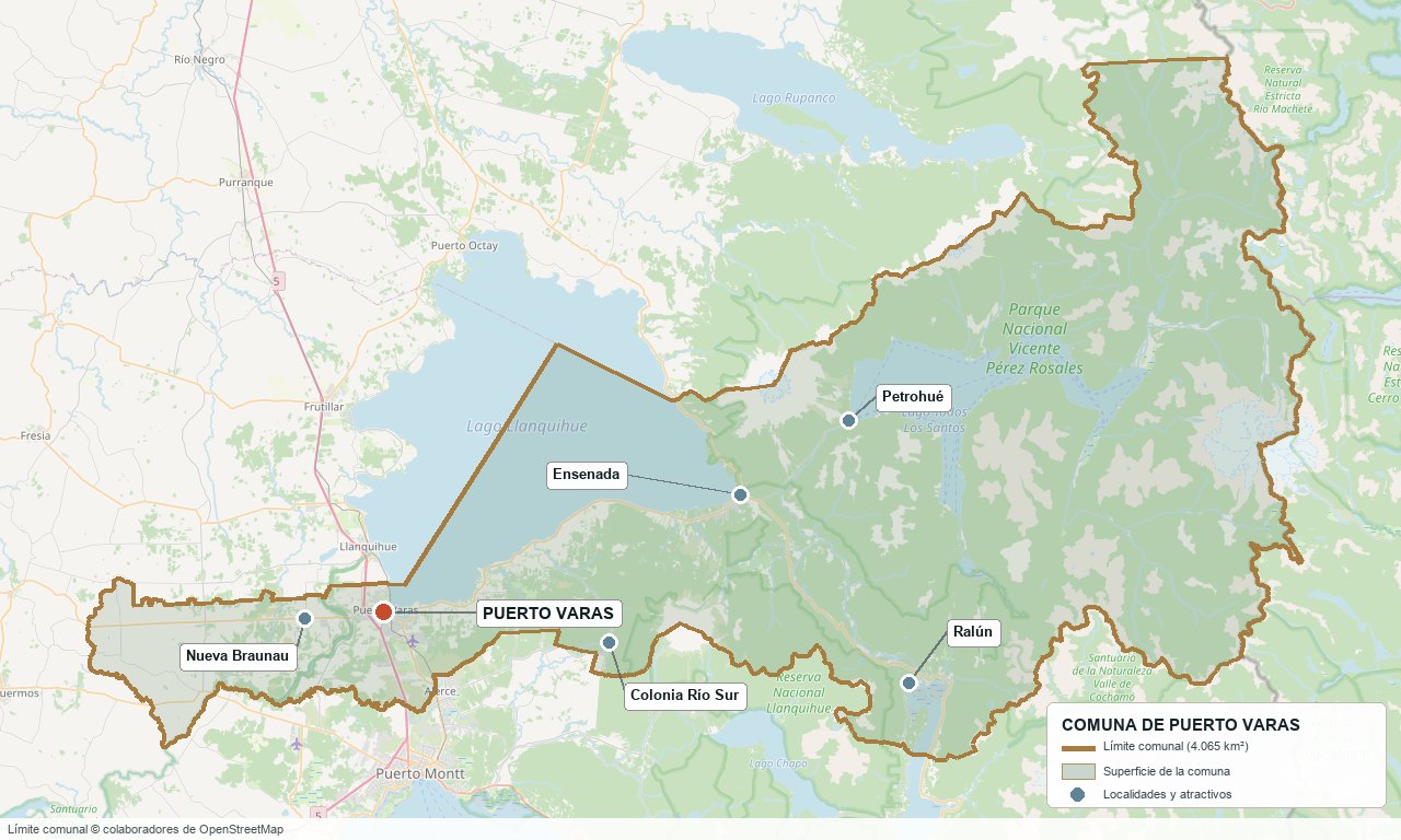
Communal boundary based on OpenStreetMap open data
§ 03 Location, Geography and Territory View
Where Puerto Varas is, what it is built on and why its soil matters.
3.1 Location
The civic centre of Puerto Varas lies at 41°19′04″ S, 72°58′58″ W, 56 m a.s.l., on the southwestern shore of Lake Llanquihue. It is 20 km from Puerto Montt (11 minutes via Route 5) and 1,015 km from Santiago (about 10 hours by road), and since Puerto Montt is the capital of both the Los Lagos Region and Llanquihue Province, the distance to both capitals is the same.
Civic centre of Puerto Varas · 41°19'S 72°59'W
3.2 Terrain and setting
The commune combines two very different landforms. The town and its immediate surroundings sit on the Central Valley (Depresión Intermedia), filled with alluvial, glacial and volcanic sediments that bury ancient moraines from the Llanquihue (14 to 35 thousand years ago) and Santa María (132 to 262 thousand years ago) glaciations. To the east, the communal territory climbs up into the Andes, with the volcanic cones of Calbuco (2,003 m), Osorno (2,652 m), Puntiagudo and Tronador (the highest in the area, 3,490 m, shared with Argentina). The active Liquiñe-Ofqui fault, a strike-slip system more than 1,000 km long, crosses the eastern part of the commune near Ensenada.
3.3 Hydrography
Main bodies of water in the commune4 rows
| Watercourse | Role in the territory |
|---|---|
| Lago Llanquihue | 860 km², the second-largest lake in Chile; the town's urban edge and tourism axis; its only natural outlet is the Maullín River, to the west. |
| Lake Todos los Santos | 177 km² and up to 337 m deep, entirely within Vicente Pérez Rosales National Park; it is the source of the Petrohué River. |
| Petrohué River | 36 km long with a 2,689 km² basin; it forms a delta where it flows into the Ralún inlet, in the Reloncaví estuary. |
| Maullín River and smaller streams | Western outlet of Lake Llanquihue; it also receives the Negro River and streams such as the Arrayán and the Minte. |
3.4 Soils
The commune's soils are mostly Andisols of volcanic origin —known locally as trumaos and ñadis— formed on ash deposited during the Holocene. An agrological study by CIREN classifies only 55.2% of the communal territory into land-use capability classes II, III, IV, VI, VII and VIII, and leaves 35.9% unclassified, largely because it corresponds to Vicente Pérez Rosales National Park. The best land (classes II and III) is concentrated on the flat terraces by the lake and along the road to Ensenada; classes VI to VIII, suited to forestry or protection, dominate the slopes towards the Calbuco volcano and the Petrohué River valley. In short, the commune has no calling for extensive agriculture —cropland is concentrated in a narrow ring around the town and Nueva Braunau— and much of its rural area is forestry land, not productive in the agricultural sense.
- Advantage: the flat terraces by the lake and along the road to Ensenada have the best soils in the commune (classes II-III), and they are also the ones with the greatest appreciation thanks to their views.
- Limitation: more than half of the classified territory is forestry or protection land (classes VI-VIII); a typical “rural parcel (parcela de agrado)” on the outskirts is not cropland, even if it is sold with that image.
- Risk: the volcanic soils of this commune are prone to erosion when native forest is cleared for subdivisions, a problem the Municipality itself has denounced (see Section 10).
- Real estate implication: it is worth asking for the land-use capability class before buying a rural parcel; lot size says little if half of that area is a slope suited only to forestry.
§ 04 Climate and Seasonality View
A mild, rainy climate that shaped the colonists' architecture and today sets the tourism calendar.
Puerto Varas has a Cfb climate —temperate oceanic with no dry season, according to the Köppen classification— in the Central Valley where the town sits; towards the mountains the climate shifts to Cfc (cool, rainy temperate) and on the summits to ETH (high-altitude tundra), according to the report of the Communal Zoning Plan (PRC). The average annual temperature in town is 10.7 °C, with a moderate range thanks to the tempering influence of the lake and the sea.
Reference climate parameters (1991-2021 normal, climate-data.org)9 rows
| Parameter | Value | Comment |
|---|---|---|
| Köppen classification | Cfb | Rainy temperate with no dry season |
| Mean annual temperature | 10.7 °C | Annual range of 8.3 °C |
| Warmest month | February, 15.1 °C | Peak tourist season |
| Coldest month | July, 6.8 °C | Mid-winter in the Southern Hemisphere |
| Annual precipitation | 1,965 mm | Concentrated in autumn and winter |
| Wettest month | June, 268 mm | Almost a third of the winter rainfall |
| Driest month | January, 84 mm | Coincides with the tourist season |
| Average relative humidity | ≈82% | Highest in June (89%), lowest in January (75%) |
| Annual hours of sunshine | ≈1,981 hours | Highest in January, lowest in June |
Autumn and winter (May to August) account for more than half of the annual rainfall, while December to March —the peak tourist season— is also the driest period: the same curve that explains the steep roofs of German architecture also explains the seasonality of the hotel business.
Over the last decade the Los Lagos Region has seen episodes of greater variability in rainfall and water supply and, in May 2025, an event with no documented precedent in the area: an EF-1 tornado struck the town of Puerto Varas directly (see Section 5), raising the question of whether exposure to extreme events is changing.
§ 05 History: 170 Years on a Timeline View
From the German colonisation of 1853 to the tornado of 2025: a history of refoundings, natural disasters and an identity that never stopped blending.
-
Pre-Hispanic
Huilliche territory
The south of Lake Llanquihue was inhabited by Huilliche communities (“people of the south”) devoted to farming, fishing and stonework, before the arrival of explorers and colonists.
-
27 Jun. 1853
Colonisation decree
The government of Manuel Montt orders the colonisation of the southern shore of Lake Llanquihue with European immigrants.
-
Late 1853
212 German colonists arrive
The first 212 German colonists land at La Fábrica, beginning the European settlement of the lake.
-
12 Feb. 1854
Founding of Puerto Varas
Puerto Varas is officially founded under the government of Manuel Montt.
-
1875
Founding of Nueva Braunau
Colonists of Bohemian and Czech origin found Nueva Braunau, today the most populous rural locality in the commune.
-
1885
Club Alemán de Puerto Varas
The Club Alemán (German Club) is founded, an institution of the German community that is still active 140 years later.
-
30 Oct. 1897
Title of Villa
Puerto Varas receives the title of Villa by Decree No. 4838, in honour of minister Antonio Varas.
-
1913
The railway arrives
The State Railways Company (Empresa de los Ferrocarriles del Estado) opens Puerto Varas Station, opposite today's Gran Hotel.
-
1915–1918
Iglesia del Sagrado Corazón
The “German church” is built, inspired by a Black Forest church and today the town's landmark.
-
30 Dec. 1925
Creation of the commune
Supreme Decree No. 8583 officially creates the commune of Puerto Varas.
-
17 Aug. 1926
Chile's oldest park is born
Vicente Pérez Rosales National Park is created, the first in Chile, promoted after former US president Theodore Roosevelt visited the area in 1913.
-
1960–1961
Valdivia earthquake and Calbuco eruption
The largest earthquake ever recorded (May 1960) shakes the province and precedes the eruption of the Calbuco volcano in 1961.
-
1968
The commune of Llanquihue becomes independent
Law 16,854 separates the commune of Llanquihue from the former department of Puerto Varas.
-
1992
Zona Típica and 10 historic monuments
The National Monuments Council declares the heritage quarter (San Ignacio, Estación and Costanera) a Zona Típica (protected heritage district) and protects 10 houses and churches from the German colonisation.
-
22–30 Apr. 2015
Eruption of the Calbuco volcano
The eruption mainly affects Ensenada, with pyroclastic fall and lahars.
-
25 May 2025
EF-1 tornado strikes the town
A tornado with winds of up to 178 km/h leaves 375 homes affected (27 destroyed), 1,086 people displaced and damage estimated at over $31,000 million, with no fatalities.
-
Jul. 2025
A new Zoning Plan comes into force
After 35 years under the 1990 instrument, the new Communal Zoning Plan quadruples the urban boundary, from 546 to 2,200 hectares.
§ 06 Cultural Identity and Indigenous Peoples View
A commune where the German heritage is the most visible, but not the only one.
According to the 2017 Census, 18.5% of the population of Puerto Varas identified as belonging to an Indigenous people, well above the national 12.4% in the same survey. Using another metric —the Social Household Registry (Registro Social de Hogares, RSH)— the Los Lagos Region as a whole recorded 25.7% Indigenous population in June 2023, compared with 9% nationwide; there is, however, no specific, verified RSH figure for the commune, so the two figures should be read as different instruments and not averaged.
The cultural layers of Puerto Varas3 rows
| Tier | Visible traces today |
|---|---|
| Huilliche heritage | Place names of rivers, lakes and volcanoes (Llanquihue, Petrohué, Calbuco); a municipal Indigenous Peoples Office, active in certifying Indigenous status and supporting communities and associations. |
| German colonisation (from 1853) | Zona Típica and 10 historic monuments; Club Alemán (1885); Colegio Alemán (founded 1857); Museo Antonio Felmer in Nueva Braunau; Kuchen Day every February. |
| Chilote contribution | Curanto and native potato cuisine, present in the local food scene, historically linked to the workers from Chiloé who came to work the land and sea of the lake district. |
In everyday life the blend shows more in the built landscape and at the table than in any single official narrative: a German shingled façade may stand a few metres from a curanto restaurant, and Huilliche surnames share the map with names such as Kuschel, Opitz or Hitschfeld, which give their names to the heritage houses of the Zona Típica.
§ 07 Key Demographic Data View
7.1 Population and growth
Demographic indicators compared9 rows
| Indicator | Commune | Region | Country |
|---|---|---|---|
| Population, 2017 Census | 44,578 | — | 17,574,003 |
| Population, 2024 Census | 52,942 | 890,284 | 18,480,432 |
| Change between censuses 2017-2024 | +18.8% | — | 5.2 % |
| Commune area | 4,065 km² | — | — |
| Population density (2024) | ≈13.0 inhab./km² | — | — |
| Population born abroad (2024 Census) | 5.4 % (2,872 people) | — | 8.7 % |
| Sex ratio 2024 | 95.2 | 96.5 | 94.3 |
| Demographic Dependency Ratio (IDD) 2024 | 47.1 | 45.3 | 46.5 |
| Elderly Index (IAM) 2024 | 59.3 | 75.8 | 79.0 |
7.2 Age structure (2024 Census)
Population distribution by age group5 rows
| Age group | Population 2024 | % Commune |
|---|---|---|
| 0 – 14 years | 10,650 | 20.1% |
| 15 – 29 years | 9,160 | 17.3% |
| 30 – 44 years | 13,558 | 25.6% |
| 45 – 64 years | 13,261 | 25.0% |
| 65 years and over | 6,313 | 11.9% |
The most significant demographic trend is not visible in the 2024 snapshot but in the speed of change: between 2017 and 2024, Puerto Varas recorded the largest increase in the population aged 60 and over in the entire Los Lagos Region (+45.9%), far above the regional average (+30.5%). The commune is growing, and it is ageing faster than its neighbours.
Puerto Varas grew 18.8% between censuses —almost four times the national average (5.2%)—, one of the highest rates of population growth in the region, driven by migration to the south linked to tourism and remote work.
§ 08 Economic and Socioeconomic Data View
8.1 Poverty and social indicators (CASEN 2022)
Social indicators compared5 rows
| Indicator | Commune | Region | Country |
|---|---|---|---|
| Income poverty, Casen 2022 | 2.1 % | 7.0 % | 6.5 % |
| Multidimensional poverty, Casen 2022 | 14.0 % | 19.7 % | 16.9 % |
| People in households lacking basic services | 16.7 % | — | 13.1 % |
| Overcrowded households | 7.1 % | — | 8.1 % |
| Foreign population, Social Household Registry (Jan. 2024) | 3.4 % | — | 6.7 % |
Puerto Varas has markedly lower poverty than the regional and national averages on both measures, consistent with a high-value tourism services economy. But there is one significant exception: 16.7% of people live in households lacking basic services, above the national 13.1% —a direct reflection of the fact that much of the rural territory still depends on private wells and incomplete Rural Drinking Water (Agua Potable Rural) committees (see Section 13).
8.2 Economic activity (SII) and municipal finances (SINIM)
Business structure 2023 and municipal finances 20247 rows
| Economic indicator (SII / SINIM) | Value |
|---|---|
| Total businesses (SII 2023) | 7,338 (4,288 micro, 1,351 small, 207 medium, 76 large) |
| Reported salaried employees | 38,738 |
| Sector with the most businesses | Retail and wholesale trade: 1,559 businesses, 4,724 workers |
| Sector with the most workers | Agriculture, forestry and fishing: 579 businesses, 6,228 workers |
| Total municipal revenue 2024 | M$22,626 million |
| Permanent own revenue (IPP) 2024 | 65.1% of total revenue |
| Dependence on the Municipal Common Fund (FCM) 2024 | 13.4% of total revenue |
The business structure confirms a typical pattern: trade has the most businesses, but it is not the largest employer. That place goes to “agriculture, forestry and fishing” —an SII category that also includes support services for aquaculture and livestock in the commune's rural areas—, with 6,228 reported salaried employees.
§ 09 The Economic Engine: Tourism and Aquaculture Services View
Puerto Varas does not live off dairy or the salmon farms themselves: it lives off hosting visitors and off the technology that the neighbouring aquaculture industry needs.
9.1 Tourism
Tourism is, beyond dispute, the engine of Puerto Varas. The commune has around 480 tourism-related businesses and receives approximately one million visitors a year, according to the local Tourism Promotion Corporation. In the summer of 2022 the “Lake Llanquihue basin” —with Puerto Varas at its centre— was Chile's top destination for domestic and foreign tourists, with 96.9% occupancy in tourist accommodation. Vicente Pérez Rosales National Park, within the commune, received around 600,000 visitors in recent years (392,000 in 2021).
Puerto Varas and its neighbours: hotel capacity within the Lake Llanquihue ZOIT4 rows
| Commune | Tourist beds | Role within the zone |
|---|---|---|
| Puerto Varas | 6,348 | Has more beds than the other three communes of the ZOIT combined |
| Frutillar | 1,212 | Teatro del Lago and the Semana Musical de Frutillar music festival |
| Puerto Octay | 1,149 | Oldest German colonisation on the lake, a more secluded character |
| Llanquihue | 896 | Industrial and residential town by the lake |
In July 2025 the municipality launched its first Tourism Development Plan (PLADETUR), with a 2030 horizon, and the Lake Llanquihue Zone of Tourist Interest (ZOIT) —declared in 2021 and extended for another 4 years in 2025— coordinates the joint promotion of the basin's four communes.
9.2 Services and technology for aquaculture
Contrary to common assumption, the big salmon farming companies (Mowi Chile, Cermaq) have their administrative headquarters in Puerto Montt, not in Puerto Varas. What did settle in Puerto Varas is the industry's highest value-added layer of technical services: Innovasea moved and expanded its office and laboratory to the town; Benchmark Genetics has the head office of its Chilean operation here; and Sudvet/Tecnovax, which specialises in botanical inputs to replace antibiotics in salmon farming, expanded from Puerto Varas to offices in Norway and Australia in 2026. The AquaSur trade fair —the world's largest aquaculture fair, with 558 exhibitors and a record 30,959 visitors at its 2026 edition— is held in the La Laja area, on the boundary between Puerto Varas and Puerto Montt.
9.3 Other economic pillars
- Construction and real estate: the visible engine of the past decade (see Section 10 for details on prices and the recent boom-and-correction cycle).
- Trade and professional services: the sector with the most businesses in the commune (1,559), reflecting a town that serves as a supply centre for tourism and for the rural localities.
- Agriculture and livestock: present in the rural ring near Nueva Braunau, but without the weight they carry in the regional dairy basin in communes such as Río Bueno, Osorno or Puerto Octay, which together account for 35.5% of dairy production in Los Lagos; strictly speaking, it is not a distinguishing productive pillar of Puerto Varas.
§ 10 Real Estate Market View
10.1 Available properties and property types
The Puerto Varas market is concentrated in three products: rural parcels with or without lake views in the rural ring (Nueva Braunau, Colonia Río Sur, Route 225 towards Ensenada), new apartments on the lakefront and in the centre, and houses in gated communities with access to the shore. Portalinmobiliario, Yapo and local brokers are the usual references; Produncan also maintains its own active portfolio in the commune.
10.2 Prices by property type (indicative, September 2026)
The price of a parcel of the same size —5,000 m², the most common lot in the commune's projects— can vary by up to four times depending on two variables: whether it already has a house built on it and how far it is from the centre. The following table shows this with the ranges observed in the current market, as of September 2026.
Indicative price ranges by property type and location8 rows
| Property type | Indicative price range | Notes |
|---|---|---|
| 5,000 m² parcel with house, close to town | UF 7,100 – 15,400 (≈$291–636 million) | Houses of 95 to 245 m² built area, in subdivisions located 10 to 25 minutes from the centre along the road to Ensenada or the road to Chinquihue |
| 5,000 m² parcel without house, close to town | $65,000,000 – $206,000,000 (≈UF 1,570–4,990) | 4-15 minutes from the centre; these are subdivisions with services already in place, where buyers build at their own pace and to their own design |
| 5,000 m² parcel with house, in Ensenada or along the road to Ensenada (outskirts) | $125,000,000 – $270,000,000 (≈UF 3,030–6,540) | Houses of 90 to 300 m², 40-45 minutes from the centre, concentrated around Ensenada, on the way to Vicente Pérez Rosales National Park |
| 5,000 m² parcel without house, in Ensenada or along the road to Ensenada (outskirts) | $55,000,000 – $110,000,000 (≈UF 1,330–2,700) | 30-50 minutes from the centre, in Ensenada-area subdivisions where lots are still being sold |
| House in a gated community with private lake access | UF 21,000 – 45,000 (≈$867–1,846 million) | Houses of 180 to 440 m²; lake access may be exclusive to the lot or shared within the community, with a jetty or boat ramp depending on the project |
| Urban land (centre) | UF 18 – 29 per m² | On streets in the town centre (Purísima, San Francisco, Colón); several listings are advertised as “centre” while actually being 3 km or more away: it is worth checking the exact address |
| House in a residential area (no large plot) | UF 5,800 – 16,900 (≈$239–698 million) | Lots of 260 to 455 m², houses of 96 to 245 m²; the Philippi area is the one most often cited in current listings |
| New apartment (centre / lakefront) | UF 70 – 144 per m² | Varies with floor area and proximity to the lakefront: the smallest apartments closest to the lake are the most expensive per m² |
The market went through a marked boom between 2020 and 2022 —sales rose by about 80% and house prices rose as much as 25.7% in a year, the biggest increase in Chile at the end of 2021— followed by a clear correction from 2023: the average price per m² fell from 99.88 to 88.43 UF/m² between Q2-2023 and Q2-2024, and by Q2-2025 the market had entered what a specialist report called a “consolidated recession”, with 25.1 months of unsold stock and a price-to-income ratio of 18.1 years —against 9.43 years in Puerto Montt.
10.3 What drives prices in Puerto Varas
Value drivers in this market, ranked by impact5 rows
| Factor | Price impact | How to check it here |
|---|---|---|
| Views of the lake and the Osorno volcano | Very high | Can double or triple the UF/m² of an equivalent lot without a view |
| Proximity to the centre and the lakefront | High | Compare the price per m² of similarly sized lots according to their exact distance from the lakefront or the nearest beach access |
| Drinking water feasibility | High | Confirm whether the lot is within ESSAL's urban concession area or depends on a Rural Drinking Water (APR) committee (see Section 13) |
| Quality and legal status of the subdivision | High | Ask for the subdivision's municipal final approval (recepción municipal); see the risk of irregular subdivisions below |
| Electricity connection (SAESA) | Medium | Confirm whether the lot frontage already has power lines or whether they need to be extended |
§ 11 Land-Use Planning in Puerto Varas View
A Zoning Plan that has just quadrupled the urban boundary, and a real volcanic risk that is clearly localised.
Puerto Varas operated for 35 years under the 1990 Communal Zoning Plan. The Comptroller General's Office (Contraloría) approved the new instrument on 14 May 2025 and it was published in the Official Gazette (Diario Oficial) on 22 July 2025: it quadruples the urban boundary, from 546 to 2,200 hectares, bringing in the peri-urban ring that was already developed de facto. In areas where a minimum of 5,000 m² per dwelling used to be required, subdivision into lots of 1,000 or 2,500 m² is now allowed, and every new subdivision must include access to public roads, urban services, sewerage and drinking water, all at the developer's expense.
Zoning Plan areas and what they allow3 rows
| Zone | Permitted use | Key restriction |
|---|---|---|
| Zona Típica (heritage quarter) | Residential, retail and offices in heritage houses | Municipal outreach documents cite maximum heights of around 7 to 9 metres to preserve the profile of the German houses and the views; it is advisable to confirm this directly with the Municipal Works Department (Dirección de Obras) before planning a project |
| Expanded peri-urban ring (PRC 2025) | Low- to medium-density residential | Minimum subdivision of 1,000-2,500 m² depending on the area; full urban services required at the developer's expense |
| Rural areas outside the urban boundary | Agricultural, forestry, rural parcels under Decree Law (DL) 3,516 | Subject to the actual feasibility of water and electricity; see the risk of irregular subdivisions in Section 10 |
Volcanic risk in this commune is not a remote hypothesis: the Calbuco and Osorno volcanoes rank 3rd and 6th, respectively, in SERNAGEOMIN's national specific-risk ranking. Hazard studies identify lahar fans in Ensenada, in the Petrohué River valley and to the south, in adjoining areas already within the communes of Puerto Montt (Correntoso) and Puerto Octay (Las Cascadas). The town of Puerto Varas proper does not appear as susceptible to lahars or pyroclastic fall in that study: the risk is concentrated in the rural localities in the east and south of the commune.
The most significant heritage protection is the Zona Típica declared in 1992 (extended in 2014), covering about 13 hectares across the San Ignacio, Estación and Costanera areas and protecting 10 historic monuments —including the Iglesia del Sagrado Corazón, Casa Kuschel and the Casona Alemana. On top of this is the Lake Llanquihue Zone of Tourist Interest (ZOIT), declared in 2021 and extended in 2025, which does not restrict construction but does shape the joint promotion and tourism planning of the basin.
§ 12 Neighbourhoods and Areas View
The town is organised around the lakefront and the historic German centre, with a residential ring expanding to the west and south, and a belt of rural localities —some more than 40 km away— that are part of the same commune.
Areas of the commune and their profile6 rows
| Sector | Features | Market profile |
|---|---|---|
| Zona Típica / historic centre | Heritage quarter declared in 1992 (San Ignacio, Estación, Costanera); German houses now occupied by offices, restaurants and shops | The most expensive area in town; height limited to 7-9 m |
| Costanera (lakefront) | Being transformed by the MOP's Parque Costanera (US$9,830 million, works until 2028) along 1.6 km of lakeshore | Front-row lake properties; highest appreciation |
| Nueva Braunau | Rural locality founded in 1875 by Bohemian/Czech colonists, 5-10 km from town; its own basic services and shops | Entry point to the market for houses and mid-sized parcels |
| Colonia Río Sur | Rural area of gentle hills with views of the Calbuco, Osorno, Puntiagudo and Tronador volcanoes, next to the Llanquihue National Reserve | Rural parcels; native forest |
| Route 225 (road to Ensenada) | Corridor between the town and the eastern side of Lake Llanquihue, with beaches and direct views of the volcano | Area with lower prices today but greater potential for future appreciation, according to specialist brokers |
| Ensenada and Petrohué | Tourist localities 40-60 km away, gateway to Vicente Pérez Rosales National Park | More of a tourism than a residential focus; documented volcanic risk |
§ 13 Basic Services, Utilities and Digital Connectivity View
Practical information that rarely appears in descriptions of a commune but that nonetheless determines whether any property is viable.
Service providers and coverage6 rows
| Service | Provider / operator | Practical notes |
|---|---|---|
| Electricity | SAESA (Grupo Saesa) | Its own office at San Francisco 641, Puerto Varas |
| Urban drinking water and sewerage | ESSAL | Broad urban coverage, but with a history of more than 200 irregular stormwater connections detected; ESSAL invested over $2,000 million in upgrades and two storm tanks to protect the lake |
| Rural drinking water (APR) | Local committees and cooperatives | Partial coverage: in 2025 the municipality unblocked 3 APR projects worth $1,900 million for Termas de Ralún, Colonia Tres Puentes and Los Coihues; the mayor himself acknowledges that “dozens of homes” still have no drinking water |
| Gas | Distribution in cylinders (Lipigas, Abastible) | There is no natural gas network in the commune |
| Internet and phone | Telsur (Grupo GTD) | The area's long-standing operator: in 1989 it pioneered a fibre-optic link between Puerto Montt and Puerto Varas |
| Waste collection | Municipal Sanitation Department / Interaseo | Final disposal at the “La Laja” landfill; composting programme with more than 700 participating families |
§ 14 Health View
The largest tourist commune in the region still has no public hospital of its own in operation, but it is already building one.
Puerto Varas belongs to the Reloncaví Health Service, within the “Llanquihue Norte” territory. It currently has no public hospital of its own in operation: low-complexity inpatient care is provided through an agreement with the Fundación Hospital San José de Puerto Varas (formerly Clínica Alemana), and emergencies are handled at the SAR Puerto Varas (High-Resolution Emergency Care Service), designated by the MINSAL as the main emergency centre in the area.
The commune's health network4 rows
| Facility | Type | Detail |
|---|---|---|
| Fundación Hospital San José | Agreement, low complexity | Formerly Clínica Alemana; handles inpatient care until the new hospital opens |
| SAR Puerto Varas | High-resolution emergency care | Next to the CESFAM; the commune's main emergency entry point |
| CESFAM (family health centre), 6 rural health posts and 1 clinic | Primary care | 12 health facilities in total according to the report of the National Congress Library (BCN) |
| Hospital de Puerto Varas (under construction) | Medium complexity, 190 beds | 7 floors, ≈59,000 m², 42 consulting rooms, 8 operating theatres, 25-chair haemodialysis unit; construction 46-50% complete by mid-2026 |
The new Hospital de Puerto Varas, with an investment of more than $140,000 million, is the project expected to end, towards the close of this decade, the current dependence on Puerto Montt for almost all hospital admissions.
§ 15 Education View
15.1 School education
Puerto Varas had 37 schools in 2022 (14 state-subsidised private, 5 fee-paying private and no municipal schools), with a total enrolment of 11,555 students. “Zero municipal” does not mean an absence of public education: since 2021 the former municipal schools have been run by the Llanquihue Local Public Education Service (SLEP), which manages public education in Puerto Varas together with four other communes.
Notable schools2 rows
| Facility | Type of school | Notes |
|---|---|---|
| Colegio Alemán de Puerto Varas | Fee-paying private, bilingual | Founded in 1857; offers the International Baccalaureate (IB) |
| Colegio Puerto Varas, Colegio Germania, Colegio Patagonia | Fee-paying private schools | The four schools (together with the Alemán) with the best SIMCE 2025 scores in the commune |
In SIMCE 2025 (Chile's national standardised tests), Puerto Varas's communal averages were above the regional mean in every grade and subject assessed (4° básico, 8° básico and II medio, i.e. grades 4, 8 and 10), although the four best-performing schools are all fee-paying private schools. The gap by school type is real and long-standing: in the 2021 PSU (university entrance exam), the commune's municipal schools obtained 44.8% of scores above 450 points, compared with 95.5% in fee-paying private schools.
15.2 Higher education
Puerto Varas currently has no university or professional institute campus in operation. The private Universidad de Puerto Varas existed between 2002 and 2005, when the Higher Education Council (Consejo Superior de Educación) revoked its official recognition due to financial difficulties; its students were absorbed by the Universidad San Sebastián. Today, anyone studying for a university degree depends on campuses in Puerto Montt (Universidad de Los Lagos, Universidad Austral, Universidad San Sebastián, Universidad Santo Tomás, INACAP) or in Osorno.
§ 16 Lakes, Volcanoes and Natural Surroundings View
Puerto Varas is, above all, the most direct gateway to the natural surroundings of the Llanquihue basin: the lake itself laps the town, and from its lakefront the routes set out to the Osorno volcano, Vicente Pérez Rosales National Park and Lake Todos los Santos.
Natural attractions by distance from town5 rows
| Attraction | Approx. distance | Activities |
|---|---|---|
| Lago Llanquihue | 0 km (urban shoreline) | Lakefront, water sports, scenic boat trips |
| Calbuco volcano (2,003 m) | Within the communal territory, towards Ensenada | Sightseeing; hiking access restricted due to volcanic activity |
| Osorno volcano (2,652 m) | 45-62 km depending on the access route | Ski centre, guided ascents, viewpoint |
| Saltos del Petrohué and Vicente Pérez Rosales National Park | 50-64 km | Hiking, rafting on the Petrohué River |
| Lake Todos los Santos | 55-60 km | Catamaran trips to Peulla and the crossing into Argentina |
Lake Llanquihue, Osorno volcano and Vicente Pérez Rosales National Park
Vicente Pérez Rosales National Park, created on 17 August 1926 by Supreme Decree No. 552, is Chile's oldest national park: 253,780 hectares that the commune shares with the mountain range and with Argentina, now managed by the new Biodiversity and Protected Areas Service (SBAP).
§ 17 Connectivity and Transportation View
17.1 Road network
Route 225-CH starts at Puerto Chico, next to the Puerto Varas Harbour Master's Office (Capitanía de Puerto), and runs to the Vicente Pérez Rosales border crossing, at 1,020 m a.s.l. The paved Puerto Varas–Ensenada stretch (about 14 km) was completed in December 1941; from Ensenada to Petrohué the road becomes gravel.
Routes and distances3 rows
| Route / destination | Distance and details |
|---|---|
| Puerto Varas – Puerto Montt | 20 km via Route 5, ≈11 minutes |
| Puerto Varas – Ensenada (Route 225) | ≈14 km paved |
| Puerto Varas – Santiago (Route 5) | 1,015 km, ≈10 hours |
Puerto Varas on the Osorno – Puerto Montt axis
17.2 Airport
The reference airport is El Tepual (PMC), in Puerto Montt, about 16 km from Puerto Varas, with flights to Santiago, Punta Arenas, Osorno, Concepción and Balmaceda.
17.3 Road, urban and rail transport
- Bus terminal: Tur Bus has its own terminal; Cruz del Sur also operates here.
- Lake transport: short scenic trips on Lake Llanquihue (not a regular point-to-point service); the international “Cruce Andino” catamaran promoted from Puerto Varas actually sails Lake Todos los Santos, between Petrohué and Peulla, on the way to Bariloche.
- Rail: Puerto Varas Station, opened in 1913, stopped operating in 2007 and went more than 20 years without passenger service; it reopened on 22 April 2025 as a stop on the Llanquihue–Puerto Montt train.
§ 18 Tourism: Development, Attractions and Things to Do View
18.1 Tourism development
Puerto Varas's first Tourism Development Plan (PLADETUR), with a 2030 horizon, was launched in July 2025 after a participatory process. The Lake Llanquihue Zone of Tourist Interest (ZOIT), declared in 2021 and extended in 2025, coordinates the joint promotion of Puerto Varas, Frutillar, Puerto Octay and Llanquihue.
18.2 Tourist attractions in the commune
- Osorno volcano: an almost symmetrical 2,652 m cone, with a ski centre and guided ascents.
- Saltos del Petrohué: waterfalls over volcanic rock, within Vicente Pérez Rosales National Park.
- Lake Todos los Santos: a historic navigation route to Peulla and the crossing into Argentina.
- Vicente Pérez Rosales National Park: the oldest in Chile, created in 1926.
18.3 Museums and culture
- Museo Antonio Felmer (German Museum): in Nueva Braunau, 9 km from town; founded in 1975, it houses objects from the German colonisation in a three-storey barn.
- Zona Típica and heritage houses: Casa Kuschel, Casa Yunge, the Casona Alemana and the Iglesia del Sagrado Corazón, all National Monuments since 1992.
18.4 Food and dining
German baking is the town's culinary signature, with Kuchen Day on the first Saturday of every February in the Plaza de Armas.
- Cervecería Bosques: road to Ensenada (Route 225), km 8.2.
- Cervezas Bordelago: also on Route 225, on the road to Ensenada.
- Chester Beer: Fundo Molino Viejo, on the road to Frutillar.
18.5 Nature and the outdoors nearby
- Rafting on the Petrohué River: snowmelt waters over a volcanic riverbed.
- Hiking on the Osorno volcano and in Vicente Pérez Rosales Park: guided access depending on the season and volcanic activity.
18.6 Calendar of events and traditions
Main events of the year5 rows
| Period | Event | Character |
|---|---|---|
| First Saturday in February | Kuchen Day | German baking in the Plaza de Armas |
| January-February | Traditional festivals (e.g. “La Papa y el Cordero”, Nueva Braunau) | Traditional food, crafts and rural folklore |
| 30 October | City anniversary | Title of Villa, Decree No. 4838 of 1897 |
| Varies | Mountain Film Festival | Mountain and extreme sports films, affiliated with the IAMF |
| 12 April 2026 | Debut of IRONMAN 70.3 Puerto Varas | The first IRONMAN 70.3-licensed race in Chile (see Section 19) |
§ 19 Everyday Life, Sport and Practical Information View
What you need to know if you are going to live in Puerto Varas, not just visit.
19.1 Sport and identity
On 12 April 2026 Puerto Varas will host the IRONMAN 70.3, the first IRONMAN 70.3-licensed race held in Chile: 1,800 athletes and more than 8,000 visitors are expected, with an estimated economic impact of US$6 to 8 million. The course swims 1.9 km in Lake Llanquihue with the Osorno volcano as a backdrop, cycles 90 km around the lake and runs 21 km along the lakefront.
19.2 Shopping and supplies
The town has a small-format mall, Mall Paseo Puerto Varas (Grupo Pasmar), with a supermarket, cinema and skating rink. The Centro Comercial Buena Vista is under construction (an investment of US$14 million), which will add a Unimarc supermarket and create 80 permanent jobs. For a larger retail offering —department stores, more variety of shops— Puerto Montt remains the reference.
19.3 Where to handle paperwork
Offices based in Puerto Varas4 rows
| Office | Address or contact | Remarks |
|---|---|---|
| Real Estate Registrar (Conservador de Bienes Raíces) | Puerto Varas | Also serves Llanquihue, Frutillar and Fresia |
| Civil Registry (Registro Civil) | San José 242 | Monday to Friday, 08:30-14:00 |
| SII, Puerto Varas Unit | San José 228 | Jurisdiction over Puerto Varas, Cochamó, Fresia, Llanquihue and Frutillar; the Regional Directorate is in Puerto Montt |
| Notary offices | Notaría Espinosa and Notaría Cárcamo | Two notary offices active in the commune; a fourth Puerto Varas notary office is based in Fresia |
19.4 Cost of living and practical considerations
- The average monthly rent for a house in Puerto Varas was $1,038,734 in 2024, 49% more expensive than in Puerto Montt ($697,544).
- Commercial rents are also higher than in Puerto Montt: between 0.4 and 0.7 UF/m² per month, compared with 0.2-0.3 UF/m² in the neighbouring regional capital.
- Puerto Varas has local private healthcare (Interclínica Puerto Varas) for medical specialties, although high-complexity cases are still referred to Puerto Montt.
§ 20 Territorial Analysis: Strengths, Challenges and Opportunities View
An honest reading of the territory. A sound investment decision also requires knowing what doesn't work.
- Established tourism: around one million visitors a year and 6,348 tourist beds, more than its three neighbouring ZOIT communes combined.
- High municipal financial autonomy: 65.1% permanent own revenue and only 13.4% dependence on the Municipal Common Fund.
- Poverty well below the regional average: 2.1% by income versus 7.0% in the Los Lagos Region.
- Architectural heritage unique in the region: a Zona Típica and 10 historic monuments from the German colonisation.
- Gateway to Chile's oldest national park (1926) and to volcanic and lake surroundings unmatched in its neighbouring communes.
- Rapid ageing: it leads regional growth in the population aged 60 and over (+45.9% between 2017 and 2024).
- Documented irregular subdivisions, subject to legal action (San Nicolás, San Ignacio), with acknowledged damage to native forest and groundwater.
- Education gap by school type: 44.8% of PSU scores above 450 points in former municipal schools versus 95.5% in fee-paying private schools (2021).
- 16.7% of the population lives in households lacking basic services, above the national 13.1%, reflecting a Rural Drinking Water network that is still incomplete.
- No public hospital of its own in operation —it depends on an agreement— while the new 190-bed hospital is being completed.
- Real estate market in a correction phase: 25.1 months of unsold stock and a price-to-income ratio of 18.1 years, double that of Puerto Montt.
- The new Zoning Plan (2025) quadrupled the available urban land, which should ease price pressure in the medium term.
- The new Hospital de Puerto Varas (190 beds, under construction) will reduce the historical dependence on Puerto Montt.
- The reactivation of the Llanquihue–Puerto Montt train (April 2025) adds a connectivity option unseen in decades.
- The debut of IRONMAN 70.3 in April 2026 opens a new international showcase, with an estimated impact of up to US$8 million.
- The newly launched PLADETUR 2025-2030 organises public and private investment in tourism in a planned way for the first time.
- Real and localised volcanic risk: the Calbuco and Osorno volcanoes rank 3rd and 6th in SERNAGEOMIN's national specific-risk ranking.
- The EF-1 tornado of May 2025 —with no documented precedent in the area— destroyed 27 homes and exposed a new climate vulnerability.
- Possible increase in property taxes (contribuciones) for owners whose land was reclassified by the new Zoning Plan.
- Sanitation infrastructure under stress: ESSAL has had to invest in correcting more than 200 irregular stormwater connections that were affecting Lake Llanquihue.
Puerto Varas: Territory, Connectivity and Opportunities
Puerto Varas combines something very few Chilean communes have at the same time: a protected and recognisable architectural heritage, first-class natural surroundings on the town's doorstep, an economy diversified between tourism and high-value technical services, and a newly updated Zoning Plan that opens up urban land after 35 years. It is also a commune that is ageing fast, that still provides public healthcare through an agreement, and that carries a history of unregularised rural subdivisions: understanding it well means seeing both sides at once.
At Produncan Lands we know this territory and its opportunities. Our work is to connect properties with people looking to invest, live and develop new projects in southern Chile, offering our experience, local knowledge and commercial reach.
We invite you to explore our properties in Puerto Varas and throughout southern Chile, and to trust Produncan Lands with the sale of your property.
View properties at Produncan Lands§ 22 Sources and Methodology Note View
22.1 Sources consulted
Documents and sources used14 rows
| Scope | Document and year |
|---|---|
| Population and demographics | 2024 Census, INE and Puerto Varas Communal Statistical Report, BCN, 2025 ed. |
| Poverty and social indicators | CASEN 2022 survey, via the BCN 2025 Communal Statistical Report |
| Economic activity | Business Statistics by Commune, SII 2023, via the BCN 2025 Communal Statistical Report |
| Municipal finances | National Municipal Information System (SINIM), 2022 and 2024 data |
| Climate | climate-data.org, Puerto Varas, 1991-2021 normal |
| Geography and soils | Municipality of Puerto Varas, Communal Zoning Plan report (2019) and “Recursos Naturales de la Comuna de Puerto Varas”, CIREN/SIT Rural, 2024 |
| Land-use planning | New Communal Zoning Plan, GORE Los Lagos Resolution No. 44/2025, Emol, August 2025 |
| Volcanic risk | Specific volcanic risk ranking study, SERNAGEOMIN, via El Heraldo Austral |
| Heritage | National Monuments Council — Zona Típica of Puerto Varas |
| Tourism | Undersecretariat of Tourism (Lake Llanquihue ZOIT) and Puerto Varas Tourism Development Plan (PLADETUR) 2025-2030 |
| Health | Health Investment Plan, MINSAL — Hospital de Puerto Varas |
| Education | BCN Communal Statistical Report (2022 and 2023 editions) and Education Quality Agency, SIMCE 2025 |
| Real estate market | USS-Tinsa Real Estate Activity Report, Q2-2024 and Q2-2025 |
| History | Municipality of Puerto Varas — History and Wikipedia, cross-checked against the primary sources cited for each milestone |
22.2 Methodology note and data currency
- The 2024 Census results used in this document are the official data published by the INE; some breakdowns (such as the urban-rural split) were not yet available at communal level when this edition closed and were omitted rather than estimated.
- The number of schools in the commune differs slightly between the BCN Communal Statistical Report (37, with 2022 data) and the municipal PLADECO (43); the BCN figure was used as the most recent one with a documented methodology.
- Real estate price ranges are indicative only and do not constitute an appraisal. Each property must be assessed individually.
- This document does not constitute legal or tax advice.
- Closing date of this edition: September 2026. We recommend reviewing the indicators in sections 7, 8 and 10 annually, and confirming any specific Zoning Plan rule directly with the Municipal Works Department (Dirección de Obras Municipales) before planning any construction.
Territorial reference document prepared by Produncan Lands. It brings together official information (INE, BCN, SII, SINIM, MINEDUC, MINSAL, National Monuments Council, Undersecretariat of Tourism) with local market knowledge, so that anyone —resident, visitor, investor or buyer— can understand Puerto Varas in depth before making a decision.