
Punta Arenascapital of the Strait, gateway to Antarctica
History, Economy and Investment Opportunities at the Southern Tip of Chile
WIND, TIN AND STRAIT
The wind comes in from the west and never lets up: it sweeps across the steppe of the Brunswick Peninsula, rushes down the Río de las Minas and slams into the façades of Plaza Muñoz Gamero before vanishing over the Strait of Magellan. That wind —the same one that doomed Fuerte Bulnes in 1843 and forced the colony to move 8 kilometers north in 1848— is still the first explanation for how people build here: low houses, corrugated zinc roofs painted in bold colors so they stand out against the grey sky, and small windows turned away from the gusts.
Punta Arenas grew rich twice from what the land yields, not from what the scenery promises: first with wool, when the Sociedad Explotadora de Tierra del Fuego ran more than a million sheep across the Patagonian estancias and ships sailed straight to London; then with the gas and oil beneath its soil, ever since the Springhill well produced Chile's first crude in 1945. Today it is attempting a third act: at Cabo Negro, 28 kilometers from the main square, the same gale that wrecks umbrellas powers the world's first synthetic fuels plant.
Anyone who walks through the municipal cemetery —Italian marble mausoleums for families who made their fortune in wool, next to the bronze statue of the Kawésqar Indian that sailors touch before setting sail— understands something no penguin postcard can capture: this is a city of capital, not a seaside village. It governs the region, hosts the scientists heading for the Antarctic ice, and earns its living from natural gas while the rest of Patagonia earns its living from scenery.
Version 1.0 · Expanded edition · September 2026
The Commune at a Glance
The essential facts about Punta Arenas at a glance. Each figure is explained in detail in the corresponding section.
Administrative identification and reference data12 rows
| Fact | Detail |
|---|---|
| Official name | Punta Arenas |
| Region / Province | Magallanes and Chilean Antarctica Region / Magallanes Province |
| Demonym | Puntarenense (colloquially, "pingüino", i.e. penguin) |
| Civic center coordinates | 53°09'46" S, 70°54'29" W (Plaza Muñoz Gamero) |
| Area | 17,846.3 km² · does not include the Chilean Antarctic Territory, which is a separate commune |
| Elevation | 0 – 34 m a.s.l., depending on the measuring point |
| Dialing code | +56 61 |
| Postal code | 6200000 |
| Time zone | UTC−4 (CLT) / UTC−3 in summer time (CLST) |
| Climate classification | Csc (Köppen) — cold temperate with rainfall all year round, with a subpolar oceanic character |
| City anniversary | December 18 (founding, 1848) |
| Municipality | Ilustre Municipalidad de Punta Arenas (municipal government) |
Overview
Punta Arenas is the capital of the Magallanes and Chilean Antarctica Region, and the southernmost city in the world with more than 100,000 inhabitants: 132,363 people (2024 Census) on the shores of the Strait of Magellan, on the Brunswick Peninsula. Its economy rests on a combination no other commune in this series shares: natural gas and oil (ENAP, since 1945), the largest methanol plant in South America (Methanex, at Cabo Negro) and, for the past few years, the world's first synthetic fuels plant (HIF Global). The sheep farming that made it prosperous a century ago is still present on its rural outskirts, but it is no longer the engine: it is the memory.
Its functional role is that of a service capital, not a satellite town: it is home to the most advanced hospital in the entire region, the only state university headquartered south of Puerto Montt (UMAG), the regional Court of Appeals and the airport that links it to the rest of Chile. It is also, by geography and by history, the logistical and scientific departure point for Antarctica: the Chilean Antarctic Institute (INACH) is based here, and the vast majority of the hemisphere's Antarctic tourism and science passes through its port and airport.
What sets it apart from its better-known neighbor in this same series, Puerto Natales, is precisely this: Natales lives off its scenery —it is the gateway to Torres del Paine— and depends almost entirely on seasonal tourism. Punta Arenas lives off public administration, the energy industry and logistics, with tourism as a genuine complement but not the backbone of the economy. It is the difference between a city that welcomes visitors and one that welcomes managers, civil servants, students and scientists all year round.
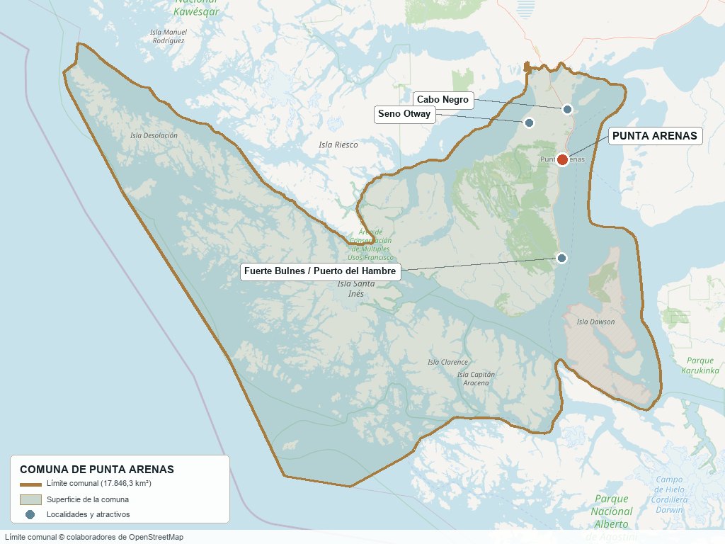
Communal boundary based on OpenStreetMap open data
§ 03 Location, Geography and Territory View
Where Punta Arenas is, what it is built on, and why its enormous size is not what it seems.
3.1 Location
The city lies on the eastern coast of the Brunswick Peninsula, on the northern shore of the Strait of Magellan, at 53°09'46" S and 70°54'29" W. It is 2,180 km from Santiago as the crow flies (3 h 20 min by direct flight) and about 3,005 km by land, a route that does not run entirely through Chilean territory: to get there by car you have to cross into Argentina via the Cardenal Samoré or Casas Viejas pass and re-enter further south, because the Patagonian ice fields and fjords rule out a 100% Chilean mainland route.
Plaza Muñoz Gamero · Civic center (Zona Típica)
3.2 Terrain and setting
The city is built on a low, rolling coastal plain —shaped by passing glaciers— that rarely rises above 34 m a.s.l. To the west, the land climbs toward the hills of the Reserva Nacional Magallanes (Cerro Mirador, between 350 and 600 m a.s.l.), where the steppe gives way to sub-Antarctic forest. But the most surprising fact about this commune is its actual shape: it is not just the Brunswick Peninsula and its immediate rural outskirts, but stretches diagonally southwest across an almost uninhabited archipelago —the islands of Desolación, Santa Inés, Clarence and Capitán Aracena— all the way to the edge of Alberto de Agostini National Park. More than 99% of that area has no roads and no permanent population.
3.3 Hydrography
Main bodies of water in the commune4 rows
| Watercourse | Role in the territory |
|---|---|
| Strait of Magellan | Main body of water; historic interoceanic route and the waterfront of the entire city |
| Río de las Minas | 19.9 km; rises in the Reserva Nacional Magallanes at 500 m a.s.l. and runs through the city center before flowing into the Strait |
| Río Los Ciervos | Rises on the Brunswick Peninsula and flows into the Strait, north of the city |
| Llau-Llau and Bitsch creeks | Smaller urban watercourses with a history of flooding during snowmelt or heavy rain |
3.4 Soils
The dominant soil is steppe —Patagonian pampa of fluvioglacial origin—, suitable for extensive grazing but not for intensive agriculture. Beneath that same soil, around Cabo Negro, there are active natural gas fields: this commune's productive potential lies as much on the surface (livestock) as underground (hydrocarbons).
- Advantage: natural grassland suited to extensive, non-irrigated livestock farming, and a subsoil with natural gas reserves under active production (ENAP).
- Limitation: wind and temperature restrict vegetable growing and open greenhouses; the fertile topsoil layer is thin.
- Risk: landslides in the western hills (slopes of 24% to 58%, zone ZR-2 of the Zoning Plan) and flooding along the banks of the Río de las Minas.
- Real estate implication: the value of rural land in this commune depends on its size and proximity to the city or to the Cabo Negro industrial infrastructure, not on its agricultural productivity.
§ 04 Climate and Seasonality View
Wind, not rain, is what truly shapes life in Punta Arenas.
Punta Arenas has a cold temperate climate with rainfall all year round and a subpolar oceanic character (Köppen Csc), with a mean annual temperature of just 6.5 °C: highs in January-February of around 11 °C and July lows close to 1.4 °C. Annual precipitation is close to 400 mm, spread evenly across the year, with no marked dry season.
Reference climate parameters10 rows
| Parameter | Typical value | Comment |
|---|---|---|
| Köppen classification | Csc | Cold temperate, rain all year round, subpolar oceanic |
| Mean annual temperature | 6.5 °C | Low temperature range; there are no hot summers |
| Record high temperature | 29.9 °C | Extreme reading, not representative of a typical summer |
| Record low temperature | −16 °C | Extreme winter reading |
| Average annual wind speed | 21.8 km/h | Predominantly from the west, all year round |
| Highest recorded gust | 146 km/h | Airport weather station, March 2021; the strongest in 28 years |
| Sunshine hours | ≈39% of the maximum possible | Up to 17-18 h of daylight at the December solstice; ≈7.5 h in June |
| Average relative humidity | ≈80% | Highest in June (87%), lowest in summer (72%) |
| Wettest month | March | ≈46 mm (reference value) |
| Driest month | September | ≈24 mm (reference value) |
Rainfall is spread almost evenly throughout the year —without the pronounced dry summer found further north— because the regime is subpolar oceanic, not Mediterranean: here the defining element of the climate is not rain but wind, which blows from the west 365 days a year and reaches its strongest gusts precisely in the driest months (spring and summer).
Unlike central and northern Chile, this commune does not face water scarcity: water is plentiful. The climate variable that is really monitored here is the consistency of the wind, because the region's long-term energy bet (wind farms and synthetic fuels), which it is building for the coming decade, depends on it.
§ 05 History: 178 Years on a Timeline View
A city that moved because of the wind, grew rich on wool, lost its shipping route to the Panama Canal and reinvented itself with oil.
-
Pre-Hispanic
Aonikenk and Kawésqar
The lands around the Strait are inhabited by the Aonikenk (Southern Tehuelche), guanaco hunters of the steppe, and the Kawésqar, nomadic canoe people of the western channels and islands.
-
1520
Ferdinand Magellan sails through the strait
Between October 21 and November 28, Magellan's expedition discovers and navigates the passage that would link the Atlantic with the Pacific and bear his name.
-
21 Sep 1843
Chile takes possession of the Strait
Commander Juan Williams, in command of the schooner Ancud, formally takes possession of the Strait of Magellan for Chile at Punta Santa Ana.
-
30 Oct 1843
Founding of Fuerte Bulnes
The fort, named in honor of President Manuel Bulnes, is inaugurated as the first Chilean settlement on the Strait.
-
1848
Relocation and founding of Punta Arenas
Fuerte Bulnes fails for lack of water, firewood and shelter from the wind; the entire colony moves 18 km north and founds Punta Arenas on December 18.
-
1847 – 1870s
Penal colony
Punta Arenas operates as a penal colony: by 1881, about 90% of its population were common criminals, political prisoners and soldiers exiled from Santiago.
-
1876
Sheep farming arrives
Governor Diego Dublé Almeyda brings the first flock of sheep from the Falkland (Malvinas) Islands, launching the activity that would define the regional economy for seven decades.
-
1893
Sociedad Explotadora de Tierra del Fuego
José Menéndez, Mauricio Braun and José Nogueira form the company that came to control more than 1.3 million hectares of grazing land, the largest sheep-farming empire in Patagonia.
-
1880 – 1914
The golden age
Mass Croatian and Spanish immigration, fueled by gold and wool: the population grows from 3,000 to more than 17,000 inhabitants. Today about 10% of the people of Magallanes have Croatian ancestry.
-
1914
The Panama Canal opens
Interoceanic traffic shifts north and Punta Arenas loses its status as an obligatory port of call, forcing a long-term economic readjustment.
-
1920
Crackdown on the Federación Obrera de Magallanes
In July, the workers' union headquarters is attacked and set on fire by civilians, police and soldiers, in one of the harshest episodes of the cycle of repression known as the "Patagonia trágica" (Tragic Patagonia).
-
1945 – 1950
The oil industry is born
The Springhill well delivers Chile's first commercial oil in 1945; on June 19, 1950 ENAP is created, giving rise to the hydrocarbon industry that would replace wool as the economic engine.
-
1949
Magnitude 7.5 earthquake
A major earthquake, with its epicenter on the Magallanes fault near Cape Froward, shakes the region, with aftershocks continuing until February 1950.
-
1977
Punta Arenas Free Trade Zone
Officially inaugurated on September 12, consolidating the special tax regime designed to offset the geographic isolation of this extreme zone.
-
2012
Río de las Minas flash flood
In March, the river overflows and floods part of the city center, prompting stricter risk regulations along its banks.
-
2020s
Green hydrogen and Antarctic tourism capital
HIF Global builds the world's first synthetic fuels plant at Cabo Negro, while Antarctic tourism and science establish Punta Arenas as the gateway to the white continent.
§ 06 Cultural Identity and Indigenous Peoples View
Most of today's Indigenous population does not descend from the peoples who historically inhabited the Strait.
According to the Social Household Registry (RSH, March 2025), 4.7% of the commune's population belongs to Indigenous peoples, a figure similar to the national average (9.2%, although measured with a different instrument). But the key fact for understanding local identity lies elsewhere: the overwhelming majority of those who self-identify as Indigenous in Punta Arenas are of Mapuche origin, arriving through internal migration from south-central Chile during the 20th century —not descendants of the historically southern peoples—. The Aonikenk (Tehuelche) have practically ceased to exist as a distinct ethnic group following the expansion of sheep farming, while the Kawésqar maintain a small but active presence, today mostly urban, in Punta Arenas and Puerto Edén.
The cultural layers of Punta Arenas5 rows
| Tier | Visible traces today |
|---|---|
| Aonikenk (Tehuelche) | Historic hunters of the steppe; no significant distinct presence today, except in historical and museum records |
| Kawésqar | Canoe people of the western channels; active urban communities in Punta Arenas (land registry and procedures before CONADI), heritage collection at the Museo Salesiano |
| Croatian and Spanish settlers (1880-1914) | Croatian Quarter (Barrio Croata), Club Croata de Punta Arenas (111 years old in 2026), cobbled streets in the style of the island of Brač |
| Internal Mapuche migration (20th c.) | Today the largest Indigenous group in the commune by number, with no prior territorial ties to the area |
| Recent migration | 6.0% of the population born abroad (2024 Census); the figure rises to 20.2% according to the Social Household Registry of March 2025, which specifically captures recent migrant households applying for social benefits |
This mix shows up in everyday life more than in the statistics: the Museo Salesiano Maggiorino Borgatello displays Selk'nam, Kawésqar and Yagán pieces alongside remains of the mylodon brought from Puerto Natales; the Club Croata runs active community events more than a century after its founding; and the monument to the Kawésqar Indian in Plaza Muñoz Gamero —whose foot generations of sailors have touched before setting sail to ensure their return— is, together with the statue of Ferdinand Magellan, the image the city chose to represent itself.
§ 07 Key Demographic Data View
7.1 Population and growth
Demographic indicators compared9 rows
| Indicator | Commune | Region | Country |
|---|---|---|---|
| Population, 2017 Census | 131,592 | — | 17,574,003 |
| Population, 2024 Census | 132,363 | 166,537 | 18,480,432 |
| Intercensal change 2017-2024 | +0.6 % | — | 5.2 % |
| Commune area | 17,846.3 km² | — | — |
| Population density (2024) | 7.4 inhab./km² | — | — |
| Population born abroad (Census) | 6.0 % | 6.6 % | 8.7 % |
| Sex ratio 2024 | 96.6 | — | 94.3 |
| Demographic Dependency Ratio (IDD) 2024 | 45.5 | — | 46.5 |
| Elderly Index (IAM) 2024 | 90.5 | — | 79.0 |
7.2 Age structure (2024 Census)
Population distribution by age group5 rows
| Age group | Population 2024 | % Commune |
|---|---|---|
| 0 – 14 years | 21,733 | 16.4 % |
| 15 – 29 years | 26,158 | 19.8 % |
| 30 – 44 years | 31,108 | 23.5 % |
| 45 – 64 years | 33,691 | 25.5 % |
| 65 years and over | 19,673 | 14.9 % |
The defining trend in this demographic picture is stagnation combined with aging: barely 0.6% growth in seven years —an almost flat figure by Chilean standards—, with an elderly index that already nearly equals the child population. The sex ratio has also reversed: from 102.7 in 2012 (more men, typical of a resource-extraction economy) to 96.6 in 2024 (now more women than men).
The population is overwhelmingly urban: 94.8% live in the city of Punta Arenas and only 5.2% in the rest of the commune's 17,846 km². Punta Arenas also accounts for 79.5% of the population of the entire Magallanes Region: it is, by far, the region's demographic center.
§ 08 Economic and Socioeconomic Data View
8.1 Poverty and social indicators (CASEN and Social Household Registry)
Social indicators compared6 rows
| Indicator | Commune | Region | Country |
|---|---|---|---|
| Income poverty, Casen 2022 | 3.5 % | 3.4 % | 6.5 % |
| Multidimensional poverty, Casen 2022 | 7.1 % | 6.9 % | 16.9 % |
| People in households lacking basic services | 6.7 % | — | 13.1 % |
| Overcrowded households | 5.1 % | — | 8.1 % |
| Indigenous population (RSH, Mar. 2025) | 4.7 % | — | 9.2 % |
| Foreign population (RSH, Mar. 2025) | 20.2 % | — | 6.7 % |
Punta Arenas shows markedly lower poverty than the national average on both measures —less than half the national rate—, reflecting high formal wages tied to the energy industry, the port and regional public employment. The gap between the 6.0% foreign-born population recorded by the Census and the 20.2% captured by the Social Household Registry is not an error: the RSH measures households actively applying for social benefits, and the difference suggests a recent wave of migration not yet fully reflected in the census figures.
8.2 Economic activity (SII) and municipal finances (SINIM)
Business structure and municipal finances9 rows
| Economic indicator (SII / SINIM) | Value |
|---|---|
| Total businesses (2023) | 12,443 (micro 7,637 · small 2,187 · medium 265 · large 113) |
| Reported salaried workers (2023) | 65,854 |
| Retail and trade businesses / workers | 3,634 businesses · 10,453 workers |
| Construction businesses / workers | 1,234 businesses · 13,161 workers |
| Agriculture and fishing businesses / workers | 897 businesses · 3,599 workers |
| Total municipal revenue (2024) | M$69,620,442 |
| Permanent own-source revenue (2024) | 35.6% of the total (M$24,758,659) |
| Municipal Common Fund transfers received (2024) | 15.8% of the total (M$10,976,302) |
| Total municipal spending (2024) | M$71,913,435 (higher than revenue for the period) |
The business structure reveals something that simply counting companies does not: retail has three times as many businesses as construction (3,634 versus 1,234), but construction employs more people (13,161 versus 10,453). Real employment in the commune rests on construction and industry —tied to the investment cycles of ENAP, Methanex, HIF and the port— more than on retail, which dominates in number of businesses but not in payroll.
§ 09 The Productive Engine: Hydrocarbons, Methanol and Green Hydrogen View
Why the economy of Punta Arenas depends not on its scenery, but on what lies beneath the steppe.
9.1 Hydrocarbons: ENAP Magallanes
Chile produced its first oil at the Springhill well (Tierra del Fuego) on December 29, 1945; ENAP was established as a company on June 19, 1950. Almost 80 years later, ENAP Magallanes is still operating in the commune: more than 4 million m³ of natural gas per day in 2024, with 33 wells drilled and 28 fractured that year alone, and an announced investment of between US$500 and US$649 million for 2023-2027 in new unconventional drilling (the Arenal, Dorado-Riquelme and Manzano blocks).
The three industrial pillars of Cabo Negro and their scale3 rows
| Company | Product | Scale |
|---|---|---|
| ENAP Magallanes | Natural gas and oil | +4 million m³/day of gas (2024); ~1,100 direct jobs, value chain estimated at more than 3,000 families |
| Methanex (Cabo Negro) | Methanol | 1.18 million tonnes in 2024 (+18% vs. 2023); 2 plants in operation, after 2 others were moved to the US in 2012-2013 due to gas shortages |
| HIF Global (Haru Oni) | E-fuels (green hydrogen) | World's first plant to produce e-fuels; US$830 million expansion under environmental assessment (2023-2024) |
ENAP directly employs around 1,100 people and, according to the company itself, supports a value chain of more than 3,000 families. The gas it produces goes almost exclusively to two customers: Gasco (the residential grid) and Methanex (the methanol plant), under contracts renewed in 2024 through 2030.
9.2 Sheep farming
The activity that first made the city wealthy has not disappeared: the Magallanes Region recorded 2,529,238 sheep in the 2021 Agricultural and Forestry Census (INE), a significant drop from earlier censuses but still by far the largest sheep population in Chile. It is concentrated on rural estancias —Tierra del Fuego, Última Esperanza and the rural area of the commune itself— and still shapes the landscape and the cuisine, although it stopped being the economic engine in the mid-20th century.
9.3 Other economic pillars
- Port: Empresa Portuaria Austral handled 663,795 tonnes of cargo in 2024 (general cargo, fishing, scientific and Navy cargo) through the Prat and Mardones terminals, in addition to the cruise season.
- Antarctic and cruise tourism: the 2024-2025 season recorded 186 port calls in the region and close to 100,000 passengers; Punta Arenas and Puerto Williams account for 85.4% of trips to Antarctica.
- Antarctic science: INACH coordinates the National Antarctic Science Program from Punta Arenas; each season the city brings together the Antarctic programs of more than 20 countries.
§ 10 Real Estate Market View
10.1 Available properties and property types
Supply is concentrated in apartments and houses in the city of Punta Arenas, and in rural parcels (parcelas de agrado) of varying sizes along Route 9. The portals with confirmed active listings are Portalinmobiliario.com, Yapo.cl, TocToc.com, Economicos.cl and PortalTerreno.com; local brokers identified include Otaibo (active since 1997), Yámana Propiedades, Propiedades Cárdenas and Master's Propiedades.
10.2 Average price by property type (indicative, 2024-2025)
Indicative price ranges by property type6 rows
| Property type | Indicative price range | Notes |
|---|---|---|
| Urban apartment | ≈6,900 UF on average (86 m²) | ≈80 UF/m²; 34% of stock below 4,000 UF |
| Urban house | UF 4,490 – UF 10,500 | House sales rose 28.6% year on year (Apr-Jul 2025) |
| Rural parcel, Route 9 South | UF 760 – UF 3,840 | Depending on size and proximity to the city |
| 0.5 ha parcel | $33 – 35 million CLP | Most commonly offered subdivision size |
| Industrial land (Río Seco area, km 14 north) | UF 48,700 (4 ha) | Close to the Cabo Negro industrial corridor |
| Large rural landholding (~49,400 ha) | ≈USD 9.3 million | The scale of a complete Patagonian estancia |
House sales grew 28.6% year on year between April and July 2025, faster than the apartment market, in a commune where the supply of new housing is limited by geography: the city can only grow northward, because the hills to the west are restricted due to risk and to the east lies the Strait itself.
10.3 What drives prices in Punta Arenas
Value drivers in this market, ranked by impact5 rows
| Factor | Price impact | How to check it here |
|---|---|---|
| View of the Strait of Magellan | High | Projects such as "Terrazas del Estrecho" on the Costanera use it as an explicit selling point |
| Proximity to the Costanera / Av. España | High | The most established area, with the most premium supply since its opening in 2010 |
| Proximity to Cabo Negro and Route 9 North | Medium | Relevant for people working in the energy industry; check actual commuting times |
| Orientation relative to the prevailing (westerly) wind | Medium | Affects heating costs and building design; ask for the lot's exact orientation |
| Size and history of livestock use | High for rural land | Check grazing suitability and access, not just the number of hectares |
§ 11 Land-Use Planning in Punta Arenas View
What this commune's planning instrument specifically allows and prohibits, and why it is being rewritten.
The current Communal Zoning Plan (PRC) has been in force since December 2016. Since October 2024 it has been undergoing a full update —with progress on the Strategic Environmental Assessment presented in April 2025 and public consultation still active in 2026—, because the 2016 plan "has created restrictions on the development of major projects", according to the municipality itself, as well as disorderly peri-urban growth that the new instrument aims to regulate, while incorporating disaster risk management and energy decarbonization.
Zoning Plan areas and what they allow3 rows
| Zone | Permitted use | Key restriction |
|---|---|---|
| ZR-2 (landslide risk zone) | Conditional construction in the western hills | Slopes of 24% to 58%: requires a soil mechanics study and prohibits slope cuts and terracing |
| Banks of the Río de las Minas and the Llau-Llau creek | Restricted use due to flood risk | Direct precedent: the flash flood of March 2012 |
| Plaza Muñoz Gamero Zona Típica (heritage district) | Protected mixed-use heritage area | Declared by Supreme Decree No. 67 (1991) and extended in 2014; the only Zona Típica within the urban area |
A fact that surprises many buyers: the historic Croatian Quarter (Barrio Croata), despite its recognized heritage value, has no protected status from the National Monuments Council. The only protected Zona Típica within the urban area of Punta Arenas is Plaza Muñoz Gamero and the buildings surrounding it.
The Ministry of National Assets periodically auctions state-owned land in the region under the "Se Busca Dueño" (Owner Wanted) program (16 plots totaling 291 hectares in 2021, across the communes of Punta Arenas, Torres del Paine, Timaukel and Porvenir). Using the Strait's coastline —for piers, aquaculture concessions or energy projects— requires a maritime concession processed through the Undersecretariat for the Armed Forces, with possible third-party objections via the Diario Oficial (Official Gazette).
§ 12 Neighborhoods and Sectors View
The city is growing up against its own geographic limits: the Strait to the east, the risk-prone hills to the west, and rural or state-owned land to the south. The only flat expansion front available is to the north.
City sectors and their profile5 rows
| Sector | Features | Market profile |
|---|---|---|
| Historic center / Plaza Muñoz Gamero | The only sector with heritage protection (Zona Típica, 1991); buildings from the sheep-farming boom era | Retail and office supply; little redevelopment possible due to heritage restrictions |
| Croatian Quarter (Barrio Croata) | Immigrant origins (1880-1914), cobbled streets in the style of the island of Brač; no current heritage protection | High historic value, but no regulatory restriction to slow its redevelopment or densification |
| Costanera / Av. España | Opened in 2010 (2.6 km), directly facing the Strait of Magellan | The most established and premium area; limited supply as it is an already built-up waterfront |
| Northern sector (Playa Norte, Jorge Cvitanic) | Active expansion zone along the banks of the Río de las Minas; SERVIU "Ciudad de los Vientos" project | The commune's main focus of new housing |
| Hills / Mirador | Steepest slopes, access to the Reserva Nacional Magallanes | Restricted as risk zone ZR-2; a soil study is required before building |
§ 13 Basic Services, Utilities and Digital Connectivity View
Practical information that rarely appears in descriptions of a commune, yet determines whether any property is viable.
Utility providers and service coverage5 rows
| Service | Provider / operator | Practical notes |
|---|---|---|
| Electricity | Edelmag (55.11% owned by CGE Magallanes) | Isolated power grid, 100% thermoelectric (gas and diesel); in operation since 1897 |
| Drinking water and sewerage | Aguas Magallanes S.A. (Marubeni + INCJ, Japan) | 100% drinking water coverage, 97% sewerage; more than 63,000 customers across the region |
| Piped gas | Gasco Magallanes (concession since 1981) | Piped natural gas, not just LPG; Punta Arenas accounts for 82% of regional sales |
| Internet and phone | Movistar, Claro, Entel, Telsur and Conductividad Austral (local operator) | State fiber-optic backbone (Fibra Óptica Austral), with more than 400 km of local network |
| Waste collection | Ilustre Municipalidad de Punta Arenas (municipal government) | Municipal household waste collection service |
§ 14 Health View
Punta Arenas does not depend on another city for healthcare: it is the city the whole region depends on.
Unlike smaller communes that refer their complex cases to a regional capital, Punta Arenas is that capital: the Hospital Clínico de Magallanes "Dr. Lautaro Navarro Avaria" is the only high-complexity facility in the entire Magallanes and Chilean Antarctica Region, and handles 85% of the activity of the Magallanes Health Service.
The commune's healthcare network4 rows
| Facility | Type | Detail |
|---|---|---|
| Hospital Clínico de Magallanes | High complexity | Regional base hospital; 325 beds in total, including 6 ICU and 18 intermediate-care beds for adults |
| CESFAM network (5 family health centers) | Primary care | Includes Juan Damianovic, 18 de Septiembre and Carlos Ibáñez |
| CECOSF (2 community centers) and rural health post | Community primary care | Coverage of outlying and rural areas |
| SAPU / SAR | Primary emergency care | Emergency care outside hospital hours |
In total, the commune has 41 healthcare facilities (2025) and 105,989 people registered for primary care (2023).
§ 15 Education View
15.1 School education
The commune has 24,417 students enrolled in 61 schools (2024). The 2024 SIMCE results show Punta Arenas slightly above the regional and national averages in most tests.
SIMCE 2024 results (preliminary)6 rows
| SIMCE test | Commune | Region | Country |
|---|---|---|---|
| 4th grade – Reading | 279 | 277 | 278 |
| 4th grade – Mathematics | 265 | 264 | 264 |
| 6th grade – Reading | 251 | 249 | 249 |
| 6th grade – Mathematics | 248 | 246 | 245 |
| 10th grade (II medio) – Reading | 249 | 277 | 249 |
| 10th grade (II medio) – Mathematics | 262 | — | 259 |
15.2 Higher education
Punta Arenas is home to the Universidad de Magallanes (UMAG), the only state university headquartered south of Puerto Montt. Its enrollment has been growing strongly: from 3,762 students in 2024 to 3,975 in 2025 and 4,636 in 2026 (+661 in a single year). The largest faculty is Health Sciences (1,183 students), followed by Education and Social Sciences (1,035) and Engineering (1,020).
Higher education institutions present in the commune4 rows
| Institution | Type | Remarks |
|---|---|---|
| Universidad de Magallanes (UMAG) | State university | Main campus; 2026 enrollment: 4,636 students |
| INACAP | Technical and vocational | Campus at Av. Bulnes km 4 north |
| Universidad Santo Tomás / IP-CFT Santo Tomás | University and technical-vocational | 13 programs offered in the 2025 admissions cycle |
| Duoc UC | — | Has no campus in the region: a notable absence compared with other regional capitals in Chile |
§ 16 The Strait of Magellan and the Natural Surroundings View
Punta Arenas offers something no other tourist commune in the region can match: a protected nature reserve 7 km from the civic center —the source of the city's own drinking water— combined with its role as the administrative and logistics capital of the entire region.
Natural attractions by distance4 rows
| Attraction | Approx. distance | Activities |
|---|---|---|
| Reserva Nacional Magallanes (Cerro Mirador) | 7 – 9 km | 13,500 ha; more than 60 km of trails; ski center (June-September, 11 runs); protects Laguna Lynch, the city's source of drinking water |
| Seno Otway (penguin colony) | 60 – 65 km | Magellanic penguin watching; the colony reached 2,216 pairs in 2006-07 but has shrunk drastically since then |
| Isla Magdalena / Monumento Natural Los Pingüinos | ≈37 km (by sea only) | Historic colony of up to 60,000 pairs (2001-02), now estimated at 7,014 (CONAF/SBAP monitoring, Nov. 2025); access by TABSA ferry |
| Fuerte Bulnes / Parque del Estrecho de Magallanes | 52 – 60 km | Reconstruction of the first Chilean settlement (1843); National Historic Monument since 1968 |
Seno Otway, Cabo Negro, Reserva Nacional Magallanes and Fuerte Bulnes
South of Cerro Mirador, the Reserva Nacional Laguna Parrillar expands the commune's protected area; both reserves are managed by CONAF.
§ 17 Connectivity and Transportation View
17.1 Road network
Route 9 connects Punta Arenas with Puerto Natales (≈250 km, 3 hours) and with the border crossings into Argentina. The fact that most surprises those unfamiliar with the area: there is no 100% Chilean overland route between Punta Arenas and the rest of mainland Chile; you have to cross Argentine territory. The state project "Chile por Chile" aims to close that gap, but full paving of Route 7 as far as Cochrane is not expected until 2030.
Routes and distances3 rows
| Route / destination | Distance and details |
|---|---|
| Puerto Natales | ≈250 km via Route 9, ≈3 hours |
| Border with Argentina (Monte Aymond / San Sebastián) | Mandatory crossing to reach mainland Chile by land |
| Primera Angostura crossing (Punta Delgada – Bahía Azul) | ≈170 km from Punta Arenas; TABSA ferry, ≈30 minutes of sailing |
Punta Arenas on the Puerto Natales – Strait of Magellan – Tierra del Fuego axis
17.2 Presidente Carlos Ibáñez del Campo Airport (PUQ)
Located 20 km north of the city, it is the region's main air hub and the aerial gateway to Antarctica. It is served by LATAM, Sky Airline, JetSmart and Aerovías DAP (regional and Antarctic flights); a fourth runway ("Alfa", 2,500 m) is under construction.
Presidente Carlos Ibáñez del Campo Airport fact sheet5 rows
| Fact | Detail |
|---|---|
| IATA code | PUQ |
| Passengers boarded (2023) | 487,319 (-4.9% vs. 2022) |
| Main runway | 2,790 m; plus 2 additional runways and a fourth under construction |
| Fastest-growing destination (Jan-Sep 2025) | Puerto Williams: 28,517 passengers (+58.2% year on year) |
| Flights to Chilean Antarctica (Jan-Sep 2025) | 10,940 passengers (+11.1% year on year) |
17.3 Overland and urban transport
- Bus terminal: regular connections to Puerto Natales, Río Gallegos and Ushuaia (Argentina) via Route 9.
- Ferries: direct crossing Punta Arenas–Porvenir (≈1.5 hours) and the historic Punta Arenas–Puerto Williams service (TABSA, twice a week, ≈32 hours of sailing).
- Rail: the commune has no rail service.
§ 18 Tourism: Development, Attractions and Things to Do View
18.1 Tourism development
The Punta Arenas Tourism Development Plan (PLADETUR) was approved on September 7, 2022 by the Municipal Council. It was drawn up by a team from the Universidad Austral de Chile with funding from SUBDERE and a municipal contribution, and with the participation of 41 local organizations. Its stated goal is to position the city as the "capital of Patagonia and gateway to Antarctica". SERNATUR promotes the region under the "Patagonia Chile" brand and the "Turismo todo el año" (Year-round tourism) campaign.
18.2 Tourist attractions in the commune
- Reserva Nacional Magallanes (Cerro Mirador): the region's only ski resort, less than 10 km from downtown, with simultaneous views of the Strait and Tierra del Fuego.
- Seno Otway and Isla Magdalena: historic penguin colonies, with populations now much smaller than at their peak twenty years ago; they remain the most sought-after wildlife attraction, with the caveat noted in section 16.
- Fuerte Bulnes / Parque del Estrecho de Magallanes: reconstruction of the first Chilean settlement on the Strait (1843), a National Historic Monument.
- Plaza Muñoz Gamero: the city's founding core and a Zona Típica, with the monument to Ferdinand Magellan (1920) and the tradition of touching the foot of the bronze Kawésqar Indian to ensure your return to the city.
18.3 Museums and culture
- Museo Regional de Magallanes (Palacio Braun-Menéndez): a mansion built between 1903 and 1906 with imported materials (bricks from Uruguay, Italian marble); a Historic Monument since 1974, donated to the State by the Braun-Menéndez family in 1982.
- Museo Nao Victoria: a maritime museum with seaworthy replicas, including the James Caird, the lifeboat from Shackleton's expedition, and Darwin's HMS Beagle.
- Museo Salesiano Maggiorino Borgatello: founded in 1893, the third-oldest museum in Chile; the only collection in the country with remains of the mylodon from the Cueva de Puerto Natales.
- Cementerio Municipal Sara Braun: a National Monument since 2012; mausoleums of families from the sheep-farming boom era and the sculpture of the Kawésqar "indio desconocido" (Unknown Indian).
18.4 Food and dining
Local cuisine blends the ranching heritage with the bounty of the Strait.
- Magellanic king crab (centolla): the signature dish of the entire region, caught in the cold waters of the Strait.
- Spit-roasted Magellanic lamb (cordero al palo): a direct legacy of the golden century of sheep ranching.
- Croatian pastries and traditions: still found on the tables of families descended from the 1880-1914 wave of immigration.
18.5 Nature and outdoor activities nearby
- Hiking and skiing on Cerro Mirador: the nature reserve with the quickest access from any regional capital in southern Chile.
- Wildlife watching on the Strait of Magellan: seabirds, dolphins and, occasionally, larger whales.
18.6 Calendar of events and traditions
Main events of the year4 rows
| Period | Event | Character |
|---|---|---|
| December 18 | Anniversary of the founding of Punta Arenas | Civic |
| October – March | Antarctic and Patagonian cruise season | Tourism and industry |
| June – September | Ski season on Cerro Mirador | Sports; unusual for a Patagonian summer destination |
| March | Anniversary of the Club Croata de Punta Arenas | Community / heritage |
§ 19 Daily Life, Sports and Practical Information View
What you need to know if you are going to live in Punta Arenas, not just visit.
19.1 Sport and identity
- Club Deportivo Pudeto: founded around 1915, it turned 100 in 2015; an amateur club with a long tradition.
- Club Social y Deportivo Scout: 105 years of history, a founding force in regional athletics, boxing and basketball.
- Club Sokol: a benchmark of local basketball, rooted in the Croatian community.
19.2 Shopping and supplies
As the regional capital, Punta Arenas has the most complete retail offering in Magallanes, reinforced by the Free Trade Zone (Zona Franca) regime. For highly specialized or wholesale goods, Santiago remains the reference point, with the freight costs imposed by geographic isolation.
19.3 Where to handle paperwork
Offices based in Punta Arenas3 rows
| Office | Address or contact | Remarks |
|---|---|---|
| Real Estate Registrar (Conservador de Bienes Raíces) | O'Higgins 742 | Jurisdiction over Punta Arenas and several neighboring communes (Laguna Blanca, San Gregorio, Río Verde, Navarino) |
| SII (Internal Revenue Service), Regional Office | Plaza Muñoz Gamero 1007 | Jurisdiction over Punta Arenas, Río Verde, San Gregorio, Laguna Blanca and Cabo de Hornos |
| Punta Arenas Court of Appeals | Established in 1960 (Law No. 13,916) | Jurisdiction over the entire Magallanes and Chilean Antarctica Region |
19.4 Cost of living and practical considerations
- A Mercer study (2016, the most recent with a comparable methodology available) placed Punta Arenas at 97% of Santiago's cost of living for professionals, the highest of any city in southern Chile outside the Metropolitan Region.
- Piped natural gas is comparatively cheap and receives a state subsidy in the winter months, which offsets part of the cost of heating.
- Freight costs driven up by geographic isolation are repeatedly cited as the main cause of higher prices in supermarkets and for building materials.
§ 20 Territorial Analysis: Strengths, Challenges and Opportunities View
An honest reading of the territory. A sound investment decision also requires knowing what doesn't work.
- A regional capital with all the top-tier services: the only high-complexity hospital, the only state university and the Court of Appeals for the entire region.
- A real, diversified industrial economy (ENAP, Methanex, HIF Global) that underpins employment beyond seasonal tourism.
- Income poverty of 3.5% (Casen 2022), less than half the national average (6.5%).
- The only world-class logistics hub for Antarctica, with an INACH scientific base.
- A virtually stagnant population (+0.6% between 2017 and 2024) with rapid aging (Elderly Index 90.5).
- Structural overland isolation: there is no 100% Chilean route to the rest of the country; a complete solution is not expected until 2030 or later.
- High cost of living (97% of Santiago's according to the latest comparable study, from 2016), made worse by freight costs.
- The commune's two main tourist penguin colonies (Seno Otway and Isla Magdalena) show documented declines of more than 85% in their populations compared with counts from two decades ago.
- Green hydrogen and e-fuels: HIF Global's US$830 million expansion at Cabo Negro would place the commune at the frontier of the global energy transition.
- Antarctic tourism on the rise: 186 port calls and close to 100,000 passengers in the 2024-2025 season, with the share berthing at the Punta Arenas pier rising from 50% to 70%.
- The update of the Communal Zoning Plan (2024-2026) as a window to correct restrictions on urban development accumulated since 2016.
- Extreme-zone tax incentives in force (Zona Franca, Ley Austral, DFL 15, a 17% bonus on hiring labor) that no commune outside the extreme zones enjoys.
- The extreme wind (record of 146 km/h) is a real construction factor, not just an anecdote, and increases the cost of designing and maintaining any building.
- Landslide risk zones (ZR-2) and river flooding must be checked parcel by parcel before buying, with a concrete precedent in the 2012 flash flood.
- The gap between the foreign population counted in the census (6.0%) and that recorded in the RSH (20.2%) suggests recent migratory pressure that could strain the rental market if supply does not keep pace.
- The exact validity after 2025 of some extreme-zone tax incentives is not entirely clear in the sources consulted: it is advisable to verify it on Ley Chile before basing a long-term decision on them.
Punta Arenas: Territory, Connectivity and Opportunities
Punta Arenas brings together something very few Patagonian territories offer at the same time: the stability of a regional capital with complete services, the solid economic base of an energy industry in full transition toward green hydrogen, and a unique position as the world's gateway to Antarctica. It is a commune for those seeking more than scenery: infrastructure, strong institutions and an economy that does not depend on a single season.
At Produncan Lands we know this territory and its opportunities. Our work is to connect properties with people looking to invest, live and develop new projects in southern Chile, offering our experience, local knowledge and commercial reach.
We invite you to explore our properties in Punta Arenas and throughout southern Chile, and to entrust Produncan Lands with the sale of your property.
View properties at Produncan Lands§ 22 Sources and Methodology Note View
22.1 Sources consulted
Documents and sources used16 rows
22.2 Methodology note and data currency
- Monthly climate data (precipitation and temperature) are presented as reference values built from aggregated normals from several secondary weather stations; for any decision that depends on a tenth of a degree, we recommend consulting climatologia.meteochile.gob.cl directly.
- The cost-of-living study compared with Santiago (Mercer) dates from 2016; no later update with an equivalent methodology was found.
- The exact validity beyond 2025 of some extreme-zone tax incentives (DFL 15, Law 19,606) could not be confirmed with a single, consistent source; we recommend checking directly on Ley Chile (BCN) before making long-term decisions based on them.
- Real estate price ranges are indicative only and do not constitute an appraisal. Each property must be assessed individually.
- This document does not constitute legal or tax advice.
- Closing date of this edition: September 2026. We recommend reviewing the indicators in sections 7, 8 and 10 annually.
Territorial reference document prepared by Produncan Lands. It combines official information (INE, BCN, SII, SINIM, MINEDUC, ODEPA, MINSAL, CONAF, National Monuments Council) with local market knowledge, so that anyone —resident, visitor, investor or buyer— can understand Punta Arenas in depth before making a decision.