Río IbáñezFive towns on the shores of Chelenko, beneath Cerro Castillo
History, Nature and Opportunities in the Commune of Puerto Ibáñez, Villa Cerro Castillo, Bahía Murta and Río Tranquilo
THE LAKE CALLED CHELENKO
The Ibáñez River rises in the glaciers of the Hudson volcano and runs ninety kilometers down to the lake, forcing its way through the Salto and through narrow valleys where the 1991 ash once covered the ground to a depth of almost one meter. Across the water lies Chile Chico; on this side, a shore of clay, calafate and lenga that settlers from La Araucanía, Los Lagos and Biobío began to occupy in 1905, when there was still no road to Coyhaique and supplies arrived from Argentina on oxback.
Here the wind is just another neighbor. It blows dry and steady over Puerto Ibáñez, where the lake tempers the frosts enough to grow potatoes and vegetables, and it turns to rain in the west, in Bahía Murta and Puerto Río Tranquilo, where far more water falls. In between, Cerro Castillo raises its spires to 2,318 meters, and the ferry crosses to Chile Chico in two hours if Chelenko allows it.
People live off what they can: the goats and sheep of the crianceros (small-scale herders), the marble that the water carved at the Capillas (Marble Chapels), the tourists who arrive in January to hike beneath the mountains, the jineteada and the rodeo, the river clay turned into ceramics. In the commune's five towns live fewer than three thousand people across almost six thousand square kilometers.
Version 1.0 · Expanded edition · November 2026
The Commune at a Glance
The essential data on Río Ibáñez at a glance. Each figure is developed in the corresponding section.
Administrative identification and reference data11 rows
| Fact | Detail |
|---|---|
| Official name | Commune of Río Ibáñez (CUT code 11402) |
| Region / Province | Región de Aysén del General Carlos Ibáñez del Campo / General Carrera Province (provincial capital: Chile Chico) |
| Commune capital | Puerto (Ingeniero) Ibáñez, on the shore of Lago General Carrera |
| Demonym | Ibañino, ibañina |
| Capital coordinates | 46°17′ S · 71°56′ W |
| Area | 5,997.2 km² (BCN/INE); the official polygon includes part of the lake |
| Localities (2017 Census) | Puerto Ibáñez 764 · Puerto Río Tranquilo 458 · Villa Cerro Castillo 376 · Bahía Murta 212 · Puerto Sánchez 46 |
| Dialing code | +56 67 |
| Climate classification | Mosaic: Csb/Csc, Cfb/Cfc and ET depending on the sector (rainy west, dry east) |
| Puerto Ibáñez anniversary | First week of February (in 2024, from the 5th to the 11th) |
| Municipality | Municipality of Río Ibáñez · mayor Marcelo Jélvez Cárdenas (2024-2028) · 6 councilors |
Overview
Río Ibáñez is a commune in the Aysén Region that occupies the northern and western shore of Lago General Carrera, which the Indigenous peoples called Chelenko. It has 2,723 inhabitants spread across five localities —Puerto Ibáñez, its capital, Villa Cerro Castillo, Bahía Murta, Puerto Río Tranquilo and Puerto Sánchez— and none reaches the threshold the INE uses to classify a settlement as urban: 100% of the commune is rural. People live off tourism, public spending and small-scale livestock farming, with sheep and goats.
Its role in the territory is twofold. For travelers, it is the gateway to Cerro Castillo National Park and the Marble Chapels, two of the great attractions of the Carretera Austral. For those crossing over, Puerto Ibáñez is the ferry port: from there departs the ferry that links the Carretera Austral with Chile Chico and, from there, with Argentina (about 111,000 people used it in 2025).
What sets Río Ibáñez apart from its neighbors is its internal contrast. From west to east the landscape shifts from rainforest, with about 1,500 mm a year, to a dry, windy steppe; from glaciers at 2,300 meters to potato farms at 200. And, unlike Coyhaique, it has no zoning plan: outside the houses in the towns, everything that is bought is rural land.
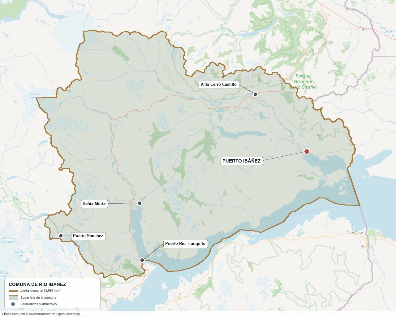
Commune boundary according to OpenStreetMap open data
§ 03 Location, Geography and Territory View
Where Río Ibáñez is, what it is built on and why its soil matters.
3.1 Location
The commune borders Coyhaique to the north, Aysén to the west, Chile Chico to the south and Argentina (Santa Cruz Province) to the east. Puerto Ibáñez is about 110-116 kilometers from Coyhaique, depending on the source, via Route 7 and the junction to the lake shore; Puerto Río Tranquilo, the southernmost locality on the Carretera Austral, is about 220 kilometers away. Villa Cerro Castillo, on Route 7, is about 90 minutes by bus from Coyhaique.
Puerto Ibáñez · 46°17′ S 71°56′ W
3.2 Terrain and setting
Río Ibáñez is the eastern slope of the Patagonian Andes. Around 90% of the terrain bears traces of glacial erosion, and in the northwest there are active ice fields. The peaks cited by the municipal climate change plan are Cerro Castillo (2,318 m), Farellón (2,400 m) and Pirámide (1,743 m); the Hudson volcano (2,600 m) and Monte San Valentín (4,056 m, the highest peak in Patagonia) lie on the boundaries with other communes, not within it. The towns are all at low elevation: the lake shore sits at around 200 meters.
The geology divides into three bands: metamorphic rocks in the southwest (hence the marble of the Capillas), sedimentary rocks in the depressions, and volcanic rocks in the center and east, linked to the Hudson. The Liquiñe-Ofqui fault controls the valleys where the lake sits.
3.3 Hydrography
Main bodies of water in the commune5 rows
| Watercourse | Role in the territory |
|---|---|
| Lago General Carrera (Chelenko) | 1,848 km² in total, of which about 970 km² are Chilean. It is the largest lake in Chile and is shared with Argentina (where it is called Buenos Aires). Its maximum depth is around 586-590 m, according to secondary sources. |
| Río Ibáñez | 88 km from the Hudson glaciers to the lake; it forms the Salto Río Ibáñez and irrigates the Puerto Ibáñez valley. It swells with the winter rains. |
| Río Murta | 88 km from the Cordillera Castillo to Bahía Murta; its floods forced the town to be moved. |
| Ríos Avellano, Tranquilo and Leones | They flow into the lake from the north and the east; they feed the valleys used for summer-pasture livestock farming. |
| Lagos Lapparent, Verde, Alto and Las Ardillas | High-elevation lakes, suitable for sport fishing; several of the properties around them are reached by water or on foot. |
3.4 Soils
The soils are thin and poorly developed: over 60% of the commune is classified in classes VI to VIII, that is, with no agricultural suitability. Fluvisols and mallines (wet meadows) make up barely 1.5% of the territory, but they are what sustain summer livestock farming. Only a few points near the lake, such as Puerto Ibáñez and Bahía Jara, reach class III, suitable for vegetables and minor fruit trees.
- Advantage: the microclimate of the lakeshore allows gardens and fruit trees in the east.
- Limitation: good agricultural soil is scarce, concentrated in the narrow valleys next to the water.
- Risk: the rains from May to September (over 60 mm a month) increase the risk of mudslides and landslides that cut roads and power.
- Real estate implication: the value of rural land does not rest on agriculture; it is sustained by the landscape, access and tourism.
§ 04 Climate and Seasonality View
Two climates in one commune: a rainy, cold west and a dry, windy east that the lake moderates.
There is no Dirección Meteorológica station with a climate normal within the commune. The INIA station in Puerto Ibáñez has been recording since 2019, a period too short to establish averages, so the figures below are modeled averages for the whole commune (ARClim, 1991-2020) and municipal data by sector. The communal climate change plan classifies the west as temperate rainy and the east as a continental arid-cold regime.
Reference climate parameters7 rows
| Parameter | Typical value | Comment |
|---|---|---|
| Annual precipitation (commune-wide average) | 1,386 mm | Includes peaks and ice fields; in the eastern towns it rains much less. |
| Precipitation in the west (Murta, Río Tranquilo) | ≈ 1,500 mm | Municipal data; it is the wettest sector. |
| Mean annual temperature (commune-wide) | 4.9 °C | Average for the whole commune: it underestimates that of the towns, which lie at low elevation. |
| Temperatures in the west | 13.1 °C in January · 4.8 °C in July | Minimums of down to −4 °C in winter. |
| Frost days per year (commune-wide) | 181 | The lake reduces frosts along the shore. |
| Nearby analog: Balmaceda | 523 mm · 7.1 °C | DMC station in Coyhaique, 1991-2020 normal; only as a reference for a steppe climate. |
| Analog on the same lake: Chile Chico | 296 mm · 11.3 °C | 1970-2000 normal; gives an idea of the drier, warmer southern shore. |
The municipal projection (scenario SSP2-8.5, 2041-2070) points to a somewhat warmer climate (from 4.9 to 6.1 °C commune-wide average), with 4.7% less precipitation and 42% less accumulated snow, and with dry spells of 20 days or more rising from 3.3 to 7.2 per year. In a commune where rural water intakes depend on surface sources, drought —there were already water emergencies in 2008, 2016 and 2022— is the climate risk that most affects anyone buying a rural property.
§ 05 History: A Hundred Years of Settlement on a Timeline View
A commune settled by colonists who arrived in a territory without roads, supplied for decades from Argentina and marked by a volcano.
-
Thousands of years
Hunter-gatherers
The peoples who inhabited the area left rock paintings in Villa Cerro Castillo (Paredón de Las Manos, Las Grecas, La Guanaca con Cría). The Consejo de Monumentos Nacionales dates them between 3,000 and 6,000 years old; the PLADECO speaks of "more than 10 thousand."
-
1905
The first settlers arrive
Families from Regions VIII, IX and X settle in the Ibáñez valley; there are also Argentine settlers drawn by the agricultural microclimate. With no road to Coyhaique, supplies come from Argentina, crossing by ox and on horseback.
-
1924
Founding of Puerto Ibáñez
The town is officially founded in 1924, according to the municipal culture plan (other sources say 1921). In 1928 its first Carabineros post is set up, with two officers.
-
1947 – 1955
Health post, road and first school
In 1947 the health post arrives; in 1952, a gravel road to Coyhaique (by ox cart the trip could take up to a month); in 1955 the residents themselves build the first school.
-
1950
Copper in Puerto Sánchez
Copper is discovered in the area and the "Eulogio Sánchez" camp and shipping port is born, in memory of the company's president. Unlike Río Tranquilo, which has livestock-farming origins, Puerto Sánchez is a mining town.
-
1955
Founding of Puerto Río Tranquilo
It begins as a livestock and agricultural colonization town, with sawmills in Murta and Tranquilo and mining operations at Puerto Cristal and Las Chivas.
-
1966
Founding of Villa Cerro Castillo
It is founded at the foot of the mountain that gives it its name, on the route south.
-
1976
Ceramics in Ibáñez River clay
Clay craftsmanship takes hold in Puerto Ibáñez, with techniques brought from Temuco.
-
1980
The commune is created
The PLADECO records the creation of the commune on June 5, 1980 by DL 2,868; the municipality is installed on June 20, 1981. It had previously been a subdelegation (1959) and, since 1975, part of General Carrera Province.
-
1991
Eruption of the Hudson volcano
On August 8 the Hudson erupts, with ash deposits of 0.45 to 1.20 meters in the nearby valley. Sheep farming was the hardest hit and properties in the upper Ibáñez valley were abandoned. The commune's population fell from 3,736 (1982) to 2,772 (1992), though with other possible causes, such as the end of mining.
-
1987 – 1997
The Puerto Cristal mine closes
The Puerto Cristal mining camp, for lead, zinc and copper, stops operating between the late 1980s and the 1990s (sources give 1987 or 1997). In 2008 it was declared a Historic Monument.
-
1994
Marble Chapels Sanctuary
Decree 281 of 1994 declares the Capillas de Mármol (Marble Chapels) a Nature Sanctuary, today the lake's main attraction.
-
2008
Two historic monuments
The Old School of Cerro Castillo and the Puerto Cristal Mining Camp receive the Historic Monument designation.
-
2018
Cerro Castillo National Park and ZOIT Chelenko
The former reserve is recategorized as a national park (CONAF cites decree 8 of 2018; the agreement with Tompkins Conservation was signed in 2017) and the ZOIT of Lago General Carrera is updated as "Chelenko."
-
2025 – 2026
Green List and new works
In September 2025 Cerro Castillo becomes the first national park in Chile on the IUCN Green List. In August 2026 the paving of 16.2 km of Route 7 between Bahía Murta and the Puente El Belga begins.
§ 06 Cultural Identity and Indigenous Peoples View
Almost a third of the inhabitants identify with an Indigenous people, more than in the region and almost triple the national share.
According to the 2024 Census, 882 people (32.4%) declare belonging to an Indigenous people, compared with 29.0% in the region and 11.4% nationally. In the 2017 Census 29.85% declared themselves Indigenous and the Mapuche people were the majority (27.6%, versus 14.65% in 2002). Among the first settler families, Mapuche surnames abound, such as Inayao, Hueitra, Paichil, Antrilao, Millacura and Millaldeo.
The cultural layers of Río Ibáñez4 rows
| Tier | Visible traces today |
|---|---|
| Hunter-gatherers | Rock paintings of Villa Cerro Castillo; the Indigenous name of the lake, Chelenko. |
| Chilean and Argentine settlers | Founding of the towns from 1905; rural life, the rodeo, the jineteada and the Fiesta del Chivo (Goat Festival). |
| Miners | The Puerto Cristal camp and the town of Puerto Sánchez; the Fiesta del Minero (Miners' Festival) and the Apialadas. |
| Mapuche roots | Surnames of the pioneer families, weaving, silverwork and clay ceramics of Puerto Ibáñez with Tehuelche symbols. |
The mix shows in the local festivals: the jineteada and the rodeo, the Fiesta del Chivo, the Fiesta del Arreo of Bahía Murta, which coincides with the moving of animals to summer pasture, and the Wetripantu, the Mapuche new year, which Bahía Murta celebrates together with the Fiesta de la Papa with the Manquekura Indigenous association.
§ 07 Key Demographic Data View
7.1 Population and growth
Comparative demographic indicators11 rows
| Indicator | Commune | Region | Country |
|---|---|---|---|
| Population, 2017 Census | 2,666 | — | 17,574,003 |
| Population, 2024 Census | 2,723 | — | 18,480,432 |
| Intercensal change | +2.1 % | −2.3 % | +5.2 % |
| Commune area | 5,997 km² | — | — |
| Population density (2024) | 0.45 inhab./km² | — | — |
| Foreign-born population | 3.8 % | 3.9 % | 8.7 % |
| Sex ratio 2024 | 107.4 | 97.9 | 94.3 |
| Demographic Dependency Ratio (IDD) 2024 | 51.8 | 46.3 | 46.5 |
| Elderly Index (IAM) 2024 | 121.2 | 66.2 | 79.0 |
| Average schooling | 9.3 years | 9.9 years | 10.4 years |
| Rural population | 100 % | 23.0 % | 13.3 % |
7.2 Age structure (2024 Census)
Population distribution by age group5 rows
| Age group | Population 2024 | % Commune |
|---|---|---|
| 0 – 14 years | 420 | 15.4 % |
| 15 – 29 years | 412 | 15.1 % |
| 30 – 44 years | 640 | 23.5 % |
| 45 – 64 years | 742 | 27.2 % |
| 65 years and over | 509 | 18.7 % |
The commune is growing (+2.1%) while the region loses population (−2.3%), but it is growing older: the elderly index rose from 84.6 in 2017 to 121.2 in 2024, and there are more men than women (sex ratio 107.4). The commune's population remains smaller than in 1982, when it reached 3,736 inhabitants.
It is a commune without a city: not even Puerto Ibáñez, with 764 inhabitants in the 2017 Census, exceeds the urban threshold. Three localities concentrate almost everything: Puerto Ibáñez, Puerto Río Tranquilo and Villa Cerro Castillo. The floating population of tourists and seasonal workers does not appear in the Census but, according to the PLADECO, explains part of Río Tranquilo's growth.
§ 08 Economic and Socioeconomic Data View
8.1 Poverty and social indicators
Social indicators compared6 rows
| Indicator | Commune | Region | Country |
|---|---|---|---|
| Income poverty, Casen 2024 | 22.1 % | 14.3 % | 17.3 % |
| Multidimensional poverty, Casen 2024 | 15.3 % | 12.1 % | 17.7 % |
| People in households lacking basic services (RSH, Jun. 2026) | 14.0 % | 12.4 % | 12.9 % |
| Overcrowded households (RSH, Jun. 2026) | 4.7 % | 5.7 % | 7.8 % |
| Indigenous population (2024 Census) | 32.4 % | 29.0 % | 11.4 % |
| People with disabilities (aged 5 or over, 2024 Census) | 13.1 % | 10.8 % | 11.1 % |
Income poverty is higher than the regional rate (22.1% versus 14.3%), although the Casen 2024 methodology changed and is not comparable with 2022. Multidimensional poverty, by contrast, is lower than the national rate: what is lacking is income more than housing or education. Overcrowding is low, but 14% of people live in households without complete basic services, a sign of dispersed rural homes with no water or sewer network.
8.2 Economic activity (SII) and municipal finances (SINIM)
Business structure and municipal finances12 rows
| Economic indicator (SII / SINIM) | Value |
|---|---|
| Businesses (SII 2024) | 628 (558 in 2022; 581 in 2023): 437 micro, 52 small, 1 medium-sized, 138 with no sales |
| Accommodation and food service businesses | 153 (131 in 2022) |
| Retail and trade businesses | 116 |
| Agriculture, livestock, forestry and fishing businesses | 79 (86 in 2022) |
| Administrative services businesses | 81 |
| Reported salaried employees | 396 in 2024 (640 in 2022) |
| Workers in accommodation and food service | 122 |
| Workers in agriculture and livestock | 40 |
| Total municipal revenue (SINIM 2025) | $6,253 million |
| Fondo Común Municipal (Municipal Common Fund) (2025) | $3,261 million, 52.2% of revenue |
| Permanent own-source revenue (2025) | $506 million, 8.1% of revenue |
| Property tax · vehicle circulation permits · business licenses (2025) | $129 · $114 · $58 million |
The business structure is that of a tourism-services commune: the largest sector by number of businesses is accommodation and food (153), ahead of trade (116), and agriculture comes third despite having 79 businesses, because almost all are family holdings with no contracted workers (40 salaried employees). In municipal finances, 52% of revenue comes from the Fondo Común Municipal and only 8% is own-source revenue: the municipality depends on transfers, something the municipality's own public accountability report acknowledges.
§ 09 The Economic Engine: Tourism, Public Spending and Extensive Livestock Farming View
Why Río Ibáñez's economy explains how a half-hectare parcel can cost ten times more per hectare than a large ranch.
9.1 Tourism: the visible engine
Tourism groups the most businesses (153 in accommodation and food in 2024, 24% of the total) and almost 22% of salaried employment (126 workers in 2023). It rests on three pillars: Cerro Castillo National Park and its trekking, the Marble Chapels, visited by boat from Puerto Río Tranquilo, and the Carretera Austral that connects the two. Boating and kayak companies registered for the Chapels rose from 3 in 2011 to at least 33 in 2023, according to the municipal community action plan.
Visitors registered at Cerro Castillo National Park (CONAF)6 rows
| Year | Visitors | Remarks |
|---|---|---|
| 2012 | 1,575 | First available record. |
| 2016 | 5,149 | First jump in the series. |
| 2019 | 13,350 | 8,673 Chileans and 4,677 foreigners. |
| 2020 | 7,017 | Pandemic. |
| 2023 | 11,239 | — |
| 2024 | 13,907 | 7,772 Chileans and 6,135 foreigners; this is the series maximum. |
The numbers understate reality: they count only those who register at the CONAF entrances, not those who enter through other points or simply pass through Villa Cerro Castillo. Even so, they show a park that barely existed on the map a decade ago and that in September 2025 became the first national park in Chile on the IUCN Green List. In 2026, moreover, CONAF restricted trekking: Las Horquetas (53.5 km, 3 to 5 days) opens only with a certified guide, and Estero Parada has been closed to self-guided hiking since May 29; the trails close between May and September. For local operators that means captive clients; for independent travelers, a more expensive trek.
9.2 Extensive livestock farming: sheep, goats and cattle
The latest commune-level agricultural data that could be verified is the 2007 Census, cited in the PLADECO: 342 holdings, 17,031 cattle, 21,473 sheep and 5,690 goats. Río Ibáñez's goats were 46% of those of the entire region, an unusual figure that explains the Fiesta del Chivo and the sanitary treatments the municipality gave in 2024 to 5,116 animals (3,497 sheep, 1,551 goats, 35 horses and 33 cattle). The PLADECO describes extensive livestock farming on natural pastures, with smaller herds per producer than the regional average, and a "very limited" agriculture concentrated in the narrow valleys beside the lake.
Since 2007 the region lost about a third of its cattle (−33.9%) and its sheep (−36.5%) through the 2021 Census. The 2021 commune-level table could not be found, so it cannot be stated how much Río Ibáñez's livestock declined; only that the economic floor that livestock farming provided is lower than the one shown by the 2007 census.
9.3 Other economic pillars
- Public spending: public administration was the largest salaried employer in 2023 (211 of 575 workers, 36.7%) and the municipality receives more than half of its revenue from the Fondo Común Municipal. In 2024 the SII records barely 56 workers in that category: the change is unexplained.
- Lakeshore fruit growing: the cherry hub of Aysén is Chile Chico (about 190 ha of cherry orchards), not Puerto Ibáñez. Puerto Ibáñez has gardens and fruit trees thanks to its microclimate, but the commune's fruit-growing area could not be verified.
- Construction: 24 businesses, but barely 7 salaried workers in 2023 (57 in 2021): it depends on occasional public works, such as the 16.2 km of paving on Route 7 between Bahía Murta and the Puente El Belga that the MOP began in August 2026.
- Mining: there are no active operations in the commune today (2 businesses and 0 workers in the SII). What remains is the legacy of Puerto Cristal, with tailings that a Sernageomin study funded by the Regional Government (2018) links to lead and zinc in the lake. Cerro Bayo is not in Río Ibáñez: its ore left through the port of Puerto Ibáñez.
- Energy and aquaculture: no hydroelectric, mining or aquaculture project under review was identified within the commune; the nearest ones are in Chile Chico and in the commune of Aysén.
§ 10 Real Estate Market View
10.1 Available properties and property types
It is a market of land, not houses. As of November 2, 2026 there were 70 unique properties for sale on Yapo and ChilePropiedades (duplicates were removed: a single property can appear up to six times). The supply of houses is almost nil (two listings on Yapo, none on ChilePropiedades). Mercado Libre requires registration and Portal Inmobiliario blocks queries, so those portals could not be reviewed.
The properties are concentrated in three zones: the surroundings of Villa Cerro Castillo (29 properties, with subdivisions of half-hectare parcels and large native-forest ranches), Puerto Ibáñez and the Península Levicán (20 properties, with lakeside parcels and livestock estates) and Bahía Murta with the Murta-Tranquilo corridor and El Avellano (16 properties). Puerto Sánchez has 4 listings and Puerto Río Tranquilo just one, with a house. Produncan markets two ranches within the commune: Campo El Rocoso (50 ha) and Campo Reserva Alto Río Ibáñez (297 ha); the price per hectare of both falls within the range observed in the market for properties of that size.
10.2 Price by property size (indicative, November 2026)
Median price per hectare by size (asking prices, 70 unique properties)6 rows
| Property size | Properties | Median per hectare | Range per hectare |
|---|---|---|---|
| Under 1 ha (0.5 ha parcels) | 20 | $82.4 million (UF 1,998) | $16 to $170 million |
| 1 to 3 ha | 10 | $41.0 million (UF 994) | $8 to $87 million |
| 3 to 10 ha | 4 | $29.6 million (UF 716) | $10 to $52 million |
| 10 to 50 ha | 10 | $11.1 million (UF 269) | $1.5 to $67 million |
| 50 to 200 ha | 12 | $4.4 million (UF 107) | $1.2 to $10.4 million |
| Over 200 ha | 14 | $2.5 million (UF 62) | $0.7 to $7.4 million |
The price per hectare falls about 33 times between half-hectare parcels and ranches of over 200 ha: an almost continuous volume discount. For a 5,000 m² parcel, the total price is what matters: the median is $38.7 million in Villa Cerro Castillo (10 properties), $16 million in Puerto Ibáñez and Península Levicán (6 properties) and $38.7 million in Bahía Murta (2). Puerto Sánchez and Puerto Río Tranquilo have a sample of a single property each, so no medians are calculated.
Price by locality, parcels up to one hectare and ranches of 50 ha or more5 rows
| Locality | Properties | Parcels up to 1 ha | Ranches of 50 ha or more |
|---|---|---|---|
| Villa Cerro Castillo and surroundings | 29 | 10 listings; ≈ $42 million per 5,000 m² (range $12 to $72 million) | 13 listings; median $2.8 million/ha |
| Puerto Ibáñez, Levicán and Alto Río Ibáñez | 20 | 6 listings; 5,000 m² parcel at $8 to $20 million | 6 listings; median $4.3 million/ha |
| Bahía Murta (Murta-Tranquilo, El Avellano) | 16 | 2 listings; $30 million parcel | 7 listings; median $3.0 million/ha |
| Puerto Sánchez | 4 | 1 listing: 6,500 m² in Bahía La Porfía, UF 2,343 | No listings |
| Puerto Río Tranquilo | 1 | 1 listing: 0.5 ha with a 72 m² house, $85 million | No listings |
These are asking prices, not closing prices. Several properties show visible price cuts: a 347 ha native-forest ranch went from UF 8,100 in 2024 to $260 million in 2026; another of 240 ha, from UF 11,560 to UF 9,000. Of the 70 properties, 37 were posted in 2026 and 33 date from 2023 to 2025 and have been renewed, a sign of a thin market.
10.3 What the Río Ibáñez prices show
Factors that appear in the listings (in no order of impact)5 rows
| Factor | What the listings show | How to check it here |
|---|---|---|
| Property size | Explains most of the variation in price per hectare (see the table above). | Always compare the total price and the $/ha against properties of the same size. |
| Locality | At the same size (0.5 ha), the Villa Cerro Castillo median is double that of Puerto Ibáñez and Levicán: $38.7 versus $16 million. | Small samples (10 and 6 listings): not interpreted as a cause. |
| Subdivision with water and 4G | A Villa Cerro Castillo subdivision with water and coverage asks UF 1,200 (≈ $50 million); parcels without services in Levicán, $8 to $8.5 million. | Ask for the water and electricity feasibility certificate, not the listing's promise. |
| Access | The cheapest ranches have difficult access: 732 ha in Torres del Avellano (boat and 4x4 track) at $0.7 million/ha and 195 ha in Levicán partly reachable only on foot, at $1.2 million/ha. | Verify that the easement is registered with the Conservador before making an offer. |
| Lake or road | The most expensive ranches per hectare have a road or lake frontage and "tourism potential": 125 ha on route X-65 at $10.4 million/ha; 189 ha on Lago Lapparent at $8.5 million/ha, with access only by water. | Request an independent valuation report; the list price is not a closing price. |
§ 11 Land-Use Planning: a Commune without a Zoning Plan View
Río Ibáñez has no communal or intercommunal zoning plan, and that defines what can be done with a property.
The BCN Communal Report (2025) records that the commune has no Communal Zoning Plan in force, and the PLADECO 2018-2026 adds that it also has no Intercommunal Zoning Plan with Chile Chico, which it attributes to "the lack of planning, enforcement capacity and urban ordinances." Pursuing such a plan is listed as a PLADECO initiative; its status in 2026 could not be verified. The urban limits of Puerto Ibáñez, Villa Cerro Castillo, Bahía Murta and Puerto Río Tranquilo could not be verified either. In practice, the entire commune is governed by rural regulations.
Planning instruments and status5 rows
| Instrument | Status | What it means for a property |
|---|---|---|
| Communal Zoning Plan (PRC) | Does not exist (BCN 2025) | No zoning or uses by zone; there is no official map of risk zones. |
| Intercommunal Zoning Plan | Does not exist (PLADECO) | No joint rules with Chile Chico. |
| PLADECO 2018-2026 | Approved on April 23, 2019; in its final year | Guidance, not regulation. A subsequent plan could not be verified. |
| ZOIT Chelenko | Decree 4 of 2018; extended until July 14, 2030 (DEXE 141 of 2026) | Prioritizes public investment in tourism; the decree itself clarifies that it grants no environmental protection status and does not restrict uses. |
| Rural subdivision | DL 3,516 and Res. Ex. 334/2022 of the Seremi MINVU Aysén | Lots from 0.5 ha with an SAG certificate; prior report from the Seremi if the purpose is not agricultural. |
The Seremi de Vivienda de Aysén (Res. Ex. 334 of 2022) set criteria for those reports: proximity to the urban limit of colonization localities with feasible services, access to a public road, compatibility with areas of natural or heritage value, and that the project not be located in a risk area. The 2026 listings reflect this: "subdivision plan approved by the SAG and registered with the CBR of Coyhaique."
Protected areas and designations affecting properties in the commune5 rows
| Area | Designation | For the buyer |
|---|---|---|
| Cerro Castillo National Park | 143,502 ha between Coyhaique and Río Ibáñez; CONAF; IUCN Green List 2025 | There are private properties with livestock inside the park: check boundaries. The area within the commune could not be verified. |
| Laguna San Rafael National Park | 1,742,000 ha; CONAF | Entry point at Puerto Río Tranquilo, but the road to Bahía Exploradores and the glacier are in the commune of Aysén. |
| Marble Chapels Nature Sanctuary | ≈ 50 ha, decree 281 of 1994 | Expansion to 1,131 ha proposed in 2017 and not carried out; sources disagree on whether the sanctuary is in Río Ibáñez or in Chile Chico. |
| Torres del Avellano Protected National Property | About 102,000 ha awaiting designation since 2021 | Several ranches of 130 to 730 ha on the market are in its vicinity. |
| National monuments | Paredón de Las Manos, Old School of Cerro Castillo, Puerto Cristal Mining Camp | Works in their surroundings require authorization from the Consejo de Monumentos Nacionales. |
Natural hazards are described by the PLADECO: the Hudson volcano, west of the commune, with a "medium" risk of pyroclastic fall, and, from May to September, rains of more than 60 mm a month that raise the risk of mudslides, landslides and falling trees, with road and power cuts. In 2016 there was a red alert for a wildfire in the commune, and the Cerro Castillo Park management plan rates fires as its main threat. Since there is no zoning plan, none of these hazards is declared in an instrument: the buyer must request the risk study.
§ 12 Towns and Sectors View
Río Ibáñez has no neighborhoods because it has no city. It has five towns separated by dozens of kilometers and several scattered rural sectors (El Claro, Península Levicán, Palavicini, El Manso, Lago Lapparent, El Avellano, Las Ardillas, Bajada Ibáñez, Lago Tranquilo and Puerto Cristal). Each town has its anniversary, its school and its health post.
Localities of the commune and their profile5 rows
| Locality | Features | Market profile |
|---|---|---|
| Puerto Ibáñez (764 inhab.) | Commune capital; ferry port to Chile Chico; dry microclimate with gardens and fruit trees; health post, landfill and municipal seat; its own power generation. | Parcels of $8 to $20 million per 5,000 m² in Levicán; livestock estates of 100 to 400 ha. |
| Villa Cerro Castillo (376) | On Route 7 and gateway to the national park; technical high school; Historic Monument Old School; bus terminal in design. | Half-hectare subdivisions with water and 4G, at $12 to $72 million; native-forest ranches. |
| Puerto Río Tranquilo (458) | Departure point for the Marble Chapels and the road to Exploradores; the locality with the most tourism pressure and sanitation problems; bus terminal under construction (≈ $3,600 million). | Very little supply: one listing in 2026 (0.5 ha with a house, $85 million). |
| Bahía Murta (212) | Town on the Murta River, with a school and boarding facility; high historical risk of mudslides; the stretch of Route 7 to the south has been under paving since 2026. | Parcels of $30 million; ranches of 36 to 920 ha, at $1.5 to $7.8 million per hectare. |
| Puerto Sánchez (46) | Former mining port, access to the Marble Caverns; municipal delegation since 2026. | Four listings: from $32 million (1 ha) to $420 million (12 ha); a 6,500 m² parcel in Bahía La Porfía at UF 2,343. |
§ 13 Basic Services, Utilities and Digital Connectivity View
In a commune of 0.45 inhabitants per square kilometer, having a service at the edge of a property is not the norm but the exception.
Service providers and coverage6 rows
| Service | Provider / operator | Practical notes |
|---|---|---|
| Electricity | Edelaysén (Saesa group) | Puerto Ibáñez has its own "island" generation: on October 1, 2025 it regained power quickly after a blackout that affected 28,000 customers in Coyhaique, Aysén and Río Ibáñez. Scattered sectors use individual solar panels (e.g., 25 families in Lago Alto and Río Sin Nombre). |
| Rural drinking water | Rural drinking water committees | The La Bajada committee is on record. Many rural homes have a well or a private solution: in 2024 the municipality funded improvements for 13 homes in Levicán, El Bosque, El Cacique, La Bajada, Puerto Ibáñez and La Balsa. |
| Sewerage | Local treatment plants | The PLADECO states that they cover 95% of the "urban sectors"; the one in Puerto Río Tranquilo is inefficient in the rain and in summer. Coverage by locality: not verified. |
| Gas and heating | Firewood and LPG | No verified commune-level data. |
| Internet and phone | Fibra Óptica Austral | Access points in Puerto Ibáñez, Villa Cerro Castillo and Puerto Río Tranquilo. Official mobile coverage by operator could not be verified; there are only indications that Entel covers Río Tranquilo. |
| Waste collection | Municipality | Landfill in Puerto Ibáñez; Villa Cerro Castillo takes its waste there; the Puerto Río Tranquilo dump has still not been closed. |
§ 14 Health View
The commune has no Cesfam (family health center) or hospital: all care is handled at rural health posts and medical rounds, and a major emergency requires travel.
Rural health depends directly on the Servicio de Salud Aysén, not on the municipality. The DEIS records five facilities in the commune, all Postas de Salud Rural (Rural Health Posts) (July 2026). The PLADECO proposes a Family Health Post for Puerto Ibáñez, a new post for Bahía Murta and one for Cerro Castillo, and agreements to transfer patients to Coyhaique and Valdivia.
Health network of the commune5 rows
| Facility | Type | Detail |
|---|---|---|
| Puerto Ibáñez health post | Rural health post | With a doctor, midwife and paramedics; its own ultrasound and ambulance (Minsal notes, dated). |
| Puerto Río Tranquilo health post | Rural health post | With medical rounds and ultrasound. |
| Bahía Murta health post | Rural health post | A replacement was approved in 2016 (≈ $665 million); its current status could not be verified. |
| Villa Cerro Castillo health post | Rural health post | New post in the PLADECO works plan. |
| Puerto Sánchez health post | Rural health post | Maintenance works in 2024. |
The frequency of medical rounds per post could not be verified. Nor should the "enrolled population" reported by the BCN (131 people) be used: it does not match the 2,723 inhabitants, probably because most are registered at another facility in the network.
§ 15 Education View
15.1 School education
The commune has five schools, all public: they were municipal until 2023 and since 2025 have depended on the Servicio Local de Educación. Enrollment fell from 354 students in 2023 to 341 in 2025: 51 in early childhood education, 227 in primary, 40 in scientific-humanistic secondary and 23 in technical-vocational secondary.
Schools of the commune5 rows
| Facility | Locality | Distinction |
|---|---|---|
| Escuela Aonikenk | Puerto Ibáñez | School of the commune capital; the town has the Adriana Riquelme library. |
| Escuela Carretera Austral | Bahía Murta | With boarding facility; maintenance of 1,719 m² for $408 million in 2024. |
| Escuela Gabriela Mistral | Puerto Río Tranquilo | School of the commune's most touristic locality. |
| Escuela María Antonieta Parra | Puerto Sánchez | 36.3 m² extension in 2024. |
| Liceo y escuela de Villa Cerro Castillo | Villa Cerro Castillo | Technical high school with secondary education; Pequeños Caminantes kindergarten. |
SIMCE 2025 results (preliminary, commune / region / country)7 rows
| SIMCE test | Commune | Region | Country |
|---|---|---|---|
| 4° básico (Grade 4), Reading | 273 | 276 | 276 |
| 4° básico (Grade 4), Mathematics | 244 | 257 | 262 |
| 8° básico (Grade 8), Reading | 230 | 229 | 238 |
| 8° básico (Grade 8), Mathematics | 247 | 252 | 258 |
| 8° básico (Grade 8), History | 250 | 245 | 250 |
| 2° medio (Grade 10), Reading | 248 | 246 | 250 |
| 2° medio (Grade 10), Mathematics | 248 | 261 | 263 |
Scores are below the region and the country in mathematics at all three levels and in reading at 4° básico; in 8° básico reading and history they are above the region. With classes of 10 or 15 students, averages vary widely from year to year and are preliminary, so they are best read as a trend rather than a diagnosis.
15.2 Higher education
No higher education campus was identified within the commune. Anyone who wants to study after secondary school must go to Coyhaique or another city, which adds to the low average schooling (9.3 years, versus 10.4 nationally) and to the youth out-migration mentioned by the PLADECO.
§ 16 Lake, Mountains and Natural Surroundings View
Río Ibáñez is the gateway to three landscapes that are rarely seen together anywhere else in Chile: Lago General Carrera, the largest in the country; the Cerro Castillo mountain range, with its rock spires above the lenga forest; and the edge of the Campo de Hielo Norte (Northern Patagonian Ice Field), from which glaciers descend into the western valleys.
Natural attractions of the commune7 rows
| Attraction | Where it is | Activities |
|---|---|---|
| Cerro Castillo National Park | Entrance at Villa Cerro Castillo; the park is shared with the commune of Coyhaique | 3- to 5-day trekking (now only with a certified guide), short hikes to Laguna Chiguay, photography, wildlife watching. |
| Marble Chapels | On the lake, about 6 km from Puerto Río Tranquilo | 1.5-hour boat tour (about $25,000 per person, online agency price, 2026) and kayaking. |
| Exploradores Glacier | Laguna San Rafael National Park, about 52 km of gravel road from Puerto Río Tranquilo (the sector is in the commune of Aysén) | Guided trekking on the ice; reopened in February 2024 with a new route. |
| Salto Río Ibáñez | On the course of the Ibáñez River, which flows from the Hudson volcano to Puerto Ibáñez | Natural attraction on the river; no verified data on tourism operations. |
| Península Levicán | Northern shore of the lake, south of Puerto Ibáñez | Lake beaches, gardens and livestock estates. |
| Lagos Lapparent, Alto and Las Ardillas | High valleys of the commune | Sport fishing; several of the properties in those valleys are reached by water or on foot. |
| Paredón de Las Manos | About 3 km southwest of Villa Cerro Castillo | Rock paintings; National Monument, protected by law. |
Surroundings of Río Ibáñez: Lago General Carrera, Cerro Castillo and Bahía Murta
The wildlife includes the huemul (South Andean deer), which the IUCN classifies as critically endangered and which Cerro Castillo protects as one of the species' five sanctuaries in Aysén; there are also guanacos, pumas, culpeo foxes, condors and waterbirds such as the ashy-headed goose (caiquén) and the kingfisher. The park preserves deciduous lenga forest, evergreen Magellan coigüe forests and steppe toward the border. Laguna Chiguay is home to the vulnerable amphibian Atelognathus salai, so access to its shore is prohibited.
§ 17 Connectivity and Transportation View
17.1 Road network
Route 7 (Carretera Austral) crosses the commune from north to south through Villa Cerro Castillo, Bahía Murta and Puerto Río Tranquilo. The stretch from Coyhaique to Villa Cerro Castillo and Puerto Ibáñez is paved (about 108 km); to the south the road remains gravel and suffers weather closures, with landslides and mudslides. Route X-65 links Puerto Ibáñez with the Pallavicini pass, on the border with Argentina.
Routes and distances6 rows
| Route / destination | Distance and details |
|---|---|
| Coyhaique – Villa Cerro Castillo | Paved; about 90 minutes by bus. |
| Coyhaique – Puerto Ibáñez | 108 to 116 km depending on the source; about 1 h 45 min by bus. |
| Coyhaique – Puerto Río Tranquilo | About 220 km; 4 to 5 hours by car and more than 5 by bus. |
| Villa Cerro Castillo – Bahía Murta – Puerto Río Tranquilo | Gravel, with 16.2 km of Route 7 under paving between Bahía Murta and the Puente El Belga since August 2026. |
| Puerto Río Tranquilo – Cochrane | About 115 km of gravel. |
| Puerto Ibáñez – Chile Chico | By ferry, about 2 hours; through Argentina, about 7 hours with customs procedures. |
Río Ibáñez between Coyhaique, Chile Chico and Cochrane
17.2 The Lago General Carrera ferry
Puerto Ibáñez is the port of the ferry linking the Carretera Austral with Chile Chico, and it is the shortest connection to Argentina and to the south shore of the lake. About 111,000 people, 21,000 cars and 3,000 trucks passed through in 2025. The subsidized concession has been held by Naviera Austral since July 2025, with the ferry La Tehuelche; when it went into maintenance, the Ministry of Transport put La Chelenco in service with three daily trips from October 19 to 31, 2026.
Puerto Ibáñez – Chile Chico ferry fact sheet (2026 data; confirm with the operator)6 rows
| Fact | Detail |
|---|---|
| Duration | About 2 hours. |
| Fares | Passenger $2,510; vehicle up to 5 m, $21,270 (without driver). Secondary source: a private guide. |
| Schedules, low season 2026 | Several departures per week in each direction; the schedule changes in high season and with vessel maintenance. |
| Reservations | At ventas.navieraustral.cl or at the terminals in Coyhaique, Puerto Ibáñez and Chile Chico; it fills up on Fridays, Sundays and Mondays. |
| New ferry | Diesel-electric, about 80 m, 300 passengers and 44 light vehicles, for about $24 billion; the Contraloría took note of the contract in March 2026. Delivery date: not verified. |
| Hazardous cargo | Transported only some days of the week. |
17.3 Land transport
- Subsidized bus Puerto Río Tranquilo – Coyhaique: since June 2025, with stops at Cruce Murta and Villa Cerro Castillo. Three trips a week in high season and two in low; $8,000 for the full journey.
- Intercity buses: there are services from Villa Cerro Castillo and Puerto Río Tranquilo to Cochrane (around $17,400 and $11,000, according to an aggregator); current schedules could not be verified.
- Bus terminals: the one in Puerto Río Tranquilo has had its land handed over (about $3,600 million) and the one in Villa Cerro Castillo is in design.
- Airfields: none could be verified within the commune; the reference airport is Balmaceda, in Coyhaique.
§ 18 Tourism: Development, Attractions and Things to Do View
18.1 Tourism development
The commune is part of the ZOIT Chelenko, recognized as a tourist interest zone since 2000, updated in 2018 and extended until 2030. Villa Cerro Castillo also has its own PLADETUR, was recognized in 2022 as one of the "Top 100 Green Destinations," and since August 2023 has a municipal ordinance to manage visits; the park has a single concessionaire.
Seasonality is very high. The INE's 2013 Tourism Demand Survey, cited by the ZOIT documents, showed that 72% of tourists were Chilean (58% from the Región Metropolitana) and 28% foreign, mostly Argentine, with peak demand in January and February. It is an old figure, but the seasonality is confirmed in 2026: the park's trails close from May to September, and a third-party estimate (unofficial) of short-stay rentals in the commune puts average occupancy at only 13%.
18.2 Tourist attractions in the commune
- Cerro Castillo National Park: 143,502 ha, huemul, multi-day trekking and IUCN Green List (2025).
- Marble Chapels: a nature sanctuary of about 50 ha, with caverns and chapels carved by water into the marble. Kayaks and boats depart from Puerto Río Tranquilo and Puerto Sánchez.
- Exploradores Glacier: 20 km long and 95 km², in Laguna San Rafael Park; reached from Puerto Río Tranquilo.
- Paredón de Las Manos and Old School of Cerro Castillo: rock paintings and Historic Monument in Villa Cerro Castillo.
- Puerto Cristal: mining camp declared a Historic Monument.
18.3 Museums and culture
- Adriana Riquelme Library: in Puerto Ibáñez.
- Local radio stations: Radio Padre Antonio Ronchi (93.1 FM) and Radio Mirador (102.5 FM), both in Puerto Ibáñez, according to the Wikipedia registry.
- Municipal Culture Plan 2023-2027: identifies the "cultural gardens" of each locality: jineteada and rodeo in Puerto Ibáñez, traditional festivals in Villa Cerro Castillo, mining in Puerto Sánchez.
18.4 Food and dining
Local cuisine comes from what is raised and harvested: lamb and goat meat from the crianceros, potatoes, apples and calafate from the gardens and hills. The festivals are the best showcase.
- Fiesta del Chivo: celebrates goat herding; in the 2007 Census the commune held 46% of the region's goats.
- Fiesta de la Papa: in Bahía Murta, on June 22, together with the Wetripantu and the Manquekura Indigenous association.
- Fiesta del Calafate (Public Accountability Report 2024) and Fiesta de la Manzana of Bahía Murta, tied to the harvest.
- Gastronomic Festival: in Puerto Ibáñez.
18.5 Nature and the outdoors nearby
- Trekking in Cerro Castillo: from Villa Cerro Castillo to Estero Parada, Las Horquetas and Laguna Chiguay; it now requires a certified guide on the long trails.
- Sport fishing: Lagos Lapparent, Alto and Las Ardillas.
- Horseback riding: in Villa Cerro Castillo and surroundings.
- Mountain races: the Patagonia Trail and the Carrera Hi Tech in Villa Cerro Castillo.
18.6 Calendar of events and traditions
Main events of the year (2024 dates, per the Public Accountability Report; confirm each season)8 rows
| Period | Event | Character |
|---|---|---|
| January 22 – 28 | Bahía Murta anniversary | Anniversary celebration. |
| Summer | Puerto Ibáñez Jineteada and Folklore Festival | Rodeo and jineteada with thousands of attendees; the exact month is not confirmed (one source says January). |
| February 5 – 11 | Puerto Ibáñez anniversary | The commune's biggest festival (about $25.6 million in 2024). |
| February 5 – 9 | Puerto Sánchez anniversary | Fiesta del Minero (Miners' Festival) and apialadas. |
| February 21 – 25 | Puerto Río Tranquilo anniversary | Anniversary celebration. |
| June 22 | Wetripantu and Fiesta de la Papa, Bahía Murta | Mapuche new year with the local Indigenous association. |
| September 16 – 18 | Fiestas Patrias (Chilean Independence Day) | Celebration in every locality. |
| November 11 – 17 | Villa Cerro Castillo anniversary | About $18.5 million in 2024. |
§ 19 Everyday Life, Sport and Practical Information View
What you need to know if you will live in Río Ibáñez, not just visit it.
19.1 Sport and identity
- Rodeo and jineteada: the oldest activity in Puerto Ibáñez; Villa Cerro Castillo has its own rodeo club.
- Mountain races: the Patagonia Trail and the Carrera Hi Tech, in Villa Cerro Castillo.
19.2 Shopping and supplies
The SII records 116 trade businesses in the commune, almost all small. For whatever is missing —spare parts, building materials, specialists— the reference city is Coyhaique, about 116 km from Puerto Ibáñez; Chile Chico serves those who cross by ferry. Fuel is a weak point: there is one station in Puerto Río Tranquilo and another unbranded one on the Carretera Austral, and no pump could be verified in Puerto Ibáñez, Villa Cerro Castillo or Bahía Murta. No bank branch has been verified in the commune; guidebooks advise carrying cash.
19.3 Where to handle paperwork
Offices based in Río Ibáñez5 rows
| Office | Address or contact | Remarks |
|---|---|---|
| Municipality of Río Ibáñez | Puerto Ingeniero Ibáñez · rioibanez.cl | Vehicle circulation permits, business licenses and Registro Social de Hogares online; municipal delegation in Puerto Sánchez since 2026. |
| Real Estate Registrar (Conservador de Bienes Raíces) | Has no office in the commune | The listings cite registration with the Conservador in Coyhaique; sales are registered there. |
| SAG | No verified commune office | The subdivision plan is approved at the regional SAG before being registered. |
| Fire department | Quinta Compañía de Puerto Ibáñez | The only one in the commune; it also serves Villa Cerro Castillo. |
| Carabineros (national police) | Puerto Río Tranquilo police post | Coverage in the other localities not verified. |
19.4 Cost of living and practical considerations
- The cost of living could not be compared with commune-level figures; prices depend on logistics: almost everything arrives from Coyhaique, over gravel south of Villa Cerro Castillo or by ferry from Chile Chico.
- The ferry and Route 7 suffer closures due to weather and maintenance: have a plan B for winter.
- Electricity fails in storms (there were prolonged outages in Bahía Murta and Puerto Sánchez in October 2025): a generator or solar panels are a reasonable complement.
§ 20 Territorial Analysis: Strengths, Challenges and Opportunities View
An honest reading of the territory. A sound investment decision also requires knowing what doesn't work.
- A national park with an IUCN Green List seal (2025) that received 13,907 registered visitors in 2024.
- Puerto Ibáñez is the port of the ferry to Chile Chico, which carried about 111,000 people in 2025.
- The population is growing (+2.1% between 2017 and 2024) while the region's is falling (−2.3%).
- Tourism groups 153 accommodation and food service businesses, 17% more than in 2022.
- The ZOIT Chelenko is extended until 2030, and the lakeshore microclimate allows gardens and fruit trees.
- Aging: 121 people over 65 for every 100 under 15 (region: 66) and low schooling (9.3 years).
- Income poverty of 22.1% according to Casen 2024, versus 14.3% in the region.
- Fiscal dependence: 52% of municipal revenue is the Fondo Común and only 8% is own-source revenue.
- No zoning plan, no published urban limits and no official risk map.
- No Cesfam or hospital: 5 rural health posts; a major emergency requires 116 km to Coyhaique.
- Puerto Río Tranquilo concentrates the tourism pressure, with a wastewater plant that is inefficient in rain and in summer.
- Works under way: 16.2 km of paving on Route 7 (since August 2026), the Puerto Río Tranquilo bus terminal (about $3,600 million) and a new $24 billion ferry.
- Cerro Castillo trekking requires a certified guide: demand for local operators and lodgings.
- Fiber optic with access points in Puerto Ibáñez, Villa Cerro Castillo and Puerto Río Tranquilo.
- Levicán parcels at a median of $16 million, versus $38.7 million in Villa Cerro Castillo: a lower entry point for the second-home buyer.
- Hudson volcano ("medium" pyroclastic risk), mudslides from May to September (rains of more than 60 mm a month) and wildfires.
- Droughts: dry spells of 20 days or more could rise from 3.3 to 7.2 per year by 2041-2070.
- Retreating glaciers: the Exploradores front was closed from October 2023 until February 2024; accumulated snow would fall by 42%.
- Thin market: 70 unique properties, list prices with visible cuts and poorly stated areas in the listings.
- Dependence on a single ferry: in October 2026 it had to be replaced by another vessel for maintenance.
Río Ibáñez: Territory, Connectivity and Opportunities
Río Ibáñez is a lake-and-mountain commune where the value of land is set by the landscape and access: a national park with an IUCN seal, a ferry that crosses to Argentina and a Carretera Austral that is being paved in stretches. In return, it asks the buyer to do their own homework: there is no zoning plan, supply is thin, listings are repeated and services do not always reach the property. Those who verify access, easements, water and risk before making an offer will find land at very different prices depending on size and locality.
At Produncan Lands we know this territory and its opportunities. Our work is to connect properties with people looking to invest, live and develop new projects in southern Chile, offering our experience, local knowledge and commercial reach.
We invite you to get to know our properties in Río Ibáñez and across southern Chile, and to entrust Produncan Lands with the sale of your property.
View properties at Produncan Lands§ 22 Sources and Methodology Note View
22.1 Sources consulted
Documents and sources used14 rows
| Scope | Document and year |
|---|---|
| Demographics, economy and finances | Río Ibáñez Communal Report 2026, BCN, with data from INE (2024 Census), Casen 2024, SII 2024, SINIM 2025, MINEDUC and DEIS-MINSAL. |
| Communal planning | PLADECO 2018-2026 of the Municipality of Río Ibáñez, approved in 2019. |
| Climate, soils and hazards | Communal Climate Change Action Plan 2025, Municipality of Río Ibáñez (cites ARClim 1991-2020). |
| History and identity | Municipal Culture Plan 2023-2027, Municipality of Río Ibáñez. |
| Municipal management and festivals | Public Accountability Report 2024, Municipality of Río Ibáñez, April 2025. |
| Tourism and protected areas | Communities Portal Action Plan 2023-2027; ZOIT Chelenko Action Plan 2017, Subsecretaría de Turismo; Cerro Castillo National Park fact sheet, CONAF. |
| ZOIT Chelenko, 2026 extension | Decreto Exento 141 of 2026, Diario Oficial of August 25, 2026. |
| Rural subdivision | Resolución Exenta 334 of 2022 of the Seremi MINVU Aysén. |
| Agriculture and livestock | Aysén Region: April 2026 update, ODEPA; 2007 Agricultural Census cited in the PLADECO. |
| Real estate market | Sale listings captured on November 2, 2026 on Yapo and ChilePropiedades; UF of $41,258.26 according to the SII. |
| Ferry and road works | Radio 45 Sur, October 2026 and March 2026; 24 Horas, August 2026; lake navigation guide (secondary source). |
| Marble Chapels | Decreto exento 281 of 1994 of the Ministry of Education (Nature Sanctuary); El Desconcierto, 2022. |
| Public transportation | Subsidized Puerto Río Tranquilo – Coyhaique service, 2025. |
| Park visitors | Cerro Castillo National Park, CONAF series 2012-2024 (secondary source). |
22.2 Methodology note and data currency
- The data from the 2024 Census, Casen 2024 and SIMCE 2025 are recent or preliminary and may be adjusted; Casen 2024 uses a new methodology and is not comparable with 2022.
- The following could not be verified, and were therefore left out: monthly precipitation and temperature for the towns, hours of electricity supply, official mobile coverage, the frequency of medical rounds, population by locality in 2024, water rights, registered Indigenous lands and the 2021 Agricultural Census at the commune level.
- The sources disagree on some data: the creation of the commune (1959, 1980 or 1981 depending on the document), the founding of Puerto Ibáñez (1921 or 1924), the closing of Puerto Cristal (1987 or 1997) and the commune to which the Marble Chapels belong (the 1994 decree places them in Río Ibáñez; another source, in Chile Chico). Here the source and the discrepancy are indicated.
- Mallín Grande and Puerto Guadal are located in the commune of Chile Chico and are not included. Aysén's cherries are produced mostly in Chile Chico.
- The real estate market price ranges are indicative, are asking prices and do not constitute an appraisal. Each property must be assessed individually.
- This document does not constitute legal or tax advice.
- Closing date of this edition: November 2026. It is recommended to review the indicators in sections 7, 8 and 10 annually.
Territorial reference document prepared by Produncan Lands. It brings together official information (INE, BCN, SII, SINIM, MINEDUC, ODEPA, MINSAL, CONAF) and municipal documents (PLADECO, Culture Plan, Climate Change Action Plan, Public Accountability Report 2024) with local market knowledge, so that anyone —neighbor, visitor, investor or buyer— can understand Río Ibáñez in depth before making a decision.