
Temucothe capital growing between hills and wetlands
History, Territory and Investment Opportunities
TEMUCO, BETWEEN THE ÑIELOL AND THE CAUTÍN
Before it was a fort it was territory: the Cautín valley, with its floodplains, its streams and its low hills, was part of Mapuche country when the Chilean army built Fuerte Recabarren on 24 February 1881. The name that stuck, Temuko, speaks of water and of the temu, the tree that grows where the land floods. The city was born on that low ground and still remembers it every winter.
The railway arrived in 1893 and with it German, Swiss, French, English and Spanish settlers. A grid was laid out on the river terrace, a railway workshop of more than fifteen hectares was built and, a few blocks from the plaza, Ñielol hill was left standing, today a natural monument. From that mix came a commercial center, a university and a lyceum where Neruda studied and where Gabriela Mistral served as principal.
Today Temuco smells of firewood in April and of wet earth in June. It is a city of 292,518 people, where one in four identifies as Indigenous, where the wetland coexists with the supermarket and where the zoning plan has to decide, parcel by parcel, what can be built on a territory that others call their own.
Version 1.0 · Expanded edition · November 2026
The Commune at a Glance
The essential facts about Temuco at a glance. Each figure is developed in the corresponding section.
Administrative identification and reference data10 rows
| Fact | Detail |
|---|---|
| Official name | Commune of Temuco (CUT code 09101) |
| Region / Province | La Araucanía / Cautín (provincial and regional capital) |
| Demonym | Temuquense |
| Civic center coordinates | 38.7359° S · 72.5904° W (Plaza de Armas) |
| Area | 464.0 km² (BCN, 2026) |
| Elevation | Average of about 120 m a.s.l.; Ñielol hill 350 m |
| Dialing code | +56 45 |
| Time zone | UTC−4 (CLT) / UTC−3 in summer time (CLST) |
| City anniversary | 24 February 1881 |
| Municipality | Municipalidad de Temuco · mayor Roberto Neira Aburto, 10 councillors (BCN, 2026) |
Overview
Temuco is the capital of the La Araucanía Region and of Cautín Province. With 292,518 inhabitants (2024 Census) it is the largest city between Concepción and Valdivia on Route 5, and it is so close to Padre Las Casas, across the Cautín river, that in practice the two form a single urban area. Almost the entire population lives in the city (only 7.6 %, some 22,197 people, is rural), but the territory is another matter: the map shows that the urban area occupies the southeast corner of the commune and that the rest, to the north and west, is countryside, forest and hills.
Its economy is not agricultural or forestry-based but services-based: retail and wholesale trade, construction, health, education and public administration account for most employment, and the municipality manages a budget of $100,890 million (SINIM, 2025). For someone buying land, that changes how to read the market: here land is worth what it is because of its proximity to the city, not because of what it produces.
What defines Temuco is a twofold contrast. On one hand, it is the city with the most universities and services in the south-central region, with a young, educated population (11.0 years of schooling, above the regional 9.7). On the other, it is a commune where 24.4 % of the population identifies as Indigenous (2024 Census) and where the zoning plan recognizes, within the urban boundary itself, community territories protected by Law 19,253. This coexistence runs through the real estate market, land use and politics.
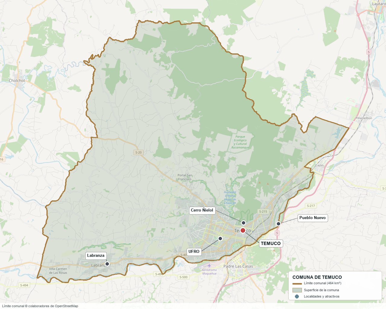
Commune boundary based on OpenStreetMap open data
§ 03 Location, Geography and Territory View
Where Temuco is, what it is built on and why water rules its land.
3.1 Location
Temuco lies about 675 km from Santiago via Route 5 South, in the central valley of La Araucanía, between the Coastal Range and the Andes. It borders, among others, Padre Las Casas (to the south, separated by the Cautín river), Vilcún and Freire. Freire is the commune that hosts the airport serving the city; to the west the commune boundary is with Nueva Imperial.
Plaza de Armas of Temuco · -38.7359, -72.5904
3.2 Terrain and setting
The city sits on the Cautín terraces, at an average elevation of about 120 meters, and rests on two low hills: the Ñielol (350 m), which reaches almost into the center, and the Conunhueno (360 m), on the eastern edge. The zoning plan designates as a restriction area every slope steeper than 15°, where a risk study is required before building.
3.3 Hydrography
Main bodies of water that shape the commune's land7 rows
| Watercourse | Role in the territory |
|---|---|
| Cautín river | Natural boundary with Padre Las Casas and axis of the wetlands; its banks Costanera del Cautín, Amanecer and Isla Cautín are flood-risk zones |
| Botrolhue system (Lircay, Coihueco and Botrolhue streams) | Drain the upper neighborhoods of El Carmen and Pedro de Valdivia; their limited capacity constrains development in that area |
| Aquelarre canal | Restriction strip where a linear park is planned |
| Río Cautín–Antumalén wetland | Urban wetland of about 194 ha, shared with Padre Las Casas (Law 21,202) |
| Laguna Temuco | Urban wetland of about 52 ha within the city |
| Lircay stream | Declared urban wetland of about 23 ha |
| Vegas de Chivilcán | Wetland of about 309 ha; the Tercer Tribunal Ambiental (Third Environmental Court) ordered 34 ha of private land to be excluded (2022) |
3.4 Soils and slopes
No commune-level soil survey was verified, so this document does not claim any agricultural suitability. What is documented is the contrast between two kinds of terrain: the flat river terraces, where water sets the limit, and the hillsides, where slope sets the limit.
- Advantage: the flat terrace allows urbanization with low earthmoving costs.
- Limitation: below 2° of slope erosion is nil to slight, but surface water drains poorly and the ground becomes waterlogged.
- Risk: above 15° of slope the zoning plan requires a risk study; the study underlying it describes colluvial movement on steep slopes and, above 45°, rockfalls and landslides.
- Real estate implication: the price per square meter rises with height above the river and with distance from the streams.
§ 04 Climate and Seasonality View
A short, dry summer and a long, rainy, frosty winter, in which firewood counts as much as the insulation of the house.
The monthly data come from the Dirección Meteorológica de Chile station at Maquehue (93 m), which is outside the built-up area; they are therefore a reference for the Temuco valley, not a measurement taken at the plaza. The Köppen classification is not consistent across the sources reviewed (both Cfb and Csb are cited), so no letter is fixed here: it is a temperate transitional climate with winter rains.
Reference climate parameters (Maquehue station, 1991–2020 normal)5 rows
| Parameter | Typical value | Comment |
|---|---|---|
| Mean annual temperature | 12.3 °C | January maximum 25 °C; July minimum 3.9 °C |
| Annual precipitation | 1,114.8 mm | June, with 209.6 mm, is the rainiest month |
| Rainy days per year | 114 | Concentrated between April and September |
| Frost | ~33 days a year | Between mid-April and mid-October (DMC) |
| Recorded extremes | 41.1 °C / −8.1 °C | Maximum recorded on 15 February 2019 |
June concentrates almost 210 mm, seven times January's: summer is dry and winter is mud. That explains the wetlands, the waterlogging risk that the zoning plan regulates neighborhood by neighborhood, and why a house without good stormwater drainage becomes costly in June.
No medium-term trend specific to the commune was verified. What is known is that winter firewood episodes shape the city's environmental agenda more than summer heat or drought.
§ 05 History: A Century and a Half on a Timeline View
A city that began as a military fort in 1881 and became a regional capital within a few decades thanks to the railway.
-
Before 1862
Mapuche country
The Cautín valley is Mapuche territory. The name Temuko is interpreted as "water of the temu", referring to the tree that grows in damp soils.
-
1862
The Malleco line
Cornelio Saavedra founds Angol and advances the Chilean military frontier southward, a step preceding the occupation of La Araucanía.
-
1881
Fuerte Recabarren
On 24 February the fort that gave rise to Temuco is founded. The sources consulted attribute the initiative to minister Manuel Recabarren Rencoret, not to Saavedra.
-
1883
End of the occupation
The military campaign in the area ends, with Saavedra and Gregorio Urrutia in command; Temuco consolidates its role as a garrison town and trading center.
-
1885–1913
Commercial elite and settlers
The city's merchant group takes shape and German, Swiss, French, English and Spanish settlers arrive. The urban layout is attributed to engineer Teodoro Schmidt.
-
1893
The railway arrives
The railway line connects Temuco with the rest of the country. The station and the railway workshop organize the city around the tracks, a legacy that the zoning plan still protects with a 10-meter non-building strip on each side.
-
1920
Gabriela Mistral at the Liceo de Niñas
The poet takes over as head of the girls' lyceum. Pablo Neruda studied at the Liceo de Hombres (sources differ on the year he enrolled, between 1910 and 1919).
-
1940
Museo Regional de La Araucanía
The regional museum opens its doors; today it operates in the Casa Thiers, a National Monument since 1996.
-
1987
Cerro Ñielol Natural Monument
Supreme Decree 617 of the Ministerio de Bienes Nacionales declares it a protected area, managed by CONAF; the zoning plan maintains it as a heritage protection area.
-
2004
Museo Ferroviario Pablo Neruda
Inaugurated on 24 February in the former EFE railway workshop, a site of about 153,000 m².
-
2010
Plan Regulador Temuco-Labranza
On 2 February the instrument that still governs comes into force, with later amendments (2012, text updated to November 2015).
-
2016
Closure of the Boyeco landfill
On 23 November the landfill is closed; since then waste has been taken to a sanitary landfill in Los Ángeles.
-
2025
New decontamination plan and zoning plan review
On 7 March the decree updating the Temuco–Padre Las Casas Decontamination Plan is published, and on 7 August the municipality orders the zoning plan to be modified, redefining the urban boundary.
§ 06 Cultural Identity and Indigenous Peoples View
One in four residents of Temuco identifies as Indigenous: the largest urban Mapuche presence in the area.
The 2024 Census records 71,483 people who identify as Indigenous in Temuco, 24.4 % of the commune's population. The Registro Social de Hogares (Social Household Registry) gives a similar figure (21.6 %, March 2025), although it is not a census measurement. Since 92 % of inhabitants live in an urban area, this population is above all urban, not rural: it is a feature of the city, not only of the countryside.
The cultural layers of Temuco5 rows
| Tier | Visible traces today |
|---|---|
| Mapuche | Place names (Temuko, Cautín, Botrolhue) and the communities recognized by CONADI within the urban boundary, protected by the zoning plan |
| Military-republican | The street grid and the plaza inherited from the 1881 fort |
| European settler | Surnames and trade of the first half of the 20th century; the zoning plan protects zones and buildings of historic conservation in the center |
| Railway | The station, the railway workshop (now a museum) and the 10 m protection strip on each side of the tracks |
| Literary | The Liceo de Hombres where Neruda studied and the Liceo de Niñas that Gabriela Mistral headed from 1920 |
In everyday life the mix is visible in the cultural offering and in local politics: the regional museum, fairs and calendar events such as We Tripantu (around the winter solstice, on 21 or 24 June depending on the source) are part of the city's calendar.
§ 07 Key Demographic Data View
7.1 Population and growth
Demographic indicators for Temuco and available benchmarks9 rows
| Indicator | Temuco | Distinction |
|---|---|---|
| Population, 2017 Census | 282,415 | Country: 17,574,003 |
| Population, 2024 Census | 292,518 | Country: 18,480,432 |
| Intercensal change | +3.6 % | Country: +5.2 % |
| Commune area | 464.0 km² | — |
| Population density (2024) | ~630 inhab/km² | — |
| Foreign-born population | 3.6 % (1.6 % in 2017) | Country: 8.7 % |
| Older Adults Index (IAM) | 76.4 (55.1 in 2017) | Country: 79.0 |
| Average schooling | 11.0 years | Region: 9.7 · Country: 10.4 |
| People with disabilities | 11.4 % | — |
7.2 Age structure (2024 Census)
Population distribution by age group5 rows
| Age group | Population 2024 (approx.) | % Commune |
|---|---|---|
| 0 – 14 years | 50,900 | 17.4 % |
| 15 – 29 years | 66,700 | 22.8 % |
| 30 – 44 years | 67,000 | 22.9 % |
| 45 – 64 years | 69,000 | 23.6 % |
| 65 years and over | 38,900 | 13.3 % |
The commune is growing well below the country (3.6 % versus 5.2 %) and aging quickly. How much of the conurbation's growth occurs in neighboring communes was not verified, but parcels there cost 3 to 6 times less (section 10).
Only 7.6 % of the population (22,197 people) lives in a rural area; the remaining 92.4 % (270,321) is urban. In terms of area the proportion is different: most of the 464 km² lies outside the urban area. The population figures by age group were calculated from the 2024 Census percentages applied to the commune total.
§ 08 Economic and Socioeconomic Data View
8.1 Poverty and social indicators (Casen 2024 and Registro Social de Hogares)
Social indicators for Temuco with their regional and national benchmarks4 rows
| Indicator | Temuco | Region | Country |
|---|---|---|---|
| Income poverty, Casen 2024 | 24.2 % | 28.6 % | 17.3 % |
| Multidimensional poverty, Casen 2024 | 13.0 % | — | — |
| People in households without basic services (RSH, Jun 2026) | 9.1 % | — | — |
| Overcrowded households (RSH, Jun 2026) | 7.6 % | — | — |
Casen 2024 uses a new methodology and is not comparable with 2022 (Temuco stood at 8.6 % under the previous one), so the jump does not mean that poverty has tripled. What it does show is a city below the regional average (28.6 %) and above the national one (17.3 %).
8.2 Economic activity (SII) and municipal finances (SINIM)
Business structure and municipal finances10 rows
| Economic indicator (SII / SINIM) | Value |
|---|---|
| Companies (SII, 2024) | 27,128 |
| Salaried workers (SII, 2024) | 147,509 |
| Construction workers (2024) | 33,515 |
| Retail and wholesale trade workers (2024) | 26,545 |
| Health workers (2024) | 21,714 |
| Total municipal revenue (SINIM, 2025) | $100,890 million |
| Permanent own revenue (SINIM, 2025) | $42,406 million |
| Transfers received (SINIM, 2025) | $12,387 million |
| Municipal spending on education (SINIM, 2025) | $68,219 million |
| Municipal spending on health (SINIM, 2025) | $54,912 million |
Education ($68,219 million) and health ($54,912 million) are the municipality's two largest expenditures, and permanent own revenue covers 42 % of total revenue: the rest depends on transfers.
§ 09 The Productive Engine: Services Capital of La Araucanía View
Temuco does not produce commodities: it sells services to south-central Chile, and that is where the value of its land comes from.
9.1 Retail and wholesale trade, construction and transport
In 2022 the SII recorded 25,906 companies in Temuco, of which 7,555 were in retail and wholesale trade, 2,822 in construction, 2,637 in transport and 2,564 in manufacturing. In 2024 the total rose to 27,128. The city is the commercial center of a region where the other communes are small.
Companies by sector in Temuco (SII, 2022)7 rows
| Sector | Companies | Interpretation |
|---|---|---|
| Retail and wholesale trade | 7,555 | 29 % of all companies; it is the sector with the most firms |
| Construction | 2,822 | 11 % of the total |
| Transport | 2,637 | 10 % of the total |
| Manufacturing | 2,564 | 10 % of the total |
| Health | 1,385 | 5 % of the total |
| Accommodation and food services | 1,363 | 5 % of the total |
| Agriculture and forestry | 951 | 4 % of the total |
9.2 Health and education as export industries
Temuco is the region's high-complexity health center (Hospital Hernán Henríquez Aravena) and the seat of UFRO and UC Temuco, which together received more than 22,000 applications in the 2025 PAES. Retail, rentals and construction depend on the students and patients who come from other communes.
9.3 Other economic pillars
- School education: 169 facilities and 64,615 enrolled students (2025).
- Public sector: public administration employed about 7,000 salaried workers in 2022.
- Agriculture and forestry: there are 951 companies in the sector, but they employ fewer people in the commune than retail and wholesale trade or construction.
§ 10 Real Estate Market View
10.1 Available properties and property types
Temuco's market has three layers. An urban market of apartments and houses in the center, Pueblo Nuevo, Av. Alemania and Labranza; a peri-urban fringe of 5,000 m² parcels toward the Lomas del Carmen areas and the roads leaving the city; and a rural market of farms in the north-west, such as the subdivided 93-hectare property that Produncan has listed in the commune. The portals (Yapo, Mitula, Portal Inmobiliario) show the listings, but they tag by city and not by commune boundary: it is advisable to check the commune of the property roll (rol) before comparing prices.
10.2 Reference price by property type (November 2026)
Indicative price ranges based on published listings8 rows
| Property type | Indicative price range | Notes |
|---|---|---|
| Parcel of about 5,000 m² on the fringe (Camino a Botrolhue and Lomas de Botrolhue, Yapo) | Median ≈ $24,900/m² (≈ $125 M for 5,000 m²); range $11,200 to $30,000/m² | Only 5 unique listings; these are asking prices, not closing prices |
| Parcel in Lomas del Carmen | UF 10,000 for 5,250 m² (≈ 1.9 UF/m²) | A second listing, $320 M for 5,812 m², was discarded as an outlier |
| Equivalent parcel in Vilcún, Cherquenco, Freire and Cholchol | $15 M to $45 M | 3 to 6 times less than near Temuco |
| Urban land, UFRO area | ≈ 10 UF/m² | Listing reference |
| Urban land, center | UF 11,780 for 620 m² (≈ 19 UF/m²) | The highest value in the sample |
| Lot in Labranza | $20 M to $23 M for 700 m² | Range of listings |
| Apartments | Median ≈ 48 UF/m² (range 33 to 60) | Yapo 2026, 6 listings; Mitula reported $2.02 M/m² in May 2026 (+0.4 % monthly) |
| Produncan subdivided farm (id 59) | $1,445 million for 93 ha (≈ $15.5 M/ha) | Produncan's own listing; the location is within the commune boundary |
The data are small samples, not a price index. Houses and the long-term trend were not verified.
10.3 What determines price in Temuco
Value drivers in this market, ranked by impact5 rows
| Factor | Price impact | How to check it here |
|---|---|---|
| Distance from urban Temuco | Very high: 3 to 6 times between the nearby parcel and one in Vilcún or Freire | Compare listings per m² within each commune, not across the whole region |
| Zoning plan zone | High: determines whether building is allowed and at what density | The municipality's interactive zoning map; certificado de informaciones previas (prior information certificate) from the Dirección de Obras |
| Flood risk (ARRI or ADUC) | High: can prevent building | PRC map and risk study approved by the Dirección de Obras Hidráulicas |
| Protected Indigenous territory (APTI) | High: restricts sale and purchase | CONADI records and title review by a lawyer |
| Water and sewerage | Medium: in Labranza the service is provided by a different water utility than in the rest of the commune | Ask the area's provider (see section 13) |
§ 11 Territorial Planning in Temuco View
What the Plan Regulador Temuco-Labranza allows and prohibits, and what changes with its modification.
Temuco is governed by the Plan Regulador Comunal de Temuco (the municipal zoning plan) (also called Temuco-Labranza), in force since 2 February 2010 with later amendments; the local ordinance is updated to November 2015. Its urban boundary includes Labranza. Outside that boundary the zoning plan does not apply but rural regulations do, and that is the case for much of the commune's area (only 7.6 % of the population lives in a rural area, but it occupies far more land). In 2025 the municipality ordered the instrument to be modified (Decreto 2,862, published on 7 August) to redefine the urban boundary and review the Indigenous lands included within it.
Lower-density residential zones and what they allow (local ordinance, 2015)5 rows
| Zone | Permitted use | Key restriction |
|---|---|---|
| ZHE3 (Medium-Density Residential) | Residential and community facilities; industry not allowed | Minimum lot 300 m²; 10.5 m height; maximum density 25 dwellings/ha |
| ZHE4 (Higher Low-Density) | Residential and community facilities; very limited commercial use | Minimum lot 1,000 m²; density 10 dwellings/ha; 50 m setback next to the Ñielol |
| ZHE5 (Lower Low-Density) | Residential and community facilities; very limited commercial use | Minimum lot 2,000 m²; density 5 dwellings/ha; 50 m setback next to the Ñielol |
| ZHE1 and ZHE2 | Residential | Minimum lot 200 m²; 14 m height; detached or semi-detached |
| ZM (Mixed 1 to 6) | Mixed use with community facilities | Specific rules per zone; the Labranza subdivisions fall in ZM2, ZM5 and ZHE2 (SEA resolution, 2022) |
The rule for low-density zones has a practical consequence: in ZHE5 (5 dwellings per hectare) a 5,000 m² parcel allows two dwellings, and it cannot be subdivided below 2,000 m². A subdivision buyer who counts on selling 500 m² lots within that zone has picked the wrong zone.
The plan defines risk and protection areas by name and location. Flood or waterlogging risk is declared in four conditioned areas: Costanera del Cautín, Isla Cautín, Costanera Amanecer and Labranza (between the Botrolhue stream and the Cautín river); in a fifth, El Carmen–Pedro de Valdivia, the condition concerns the capacity of the stream system, since all the parcels drain into the Botrolhue system. There are also restriction areas for slope (over 15°), for canals (5 m clear on each side), for infrastructure (cemetery, 25 m; high-voltage lines; the hospital helipad and the aeronautical restriction of the Maquehue aerodrome) and a railway strip of 10 m on each side of the tracks.
The protections that apply here and not just anywhere: the Cerro Ñielol Natural Monument (DS 617 of 1987), the historic conservation zones and buildings of the center, the APTI for Indigenous territories and, outside the plan but within the commune, the declared urban wetlands (Antumalén, Laguna Temuco, Estero Lircay, Vegas de Chivilcán). Ten communal parks have a declaration of public utility and therefore cannot be developed; among them those of Isla Cautín and the Costanera de Labranza.
§ 12 Neighbourhoods and Areas View
The city is organized around the Cautín river to the west and south, the Ñielol hill to the north and the historic center between the two. The zoning plan distinguishes consolidated residential zones, renewal zones in the center and along the riverbanks, low-density zones on the periphery and mixed zones.
City sectors and their profile8 rows
| Sector | Features | Market profile |
|---|---|---|
| Center | Renewal zone with arcades, hillside edge and historic conservation zones; concentrates museums, shops and the plaza | Land of up to about 19 UF/m²; apartments and offices |
| Pueblo Nuevo | Neighborhood of about 11.4 km² with 23,662 inhabitants (2010); renewal zone | Consolidated residential market |
| Av. Alemania / Pedro de Valdivia | Consolidated residential zones (ZH1 and ZH2); Pedro de Valdivia has areas with APTI and with a drainage-conditioned area | Apartment rentals of up to about $380,000 (Av. Alemania) |
| Amanecer and Costanera del Cautín | Riverside renewal zone with flood-conditioned areas (ADUC2 and ADUC5) | Revaluation potential subject to river defenses |
| El Carmen | Neighborhood with an area conditioned by drainage into the Botrolhue system | Conditioned residential expansion |
| Labranza | Peri-urban area about 14 km from the center, with its own water utility; mixed and low-density zones, with ADUC and APTI | Lots of $20 to $23 M; rentals from about $200,000 |
| Isla Cautín | Land between the riverbank defenses and the river, with a declared communal park and a flood restriction | Park use; not developable until the defenses are completed |
| Ñielol surroundings | Low-density zones with a mandatory 50 m setback from the natural monument | Urban country-living parcels of 1,000 to 2,000 m² |
§ 13 Basic Services, Utilities and Digital Connectivity View
In Temuco the question is not whether services exist but from which provider: Labranza is served by a different water utility.
Service providers and coverage7 rows
| Service | Provider / operator | Practical notes |
|---|---|---|
| Electricity | Grupo SAESA (according to a Produncan listing in the western rural area) | Confirm the connection point of each parcel with the distribution company |
| Urban drinking water | Aguas Araucanía (urban area) | Labranza has its own water concession: San Isidro S.A. |
| Rural drinking water | APR Committees and Cooperatives | Coverage and situation by area not verified |
| Sewerage | Aguas Araucanía; San Isidro in Labranza (activated sludge plant) | Conditioned zones require stormwater to be resolved |
| Heating | Firewood and other fuels | Decontamination plan: episode management season from 1 April to 15 September and a ban on wet firewood |
| Internet and phone | Entel fiber (2022) and Movistar, which connected Labranza in 2025 | Coverage percentage not verified |
| Waste collection | Municipal service | The Boyeco landfill closed in 2016; waste goes to a landfill in Los Ángeles (104,800 tonnes in 2023, more than $10,000 million a year) |
§ 14 Health View
Temuco is the high-complexity health center of La Araucanía: anyone who lives in the region is treated here sooner or later.
According to the July 2026 registry, the commune has 132 health facilities, and 258,357 people are enrolled in primary care (December 2025). The referral hospital is the Dr. Hernán Henríquez Aravena, which also treats patients from other communes.
Health network of the commune (July 2026)5 rows
| Facility | Type | Detail |
|---|---|---|
| Hospital Dr. Hernán Henríquez Aravena | High-complexity hospital | Self-managed; accredited in 2013 and re-accredited in 2017 by the Superintendencia de Salud. Address: Manuel Montt 115 |
| CESFAM | Primary care | 9 in the commune |
| CECOSF | Primary care | 5 in the commune |
| Rural health posts | Rural care | 3 |
| Hospitals | Total | 3 (includes the Hernán Henríquez Aravena) |
§ 15 Education View
15.1 School education
Temuco has 169 facilities and 64,615 students enrolled (2025). The 2025 SIMCE results, still preliminary, place the commune at around 280 points in Grade 4 reading.
2025 SIMCE results (preliminary, published 15 July 2026)7 rows
| SIMCE test | Temuco score |
|---|---|
| 4° básico (Grade 4), Reading | 281 |
| 4° básico (Grade 4), Mathematics | 268 |
| 8° básico (Grade 8), Reading | 242 |
| 8° básico (Grade 8), Mathematics | 263 |
| 8° básico (Grade 8), History | 254 |
| 2° medio (Grade 10), Reading | 253 |
| 2° medio (Grade 10), Mathematics | 265 |
15.2 Higher education
Temuco is home to the Universidad de La Frontera (main campus) and the Universidad Católica de Temuco (four campuses), as well as branches of other institutions. In the 2025 PAES, UC Temuco received 11,364 applications and UFRO 11,041. Enrollment by institution could not be verified.
Higher education institutions present in the commune4 rows
| Institution | Type | Remarks |
|---|---|---|
| Universidad de La Frontera (UFRO) | State university | Main campus; 11,041 PAES 2025 applications |
| Universidad Católica de Temuco | Private university | Four campuses; 11,364 PAES 2025 applications |
| Universidad Autónoma de Chile | Private university | Campus in Temuco |
| Universidad Mayor | Private university | Campus in Temuco |
§ 16 Wetlands, Hills and Natural Surroundings View
Temuco is a gateway to the lakes and volcanoes of the south, but those attractions lie outside the commune: Villarrica and Pucón are communes of Cautín Province 80 km or more away. What is distinctive about Temuco is something else: a hill and several wetlands inside the city.
Natural attractions in and around Temuco6 rows
| Attraction | Approx. distance | Activities |
|---|---|---|
| Cerro Ñielol Natural Monument | About 10 blocks from the plaza | Hiking and observation; 350 m high; CONAF |
| Río Cautín–Antumalén wetland | Inside the city | Urban wetland of about 194 ha, shared with Padre Las Casas |
| Laguna Temuco | Inside the city | Wetland of about 52 ha |
| Vegas de Chivilcán | Inside the commune | Wetland of about 309 ha, with 34 private ha excluded by the Tercer Tribunal Ambiental (2022) |
| Pucón | Between 80 and 110 km (depending on the source) | Lake, volcano, hot springs (outside the commune) |
| Conguillío National Park | About 80 km (one source) | Llaima volcano, araucaria forests (outside the commune) |
Temuco and the lake and volcanic landscape to the south
Within the commune the protected area is the Cerro Ñielol Natural Monument, which the zoning plan recognizes as a heritage protection area (APP 1). Urban wetlands are governed by Law 21,202.
§ 17 Connectivity and Transportation View
17.1 Road network
Temuco lies on the Route 5 South axis. The city is organized around a structuring road network of expressways, trunk roads and collector roads that the zoning plan declares to be of public utility.
Routes and distances4 rows
| Route / destination | Distance and details |
|---|---|
| Santiago | About 675 km via Route 5 South (other sources give up to 690) |
| Pucón | Between 77 and 112 km, depending on the source |
| Labranza | 14 km from the center, with buses about every 20 minutes |
| La Araucanía Airport (Freire) | About 24 km to the south, according to the MOP (September 2025) |
Temuco's position on the Route 5 South axis
17.2 Airport
The airport serving Temuco, La Araucanía, is in the commune of Freire, not in Temuco. The zoning plan maintains aeronautical restrictions for the Maquehue aerodrome and for the hospital helipad.
Airport profile3 rows
| Fact | Detail |
|---|---|
| Name | La Araucanía Airport |
| Commune | Freire |
| Distance to Temuco | About 24 km (MOP, 2025); other sources give between 20 and 25 |
17.3 Road and urban transportation
- Bus terminal: Rodoviario de La Araucanía, the city's main terminal.
- Urban transport: micro buses with fares of about $350 to $500 (2024 to 2026 estimates).
- Railway: EFE operates Victoria–Temuco (65 km) and Pitrufquén–Temuco services, with a new station at Cajón; the extension to Padre Las Casas was announced, but its status was not verified.
§ 18 Tourism: Development, Attractions and Things to Do View
18.1 Tourism development
Temuco is more a city of passage and business than a tourist destination. Sernatur records 1,811,467 domestic trips associated with Temuco in 2024, although the indicator is unclear; foreign arrivals in La Araucanía would be 166 thousand in 2023 and 328 thousand in 2024, according to a statement by the regional governor that was not verified.
18.2 Tourist attractions in the commune
- Cerro Ñielol: natural monument about 10 blocks from the plaza.
- Urban wetlands: Antumalén, Laguna Temuco and Vegas de Chivilcán, now protected by Law 21,202.
18.3 Museums and culture
- Museo Nacional Ferroviario Pablo Neruda: Barros Arana 565, inaugurated on 24 February 2004 in the former EFE railway workshop (about 153,000 m²).
- Museo Regional de La Araucanía: in the Casa Thiers, a National Monument since 1996; the museum has operated since 1940.
- The lyceums of Neruda and Mistral: the Liceo de Hombres, where Neruda studied, and the Liceo de Niñas, which Gabriela Mistral headed from 1920.
18.4 Calendar of events and traditions
Main events of the year3 rows
| Period | Event | Character |
|---|---|---|
| 24 February | City anniversary | Founding date (1881) and also the date of the Railway Museum's inauguration (2004) |
| June | We Tripantu | Mapuche new year around the winter solstice (sources give 21 or 24) |
| 1 April to 15 September | Decontamination plan season | Restriction on the use of wet firewood and management of critical episodes |
§ 19 Everyday Life, Sport and Practical Information View
What anyone who is going to live in Temuco, not just visit it, needs to know.
19.1 Air and firewood
Temuco and Padre Las Casas share an atmospheric decontamination plan for particulate matter. The updated version (DS 08/2023 of the Ministerio del Medio Ambiente, published on 7 March 2025) bans wet firewood and sets an episode management season from 1 April to 15 September. The number of critical episodes in 2025 could not be verified.
19.2 Safety
According to the CEAD (2024), Temuco records 1,918.3 violent crimes per 100 thousand inhabitants, below the national average (2,222.7) and above the regional one (1,880.2). Domestic violence, at 668.4 per 100 thousand, is above the country's rate (601.0).
19.3 Cost of living and practical considerations
- Rent for a 1- to 2-bedroom apartment: between about $200,000 (Labranza) and $380,000 (Av. Alemania) in 2026, according to portal estimates; they are not an official statistic.
- Heating: in winter you need to budget for dry firewood or an alternative system, because of the restriction on wet firewood.
- Transport: the micro bus costs between $350 and $500 depending on the source.
§ 20 Territorial Analysis: Strengths, Challenges and Opportunities View
An honest reading of the territory. A sound investment decision also requires knowing what doesn't work.
- Regional capital with a high-complexity hospital, two large universities and 27,128 companies.
- Educated population: 11.0 years of schooling versus 9.7 for the region.
- Cerro Ñielol and urban wetlands inside the city.
- The 24.2 % income poverty rate (Casen 2024) is noticeably higher than the national average (17.3 %).
- Rapidly aging population: the older adults index rose from 55.1 to 76.4 in seven years.
- Green space deficit: 6.03 m² per inhabitant, compared with the WHO reference of 9 m² (2010 study).
- Pollution from firewood, with a decontamination plan in force.
- The zoning plan modification (2025) may order the urban edge and Indigenous lands.
- Land in conditioned zones that is unlocked when the Cautín defenses are completed.
- Stable student and health-related demand for small-apartment rentals.
- Land sales involving APTI or flood areas not disclosed in the listing.
- Slow growth (+3.6 % in seven years) that may cool demand for new subdivisions.
- Dependence on construction employment (33,515 workers) in the face of changes to the zoning plan.
Temuco: Territory, Connectivity and Opportunities
Temuco offers what few communes in the south do: a complete city, with services, universities and a hospital, at a reasonable distance from the lakes and volcanoes. For the investor, the opportunity lies in understanding the zoning plan before buying, because that is where it is decided which land is worth what it costs and which is not.
At Produncan Lands we know this territory and its opportunities. Our work is to connect properties with people looking to invest, live and develop new projects in southern Chile, offering our experience, local knowledge and commercial reach.
We invite you to get to know our properties in Temuco and throughout southern Chile, and to entrust Produncan Lands with the marketing of your property.
View properties at Produncan Lands§ 22 Sources and Methodology Note View
22.1 Sources consulted
Documents and sources used7 rows
| Scope | Document and year |
|---|---|
| Demographics, Casen, SII, SINIM, SIMCE, health, education | Reporte Comunal Temuco, BCN, 2026 edition: 2017 and 2024 Census, Casen 2024, SII 2024, SINIM 2025, SIMCE 2025 |
| Companies by sector 2022 | Reporte Comunal Temuco, BCN, 2024 edition |
| Zoning plan | Plan Regulador Comunal de Temuco: Ordenanza Local updated to November 2015, Municipalidad de Temuco |
| Zoning plan modification | Diario Oficial, 7 August 2025, Decreto 2,862 of the municipality |
| Climate | Heladas en Temuco, Dirección Meteorológica de Chile; monthly table for the Maquehue station, 1991–2020 normal |
| Real estate market | Yapo and Mitula listings, 2026; Produncan property id 59 |
| History and culture | Memoria Chilena and secondary sources; founding date of 24 February 1881 |
22.2 Methodology note and data currency
- The 2025 SIMCE results are preliminary and may be adjusted.
- The Köppen climate classification, the hospital's current number of beds, university enrollment, sanitation coverage and the soil survey could not be verified and were therefore left out.
- The Maquehue weather station is outside the built-up area; its data are a reference for the valley.
- The zones in section 11 were read from the local ordinance updated to November 2015; the zoning plan has been under modification since 2025 and its zoning may change.
- Real estate price ranges are indicative only and do not constitute an appraisal. Each property must be assessed individually.
- This document does not constitute legal or tax advice.
- Closing date of this edition: November 2026. It is recommended to review the indicators in sections 7, 8 and 10 annually.
Territorial reference document prepared by Produncan Lands. It brings together official information (INE, BCN, SII, SINIM, MINEDUC, MINSAL, MMA) with local market knowledge, so that anyone —resident, visitor, investor or buyer— can understand Temuco in depth before making a decision.