
TimaukelThe commune without towns, between the Bahía Inútil steppe and the Cordillera Darwin
History, Nature and Opportunities in the Southernmost Commune of Isla Grande de Tierra del Fuego
TEMÁUKEL
Temáukel, the Supreme Being of the Selk'nam, lends his name to a commune that has no towns. Before 1880 the Selk'nam, in their two groups, the Kauxsel and the Kauwes, roamed these lands, and the Kawésqar sailed the Seno Almirantazgo; at Puerto Arturo, now inside Karukinka Park, 42 archaeological sites remain as a record of them.
Then came the sheep brought from the Falkland Islands (Malvinas) and the Scottish managers. In 1904 the Sociedad Explotadora founded the Cameron estancia (sheep ranch) on the McClelland River, and ever since, the unit of settlement has been not the town but the estancia headquarters, with its wooden shearing shed. Russfin was left with a rusting gold dredge and, for 34 years, a lenga sawmill that closed in October 2025.
Today the west wind, which some days exceeds 100 km per hour, sweeps the Bahía Inútil steppe, and further south the lenga forest and peat bogs climb to the ice of the Cordillera Darwin. The beavers introduced in 1946 have made ponds in every valley; guanacos graze on the Karukinka pampa; at Pampa Guanaco a school, a police outpost and an 800-meter asphalt airstrip are all there is of a town, and it is there that the municipality wants to build the new capital.
Version 1.0 · Expanded edition · October 2026
The Commune at a Glance
The essential data on Timaukel at a glance. Each figure is developed in the corresponding section.
Administrative identification and reference data12 rows
| Fact | Detail |
|---|---|
| Official name | Commune of Timaukel (CUT code 12303) |
| Region / Province | Magallanes and Chilean Antarctica / Tierra del Fuego (Porvenir, Primavera and Timaukel); the provincial capital is Porvenir |
| Demonym | Timaukelino/a (BCN) |
| Capital | Villa Cameron, 53°38′ S, 69°38′ W, on the south coast of Bahía Inútil; the municipality plans to move it to Pampa Guanaco |
| Area | 10,758.9 km² (BCN). The zoning plan and the municipality cite 12,850 km²: these are two different official figures, and it is not known which corresponds to the boundary decree |
| Boundaries | Porvenir to the north, Argentina (Tierra del Fuego province) to the east, the Whiteside Channel to the west, and the Seno Almirantazgo and Cordillera Darwin to the south; about 100 km of border |
| Urban areas | None: the commune is 100 % rural (2024 Census) |
| Dialing code | +56 61 |
| Time zone | UTC−3 all year (Magallanes Region) |
| Climate classification | Tundra (ET) and cold Mediterranean (Csc) according to the zoning plan; no weather station of its own |
| Creation of the commune | DL 2,868, enacted on 21 September and published on 26 October 1979 |
| Municipality | Municipality of Timaukel, Villa Cameron s/n; mayor Luis Barría Andrade and six councillors (BCN, 2026). District 28, senatorial constituency 15 |
Overview
Timaukel is a commune of 10,759 km² where the 2024 Census counted 157 people: one for every 69 km², the least populated in the province of Tierra del Fuego. It occupies the south of Isla Grande, from the coast of Bahía Inútil, where its capital, Villa Cameron, is located, to the ice of the Cordillera Darwin and the border with Argentina. It is 100 % rural: it has not a single urban area. People live at estancia headquarters, in two hamlets (Cameron and Pampa Guanaco) and in fishing cabins, and of the 117 employed residents the Census counts 32 in livestock and forestry and 30 in public administration.
Its role is that of a territory of passage and conservation. 57 % of the commune is protected area, according to the zoning plan: Karukinka Park (almost 300,000 ha, privately owned by the Wildlife Conservation Society), Alberto de Agostini National Park, part of Yendegaia National Park and the Seno Almirantazgo marine protected area. The rest is steppe, lenga forest and peat bog, shared among a few estancia owners and some second-home subdivisions around Lago Blanco and Lago Fagnano. Timaukel is reached by gravel road and almost no one lives here year-round: it depends on Porvenir and Punta Arenas for the hospital, high school, notary and bank.
The contrast with its neighbors defines its character. Porvenir, the provincial capital, has a hospital, a notary, a Real Estate Registrar (Conservador de Bienes Raíces) and 78 tourism providers; Timaukel had nine in 2019 (PLADETUR). Primavera, the other commune in the province, is the ENAP town of Cerro Sombrero, with its heritage zone and its gas wells: it is not Timaukel, although many listings and guides mix it up with it. Timaukel has no recorded oil, no modernist town, no waterfront promenade: it has land, and the most extensive and least altered land on the island.
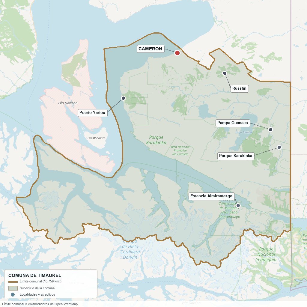
Commune boundary based on OpenStreetMap open data
§ 03 Location, Geography and Territory View
Where Timaukel is, what it is built on, and why the shape of the ground decides what can be done on it.
3.1 Location
Timaukel is the southernmost commune of the province of Tierra del Fuego and of Isla Grande. It occupies the south coast of Bahía Inútil, the Whiteside Channel to the west and the Seno Almirantazgo in the southernmost sector, and shares about 100 km of international border with Argentina. Its outline comes from DL 2,868 of 1979: it was formed from the former commune of Bahía Inútil, without the districts of Caleta Josefina and San Sebastián or the northwestern part of the Cameron district (which went to Porvenir), and with the Darwin district of the former commune of Navarino. That is why Villa Cameron sits right on the boundary with Porvenir. The capital is 336 km from Punta Arenas via the Primera Angostura route and about 150 km from Porvenir; the zoning plan places it "in the geometric center of the island" and describes it as the second most isolated commune in the region, surpassed only by Cabo de Hornos.
Villa Cameron · 53°38′ S, 69°38′ W
3.2 Terrain and setting
The territory has three bands running north to south. In the north, the Magellanic pampa: steppe of grasses and shrubs on marine and glacial sediments, where the estancias are concentrated. In the center, a transition band of lenga forest, peat bogs and second-growth stands, with lakes Lynch, Chico and Blanco. In the south, the Cordillera Darwin, of intrusive, metamorphic and volcanic rock, whose peaks reach 2,438–2,469 m and which the fjords of the Seno Almirantazgo cut into channels. Beneath Lago Fagnano runs the Magallanes–Fagnano fault, which produced the December 1949 earthquake (two magnitude 7.8 quakes within nine hours).
Near the coast of Bahía Inútil, at "Loma Zorro," there are erratic boulders that the ice carried down from the Cordillera Darwin during the last glaciation. The Marinelli and Brookes glaciers are in the southern sector; snow and glaciers cover 11.3 % of the commune's surface (CONAF, 2019).
3.3 Hydrography
Main bodies of water in the commune7 rows
| Body of water | Role in the territory |
|---|---|
| Bahía Inútil | A bay of flat shores and shallow bottoms that connects the Strait of Magellan with the Whiteside Channel; Cameron lies on its south shore. It owes its name to the fact that in 1827 it was found unfit for navigation |
| Río Grande | Rises in Karukinka; about 140 of its 240 km run in Chile, without dams or power plants, and it empties beside the Argentine city of the same name. It is the island's fly-fishing river |
| Lago Blanco | 148 km² at 120 m a.s.l., with a major axis of 25 km; it receives five tributaries from the south. It lies about 11 km from Pampa Guanaco and is the commune's attraction of international standing |
| Lagos Chico, Lynch and Deseado | Central lake system (Lynch, Chico, Blanco) and a fishing lake further south, with lodges |
| Lago Fagnano (Kami) | 590 km² in total, of which only 43 km² (7 %) lie in Chile; its western end, Caleta María, is within the commune. Sacred to the Selk'nam |
| Seno Almirantazgo | A fjord 80 km long and 1,160 km²; Karukinka has 50 km of coastline on it. It is the only elephant seal breeding site in southern Chile (WCS, 2014) |
| McClelland and Catalina rivers | They pass through Cameron and Pampa Guanaco; they supply both settlements and flood them during high water |
3.4 Soils and vegetation
The soils are clayey, from moraine deposits, with high water retention and very low infiltration, which explains the peat bogs and the poor seismic behavior of the ground (PRC, 2023). According to the 2019 CONAF land-cover survey, grassland and scrub cover 34.9 % of the commune, forest 34.8 % (lenga 314,507 ha and Magellanic coigüe 65,630 ha), wetlands, almost all peat bogs, 9.5 %, and farmland barely 0.7 % (8,110 ha).
- Advantage: extent, abundant water in the center and south, and standing native lenga forest.
- Limitation: barely 8,000 ha is farmland; most of the soil is low-carrying-capacity grassland, peat bog or rock.
- Risk: peat beneath the lot (ground that sinks and cannot bear foundations), waterlogging caused by beavers, and frosts on 127 days a year on the steppe.
- Real estate implication: the cost of building in Timaukel is around $1,000,000 per m² (PRC, 2023), and "firm ground, not peat" is today a selling point.
§ 04 Climate and Seasonality View
A cold, windy steppe climate, where winter sets the calendar for the whole commune.
Within Timaukel there is no weather station with published normals; the nearest are in Porvenir (strait coast), Río Grande (Argentina, eastern steppe), Ushuaia (mountains and the Beagle Channel) and Punta Arenas. The zoning plan describes tundra (ET) and cold Mediterranean with winter rainfall (Csc) and cites a mean annual temperature of 6.4 °C with no primary source; a climate grid for the Lago Blanco area gives 4.2 °C and 440 mm. The chart uses Río Grande as a reference for the steppe of the Río Grande valley and Pampa Guanaco.
Reference climate parameters (1991-2020 normals from nearby stations; none within the commune)9 rows
| Parameter | Typical value | Comment |
|---|---|---|
| Annual precipitation, Río Grande (Arg.) | 326 mm | Eastern steppe; 69 days with 1 mm or more of rain |
| Annual precipitation, Ushuaia | 458 mm | It rises toward the mountains; the Lago Blanco grid gives 440 mm |
| Mean annual temperature, Porvenir | 6.5 °C | Simple calculation from the 12 monthly means; July 1.7 °C, January 10.8 °C |
| Mean January maximum | 13.6–16.5 °C | Ushuaia 13.6 °C, Río Grande 16.0 °C and Porvenir 16.5 °C: summer is cool |
| Mean July minimum | −3.0 °C | Río Grande: 127 days a year with a minimum below 0 °C |
| Days with snow | 16 to 60 a year | Río Grande 16.5 and Ushuaia 59.5; in Cameron: no verified data |
| Wind | West and southwest | Gusts that sometimes exceed 100 km/h (PRC, 2023); no published measurements exist for Cameron or Pampa Guanaco |
| Daylight at the December solstice | 17 h 4 min | Astronomical calculation for Cameron; in June, about 7 h 26 min |
| Frosts and winds of more than 100 km/h | Regular events | These are the two phenomena the municipality declares to be habitual (PRC, 2023) |
Reference station: Río Grande B.A. (Argentina), about 100 km east of Pampa Guanaco; Timaukel has no station with published normals. Rainfall is scarce and almost even throughout the year (326 mm), with peaks in December and January; what changes is the temperature: from June to August the average is around 0 °C and there is frost 127 days a year. Toward the mountains precipitation rises (458 mm in Ushuaia) and the landscape changes, from steppe to forest.
The trend that matters most is not rainfall but energy: in 2018 the Ministry of Energy assessed Cameron's wind resource for a 24-hour hybrid wind-diesel system, and the PRC states that the island holds 41 % of the region's wind capacity. No wind project built in the commune was found.
§ 05 History: From Temáukel to the Capital on the Move View
A land that passed from the Selk'nam to a sheep-farming society, to a wood-chip project, to a private park given away by a bank; and a commune whose capital has already moved once and wants to move again.
-
Before 1880
Selk'nam and Kawésqar
The Selk'nam, in their Kauxsel and Kauwes groups, roam the territory and the Kawésqar use the Seno Almirantazgo. Karukinka holds 80 archaeological finds, 42 of them at Puerto Arturo, and WCS speaks of more than 10,000 years of occupation. The commune's name comes from the Selk'nam Temáukel, the "Supreme Being."
-
1827
Bahía Inútil
The bay is named for the fact that its shallow bottoms were of no use for navigation. Today it is the northern edge of the commune and the axis of the coastal road leading to Cameron.
-
1890–1894
Concession and the Sociedad Explotadora
One million hectares of Isla Grande are granted to the Portuguese José Nogueira. After his death, his widow Sara Braun and his brother-in-law Mauricio Braun found the Sociedad Explotadora de Tierra del Fuego in 1893, and in 1894 Alexander Cameron takes over management of the Caleta Josefina estancia, the first one. The Salesian mission on Isla Dawson, across from the commune, operates between 1890 and 1912 and receives deported Selk'nam, with high mortality.
-
1904
The Cameron estancia
It begins as the McClelland River sub-section of Caleta Josefina and becomes the Sociedad Explotadora's third establishment, with sheep, Hereford cattle and sawmills. In 1918 it was managed by the Scotsman W. Greer. Villa Cameron now stands on its headquarters.
-
1904–1910
The Russfin dredge
Tourism guides place in those years the gold dredge that was brought from England to the Russfin River; in 1907-1908 there were twelve dredges on Isla Grande. The abandoned dredge is still on the site. Its status as a national monument, which some guides attribute to a 1976 decree, could not be confirmed.
-
1908–1920
Yartou, Vicuña and Russfin
In 1908 the Puerto Yartou sawmills are founded. In 1915 the Vicuña estancia is born, the last of the great first-generation estancias, on the state lands between Lago Blanco and the border; in 1920, Russfin as a section of Cameron.
-
1927
The commune of Bahía Inútil
On 30 December the department of Tierra del Fuego is created with the communes of Primavera, Porvenir, Bahía Inútil and Navarino. Bahía Inútil is the direct predecessor of Timaukel.
-
1946
The beavers
North American beavers are introduced on the Argentine side of the island for a fur industry. Ten years later the first reports arrive from the Chilean side of Fagnano. Today there are more than 100,000 on the island and they alter the forests and peat bogs of Karukinka and Pampa Guanaco.
-
1949
The Tierra del Fuego earthquake
On 17 December, two magnitude 7.8 quakes within nine hours rupture the Magallanes–Fagnano fault; the damage was slight because of the sparse population. The zoning plan, curiously, states that there is no historical record of earthquakes in the commune.
-
1957–1973
The end of the latifundio
In 1957 the State stops renewing public-land leases; in 1958 it recovers the Vicuña lands. In 1971 Agrarian Reform expropriates the Cameron estancia, which passes to a cooperative until 2008, and in 1973 the Sociedad Explotadora is dissolved.
-
1965
The ENAP fishing club
ENAP workers from Cerro Sombrero (commune of Primavera) establish the Fishing and Hunting Club based at Lago Blanco. It is the clearest human link between the oil town and Timaukel, and to this day the club offers cabins and boats.
-
1979–1988
Timaukel is born
DL 2,868 (enacted on 21 September and published on 26 October 1979) forms it from Bahía Inútil minus its northern sector, which goes to Porvenir, plus the Darwin district of Navarino: it is not a split from Porvenir but the trimmed heir of Bahía Inútil. The initial capital is the locality of Timaukel; in 1988 it moves to Cameron, where the estancia donated 2 ha for the municipality.
-
1991–1992
Forestal Russfin
With the backing of Fundación Chile and under the Navarino Law, the Russfin sawmill and lenga drying plant is born. It came to be the only industry in the commune.
-
1990s–2004
Trillium, Goldman Sachs and Karukinka
A U.S. forestry company buys state land in the 1990s and plans to harvest 272,000 ha of forest for wood chips; in 1998 CONAMA approves the environmental study, there are legal protection appeals and social opposition, and the company goes bankrupt around 2002. Goldman Sachs acquires the debt and the land and in 2004 donates them to the Wildlife Conservation Society: Karukinka Park is born.
-
2013–2015
Yendegaia and Karukinka protected
In December 2013 Bienes Nacionales decree 118 is enacted, creating Yendegaia National Park, shared with Cabo de Hornos, and in 2015 Karukinka is declared an Area of Scientific Interest for Mining Purposes: research is prioritized over mining exploitation.
-
2023
Recognition of the Selk'nam people
Law 21,606 incorporates the Selk'nam as the eleventh indigenous people under Law 19,253, after decades in which they were considered extinct.
-
2025–2026
Russfin closes and the capital looks to Pampa Guanaco
In August 2025 Forestal Russfin announces its closure, phased through October. In April 2025 Bienes Nacionales hands 53 ha at Pampa Guanaco over to the municipality, and in June 2026 the subsidies for the first 30 rural homes are awarded; the actual move of the capital has still not materialized.
§ 06 Cultural Identity and Indigenous Peoples View
A commune of 157 people where 21 % declare themselves part of an indigenous people, but almost all are Mapuche: the people for whom it is named were reduced to a single person in the Census.
In the 2024 Census, 33 of the 157 people (21.0 %) belong to or consider themselves part of an indigenous people, compared with 23.2 % in the region and 11.4 % nationally. Of these, 32 are Mapuche and 1 is Selk'nam; there is no other people. With so few people and an acknowledged low census coverage, the figure does not allow trends to be drawn: the 2017 Census had counted 77 people (19 %), also predominantly Mapuche.
The cultural layers of Timaukel4 rows
| Tier | Visible traces today |
|---|---|
| Selk'nam and Kawésqar | Name of the commune (Temáukel), of Karukinka ("our land") and of Lago Fagnano (Kami); archaeological sites at Puerto Arturo; the Fire Festival of 21 June; Selk'nam communities from Porvenir who collaborate with WCS and with the municipality |
| British estancias | Headquarters of the Cameron estancia, with its wooden shearing shed and managers' houses, and the Cameron church; Scottish and New Zealand managers (Cameron, Greer); sheep brought from the Falkland Islands (Malvinas) |
| Fieldwork and estancia | Workers on rotation: only 2 % were born in the commune and 34 % reported in 2017 a usual residence in another commune, mostly Punta Arenas; 84.7 % were men. Housing provided by the employer, summer-pasture posts and work camps |
| Recent pioneers | Those who came for the municipality, the sawmill or the school: civil servants, teachers and paramedics in Cameron and Pampa Guanaco, a settlement born as a functional site, with a police outpost, a school and an airfield |
The legal recognition of the Selk'nam people (Law 21,606, October 2023) changes the framework of the commune that bears their name: for anyone buying land, it is advisable to consult CONADI's register of indigenous communities and lands before a transaction on properties near archaeological sites, something that this research was unable to verify (no list of Indigenous Development Areas for Magallanes turned up).
In daily life the mix is barely noticeable, because there is almost no community life: there is a guanaco festival in Pampa Guanaco (the third edition was announced for November 2025), the fishing championship on lakes Lynch and Blanco, and the Timaukel Day that the municipality organized in Santiago in 2026 to publicize the commune.
§ 07 Key Demographic Data View
7.1 Population and growth
Comparative demographic indicators12 rows
| Indicator | Commune | Region | Country |
|---|---|---|---|
| Population, 2017 Census | 405 | 166,533 | 17,574,003 |
| Population, 2024 Census | 157 | 166,537 | 18,480,432 |
| Intercensal change | −61.2 % | 0.0 % | 5.2 % |
| Commune area | 10,758.9 km² | — | — |
| Population density (2024) | 0.015 inhab./km² | — | — |
| Rural population (2024) | 100 % | 7.1 % | 13.3 % |
| Foreign-born population (2017) | 1.5 % | 2.8 % | 4.2 % |
| Foreign-born population (2024) | no data | 6.6 % | 8.7 % |
| Sex ratio 2017 / 2024 | 553.2 / 153.2 | 104.9 / 98.1 | 95.9 / 94.3 |
| Demographic Dependency Ratio (IDD) 2024 | 31.9 | 45.4 | 46.5 |
| Elderly Index (IAM) 2024 | 40.7 | 87.1 | 79.0 |
| Indigenous peoples (2024) | 21.0 % | 23.2 % | 11.4 % |
7.2 Age structure (2024 Census)
Population distribution by age group6 rows
| Age group | 2017 Census | 2024 Census | % Commune 2024 |
|---|---|---|---|
| 0 – 14 years | 28 | 27 | 17.2 % |
| 15 – 29 years | 90 | 26 | 16.6 % |
| 30 – 44 years | 117 | 45 | 28.7 % |
| 45 – 64 years | 145 | 48 | 30.6 % |
| 65 years and over | 25 | 11 | 7.0 % |
| Total | 405 | 157 | 100 % |
The drop from 405 to 157 people (−61.2 %) is not explained by a mass emigration of residents: it is explained by who gets counted. In 2017 the Census recorded 343 men and 62 women (84.7 % men), only 58 % with usual residence in the commune and 34 % with usual residence in another commune, mostly Punta Arenas: they were fieldwork and seasonal workers. In 2024 there are 95 men and 62 women, that is, the number of women did not change and what disappeared was the floating population. This is our own reading, not a published figure; the authorities continue to cite 423 inhabitants (the 2002 Census figure) and the 2024 Census counted 157.
100 % of the population is rural. By locality, the 2024 Census counts 61 people and 28 dwellings in Cameron and 15 people and 8 dwellings in Pampa Guanaco; in 2017 there were 96 and 16. The 2025 electoral roll has 732 registered voters, more than four times the census-counted residents, and turnout was 33.2 % versus 76.5 % in the region: many registered voters do not live in the commune.
§ 08 Economic and Socioeconomic Data View
8.1 Poverty and social indicators (CASEN 2024 and Social Household Registry)
Social indicators compared6 rows
| Indicator | Commune | Region | Country |
|---|---|---|---|
| Income poverty, Casen 2024 | 4.8 % | 9.9 % | 17.3 % |
| Multidimensional poverty, Casen 2024 | 3.6 % | 6.1 % | 17.7 % |
| People in households lacking basic services (RSH, June 2026) | 45.1 % | 6.8 % | 12.9 % |
| Overcrowded households (RSH, June 2026) | 7.4 % | 5.0 % | 7.8 % |
| Indigenous population (2024 Census) | 21.0 % | 23.2 % | 11.4 % |
| Average years of schooling (2024 Census) | 10.7 | 10.7 | 10.4 |
Poverty rates are low, but they should not be read as well-being: with 157 people, the survey sample is minimal and almost all households have housing provided by the employer, so income is mixed with free housing. The indicator that does describe the commune is a different one: 45.1 % of people live in households lacking basic services, seven times the regional figure. It is the measure of what it means to live without a water network, sewerage or continuous electricity.
8.2 Economic activity (SII) and municipal finances (SINIM)
Business structure and municipal finances12 rows
| Economic indicator (SII / SINIM) | Value |
|---|---|
| Businesses with registered sales or activity (SII 2022 / 2023 / 2024) | 30 / 27 / 25 |
| Businesses in 2024 by size | 14 micro, 3 small, 1 medium, 1 large, 6 without sales |
| Reported salaried employees (SII 2024) | 263 (255 in 2022) |
| Manufacturing (SII 2024) | 157 workers, 59.7 % of the commune total |
| Public administration (SII) | 48 workers in 2024; there were 73 in 2022 |
| Agriculture, livestock, forestry and fishing (SII 2024) | 8 businesses and 37 workers |
| Accommodation and food services (SII 2024) | 6 businesses and 19 workers (8 and 26 in 2022) |
| Total municipal revenue received (SINIM 2025) | M$ 2,980,760 |
| Contribution from the Municipal Common Fund (2025) | M$ 2,251,362 (75.5 % of revenue; 60.2 % in 2023) |
| Permanent own-source revenue (2025) | M$ 130,240 (4.4 %): business licenses M$ 46,938 and vehicle permits M$ 43,970 |
| Territorial Equity Fund from the mining royalty | M$ 279,927 in 2025 (M$ 119,636 in 2024) |
| Municipal expenditure incurred (2025) | M$ 3,252,602: exceeds revenue by M$ 271,842 |
The structure is that of a commune without its own tax base: 75.5 % of municipal revenue comes from the Municipal Common Fund, permanent own-source revenue is 4.4 % and the municipal share of property tax is zero, because there are almost no taxable properties. The coincidence between the single "large" business and the 157 manufacturing workers points to a single firm, Forestal Russfin (inference: the SII does not publish names), which closed in October 2025: the 2024 figures in any commune profile predate the closure and overstate the current economic base.
§ 09 The Productive Engine: Sheep Estancias, Lenga and Conservation View
Timaukel is not an oil commune, like neighboring Primavera: it lives off sheep, the municipality and, until 2025, a sawmill. Understanding that explains why the land is worth what it is worth.
9.1 Sheep farming: the territorial base
The unit of settlement is the estancia. The INE recognizes eight estancia hamlets plus Pampa Guanaco, and the largest landowner is Sociedad Agrícola Ganadera Cameron Ltda., with about 100,000 ha around Villa Cameron (close to 9 % of the commune; the estancia was founded in 1904). In the 2024 Census, 32 of the 117 employed residents (27.4 %) work in livestock and forestry. The sector is going through its worst crisis in decades across the region: the Asociación de Ganaderos counts about 700 thousand head lost in a decade, with prices of about $33,000 per lamb (February 2024), because of the guanaco (from 28,000 in 1978 to more than 500,000 according to the trade association), feral dogs and predation.
The pillars of Timaukel's economy and their situation5 rows
| Pillar | Key figure | Situation in 2026 |
|---|---|---|
| Sheep estancia | 27.4 % of employed residents (32 of 117); Cameron, about 100,000 ha | Sector in regional crisis; the 2021 Agricultural Census by commune could not be obtained |
| Public spending | 36.8 % of employed residents (30 in public administration and 13 in education) | Depends on the Municipal Common Fund (75.5 %) and on transfers |
| Forestal Russfin | 157 of 263 salaried workers (SII 2024); lenga 314,507 ha in the commune | Closed in October 2025; the fate of its properties and its fuel pump is not verified |
| Conservation | Karukinka 298,826 ha; 57 % of the territory protected | Growing appeal for nature tourism, with no infrastructure or visitor figures |
| Tourism and fishing | 6 accommodation and food businesses with 19 workers (SII 2024) | Incipient: the commune has an attraction of international standing (Lago Blanco) but only 9 providers (PLADETUR, 2019) |
9.2 Forestal Russfin: the only industry and its closure
Russfin was a lenga sawmill and drying plant, started in 1991-1992 with the backing of Fundación Chile under the Navarino Law. In 2019 the SII counted about 240 workers in "sawing and planing," 56 % of the entire registered workforce. In August 2025 it announced its definitive closure, phased through the end of October, after four years of losses, weak demand and logistics costs due to remoteness; a pellet plant did not reverse the situation. Direct workers numbered 73 according to the regional press and "more than a hundred" according to the authority, and almost all lived in Porvenir and Punta Arenas.
The effect on the commune was not on resident employment, which was zero (the 2024 Census counts no employed person in manufacturing), but on logistics: Russfin was the municipality's only fuel supplier and the only fuel pump in the south of the island, and its services —lodging, food and tire repair— do not exist within a radius of at least 180 km, according to a local leader. What will happen to its forested properties, its headquarters and its fuel pump does not appear in any public source as of this edition.
9.3 Hydrocarbons: what falls inside and what does not
The commune report records zero businesses in mining and quarrying and zero in gas supply between 2022 and 2024, and zero revenue from mining licenses. ENAP's fields in Chilean Tierra del Fuego (Cullén, Manantiales and the 2025 and 2026 well and gas-pipeline projects) are in Primavera, and YPF's San Sebastián block is in Porvenir. The zoning plan's environmental report mentions about 37 projects submitted to the environmental system between 1995 and 2013 in Timaukel, some of them oil, gas and well exploration between 2004 and 2009, with no detail on location or operator: there is no verified production within the commune boundary.
9.4 Conservation as land use
Protected areas in the commune4 rows
| Unit | Area | Details |
|---|---|---|
| Karukinka Natural Park (WCS, private) | 298,826 ha, within the commune | 272,000 ha donated by Goldman Sachs in 2004 and 2,900 ha acquired in 2007; private protected area that does not enter the environmental assessment system; Area of Scientific Interest for Mining Purposes (2015) |
| Alberto de Agostini National Park | 1,460,000 ha, shared | D.S. 80 of 1965; divided among Punta Arenas, Timaukel and Navarino; no support infrastructure |
| Yendegaia National Park | 150,600 ha, shared with Cabo de Hornos | Decree 118 of 2014; 38,700 ha donated by Tompkins and 111,800 of state land; no verified public opening |
| Seno Almirantazgo Multiple-Use Marine Protected Area | 764 km² | Created in 2018 in two zones; allows tourism, science and artisanal fishing |
In the south of Karukinka there is also a Protected National Asset (Bien Nacional Protegido) called Río Paralelo (more than 15,000 ha of forest and peat bog) that the 2023 environmental report described as "in the process of being tendered for concession"; it could not be verified whether it was granted as a concession. In January and February 2022 a fire in peat bogs and forest, next to Karukinka, burned between 1,100 and 1,250 ha.
§ 10 Real Estate Market View
10.1 Available properties and property types
The market is minimal: on 22 October 2026 five listings with area and price were found in the entire commune (Portal Inmobiliario, Chilepropiedades, Yapo and a Pampa Guanaco subdivision), several without confirmation that they are still active. There are no public closing prices and no resale market for houses: housing is tied to employment and the zoning plan says there is no housing supply or subsidies in the commune. With so few listings a median cannot be calculated, and what follows are asking prices from October 2026, not transaction values.
10.2 Asking price by property type (indicative, October 2026)
Listings with visible price and area in the commune (UF $41,195 and US dollar $979 as of 22-Oct-2026)6 rows
| Property type | Asking price | Notes |
|---|---|---|
| 4,190 ha estancia (Produncan Lands listing) | $2,304,500,000 · $550,000/ha (UF 13.4/ha) | 2,051 ha winter pasture (4,000 animals year-round) and 2,139 ha summer pasture (5,000 to 6,000 sheep from December to April); 260 m² shearing shed; 150 km to paved road; declares a gas-pipeline easement with no independent corroboration |
| 21.31 ha lodge at Puerto Arturo (Produncan Lands listing) | US$ 6,000,000 · about $275 million/ha | Four cabins, vehicles and equipment included, 200 m of shoreline and 1 km of Cóndor River bank; 80 km to paved road; 7 hours from Punta Arenas |
| 1.5 ha parcels at Puerto Yartou (three) | $110,000,000 each · $73 million/ha | Seafront on the Whiteside Channel with a view of the Cordillera Darwin; within a larger property of more than 2,000 ha; access via a new bridge over the Caleta River |
| 2.5 to 3 ha lots near Lago Deseado | $110,000,000 (unclear whether per lot) | 30 km from Pampa Guanaco via route Y-85, near Karukinka; each with its own rol and under the Navarino Law; August 2026 listing |
| 3.2 ha farmland on route Y-85 | $40,000,000 · $12.5 million/ha | 18 km from Pampa Guanaco, covered with lenga trees, with its own rol and registered at the Porvenir Real Estate Registrar (Conservador de Bienes Raíces) |
| 0.5 ha lots in a Pampa Guanaco subdivision (51 lots) | From $25,000,000 · about $50 million/ha | Frontage on route Y-85, "firm ground, not peat"; does not mention its own rol or the zoning plan |
The price per hectare rises more than a hundredfold between the livestock estancia ($0.55 million/ha) and the recreational lot of 5,000 m² to 1.5 ha facing the sea or the road ($50 to $73 million/ha). It is the classic subdivision pattern, but here in a market of five listings, with no data on who is buying: recreational demand depends on buyers from Punta Arenas, Porvenir and Santiago, and the supply of estancias and lodges suggests that capital is leaving more slowly than supply is arriving. Two of the listings are from Produncan Lands and are included because they are the data available; they are flagged so the reader knows.
10.3 What determines price in Timaukel
Valuation factors in this market, ranked by impact6 rows
| Factor | Price impact | How to check it here |
|---|---|---|
| Water frontage (sea, lake, fishing river) | The largest: $73 million/ha at Puerto Yartou, $275 million/ha at the Cóndor River lodge | Cadastral plan and boundaries; the 80 m beach strip is state-owned and cannot be sold; check maritime concessions |
| Access and distance to paved road | High: from 18 km (Pampa Guanaco) to 150 km (estancia) | Condition of route Y-85 in winter; tracks under construction (Cameron–Puerto Arturo, Calafate–Russfin) |
| Own rol and SAG subdivision | High: separates a sellable lot from a share of a larger property | SAG subdivision certificate (lots of at least 0.5 ha) registered at the Porvenir Real Estate Registrar (Conservador de Bienes Raíces) |
| Lenga forest and peat | Medium: "firm ground" or "covered with lenga trees" are selling points | Site visit: peat beneath the lot cannot bear foundations; the forest depends on the native forest law |
| Own energy and water | Medium: without a grid, housing requires generation and a well | 29 of 60 dwellings draw water from a river or spring and 35 of 60 use a diesel generator (2024 Census); ask for a quote before setting a price |
| Border zone and buyer status | Determines who can buy | Nationals of bordering countries and companies with 40 % or more of their capital require a decree (DL 1,939); consult DIFROL if the property is state-owned |
§ 11 Land-Use Planning in Timaukel View
What this commune's planning instrument specifically allows and prohibits: today, almost nothing, because it has none in force.
Timaukel has no communal zoning plan in force (SINIM 2023, 2024 and 2025). The first in its history is in process: relaunched in 2016, resumed with a 2020 tender, with an environmental report from March 2023, an explanatory report from June 2023 and comments from the Regional Environment Office (Seremi del Medio Ambiente), with no public milestone since August 2023. It covers only two localities, Villa Cameron and Pampa Guanaco, with a horizon to 2041; Caleta María and Puerto Arturo were studied and discarded. 100 % of the rural area, including all the listings in the previous section, falls outside any zoning.
Timaukel's planning instruments and their status6 rows
| Instrument | Status | Detail |
|---|---|---|
| Communal Zoning Plan (PRC) | In process, not in force | Explanatory Report, Edition 2, June 2023; covers Cameron and Pampa Guanaco; status after August 2023 not verified |
| Pampa Guanaco Sectional Plan | Did not move forward | 2014-2015 study to relocate the capital; "did not move forward for administrative reasons" |
| Intercommunal Zoning Plan | Does not exist | The commune does not belong to any |
| PLADECO | 2021-2025; 2026-2030 under preparation | The 2026-2030 PLADECO process was launched on 17 November 2025; the final document has not been published |
| Coastal zoning | Being updated | In 2023 the Regional Government began the strategic environmental assessment to update the 2011 zoning, which will feed into a future regional plan |
| ZOIT (tourism interest zone) | None found | None was found declared in Tierra del Fuego |
The preliminary draft proposes for Villa Cameron three urban-area scenarios of 10, 20 or 33 ha for 180 to 400 inhabitants by 2041, with much of the heritage estancia headquarters outside the boundary, and risk areas for unstable slopes, McClelland flooding and tsunami at the river mouth. For Pampa Guanaco it proposes a "foundational" project on a 40 ha municipal property for 1,000 inhabitants by 2041, with 14 ha of residential land, almost half the urban area as a conservation park on native forest, a minimum lot size of 250 m² in the medium-low density zones, and green buffer areas against the "recreational parcels" on the eastern edge.
The protections a buyer will actually encounter are others: adjacency to Karukinka (private property of WCS, which, being private, does not enter the environmental assessment system, something the environmental report calls a vulnerability) and to the national parks, which set the surroundings of neighboring properties; an Area of Scientific Interest for Mining Purposes over Karukinka; and the Seno Almirantazgo AMCP-MU on the south coast. There is no heritage zone or historic monument within the commune: the "Campamento Cerro Sombrero" Heritage Zone (decree 421 of 2014 of the Ministry of Education) belongs to Primavera. The Russfin dredge is listed as a monument in the zoning plan's explanatory report, with no verified decree.
§ 12 Towns and Sectors View
Timaukel has no neighborhoods: it has two hamlets, a handful of estancia headquarters and several second-home and fishing sectors. The 2024 Census gives no population by entity beyond Cameron (61 people) and Pampa Guanaco (15), and the names of the other seven hamlets recognized by the INE could not be verified.
Localities and sectors of the commune, with their services and market profile7 rows
| Sector | Features | Market profile |
|---|---|---|
| Villa Cameron | Capital since 1988, at the mouth of the McClelland River. Municipality (the only permanent public institution), rural health post, school, kindergarten, two general stores and a gym. Municipal diesel electricity for some hours a day. No paved streets; the municipality has no land to grow | No supply. Municipal houses and estancia headquarters houses; the 2 ha municipal property was donated by the estancia |
| Pampa Guanaco | Crossroads of routes Y-85 and Y-769, the geographic center of the commune, about 12 km from the Río Bellavista crossing. Carabineros police outpost, school, CONAF brigade, tourism office, airfield with an air service, campground and refuge. No 24-hour electricity | The growth pole: a 51-lot subdivision, 30 subsidized rural homes (MINVU), 53 ha transferred to the municipality in 2025. High risk of misleading listings (see section 10) |
| Russfin | On route Y-85, south of Cameron: estancia headquarters, gold dredge, roadside stop (possibly closed today) and gravel airfield. Seat of the sawmill company that closed | No demand today: the fate of the sawmill company's properties is uncertain |
| Lago Blanco and Lago Lynch | Fishing lodges and cabins (Las Lengas, Cabañas Lago Blanco, ENAP Fishing Club), second-home subdivisions and lakes Lynch, Despreciado and Deseado to the south. Access via Y-761 from Pampa Guanaco. No public services | Second homes and lodges, the commune's recreational market; on route Y-85 and at Lago Deseado listings ask $12 to $37 million/ha |
| Lago Fagnano and Caleta María | The Chilean end of Fagnano; Caleta María is the current end of Y-85, a former sawmill, with cabins, a lodge and a campground, and airport investment studies. Second-home subdivisions on the shore | Recreational use and nature tourism; long access routes and no services |
| Puerto Yartou, Río Cóndor and Puerto Arturo | South coast of Bahía Inútil and the Whiteside Channel; sawmills since 1908, a timber museum and fishing on the Cóndor River. Puerto Arturo, a former processing plant, now inside Karukinka. Coastal road from Cameron under construction | Coast facing the Whiteside: the highest prices per hectare ($73 million/ha); 1.5 ha parcels |
| Estancia Vicuña and Karukinka | Park access (October to April) and the start of the Vicuña–Yendegaia route, 25 km from Pampa Guanaco | No market: it is a private park; neighboring properties set their price by adjacency |
§ 13 Basic Services, Utilities and Digital Connectivity View
Operational information that rarely appears in descriptions of a commune and that, in Timaukel, decides whether a lot is habitable: almost nothing is connected to a grid.
Service providers and coverage8 rows
| Service | Provider / operator | Practical notes |
|---|---|---|
| Electricity | Municipality (diesel generator sets) in Cameron and Pampa Guanaco; self-generation elsewhere | There is no distribution grid or concession in the commune: Magallanes' electricity system is isolated and Timaukel has two small systems of its own. In Cameron two diesel generator sets cover demand only some hours a day; Pampa Guanaco is the only municipal locality without 24-hour electricity (Subdere, 2024). In the 2024 Census, 35 of 60 dwellings use a diesel generator, 19 solar panels and 6 the public grid |
| Drinking water | Municipality, with a rural drinking water system | Cameron draws water from the McClelland River (the zoning plan calls the system "not well conceived"); Pampa Guanaco, from a deep well, with a Subdere water and sewerage project (2024). Elsewhere, 48 % of dwellings draw water from a river or spring |
| Sewerage | Individual solutions | There is no network in any locality; Pampa Guanaco requires a treatment plant and an outfall to the Catalina River |
| Gas | Bottled LPG | There is no piped gas: the Gasco Magallanes network covers only Punta Arenas, Porvenir and Puerto Natales. Local LPG supplier and price: not verified |
| Heating | Firewood | It is the heating source declared in the zoning plan; the price of firewood is not published |
| Vehicle fuel | No public fuel pump | The only pump in the south of the island was Forestal Russfin's, now closed. The municipality recommends filling up in Cerro Sombrero (Primavera), the last stop on the route via Primera Angostura, or in Porvenir |
| Internet and phone | Trunk fiber; weak mobile signal | The Fibra Óptica Austral has interconnection points in Cameron and Pampa Guanaco, but it is a trunk line and does not reach homes: 9 of 62 households have fixed internet (2024 Census). WOM is obliged to provide mobile service on the Puesto al Medio–Russfin stretch and at Caleta María; coverage by operator and Starlink: not verified |
| Waste collection | Municipality | There is a municipal recycling program; treatment centers proposed for Cameron and Pampa Guanaco |
§ 14 Health View
In Timaukel, health care is a rural health post with one paramedic and a light aircraft: everything else is 150 km of gravel away, in Porvenir, or about 2.5 hours by air evacuation, in Punta Arenas.
The commune belongs to the Servicio de Salud Magallanes, manages its primary care through a municipal department and has a single establishment registered with DEIS (a rural health post). The municipality finances a growing share of spending: its contribution to health rose from M$ 55,000 in 2023 to M$ 184,000 in 2025, while MINSAL's per capita contribution fell from 62.7 % to 38.3 % of sector revenue. The birth rate (3.6 per thousand) and fertility rate (0.24) are the lowest in the region.
Health network of the commune and referral centers4 rows
| Facility | Type | Detail |
|---|---|---|
| Villa Cameron Rural Health Post | Municipal rural health post | Staffed by one paramedic technician; expansion and upgrading begun in March 2023. Staffing and medical rounds: not published |
| Pampa Guanaco Rural Medical Station | Rural medical station | Rural health post under construction (June 2026 report); the PLADECO 2021-2025 also called for an ambulance |
| Dr. Marco Chamorro Iglesias Hospital in Porvenir | Low-complexity hospital | Carlos Wood 480; accredited until 12 May 2027; serves Porvenir, Primavera and Timaukel |
| Hospital Clínico de Magallanes (Punta Arenas) | High complexity | Receives serious cases by air evacuation |
The zoning plan acknowledges that the Cameron health post "can provide primary care to the entire population," but that the distance between localities complicates emergencies. The 2017 air evacuation protocol (the most recent source) establishes that the provincial hospital stabilizes the patient, calls the SAMU regulator and, if the air company cannot fly, the Armed Forces step in; the total time from activation to arrival at the Hospital Clínico is about 2.5 hours from Porvenir. The PLADETUR proposes emergency helipads at Pampa Guanaco and Caleta María, which do not exist. There is no fire brigade in the commune, which the zoning plan describes as critical in the face of forest fires.
§ 15 Education View
15.1 School education
The commune has two schools and 23 students (MINEDUC 2023 and 2025): 3 in early childhood education and 20 in primary in 2025. Since 1 January 2024 the schools have come under the Servicio Local de Educación Pública de Magallanes. There is no secondary, technical or higher education: young people must go to Porvenir or Punta Arenas. The zoning plan notes that having a school in Pampa Guanaco is a "deciding factor" for the families who stay.
Facilities in the commune3 rows
| Facility | Type | Distinction |
|---|---|---|
| Escuela Ignacio Carrera Pinto (Villa Cameron) | Servicio Local de Educación Pública Magallanes | Primary school with a municipal gym; the locality has 61 people (2024 Census) |
| Pampa Guanaco School | Servicio Local de Educación Pública Magallanes | Opened in March 2023; the PLADECO 2021-2025 envisaged expanding it |
| "Tolken Haru" kindergarten (Cameron) | Municipal | Early childhood education |
SIMCE 2025 results (preliminary as of 15 July 2026)5 rows
| SIMCE test | Commune | Region | Country |
|---|---|---|---|
| 4° básico (Grade 4), Reading | 267 | 275 | 276 |
| 4° básico (Grade 4), Mathematics | 236 | 259 | 262 |
| 8° básico (Grade 8), Reading | 194 | 236 | 238 |
| 8° básico (Grade 8), Mathematics | 209 | 255 | 258 |
| 8° básico (Grade 8), History | 214 | 247 | 250 |
The scores are not suitable for comparison: with 23 students in total, each grade has very few children and a single result moves the average. There is no 2° medio (Grade 10) measurement because there is no secondary education.
15.2 Higher education
There is no campus or in-person higher education agreement in the commune. The nearest is the Universidad de Magallanes, in Punta Arenas, more than 330 km by road. The population's average schooling (10.7 years) is the same as the regional figure, although in the 2024 Census 55 of the 157 people report completed tertiary education: residents are mostly civil servants, professionals and estancia managers.
§ 16 Steppe, Lenga Forest and Cordillera Darwin: The Natural Setting View
Timaukel is a gateway to a little-altered natural setting: a pampa with more than 60,000 guanacos (Karukinka), subantarctic forests, where introduced beavers number more than 100,000 on the island, glaciers that descend to the fjords of the Seno Almirantazgo, and a river, the Grande, that runs free of dams. The commune does not sell this landscape as a mass destination: almost no one visits it, and most of what can be seen lies inside a private park.
Natural attractions by distance (from Villa Cameron; "straight-line" = straight-line distance, own calculation on OpenStreetMap coordinates)9 rows
| Attraction | Approx. distance | Activities |
|---|---|---|
| Russfin (dredge, lenga forest) | 31 km straight-line; 50 min by car | Visit to the abandoned gold dredge, roadside stop and forest viewing |
| Puerto Yartou | 42 km straight-line | Former 1908 sawmill, timber museum, Whiteside Channel coast |
| Pampa Guanaco and the Río Bellavista crossing | About 100 km by road; the crossing is 12–15 km further | Airfield, campground, crossing into Argentina in summer |
| Lago Blanco | 62 km straight-line | Fly fishing, lodges and cabins; 148 km² of whitish water |
| Lagos Chico, Lynch and Deseado | 39 to 104 km straight-line | Trout fishing and the "Far South" championship; lodge at Deseado |
| Karukinka Natural Park | Western access via Puerto Arturo (54 km straight-line); Vicuña refuge 25 km from Pampa Guanaco | Trails (Cóndores Imaginarios, 3 h; Laguna del Cura, 6.5 h; Cerro Pietro Grande, 4 h), cycling and camping; October to April |
| Seno Almirantazgo | 72 km straight-line (midpoint) | 80 km fjord; elephant seals, sea lions; marine protected area |
| Marinelli Glacier and Cordillera Darwin | 107 km straight-line | Peaks of 2,438 to 2,469 m; no road access |
| Lago Fagnano (Kami) and Caleta María | 103 km straight-line | Campground, cabins and lodge; current end of route Y-85 |
Cameron, Russfin, Pampa Guanaco, Lago Blanco and Karukinka
Protected areas occupy 57 % of the territory (see section 9.4) and are the commune's true heritage: Karukinka, with almost 300,000 ha of lenga and coigüe forest, peat bogs (about 75,000 ha, a quarter of the park) and nearly 150 bird species; Alberto de Agostini National Park and Yendegaia, of which only a part falls in Timaukel; and the Seno Almirantazgo marine protected area. There is no Ramsar site or national reserve within the commune: the province's Ramsar site, Bahía Lomas, belongs to Primavera.
§ 17 Connectivity and Transportation View
17.1 Road network
The backbone is route Y-85, which runs north to south through Cameron and Pampa Guanaco to Lago Fagnano (243 km in total) and which the Vicuña–Yendegaia track will extend to the Beagle Channel; the zoning plan's primary routes are Y-85, Y-895 and Y-769 (the latter to Pampa Guanaco and the Bellavista crossing), and the secondary ones are Y-893, Y-763, Y-761 (Pampa Guanaco–Lago Blanco) and Y-897. All are gravel or dirt; the island's paved road ends outside the commune, in Primavera and San Sebastián.
Routes and distances from Villa Cameron5 rows
| Route / destination | Distance and details |
|---|---|
| Porvenir | About 150 km: 48 km of gravel along the Bahía Inútil coast to the Onaisín junction and 100 km to Porvenir (11 paved). Plus the Punta Arenas–Porvenir crossing (Tres Puentes–Bahía Chilota, about 2 hours) |
| Punta Arenas via Primera Angostura | 336 km: 171 km from Punta Arenas to the Punta Delgada crossing, a ferry of about 25 minutes to Bahía Azul, 40 km to Cerro Sombrero and 126 km from there to Cameron. Plus four to five hours of gravel from the ferry, with mud |
| Pampa Guanaco | About 95 to 100 km on the Y-85; no services along the way |
| Río Bellavista crossing (to Río Grande and Ushuaia) | 12 km from Pampa Guanaco and 75 km from Río Grande; Río Grande–Ushuaia is 220 km. Open only in summer |
| Lago Fagnano / Caleta María | Current end of the Y-85, about 49 km in a straight line from Pampa Guanaco; the Vicuña–Yendegaia track (140 km), 83 % complete in 2026, will extend it |
Timaukel in the center of Isla Grande, between Porvenir and Río Grande
In winter the zoning plan warns that roads are "impassable at certain times of the year" because of wind and ice and that connectivity with Porvenir and Punta Arenas is "very vulnerable" to weather. There is no statistic on days of closure per year. Maintenance of the road south of Pampa Guanaco has an expired contract that the Ministry of Public Works is seeking to renew (April 2026).
17.2 Pampa Guanaco airfield
The Pampa Guanaco airfield is the only one in the commune with air service. The zoning plan warns that the service is geared to residents. There are also gravel airstrips at Russfin and Azopardo, and the municipality is working on one in Cameron; the State is studying future airport investment at Caleta María and Puerto Arturo.
Pampa Guanaco airfield fact sheet5 rows
| Fact | Detail |
|---|---|
| Runway | 800 m of asphalt |
| Scheduled service | DAP, Punta Arenas–Pampa Guanaco flights from October to April |
| Frequency | Friday and Sunday; from October to March departure from Punta Arenas at 19:00 and from Pampa Guanaco at 18:00; in April, 16:30 and 17:30 |
| Duration | 45 minutes in a Cessna light aircraft (2023) |
| 2026 fares and subsidy | Not verified |
17.3 Land and sea transport
- Porvenir–Timaukel bus (schedules published by the municipality, no year; confirm before traveling): Monday to Wednesday, departure to Pampa Guanaco at 06:00; Tuesday, Friday and Sunday, to Cameron. Operator and fare: not verified. The 2023 zoning plan says there was no public land transport.
- Primera Angostura crossing (Punta Delgada–Bahía Azul): operated by TABSA, with departures every 30 minutes; since 9 April 2026 passengers pay nothing and a car or pickup of up to 6 m pays $26,000. It is suspended in wind and heavy swell.
- Punta Arenas–Porvenir crossing (Tres Puentes–Bahía Chilota): about 2 hours; the 2026 tourist fare is $6,800 per adult and $43,000 for a car or pickup; one crossing a day.
- Railway: none.
§ 18 Tourism: Development, Attractions and Things to Do View
18.1 Tourism development
The PLADETUR of the province of Tierra del Fuego (2018-2019, for Porvenir, Primavera and Timaukel) inventoried 41 tourism resources in Timaukel, more than Porvenir (23) and Primavera (12): Lago Blanco is the only one of international standing in the province that belongs to it, and it has 17 of national standing. But the service base is barely 9 providers (versus 78 in Porvenir), 7 of them accommodation (2 inns, 2 cabin operators, 2 lodges and 1 campground), with a Chamber of Tourism of 15 members. The commune's tourism intensity index ranks 178th in the country (0.0135). Hotel beds are mostly occupied by workers, according to the diagnosis itself.
The main barrier is connectivity: a single daily Porvenir–Punta Arenas crossing, gravel roads, little promotion and no basic services. In June 2026 the municipality held "Timaukel Day" in Santiago and the "Plan Pampa Guanaco" bundles road and connectivity improvements. There are no visitor statistics by commune; Karukinka received about 400 a year in 2017 and the Río Bellavista crossing about 5,000 people a year before the pandemic (summer only).
18.2 Tourist attractions in the commune
- Fly fishing on the Río Grande: it rises in Karukinka and runs 140 km in Chile; Cameron Lodge, on the Cameron estancia, offered sea trout fishing, including at night on the Chilean side, according to its 2021 promotion (2026 validity not verified).
- Lago Blanco: 148 km² of whitish water with lodges and cabins; wind complicates fly fishing. There is also a fishing club with a large cabin for 40 people, which ENAP established in 1965.
- Karukinka Natural Park: almost 300,000 ha with 60,000 guanacos, trails and camping from October to April; admission of $7,000 for Chileans and $10,000 for foreigners in the 2023-2024 season.
- The Russfin gold dredge: an early twentieth-century machine abandoned in the forest; the tourism guide dates it to around 1904-1910.
- Puerto Yartou and the timber museum: a former 1908 sawmill on the coast of the Whiteside Channel.
- Río Bellavista crossing: the southernmost border crossing in the world, open in summer, with access to Río Grande and Ushuaia.
18.3 Museums and culture
- Cameron estancia headquarters: a pioneer English-style architectural ensemble with a wooden shearing shed, without formal protection.
- Ruta de las Estancias (CORFO): a circuit linking Caleta Josefina, Cameron, Vicuña and Russfin.
- Cameron Library: opened in February 2023.
- Churches of Cameron and Pampa Guanaco: cultural record without formal protection.
18.4 Nature and the outdoors nearby
- Wildlife viewing: guanaco and culpeo fox on the pampa, condor and black-browed albatross, elephant seal in the Seno Almirantazgo and 150 bird species in Karukinka.
- Cycling and trekking: circuits around the Vicuña refuge and Karukinka trails (Valle La Paciencia, the most demanding).
- Sport fishing: license required and catch-and-release at several points; the "Far South" championship is held on lakes Lynch and Blanco.
18.5 Calendar of events and traditions
Main events of the year5 rows
| Period | Event | Character |
|---|---|---|
| October to April | Karukinka Park season and DAP flights to Pampa Guanaco | The months when the commune can be visited safely |
| November to April (approx.) | Río Bellavista crossing open | Summer only; reopened in February 2024 with hours from 08:00 to 22:00 |
| March | Fishing festival and five-a-side football tournament in Pampa Guanaco | Community events (March 2026) |
| 21 June | Fire Festival | Commemorates the Selk'nam bonfires and Magellan's passage |
| November | Guanaco Festival | Third edition announced for 12 November 2025 |
§ 19 Everyday Life, Sport and Practical Information View
What anyone who is going to live in Timaukel, not just visit it, needs to know: almost everything is bought and handled elsewhere.
19.1 Sport and identity
- Municipal gym (Cameron School): the capital's covered facility.
- Pampa Guanaco multi-court: with works on a multipurpose gym (February 2025 notice) and a synthetic pitch planned in the PLADECO.
- Sport fishing: it is the sport of local identity; the municipality organizes festivals and requires a license.
19.2 Shopping and supplies
In Cameron there are two small general stores; in Pampa Guanaco none, and the PLADETUR proposes a general store, tire repair shop, ATM and service station as short-term projects. There is no ATM or bank in the commune. Porvenir is the reference town for fuel, provisions and ATM; Punta Arenas, for everything else. The zoning plan rates the cost of living as "high" because of the isolation and counts it among the obstacles to attracting families.
19.3 Where to handle paperwork
Offices based in Timaukel and procedures handled elsewhere6 rows
| Office | Address or contact | Remarks |
|---|---|---|
| Municipality of Timaukel | Villa Cameron s/n; +56 61 2315825 | The only permanent public institution; vehicle permits and online document validation; hours not published |
| Carabineros | Police outpost in Pampa Guanaco | There is no fire brigade in the commune |
| CONAF | Brigade office in Pampa Guanaco | Forest fires and protected areas |
| Internal Revenue Service (Servicio de Impuestos Internos) | Porvenir Unit, Bernardo Phillipi 175 | It has no office here: serves Porvenir, Primavera and Timaukel, Monday to Friday from 8:30 to 13:30 |
| Real Estate Registrar (Conservador de Bienes Raíces) and notary | Porvenir (Muñoz Gamero 331) | There is no office in Timaukel; a listing cites a property registered at the Porvenir Registrar. Whether its jurisdiction covers Timaukel could not be verified |
| Civil Registry, Treasury and courts | Porvenir or Punta Arenas | There is no office in the commune; the Civil Registry may run mobile outreach days (not verified) |
19.4 Cost of living and practical considerations
- Housing: there is nothing to rent or buy; the cost of building is around $1,000,000 per m² (PRC, 2023). The 30 rural homes in Pampa Guanaco measure 59 m², expandable to 70 m², with a MINVU subsidy of about $5,500 million.
- Heating and energy: firewood and LPG, brought in from outside; fuels cost more because of the island's isolation; no piped natural gas.
- Security: Carabineros police outpost only in Pampa Guanaco; CEAD crime-report rates are very low given the population scale and are not comparable.
- Communications: weak mobile signal; carry a satellite phone or radio on the roads south of Pampa Guanaco (a recommendation of this document, not a sourced fact).
§ 20 Territorial Analysis: Strengths, Challenges and Opportunities View
An honest reading of the territory. A sound investment decision also requires knowing what doesn't work.
- Intact, extensive landscape: 57 % of the territory protected, with Karukinka (298,826 ha), Alberto de Agostini National Park and the Seno Almirantazgo; lenga and coigüe forest over 380,000 ha.
- An attraction of international standing: Lago Blanco is the only resource of international standing in the province that belongs to Timaukel, and the Río Grande runs without dams.
- Extensive land with few owners: estancias of thousands of hectares and properties with coast, river or forest at prices per hectare ranging from $0.55 to $73 million.
- A municipality with resources: M$ 2,980,760 in revenue in 2025, 75.5 % from the Municipal Common Fund, and a State presence in Pampa Guanaco (school, police outpost, CONAF, airstrip, housing).
- Almost no population or services: 157 inhabitants, 45.1 % of people in households without basic services and no urban area; in Cameron electricity is diesel-generated for some hours.
- The only industry was lost: Forestal Russfin had 157 of 263 salaried workers and closed in October 2025; with it went the only fuel pump in the south of the island.
- Isolation and gravel roads: 336 km to Punta Arenas with a ferry crossing, roads impassable in winter and a low-complexity hospital about 150 km away.
- No urban regulation and no reliable figures: the zoning plan is in process, the commune's area has three different official figures and the parcel market is five listings.
- Pampa Guanaco as a second capital: 53 ha transferred in 2025, subsidies for 30 homes in 2026, a school, police outpost, airfield and a water and sewerage project.
- The Vicuña–Yendegaia route: a 140 km road that will link the island with Puerto Williams (opening between 2029 and 2031) and that gives southern Timaukel a new reason to exist.
- Fishing and nature tourism: 41 inventoried resources against 9 providers; the gap is the opportunity, for whoever solves energy and water.
- Wind energy: the zoning plan states that the island holds 41 % of the region's wind capacity and the resource was already assessed in Cameron in 2018.
- The capital that does not move: the relocation from Cameron to Pampa Guanaco is a "multi-year" plan and the 2014-2015 sectional plan did not move forward; listings that present it as done anticipate what does not exist.
- Forest fire without a fire brigade: the 2022 fire burned between 1,100 and 1,250 ha, next to Karukinka, and there is no fire brigade in the commune.
- Regional livestock crisis: about 700 thousand sheep lost in a decade; low prices and a plague of guanacos and dogs.
- Beavers, peat and tsunami: beavers that dam watercourses, clayey soil with poor seismic response and tsunami risk at the mouth of the McClelland.
Timaukel: Territory, Connectivity and Opportunities
Timaukel is the commune on the island where you can still buy a property with river, forest or coast at prices that disappeared long ago in the rest of Patagonia, and at the same time the one that demands the most of the buyer: no electricity or water grid, no zoning plan, gravel road all the way to Pampa Guanaco and an isolation that winter multiplies. That combination defines who buys here: not those seeking comfort, but those who want an estancia, fishing or conservation territory and are willing to solve their own energy and their own access.
At Produncan Lands we know this territory and its opportunities. Our work is to connect properties with people looking to invest, live and develop new projects in southern Chile, offering our experience, local knowledge and commercial reach.
We invite you to get to know our properties in Timaukel and across southern Chile, and to entrust Produncan Lands with the sale of your property.
View properties at Produncan Lands§ 22 Sources and Methodology Note View
22.1 Sources consulted
Documents and sources used14 rows
22.2 Methodology note and data currency
- Preliminary data: SIMCE 2025 is preliminary as of 15 July 2026; the SII figures are from 2024, before the closure of Forestal Russfin, and the commune's 2024 Census figures have an acknowledged low coverage.
- Unverified figures left out or flagged: 2024 Census population by locality beyond Cameron and Pampa Guanaco; hydrocarbons within the commune boundary; 2021 Agricultural Census by commune; the fate of Russfin's assets; the status of the zoning plan after August 2023; indigenous lands or Indigenous Development Areas; mobile coverage by operator; the current list of border communes; and the official area, which has three figures (10,758.9 km² from the BCN, 10,910 km² from the sum of the CONAF cadastre and 12,850 km² from the zoning plan).
- Commune location: the boundary used to decide what falls inside Timaukel is OpenStreetMap's, not the official one; "straight-line" distances are our own calculation.
- The price ranges in the real estate market are indicative, correspond to asking prices and do not constitute an appraisal. Two of the listings are from Produncan Lands. Each property must be evaluated individually.
- This document does not constitute legal or tax advice. In particular, the border-zone regime and the benefits of the Navarino Law must be confirmed with a lawyer and with the SII before buying.
- Cut-off date for this edition: October 2026. We recommend reviewing the indicators in sections 7, 8 and 10 annually, and the status of the zoning plan, Forestal Russfin and the relocation of the capital immediately.
Territorial reference document prepared by Produncan Lands. It brings together official information (INE, BCN, SII, SINIM, MINEDUC, MINSAL, Subtel, Dirección Meteorológica, CMN, MMA) with the explanatory report of the draft zoning plan, the PLADETUR of Tierra del Fuego and the regional press, so that anyone —neighbor, visitor, investor or buyer— can understand Timaukel in depth before making a decision. It is a commune of 157 census-counted inhabitants, without a single town with full services, without a zoning plan in force, with a single industrial employer that closed in 2025 and with half its territory protected: the document says so plainly, together with what it does offer, which is a subantarctic forest and an internationally renowned fishing lake that almost no one reaches.