Purranquethe dairy commune that runs from the valley down to the sea
History, Territory and Investment Opportunities
PURRANQUE, FROM THE REED BEDS TO THE SEA
The Huilliche called this low, waterlogged land Purranquil: pu, plural, and ranquil, the reed beds. It belonged to the cacique Raylef when, in 1813, Camilo Santibáñez bought from him the paddocks that would become the Dollinco estate, and it remained swamp and forest until the railway line came down toward Puerto Montt and crossed the old Camino Real from Valdivia to Chiloé.
There, on 18 April 1911, Tomás Burgos laid out Villa Lo Burgos next to the station. The Lutherans who had arrived in 1896 were joined by Lebanese families, merchants and, above all, dairy farmers: the humid valley was cleared, divided into paddocks, fenced with wire and filled with cows. When the town split from Río Negro in 1941 to become a commune, it already lived off the milk can that passed along the road every morning.
Today Purranque delivers more than 125 million liters a year to the dairy industry and is one of the five largest dairy communes in the country. But the commune does not end at the Ruta 5: the U-900 road crosses Crucero and Hueyusca, climbs the Cordillera de la Costa on gravel and dirt, and reaches Manquemapu, where Williche families still work dead alerce wood, loco (Chilean abalone) and cochayuyo seaweed facing the Pacific.
Version 1.0 · Expanded edition · November 2026
The Commune at a Glance
The essential facts about Purranque at a glance. Each figure is developed in the corresponding section.
Administrative identification and reference data11 rows
| Fact | Detail |
|---|---|
| Region / province | Los Lagos Region · Province of Osorno |
| Commune code (CUT) | 10303 |
| Creation of the commune | Law No. 6,402, 24 November 1941 (previously part of Río Negro) |
| Commune capital | Purranque (town), at 118 m above sea level, next to the Ruta 5 |
| Urban areas | Purranque (including Población Carrasco) and Corte Alto; the rest of the commune is rural |
| Neighboring communes | Río Negro (north), Puerto Octay (east), Frutillar and Fresia (south), Pacific Ocean (west) |
| Mayor | Alicia Villar Vargas, term 2024–2028 |
| Demonym | purranquino, purranquina |
| Rural population | 29.1 % (2024 Census); country 13.3 % |
| Indigenous peoples | 29.2 % identify as Indigenous (2024 Census), mostly Mapuche-Huilliche |
| Current zoning plan (Plan Regulador) | Approved in 1967, with partial amendments; update under way |
Overview
Purranque is a commune of 19,542 inhabitants (2024 Census) shaped like a long east-west strip: it begins in the central valley, where the Ruta 5 and the railway pass by the town, crosses the Cordillera de la Costa and ends at the Pacific, at the coves of Manquemapu and San Carlos. It is some 80 kilometers from the town square to the sea, and along the way the soil, the economy, the people and the value of land all change.
The valley holds what defines the commune: dairy farming. In 2022 Purranque was the fourth commune in Chile for milk delivered to industry, with 125.2 million liters, behind Río Bueno, Puerto Octay and Osorno. Agriculture is the leading formal employer, and one in four companies in the commune is agricultural, more than double the sector's share in the region.
The town is small and service-oriented: a medium-complexity hospital, shops, high schools and the livestock auction. Corte Alto, four kilometers to the south, is the second urban area. To the west, Crucero, Concordia and Hueyusca are rural villages with a rural health post and rural drinking water; beyond them, the coast is Huilliche territory, of forest and communities, served by a single public road.
For anyone considering a purchase, Purranque offers three distinct markets within one commune: the dairy farmland of the valley, priced as productive land; the lifestyle parcel in the ring around the town, Corte Alto and the corridor toward Crucero; and the coast, cheaper per hectare, but remote, hard to reach and with Indigenous lands and coastal spaces. Knowing which of the three a property belongs to is the first question.
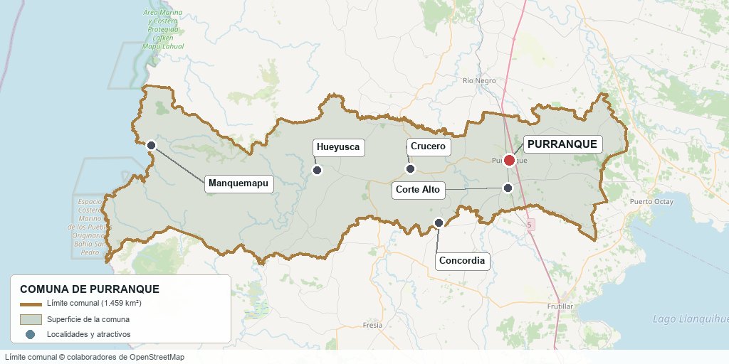
Commune boundary based on OpenStreetMap open data
§ 03 Location, Geography and Territory View
An east-west strip of 1,458.8 km² running from the central plain to the ocean.
The town of Purranque lies on the central plain of the province of Osorno, at 118 m above sea level, 43 km from Osorno and 69 km from Puerto Montt via the Ruta 5. From there the commune stretches westward: first the valley, with moraines and cones, then the Cordillera de la Costa (Coastal Range), and finally a narrow coastal plain facing the Pacific.
The commune strip: from the Ruta 5 valley to the Manquemapu coast
3.1 Two watersheds
The commune's waters drain into two basins. The valley drains north into the Bueno River basin: there flow the Negro River, the Blanco River and the streams that cross the town (Forrahue, Pichillaillay, Futallaillay). The coastal slope drains straight to the sea through the Hueyusca, Guayusca, De La Plata, Manquemapu, Quedal and San Carlos rivers.
Rivers with a stretch inside the commune (OpenStreetMap, mapped length)7 rows
| River | Watershed | Stretch in the commune |
|---|---|---|
| Hueyusca | Coastal | 27.8 km; continues toward Fresia |
| Guayusca | Coastal | 19.5 km; flows into the sea south of Manquemapu |
| De La Plata | Coastal | 14.9 km |
| Manquemapu | Coastal | 14.7 km; flows into the cove of the same name |
| Quedal | Coastal | 10.8 km |
| Blanco | Valley (Bueno basin) | 12.8 km |
| Negro | Valley (Bueno basin) | 10.3 km; continues north into the commune of Río Negro |
The valley streams matter more than they seem: the draft of the new zoning plan designates as flood-prone the river deposits of the Forrahue River and the Pichillaillay and Futallaillay streams, right at the edges of the town where parcel subdivision is expanding.
3.2 What lies inside and what does not
The commune's coastline is short: the Manquemapu, Panguirruca and Bahía San Carlos area and the mouth of the Guayusca. Caleta Cóndor, the Hueyelhue River and Punta Lobería are in Río Negro; Bahía Mansa and Maicolpué, in San Juan de la Costa. Lake Llanquihue, about 20 km from the town, belongs to Frutillar and Puerto Octay. Riachuelo is part of Río Negro and Tegualda of Fresia, even though real estate listings sometimes present them as "Purranque".
§ 04 Climate and Seasonality View
Purranque has a temperate rainy west-coast climate (Köppen Cfb), which becomes the colder Cfc on the heights of the Cordillera de la Costa. The weather station of the Dirección Meteorológica de Chile installed in the commune has only been operating since November 2023 and has no climate normals, so the official reference is Cañal Bajo, in Osorno, about 32 km to the north and in the same valley.
Rainfall: 1991–2020 climate normal for the Cañal Bajo station, Osorno (1,235.5 mm a year). Temperature: mean observed in 2025 at the same station, not a climate normal. June gets five times as much rain as January: winter means mud and waterlogged paddocks, and summer is what dictates irrigation and drinking water for livestock.
The 1991–2020 normal for Cañal Bajo totals 1,235.5 mm a year, with June as the wettest month (203.6 mm) and January as the driest (40.9 mm). A given year can depart widely from the average: in 2025 only 749 mm fell, 39 % below normal, with an almost dry autumn.
The mean temperature observed in 2025 was 11.8 °C, ranging from 16.4 °C in January to 6.4 °C in June. The coastal slope receives more rain than the valley because of the mountain range, but no data series has been published for the Purranque coast.
§ 05 History: A Century on a Timeline View
-
Before 1813
The Purranquiles
The territory is Huilliche, under the cacique Raylef, "cacique of the Purranquiles". The name comes from Purranquil, "land of reed beds": pu (plural) and ranquil (swamps or reed beds).
-
1813
The Dollinco estate
Camilo Santibáñez buys from Raylef the lands of the future Dollinco estate, which later pass to Félix Rosas Manrique de Lara.
-
1896
Lutheran settlers
A Lutheran community of German origin settles here. Its church on Las Heras street was not built until 1960.
-
1911
Villa Lo Burgos
On 18 April Tomás Burgos Sotomayor founds the town on land belonging to his wife, Sofía Rosas, where the new railway crosses the old Camino Real from Valdivia to Chiloé. The station opens that same year.
-
1915
Official recognition
A decree of 16 May, under the government of Juan Luis Sanfuentes, recognizes the town. In those years the wooden houses of the town center that still stand today are built.
-
1929
The fire
On 19 January a fire destroys most of the wooden buildings in the town center, including the parish church. The first fire brigade is born as a result.
-
1940
Branch line to Los Muermos
In September the railway branch line from Corte Alto to Los Muermos begins operating; for decades it carried the produce of Fresia and Los Muermos to the main line.
-
1941
The commune is born
Law No. 6,402, of 24 November, creates the commune of Purranque by separating it from Río Negro. The Molino San Pedro flour mill opens the same year.
-
1945
First hospital
On 7 October the first health facility opens, promoted by the Sociedad Hospital Purranque, founded in 1943.
-
1967
Zoning plan
The Commune Zoning Plan (Plan Regulador Comunal) is approved; with partial amendments, it is still in force.
-
1982
The branch line closes
The Corte Alto – Los Muermos branch line stops operating; there were occasional freight runs until 1990.
-
2008
Lafkenche Law
Law 20,249 creates the Indigenous Peoples' Marine Coastal Spaces; the communities of Manquemapu, Mahuidantu and Lafken Mapu (Bahía San Pedro) apply for their own off the commune's coast.
-
2005–2007
The last passenger train
The station is remodeled and the Victoria–Puerto Montt regional train returns in December 2005; the service is suspended in 2007. Since then the line has carried only freight.
-
2024
Hospital accreditation
The Hospital Dr. Juan Hepp Dubiau is accredited for the third time, now as a medium-complexity facility, valid until December 2027.
The history of Purranque is that of a railway station that became a dairy town. The commune was not born from a fort or a port, but from a crossroads in a humid valley that the railway made profitable: milk, wheat and timber left by rail, and the town grew up around it.
§ 06 Cultural Identity and Indigenous Peoples View
Almost a third of Purranque's population, 29.2 % (5,713 people, 2024 Census), identifies as belonging to an Indigenous people, above the regional average (26.6 %) and almost three times the national figure (11.4 %). They are Mapuche-Huilliche (Williche), present in the valley countryside and, above all, on the coast.
6.1 The Williche coast: Manquemapu and Mapu Lahual
Manquemapu is the southern end of the Lafken Mapu Lahual territory, "sea and land of alerces": some 60,000 ha of coastal forest home to ten Williche communities, about 300 families, spread across San Juan de la Costa, Río Negro and Purranque. Its 52 km main trail can only be traveled on foot. Families live from shingles made of dead alerce wood (the alerce has been a Natural Monument since 1977), artisanal fishing for conger eel, hake and loco (Chilean abalone), and gathering cochayuyo and luche seaweed.
Most of Mapu Lahual, including the Marine Coastal Protected Area (Decree 517 of 2005, between Punta Tiburón and Punta Lobería), lies in Río Negro. What does lie along Purranque's edge are the Indigenous Peoples' Marine Coastal Spaces (ECMPO) requested by the communities of Manquemapu, Mahuidantu and Lafken Mapu (Bahía San Pedro): five applications totaling 11,490.7 ha, according to the zoning plan report (2019). The Bahía San Pedro ECMPO has been granted and is managed by the Lafken Mapu community.
6.2 Festivals and heritage
The main festival is that of San Sebastián, on 20 January, a procession that draws thousands of pilgrims from across the region and whose devotion dates back to the first chapel, from 1924. In summer the municipality organizes a circuit of traditional country festivals that travels through the rural villages:
Circuit of traditional country festivals (calendar for one season; dates change every year)9 rows
| Locality | Festival | Period |
|---|---|---|
| Concordia | Rescatando Nuestras Tradiciones (Reviving Our Traditions) | Early January |
| Crucero | Fiesta de la Empanada (Empanada Festival) | Mid-January |
| La Poza | Traditional country festival | Late January |
| Los Ángeles | Food festival | Late January |
| Coligual | Fiesta del Artesano (Artisan Festival) | Early February |
| Los Riscos | Asado de Chivo (Goat Roast) | Mid-February |
| Colonia Zagal | Fiesta del Camino Real (Camino Real Festival) | Mid-February |
| Hueyusca | Traditional Country Festival | Late February |
| La Naranja | Fiesta del Cordero (Lamb Festival, closing event) | Early March |
The built heritage is in the town center: the railway station (1911), the Molino San Pedro flour mill (1941), the Lutheran Church (1960) and a series of wooden houses from 1915 to 1922 —Casa Aedo, Casa Álvarez Rosas or "de las Palomas", Casa Barrientos García, the Casa de la Cultura (formerly Casa Mutizabal) and Casa Yantani, belonging to a Lebanese family that arrived in 1910—. Several survived the 1929 fire, and the draft of the new zoning plan proposes protecting them as buildings of historic conservation value.
§ 07 Key Demographic Data View
Purranque is losing population: it went from 20,369 inhabitants in 2017 to 19,542 in 2024, 4.1 % fewer, while the region grew 7.4 % and the country 5.2 %. This is the demographic fact that most shapes the market: housing demand does not come from local growth but from buyers from elsewhere.
Demographic indicators (2024 Census, INE, via BCN Reporte Comunal 2026)8 rows
| Indicator | Purranque | Distinction |
|---|---|---|
| Population 2024 | 19,542 | 2017: 20,369 (−4.1 %) |
| Urban / rural population | 13,853 / 5,689 | Rural share 29.1 % · country 13.3 % |
| Women / men | 10,027 / 9,515 | Masculinity index 94.9 |
| Identification with Indigenous peoples | 29.2 % | Region 26.6 % · country 11.4 % |
| Born outside Chile | 1.2 % | Country 8.7 % |
| Aging index | 107.1 | 2017: 74.4 · country 79.0 |
| Average schooling | 9.0 years | Region 9.8 · country 10.4 |
| Total fertility rate (2023) | 1.17 | DEIS-MINSAL |
The urban population is concentrated in the town of Purranque and in Corte Alto (in 2017 together they had 14,388 people, 70.6 % of the commune). Outside them, the countryside lives in villages such as Crucero —363 inhabitants in 2017— and in scattered settlement.
§ 08 Economic and Socioeconomic Data View
In 2024 there were 1,759 companies registered in the commune (SII). Retail and wholesale trade is the sector with the most companies (537), but the one that departs most from the average is agriculture: 440 agricultural, livestock and forestry companies, 25 % of the total, whereas in the region that sector accounts for 11 % and in the country 6.3 %.
Companies and salaried workers by sector, 2024 (SII, via BCN 2026)9 rows
| Sector | Companies | Salaried workers |
|---|---|---|
| Agriculture, livestock, forestry and fishing | 440 | 1,766 (32 %) |
| Retail and wholesale trade | 537 | 968 |
| Public administration | — | 732 |
| Manufacturing | 138 | 519 |
| Administrative and support services | 52 | 468 |
| Education | — | 409 |
| Construction | 151 | 258 |
| Transportation and storage | 173 | 161 |
| Commune total | 1,759 | 5,514 |
Agriculture is the leading formal employer: 1,766 of the 5,514 reported salaried workers (32 %), compared with its 19 % share in the region. But its weight is falling: in 2013 the sector accounted for 54.6 % of a total of 7,241 workers. The sector remains first, but with fewer formal workers reported in the commune.
8.1 Poverty and municipal finances
Social and municipal indicators7 rows
| Indicator | Purranque | Source |
|---|---|---|
| Income poverty | 17.2 % | CASEN 2024 (region 16.5 %, country 17.3 %) |
| Multidimensional poverty | 17.4 % | CASEN 2024 (country 17.7 %) |
| People in households lacking basic services | 18.7 % | RSH, June 2026 |
| Total municipal revenue | M$ 9,177,414 | SINIM 2025 |
| Dependence on the Fondo Común Municipal (Municipal Common Fund) | 47.5 % | SINIM 2025 |
| Permanent own revenue | 27.8 % | SINIM 2025 |
| Property tax (municipal share) | M$ 791,386 | SINIM 2025 |
CASEN 2024 uses a new methodology and its figures are not comparable with those of 2022. What does set Purranque apart is the lack of basic services: almost one in five inhabitants lives in a household without piped drinking water, sewerage or with another deficiency of that kind, a trait typical of the scattered countryside.
§ 09 The Economic Engine: The Osorno Dairy Basin View
Purranque lives off milk. In 2022 the commune's producers delivered 125,167,032 liters to industry, 5.62 % of all the milk received in Chile, placing it fourth nationally (ODEPA and Consorcio Lechero, "Indicadores del Sector Lácteo 2022").
Communes with the most milk delivered to industry, 2022 (ODEPA / Consorcio Lechero)7 rows
| Rank | Commune | National share |
|---|---|---|
| 1 | Bueno River | 13.52 % |
| 2 | Puerto Octay | 10.07 % |
| 3 | Osorno | 9.72 % |
| 4 | Purranque | 5.62 % (125.2 million liters) |
| 5 | Los Ángeles | 5.56 % |
| 6 | La Unión | 5.24 % |
| 7 | Río Negro | 5.01 % |
Those liters are delivered by 77 producers, 3.8 % of the country's dairy farmers who sell to industry. On average that is 1.6 million liters per producer per year: large, technology-intensive farms with milking parlors and improved pastures. The 2025 figures confirm that the Osorno basin still concentrates the country's dairy farming, but they do not publish Purranque's figure separately.
9.1 The value chain within the commune
- Lactosueros Industriales S.A.: dairy processing plant, expanded in 2013 with an investment of US$ 3.8 million; it has a treatment plant with biogas.
- Feria de Ganaderos Osorno (Fegosa): livestock auction yard in Purranque.
- INIA La Pampa: experimental center of the Instituto de Investigaciones Agropecuarias (Agricultural Research Institute) near the town, known for its annual Angus bull auction.
- Universidad de Chile: the Faculty of Agricultural Sciences has a dairy farm in the commune.
- Bayas del Sur S.A.: plant in the commune (investment of US$ 1 million, 2009).
- Piscicultura Hueyusca: freshwater fish farm supplying salmon farming, on the coastal slope.
9.2 The countryside according to the latest census with commune-level data
The commune-level results of the 2021 Agricultural Census could not be consulted for this edition. The 2007 census recorded 1,146 farms covering 144,239 ha, 98,399 cattle and 79 forestry holdings with 62,738 ha, concentrated in the Cordillera de la Costa. On agricultural and livestock farms, pastures occupied 62.6 % of the land and crops 12 %.
Geography shapes production: the central valley has class I to III soils, is highly subdivided and concentrates dairy and livestock farming; from the foothills of the Cordillera de la Costa toward the sea there is almost no subdivision, and native forest, eucalyptus and pine plantations and the economy of the coastal communities predominate.
§ 10 Real Estate Market View
Asking prices published in November 2026. They are for reference only and do not constitute an appraisal.
The sample consists of 78 unique listings from Yapo for the commune, read on 5 November 2026 and cleaned: duplicates were removed, as were properties that, according to their description, are in Riachuelo (Río Negro), Tegualda (Fresia), the outskirts of Puerto Octay or on the boundary with Frutillar. These are asking prices, not closing prices, calculated with a UF of $41,270.
Asking prices by property type within the commune (Yapo, November 2026)7 rows
| Type | N | Median | Range |
|---|---|---|---|
| 5,000 m² parcel without a house (valley) | 12 | $34.3 M (≈ UF 831) | $18 – 65 M |
| Land of 1.4 to 4 ha | 7 | $26.7 M per ha | $20 – 33.6 M per ha |
| Valley farming and livestock property (>50 ha) | 4 | $16.3 M per ha | $12 – 20.5 M per ha |
| Forestry property | 2 | — | $5.0 and $9.7 M per ha |
| Property in Hueyusca / Cordillera de la Costa | 2 | — | $2.9 and $3.9 M per ha |
| House with parcel (rural) | 6 | $175 M | $113.5 – 320 M |
| Urban house (Purranque and Corte Alto) | 12 | $85 M | $45 – 350 M |
10.1 Three subdivision hotspots
- Ring around the town, Corte Alto and Coñico (median ≈ $36 M per 5,000 m², N=6): gated condominiums, subdivisions such as Praderas de Purranque and Laderas del Sur, and the Dollinco estate next to Corte Alto. It is the most expensive hotspot because of its proximity to services and the Ruta 5.
- U-900 corridor toward Crucero (median $30 M, N=3): 5,000 m² subdivisions on a paved road; one listing offers an entire property already subdivided into 67 parcels for UF 25,000. Parcels of 1.4 to 4 ha in Los Riscos, Colonia Ponce, Concordia and Maipué ask between $20 and $34 M per hectare.
- Coast of Bahía San Pedro and San Carlos (UF 980 to 1,050 per 5,000 m², N=2): subdivisions with sea views and native forest, far from town and with the final stretch on gravel and dirt.
For farms, the valley makes the difference: farming and livestock properties on asphalt or on the Crucero–Hueyusca road ask between $12 and $20.5 M per hectare; a 340 ha property 4 km from the asphalt in Hueyusca is offered at less than $3 M per hectare. In town, the only central lot listed (800 m² on a corner) asks about UF 9 per m².
10.2 Produncan properties in the commune
Properties listed by Produncan Lands within the commune boundary (November 2026)5 rows
| Property | Sector | Area |
|---|---|---|
| Campo Fundo Camarones | Camarones, coastal slope | 476 ha |
| Farm in Hueyusca | Hueyusca | 345 ha |
| La Poza forestry property | La Poza, Hueyusca sector | 160.86 ha |
| Farm in Alto Palomar | El Palomar, between the town and Crucero | 7 ha |
| Parcel in Maipué | Maipué, near Concordia | 4.12 ha |
§ 11 Land-Use Planning in Purranque View
Purranque is governed by a Commune Zoning Plan (Plan Regulador Comunal) approved in 1967, which is still in force. It has had partial amendments: a sectional plan in 1978, the Centro Norte sector in 1996, the La Colmena sector in 2001 —the only expansion of the urban boundary, to the west— and changes to the ordinance in 2002. Corte Alto has not been updated since 1967.
Current and proposed urban area (Report on the draft PRC, November 2019)4 rows
| Polygon | In force (1967 and amendments) | Draft plan |
|---|---|---|
| Town of Purranque | 411.2 ha | 628.6 ha |
| Población Carrasco (east of the Ruta 5) | 20.3 ha | 80.2 ha |
| Corte Alto | 228.9 ha | 237.6 ha |
| Total | 660.4 ha | 946.4 ha (+43 %) |
The draft update (report of November 2019, with a strategic environmental assessment) expands the town to the west and east, creates 21 zones —mixed-use, residential, a business facilities area, the railway strip and a special zone for the Corte Alto airfield— and proposes 14 buildings of historic conservation value. As of 2025 SINIM was still reporting the 1967 plan as the one in force: confirm with the Dirección de Obras (Municipal Works Department) which instrument applies on the date of your purchase.
11.1 Risks and restrictions proposed by the new plan
- AR1, flood-prone zones: river deposits of the Forrahue River and the Pichillaillay and Futallaillay streams, and low-lying areas that become waterlogged.
- AR2, landslides: alluvial deposits with slopes over 12° and hillsides over 35°.
- Non-buildable zones: the railway strip, high-voltage power lines and the approach cones of the Corte Alto airfield.
11.2 Outside the urban boundary
Only the town (with Carrasco) and Corte Alto have an urban boundary. Crucero, Concordia, Hueyusca, Coligual and the rest of the commune are rural: there, subdivision is governed by DL 3,516 (lots of at least 0.5 ha with an SAG certificate), and any construction not intended for the property's agricultural use requires a favorable report under Article 55 of the Ley General de Urbanismo (General Urban Planning Law). Crucero, with its own sewerage network and treatment plant, functions as a town but is legally countryside.
On the coast, the commune is part of the "Cordillera de la Costa" priority site for conservation (316,188 ha spread across five communes), which requires environmental assessment of certain projects, and it concentrates the Indigenous lands and ECMPO described in section 6. The only public road to the coastline is the U-900.
§ 12 Neighbourhoods and Areas View
Center of Purranque · -40.9128, -73.1582
Sectors of the commune and their character8 rows
| Sector | Character | Suited to |
|---|---|---|
| Centro and Barrio Estación | Original town core between the station and the Ruta 5; shops, services and wooden houses from 1915–1922 | Retail, urban housing |
| Northern and western housing estates | Villa Los Lagos, Los Volcanes, Ruca Peñi, La Colmena and Los Alerces: social and middle-class housing | First home, rental |
| Carrasco and Dollinco | East of the Ruta 5; Dollinco lies partly outside the urban boundary | Homes with more land |
| Corte Alto | Second urban area, 4 km to the south: station, airfield, CECOSF and lifestyle-parcel subdivisions on the Dollinco estate | Parcel close to services |
| Crucero and El Palomar | First village toward the coast along the U-900, with its own sewerage; 5,000 m² subdivisions | Lifestyle parcel 10 minutes from town |
| Concordia, Maipué and Colonia Ponce | Dairy valley to the south and east, with paved roads (U-950-V, U-951) | Productive farmland, parcels of 1 to 4 ha |
| Hueyusca, Coligual and Colonia Zagal | Foothills of the Cordillera de la Costa: livestock, forestry and communities | Large properties at a lower price |
| Manquemapu and San Carlos | Williche coast, forest and coves; access on gravel and dirt | Conservation, nature tourism |
§ 13 Basic Services, Utilities and Digital Connectivity View
Basic services by sector4 rows
| Service | Town and Corte Alto | Countryside |
|---|---|---|
| Drinking water | Suralis network (formerly Essal) | APR in Crucero, Coligual, Hueyusca, Concordia, Colonia Ponce and La Naranja; shallow dug wells in San Pedro, Collihuinco, Colonia Zagal and Manquemapu |
| Sewerage | Suralis network | Crucero has its own network and plant; elsewhere, septic tanks |
| Electricity | Saesa | Saesa and the Crell cooperative; confirm the utility company for each sector |
| Phone and internet | Mobile and landline | Patchy signal: several rural health posts only have satellite phones |
The indicator that sums up the rural problem comes from the Registro Social de Hogares (Social Household Registry): 18.7 % of people live in households lacking basic services. Even in the urban area there were blocks in Purranque, Corte Alto and Barrio Estación supplied by wells or shallow dug wells in the 2017 Census.
On electricity, in 2023 the Superintendency formally notified Crell and Saesa over prolonged outages in rural sectors of the region after a storm. In 2023 Crell ranked 21st out of 26 in the SEC service quality ranking.
§ 14 Health View
The commune has its own hospital: the Hospital Dr. Juan Hepp Dubiau, part of the Servicio de Salud Osorno, accredited as a medium-complexity facility (Superintendencia de Salud, valid until 16 December 2027). It had previously been accredited twice as low-complexity; in 2019 it began performing higher-complexity surgeries, and the Ministry of Health presented it as the first medium-complexity hospital in the province outside the Hospital Base de Osorno.
Health network in the commune (municipal Health Plan 2025 and DEIS)7 rows
| Facility | Location | Care |
|---|---|---|
| Hospital Dr. Juan Hepp Dubiau | Town of Purranque | Medium complexity, emergency |
| CESFAM Purranque | Town | Monday to Saturday |
| CECOSF Barrio Estación | Town | Primary care |
| CECOSF Corte Alto | Corte Alto | Primary care |
| Rural health posts with daily care | Crucero, Coligual, Hueyusca, Concordia | Paramedic technician and visiting rounds |
| Health posts with periodic rounds | Colonia Ponce, Collihuinco, La Naranja, San Pedro | Medical rounds |
| Rural medical stations | Manquemapu, Colonia Zagal | Rounds |
High-complexity care is at the Hospital Base San José de Osorno, 43 km away via the Ruta 5. Manquemapu, on the coast, only has a rural medical station and is waiting for its own health post.
§ 15 Education View
The commune has 23 schools (13 municipal and 10 subsidized private, none fully private) with 4,262 students in 2025. 71 % study at subsidized schools.
SIMCE 2025 results (preliminary)6 rows
| Grade and test | Purranque | Region | Country |
|---|---|---|---|
| 4th grade · Reading | 279 | 275 | 276 |
| 4th grade · Mathematics | 255 | 259 | 262 |
| 8th grade · Reading | 231 | 236 | 238 |
| 8th grade · Mathematics | 242 | 255 | 258 |
| 10th grade (2° medio) · Reading | 244 | 245 | 250 |
| 10th grade (2° medio) · Mathematics | 247 | 255 | 263 |
The commune outperforms the region and the country in 4th-grade Reading and falls below them in the rest, with the largest gap in Mathematics in 8th grade and 10th grade (2° medio). Technical-vocational provision is minimal: 96 students in 2025. Schools include the Liceo Tomás Burgos (municipal), the Instituto Alemán Purranque and the Colegio Preciosa Sangre.
There is no higher education campus in the commune. The nearest are in Osorno: Universidad de Los Lagos, INACAP, Santo Tomás and AIEP.
§ 16 Coast, Forest and Natural Surroundings View
Purranque has no state parks or reserves (SNASPE). Its natural heritage lies in the Cordillera de la Costa: coastal Valdivian forest, alerce and rivers that flow straight to the sea. The commune is part of the "Cordillera de la Costa" priority site and has twelve private conservation initiatives registered in the Biodiversity Information System of the Ministry of the Environment, two of them on the coast (Hijuela 7 in San Carlos and Hijuela N.º 1 Manquemapu San Antonio) and one devoted to agritourism (Las Bandurrias).
The commune's own coastline consists of the coves of Manquemapu, Panguirruca and Bahía San Carlos and the mouth of the Guayusca River: the commune's only stretch of sea, with native forest on the slopes that run down to the shore. Near Corte Alto, the Collinco–Los Robles estate, owned by CODEFF, is another example of private conservation in the valley.
§ 17 Connectivity and Transportation View
Purranque between Osorno and Puerto Montt, on the Ruta 5
Road distances from the main square of Purranque (OSRM on the OpenStreetMap network, without traffic)8 rows
| Destination | Distance | Approximate time |
|---|---|---|
| Río Negro | 22 km | — |
| Frutillar | 27 km | — |
| Hueyusca | 36 km | ~40 min |
| Osorno (main square) | 43 km | ~33 min |
| Cañal Bajo airfield (Osorno) | 45 km | ~37 min |
| El Tepual Airport (Puerto Montt) | 68 km | ~60 min |
| Puerto Montt (main square) | 69 km | ~52 min |
| Manquemapu (coast) | 85 km | ~2 h 30, final stretch on dirt road |
17.1 The road to the coast: the U-900
Route U-900 leaves the town heading west and is the only public road to the coastline of the commune. According to OpenStreetMap, it is paved for about 39 km, to just beyond Hueyusca; then come about 20 km of gravel and 16 km of dirt to the Manquemapu and Bahía San Carlos area. A four-wheel-drive vehicle is recommended for the final stretches, especially in winter. The official condition of each stretch should be confirmed with Vialidad (the national roads authority).
17.2 Railway and buses
The southern railway line passes through Purranque and Corte Alto, but there has been no passenger train since 2007; only freight runs. Buses leave from the terminal on Eleuterio Ramírez street, with frequent services to Osorno and Puerto Montt via the Ruta 5.
§ 18 Tourism: Development, Attractions and Things to Do View
Purranque is not an established tourist destination and has no published tourism development plan. What it offers is rural and cultural, and the greatest potential lies on the coast.
Attractions within the commune6 rows
| Attraction | What it is | When |
|---|---|---|
| Fiesta de San Sebastián | Patron saint procession that draws thousands of pilgrims from across the region | 20 January |
| Traditional festival circuit | Nine rural festivals: empanadas in Crucero, artisans in Coligual, lamb in La Naranja | January to March |
| Manquemapu and Mapu Lahual | Williche cove, southern gateway to the Mapu Lahual territory; community-based tourism and trails | Summer |
| Bahía San Carlos and Panguirruca | Beaches and coves of the commune's coastline | Summer |
| Historic town center | 1911 station, Molino San Pedro, Lutheran Church and wooden houses from 1915–1922 | Year-round |
| Agritourism | Visits to dairy farms and rural trails, with offerings still scattered | Spring and summer |
In Manquemapu, a community tourism group maintains trails together with residents of San Pedro, San Carlos and Panguirruca. It is advisable to arrange the visit in advance: there are no formal services or stable signal, and the road depends on the weather.
§ 19 Everyday Life, Sport and Practical Information View
- Municipality: Mayor Alicia Villar Vargas (2024–2028), elected with 5,519 votes; six council members.
- Banks: BancoEstado with a branch on Aníbal Pinto street; for larger transactions and major shopping, Osorno.
- Culture: Municipal Theater, Casa de la Cultura, exhibition hall and Public Library.
- Sports: Estadio Centenario, Estadio Municipal and a public gymnasium; amateur soccer with clubs in the town, Corte Alto and Crucero.
- Media: local FM radio stations and the Osorno press (El Austral de Osorno, Radio Antillanca).
- Transportation: bus terminal on Eleuterio Ramírez street.
Safety: reported crimes per 100,000 inhabitants, 2025 (CEAD, via BCN 2026)2 rows
| Offense | Purranque | Region | Country |
|---|---|---|---|
| Crimes against the life or physical integrity of persons | 1,127.2 | 1,127.5 | 1,003.2 |
| Domestic violence | 616.1 | 870.2 | 585.1 |
Crimes against persons are at the regional average and somewhat above the national one; domestic violence is well below the region.
§ 20 Territorial Analysis: Strengths, Challenges and Opportunities View
- One of the five largest dairy communes in Chile: valley land has productive value, not just lifestyle value.
- Ruta 5, a medium-complexity hospital and two airports less than an hour away.
- Three land markets in one commune: productive valley, parcels near town and coast.
- A coast with Williche identity and native forest, without large-scale real estate development.
- Declining population (−4.1 % between 2017 and 2024) and aging: more older adults than children.
- Zoning plan from 1967; the update has gone unapproved for years.
- Uncertain rural water supply: shallow dug wells, tanker trucks in summer and almost one in five inhabitants lacking basic services.
- Average schooling of 9 years and SIMCE results below the region in most tests.
- A single road to the coast, with more than 35 km of gravel and dirt.
- Lifestyle parcels in the urban ring and along the U-900 corridor, with urban services and the Ruta 5 minutes away.
- Dairy and livestock farms with a leasing market and buyers from within the sector.
- Community-based and nature tourism in Manquemapu, coordinated with the communities.
- Expansion of the urban boundary proposed in the draft plan, adding some 286 ha.
- Flooding along the banks of the Forrahue, Pichillaillay and Futallaillay streams.
- Milk prices and industry concentration: the valley depends on a single sector.
- Summer droughts like that of 2025, with 39 % less rain than normal.
- Indigenous lands and coastal spaces on the coast: purchases that cannot be made or that require consultation.
Purranque: Territory, Connectivity and Opportunities
Purranque brings together something that is not easy to find: genuinely productive farmland, on the Ruta 5, half an hour from Osorno and an hour from Puerto Montt, with a still untouched coast on the other side of the mountain range. For the investor, the key is knowing which of its three territories they are looking at, and what water, what road access and what regulations the property has.
At Produncan Lands we know this territory and its opportunities. Our work is to connect properties with people looking to invest, live and develop new projects in southern Chile, offering our experience, local knowledge and commercial reach.
We invite you to explore our properties in Purranque and throughout southern Chile, and to entrust Produncan Lands with the sale of your property.
View properties at Produncan Lands§ 22 Sources and Methodology Note View
22.1 Sources by scope
Sources consulted9 rows
| Scope | Source |
|---|---|
| Demographics, economy, education, safety | BCN, Reporte Comunal Purranque 2026 (2024 Census, CASEN 2024, SII 2024, SINIM 2025, SIMCE 2025, CEAD 2025) |
| Dairy farming | ODEPA, Indicadores del Sector Lácteo 2022 |
| Zoning plan, industry and coast | Report on the draft update of the Purranque PRC, 2019 |
| Health and rural services | Municipalidad de Purranque, Plan de Salud 2025; Superintendencia de Salud, registry of healthcare providers |
| History and heritage | Municipalidad de Purranque, Plan Municipal de Cultura 2025–2028 |
| Climate | DMC, Cañal Bajo station (Osorno), 1991–2020 precipitation normal and temperatures observed in 2025 |
| Mapu Lahual | Presentation by the Manquemapu community, CBD 2016; Decree 517/2005, AMCP Lafken Mapu Lahual |
| Commune boundary, rivers and distances | OpenStreetMap (relation 1795811) and route calculation with OSRM, November 2026 |
| Real estate market | Yapo, real estate in Purranque, 78 unique listings, 5 November 2026; properties listed by Produncan Lands |
22.2 Methodology note and data currency
- The precipitation normal is from the Cañal Bajo station, in Osorno; the monthly temperatures are those observed in 2025, not a climate normal. The Purranque station does not have a long enough data series.
- The commune-level results of the 2021 Agricultural Census could not be consulted; the figures for farms and cattle are from the 2007 census.
- The number of hospital beds, sewerage coverage, fiber-optic availability, the total number of APR systems and the dominant soils (CIREN) could not be verified and were therefore left out.
- The official area is 1,458.8 km² (BCN); the map uses the OpenStreetMap boundary, which measures about 1,442 km².
- The status of the new zoning plan should be confirmed with the Dirección de Obras: as of 2025 the 1967 plan was in force.
- Real estate market price ranges are for reference only, calculated from asking prices, and do not constitute an appraisal. Each property must be assessed individually.
- This document does not constitute legal or tax advice.
- Closing date of this edition: November 2026. It is recommended to review the indicators in sections 7, 8 and 10 annually.
Territorial reference document prepared by Produncan Lands. It combines official information (INE, BCN, SII, SINIM, MINEDUC, MINSAL, ODEPA, DMC) with local market knowledge so that anyone —resident, visitor, investor or buyer— can understand Purranque in depth before making a decision.