
Aysénthe commune of the fjord, the channels and San Rafael Lagoon
History, Territory and Investment Opportunities
AYSÉN, FROM PIER TO FJORD
Before the settlers, these channels belonged to the Chonos, canoe-going people who lived off shellfish, sea lions and tree bark, and who left their language only in the names of the islands. In 1870 the corvette Chacabuco, under Enrique Simpson, sailed up the Aysén estuary looking for a passage to the interior; the river that came down from the cordillera took his surname, and the port that was to come took the name of the ship.
In 1903 the Sociedad Industrial de Aysén (Aysén Industrial Society) opened a trail from the pampas in the east to the mouth of the river and built a pier there to ship out wool. Puerto Aysén grew up beside those warehouses, built of wood and zinc, with Chilote settlers (from Chiloé) who arrived by launch and stayed to clear the valley. The river, which had been its reason for existing, filled with sediment and left it without ships: in the 1960s the port moved down to Chacabuco and the city was left connected to it by a suspension bridge.
Today the commune looks at the water differently. In the Moraleda channels the salmon cages float, and in Puerto Aguirre the boats still go out for hake; the catamaran leaves Chacabuco for the icebergs of San Rafael Lagoon. More than two thousand millimeters of rain fall each year, the forest reaches down to the shore, and valley land —in Los Palos, in the Simpson, in Mañihuales— remains scarce, wet and green.
Version 1.0 · Expanded edition · November 2026
The Commune at a Glance
The essential facts about Aysén in a single view. Each figure is developed in the corresponding section.
Administrative identification and reference data11 rows
| Fact | Detail |
|---|---|
| Region / province | Aysén del General Carlos Ibáñez del Campo Region · Aysén Province |
| Commune code (CUT) | 11201 |
| Commune capital | Puerto Aysén, at the mouth of the Aysén River, at 10 m above sea level |
| Other localities | Puerto Chacabuco, Villa Mañihuales, Puerto Aguirre and Caleta Andrade (Huichas Islands) |
| Neighboring communes | Guaitecas and Cisnes (north), Coyhaique, Río Ibáñez and Chile Chico (east), Tortel (south), Pacific Ocean (west) |
| Mayor | Luis Martínez Gallardo; six council members |
| Demonym | aysenino, aysenina |
| Rural population | 14.7 % (2024 Census); region 23.0 % |
| Indigenous peoples | 34.7 % identify as Indigenous (2024 Census); country 11.4 % |
| Zoning plan | Puerto Aysén–Puerto Chacabuco Interurban Zoning Plan (1999); update pending |
| Protected areas | Laguna San Rafael National Park, Río Simpson National Reserve (in part) and Las Guaitecas National Reserve (in part) |
Overview
Aysén is a commune of 23,170 inhabitants (2024 Census) spread across an enormous territory: 29,796 km², almost twice the size of the Santiago Metropolitan Region. But almost all of that territory is water, rock, ice and forest. 72 % of the population lives in a single city, Puerto Aysén (16,710 people), and the rest is divided among Villa Mañihuales, Puerto Chacabuco and Puerto Aguirre.
The commune has three parts. The Aysén River valley, between Puerto Aysén, Chacabuco and Mañihuales, is the inhabited part, with roads, services and the little flat land there is. The channels, from the Moraleda channel to the Chonos Archipelago, are the territory of salmon farming and artisanal fishing, with Puerto Aguirre as the only town. The south, from the fjords to the Northern Patagonian Ice Field, is almost entirely Laguna San Rafael National Park.
What sustains the commune is the sea: salmon farming, the port of Chacabuco and fishing. The agriculture, livestock, forestry and fishing sector is the largest formal employer, and aquaculture concession license fees are the municipality's largest own-source revenue, ahead of property taxes and commercial licenses.
For anyone considering a purchase, Aysén offers parcels in the wet valley of Los Palos, the Simpson, Bahía Acantilada and Route 240; large farms at low prices per hectare, especially toward the fjords and in Mañihuales; and properties with sea, river or lake frontage, which are the most sought after. In return, the land comes with three conditions that are not negotiable: it rains all year, the urban regulations are out of date, and a good part of the territory is protected.
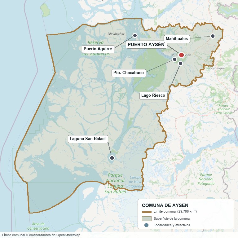
Commune boundary according to OpenStreetMap open data
§ 03 Location, Geography and Territory View
From the Aysén River valley to the Chonos Archipelago and the Northern Patagonian Ice Field.
Puerto Aysén lies at the mouth of the Aysén River, at the head of the fjord of the same name, 65 km from Coyhaique. The river is formed by the waters of the Mañihuales and the Simpson, which flow down from the east; the Simpson runs alongside Route 240 between the two cities. To the west, the Aysén fjord opens onto the Moraleda channel, which separates the mainland from the Chonos Archipelago.
The Aysén fjord, the Simpson valley and the channels as far as Puerto Aguirre
3.1 Four landscapes
Main units of the commune's territory4 rows
| Unit | What is there | Land use |
|---|---|---|
| Aysén and Simpson valley | Puerto Aysén, Chacabuco, El Balseo, Riesco, Los Palos and Yulton lakes | City, parcels, livestock, tourism |
| Mañihuales valley | Villa Mañihuales and the Carretera Austral (Route 7), to the northeast | Livestock, farms |
| Channels and archipelago | Moraleda channel, Huichas Islands (Puerto Aguirre, Caleta Andrade), Melchor, Traiguén and the Chonos | Salmon farming, fishing, reserves |
| Southern fjords and ice | Exploradores Bay, Hudson volcano, San Rafael Lagoon and Glacier, Northern Patagonian Ice Field | National park |
The Hudson volcano is inside the commune; the Macá and Cay volcanoes, which can be seen from the channels, are in Cisnes. The Liquiñe-Ofqui fault system runs through the territory from north to south and explains the 2007 fjord earthquakes (section 5).
3.2 What lies inside and what does not
Several things associated with Aysén lie in other communes. Puerto Cisnes, Puerto Gaviota and Magdalena Island belong to Cisnes; Villa Ortega, Lake Elizalde and Seis Lagunas, to Coyhaique; Puerto Ingeniero Ibáñez and Puerto Río Tranquilo, to Río Ibáñez. The Exploradores Glacier and Mount San Valentín, which are visited from Río Tranquilo, lie outside Aysén: the OpenStreetMap boundary places them in Chile Chico. By contrast, Exploradores Bay, on the coast, and San Rafael Lagoon and Glacier do belong to Aysén.
§ 04 Climate and Seasonality View
Puerto Aysén has a temperate rainy climate with no dry season (Köppen Cfb). The reference station is Puerto Aysén Ad., operated by the Dirección Meteorológica de Chile (Chilean Meteorological Directorate), next to the city's airfield, with a published 1991–2020 normal.
1991–2020 normal for the Puerto Aysén Ad. station of the Dirección Meteorológica de Chile: 2,255.6 mm a year and a mean of 9.5 °C. There is no dry month: February, the least rainy, totals 127.7 mm, more than falls in a year in Copiapó. What changes between seasons is the cold, not the rain.
The normal adds up to 2,255.6 mm a year, with May and June as the rainiest months (more than 250 mm each) and February as the least rainy (127.7 mm). It rains more than 1 mm on about 178 days a year, almost one day in two. The figures of 2,900 mm or more that circulate correspond to older normals; the airfield's long series shows a downward trend.
The mean annual temperature is 9.5 °C: January averages 14.2 °C, with highs of 21 °C, and July 4.3 °C, with average lows close to zero. Toward Mañihuales, farther inland, winters are colder and somewhat drier; in the channels and the Huichas Islands, they are milder and windier.
§ 05 History: From the Pier to the Salmon Port View
-
Before 1800
The Chonos
The channels of what is now the Chonos Archipelago are the territory of nomadic canoe-going people who live from fishing, shellfish and marine hunting. They disappear as a people through intermarriage and mission relocations; their language survives in place names.
-
1786–1793
José de Moraleda
The Spanish pilot surveys the archipelagos between Chiloé and the Chonos. The channel that separates the islands from the mainland bears his name.
-
1870–1871
The corvette Chacabuco
Enrique Simpson explores the Aysén fjord as an entrance to the interior and describes San Rafael Lagoon again. The Simpson River bears his surname and Puerto Chacabuco the name of his ship.
-
1903
Sociedad Industrial de Aysén
It is incorporated on 14 October with capital from Magallanes. It opens a trail from the pampas in the east to the Aysén estuary and sets up the pier that will give rise to the city, with regular service to Puerto Montt.
-
1927–1928
Capital of the Territory
DFL (decree with force of law) 8,582 creates the Territory of Aysén with its capital at Puerto Aysén, which is recognized as a city in 1928. Sources differ on the exact date (January or May).
-
1959
San Rafael Lagoon
Laguna San Rafael National Park is created. Law 13,375 creates the department of Coyhaique.
-
1960s
The river silts up
Sediment from the Aysén River prevents deeper-draft ships from entering, and the port moves to Puerto Chacabuco, 15 km to the west.
-
1968
Presidente Ibáñez Bridge
The suspension bridge, about 210 m long, is inaugurated over the Aysén River, linking the city with the road to Chacabuco. It is a Monumento Histórico (National Historic Monument).
-
1979
Biosphere Reserve
UNESCO declares the San Rafael Lagoon area a Biosphere Reserve.
-
1999
Río Simpson and the zoning plan
The Río Simpson National Reserve is created, between Aysén and Coyhaique, and the Puerto Aysén–Puerto Chacabuco Interurban Zoning Plan is approved.
-
2001–2003
Alumysa
Noranda presents an aluminum smelter in Puerto Chacabuco with three hydroelectric plants. Faced with opposition, it withdraws the environmental impact study in August 2003.
-
2007
Fjord earthquakes
After an earthquake swarm that began in January, on 21 April an Mw 6.2 earthquake detaches 22.4 million m³ of rock at Punta Cola. The tsunami in the fjord leaves 10 victims.
-
2012
“Your problem is my problem”
The Social Movement for Aysén protests the cost of fuel and the neglect by the State; the Presidente Ibáñez Bridge is the center of the blockades and clashes of February and March.
-
2017
New hospital
The new Puerto Aysén Hospital, of 15,000 m² and 56 beds, begins operating.
-
2025
Coastal space rejected
The regional coastal-border commission rejects the application for the Indigenous coastal space “Islas Huichas”, of about 394,000 ha in the commune's channels.
The history of Aysén is that of a city that was born looking at the river and ended up looking at the sea. It was the gateway of colonization, the capital of the territory until Coyhaique grew larger, and it lost its port when the river silted up. Salmon farming, since the 1990s, gave it an engine again and turned it once more into a commune of channels.
§ 06 Cultural Identity and Indigenous Peoples View
A 34.7 % of Aysén's population (8,047 people, 2024 Census) identify as belonging to an Indigenous people, above the regional average (29.0 %) and three times the national figure (11.4 %). The census does not publish a breakdown by people at the commune level; in the region, 95 % of those who identified as Indigenous in 2017 were Mapuche, and only 117 people were Kawésqar.
The explanation lies in how the area was settled: Puerto Aysén and the Huichas Islands filled up with Chilote settlers, of Huilliche descent, who arrived by launch from the late 19th century to work at the Sociedad Industrial, the sawmill and in fishing. The Chonos, the original canoe-going people of these channels, are not a census category.
6.1 Two cultures in one commune
In the valley, the culture is settler and cattle-ranching: the horse, the hearth fire, firewood and the country life of Mañihuales and El Balseo, akin to that of Coyhaique. On the Huichas Islands, the culture is seafaring: Puerto Aguirre and Caleta Andrade live from artisanal fishing for hake and conger eel, from shellfish and, increasingly, from services to salmon farming.
6.2 The Islas Huichas coastal space
In 2017 the Antünen Rain community applied for an Espacio Costero Marino de Pueblos Originarios (ECMPO), “Islas Huichas” (Coastal Marine Space for Indigenous Peoples) of about 394,000 ha, which covered a good part of the commune's channels and overlapped with more than 259,000 ha of protected areas. The regional coastal-border use commission rejected it unanimously on 9 December 2025; in February 2026 appeals against that rejection were filed. While an application is being processed, Law 20,249 suspends new concessions in the requested area.
§ 07 Key Demographic Data View
Aysén lost population between the last two censuses: it went from 23,959 inhabitants in 2017 to 23,170 in 2024, a 3.3 % decline, while the region fell 2.3 % and the country grew 5.2 %. The drop was almost entirely men: 1,197 fewer men and 408 more women, and the masculinity index fell from 113.2 to 98.9.
Demographic indicators (2024 Census, INE, via BCN Reporte Comunal 2026)8 rows
| Indicator | Aysén | Distinction |
|---|---|---|
| Population 2024 | 23,170 | 2017: 23,959 (−3.3 %) |
| Urban / rural population | 19,764 / 3,406 | Rural share 14.7 % · region 23.0 % |
| Women / men | 11,648 / 11,522 | Masculinity index 98.9 (2017: 113.2) |
| Identification with Indigenous peoples | 34.7 % | Region 29.0 % · country 11.4 % |
| Born outside Chile | 3.1 % | 2017: 1.5 % · country 8.7 % |
| Aging index | 61.6 | 2017: 36.9 · country 79 |
| Average schooling | 9.6 years | Region 9.9 · country 10.4 |
| Total fertility rate (2023) | 1.29 | DEIS-MINSAL |
Population by locality (INE, 2017 and 2024 Censuses, via citypopulation.de)4 rows
| Locality | 2017 | 2024 |
|---|---|---|
| Puerto Aysén | 17,508 | 16,710 |
| Villa Mañihuales | 1,561 | 1,528 |
| Puerto Chacabuco | 1,239 | 1,043 |
| Puerto Aguirre | 539 | 497 |
The four localities add up to 85 % of the commune. All of them lost inhabitants; Puerto Aguirre is the one that has fallen most over the long term (766 people in 2002). The loss of young men is consistent with an industry that rotates its staff and with workers who, counted in the commune in 2017, now live in Coyhaique or in Los Lagos.
§ 08 Economic and Socioeconomic Data View
In 2024 there were 2,675 companies domiciled in the commune (SII), 21 % of those in the region. Retail and wholesale trade is the sector with the most companies (753), followed by transportation (306) and by agriculture, forestry and fishing (277). But the sector that provides the most formal employment is the last of these.
Companies and salaried workers by sector, 2024 (SII, via BCN 2026)9 rows
| Sector | Companies | Salaried workers |
|---|---|---|
| Agriculture, livestock, forestry and fishing | 277 | 1,553 (24 %) |
| Retail and wholesale trade | 753 | 1,138 |
| Administrative and support services | 132 | 810 |
| Transportation and storage | 306 | 795 |
| Education | — | 531 |
| Accommodation and food services | 233 | 433 |
| Construction | 201 | 425 |
| Manufacturing | 260 | 307 |
| Commune total | 2,675 | 6,551 |
The 1,553 workers in the agriculture-forestry-fishing sector are 47.5 % of all those in the region in that sector, and rose from 1,165 in 2022. In the commune, that sector is mostly aquaculture and fishing. The figure understates real employment: the SII counts each worker in the commune of their employer's registered address, and the large salmon companies that operate in the channels of Aysén file from Puerto Montt. The drop in the total between 2023 and 2024 (from 7,237 to 6,551) comes almost entirely from public administration, due to the transfer of education to the Servicio Local (Local Education Service), not from job losses.
8.1 Poverty and municipal finances
Social and municipal indicators7 rows
| Indicator | Aysén | Source |
|---|---|---|
| Income poverty | 13.6 % | CASEN 2024 (region 14.3 %, country 17.3 %) |
| Multidimensional poverty | 12.2 % | CASEN 2024 (country 17.7 %) |
| People in households lacking basic services | 11.7 % | RSH (Social Household Registry), June 2026 (country 12.9 %) |
| Total municipal revenue | M$ 14,614,287 | SINIM 2025 |
| Dependence on the Fondo Común Municipal (Municipal Common Fund) | 48.5 % | SINIM 2025 |
| Aquaculture license fees (Law 20,033) | M$ 1,516,330 | SINIM 2025 |
| Property tax (municipal share) | M$ 714,021 | SINIM 2025 |
Poverty is below the regional and national averages. CASEN 2024 uses a new methodology and its figures are not comparable with those of 2022.
§ 09 The Productive Engine: Salmon, Port and Fishing View
Aysén lives from the sea. Depending on the year, the Aysén Region is the first or second largest salmon producer in Chile: in 2016 it harvested 303,253 tons, 46 % of the country's total, and as of June 2024 it had 229 farming sites in operation and 184,352 tons of biomass in the water (Sernapesca, via a secondary report). A good share of those sites are in the commune's channels, from the Moraleda to the Chonos, and Puerto Chacabuco is their logistics base.
There are no public harvest figures by commune. What does show the weight of the industry in Aysén is the municipality: aquaculture concession license fees are the commune's largest own-source revenue ($1,516 million in 2025).
9.1 Puerto Chacabuco
The Empresa Portuaria Chacabuco (Chacabuco Port Authority) manages five piers that handled about 22,200 tons of cargo and 76,000 passengers in 2022. The Naviera Austral ferries from Quellón and Puerto Montt arrive at Chacabuco, the launches to Puerto Aguirre and the catamarans to San Rafael Lagoon depart from it, and cruise ships call there in summer. A good share of the salmon-industry cargo —feed and harvest— passes through private piers in the bay, which are not included in those figures.
9.2 Fishing on the Huichas Islands
Puerto Aguirre and Caleta Andrade are artisanal fishing coves: southern hake, conger eel and shellfish. Hake has been in a long crisis: in the region, of 1,027 authorized vessels only about 8 % were operating, and in 2023 industry bought 74 % of the regional artisanal quota. Many island families now combine fishing with work at the farming sites.
9.3 Livestock farming in the valley
On land, the activity is extensive cattle and sheep ranching, in the Mañihuales valley, Valle Pangal, Los Palos, the Cóndor River and the surroundings of Route 240. The region ranks sixth in the country in cattle numbers (5.2 %), but the commune-level results of the 2021 Agricultural Census could not be consulted for this edition.
§ 10 Real Estate Market View
Asking prices published between 2023 and November 2026. They are for reference only and do not constitute an appraisal.
The sample is 135 unique land listings and 52 house listings from Yapo with the location “Aysén”, read on 6 November 2026 and cleaned by hand: the portal's filter includes listings from Cisnes, Coyhaique, Lake General Carrera and Puerto Bertrand, which were removed. These are asking prices, not closing prices; listings in UF were converted at an approximate UF value of $40,000.
Asking prices by property type within the commune (Yapo, November 2026)6 rows
| Type | N | Median | Range |
|---|---|---|---|
| Parcel of 5,000 m² to 1.1 ha (2025–26 listings) | 13 | $37 M | $7 – 65 M (half between $24 and 45.5 M) |
| Parcel with house (≈ 0.5 ha) | 5 | $180 M | $60 – 190 M |
| Land of 5 to 50 ha | 7 | $11.8 M per ha | — |
| Farm of 50 ha or more | 13 | $1.98 M per ha | half between $1.34 and 3.07 M per ha |
| Urban house (2025–26 listings) | 28 | $125 M | $60 – 370 M |
| House in Mañihuales (2024) | 2 | — | $40 – 45 M |
10.1 Where land is subdivided into parcels
- Route 240 toward Coyhaique (kilometers 8 to 23, Pangal, Viviana): parcels of 5,000 m² between $23 and 46 M; they sometimes border the Río Simpson National Reserve.
- Los Palos and La Barra: the most sought-after area of the valley, with river and lagoon; 6,300 m² at $45 M and 5,000 m² with electricity at $37 M.
- Road to Bahía Acantilada and Puerto Piedra, toward the fjord: parcels of 5,000 m² between $16 and 27 M.
- Road to Mañihuales: 5,000 m² between $40 and 65 M.
- Río Cóndor and Lake Riesco, south of Puerto Aysén: the cheapest and most remote ($15 M for 5,000 m² and $35 M for one hectare in 2024), with a gravel road.
On farms, the price per hectare falls with distance and lack of road access: 608 ha on the Viviana estuary, 10 km from Puerto Aysén, are offered at $1.6 M per hectare; 214 ha on the fjord, at $1.4 M; and 1,993 ha on the islands, at less than $1.2 M. At the other extreme, 152 ha in Valle Pangal ask about $12 M per hectare. In the city, urban lots are expensive: 552 m² downtown at $98 M.
10.2 Produncan properties in the commune
Properties listed by Produncan Lands within the commune boundary (November 2026)8 rows
| Property | Sector | Area |
|---|---|---|
| Farm at Laguna Los Palos | Laguna Los Palos | 390.6 ha |
| Farm at Río Negro | Río Negro, Route 240 | 60 ha |
| Farm at Torreón Bajo | Torreón Bajo, Route 240 | 17.11 ha |
| La Cruz Island | Aysén fjord, opposite Chacabuco | 16.12 ha |
| Puerto Bonito Parcels | Channels, toward San Rafael Lagoon | 2.9 ha |
| Aguas de la Patagonia Project | Río Cóndor | 2.5 ha |
| Lote Caracoles Parcel | Río Simpson | 1.43 ha |
| Lodge Río Claro | Río Claro | 5,000 m² |
§ 11 Territorial Planning in Aysén View
Puerto Aysén and Puerto Chacabuco are governed by an Interurban Zoning Plan approved by the Regional Government in June 1999 (SINIM records it as in force since 2001), with partial amendments in the area west of the Presidente Ibáñez Bridge (2005) and in Ribera Sur and the ZE-4 zone of Chacabuco (2004). Its green areas lost their public-utility designation, which lapsed in 2010.
The update failed: the new commune zoning plan went to the Contraloría (Comptroller General's Office) in 2018, received observations that were not resolved, and the municipality withdrew. The effort shifted to the Coyhaique–Aysén Intercommunal Zoning Plan, which the Contraloría flagged in September 2024 over risk areas that did not match the studies, road networks and protected-area boundaries; as of July 2025 it was still being corrected. Confirm with the Dirección de Obras which instrument governs on the date of your purchase.
11.1 The restrictions that weigh here
- Scarce urban land: according to the Cámara Chilena de la Construcción (Chilean Chamber of Construction, 2025), a good part of the land available for housing in Puerto Aysén lies in wetlands, peatlands and habitat of the pompón, all protected.
- Landslides and tsunami: the 2007 earthquakes dislodged hundreds of slopes in the fjord and the Punta Cola tsunami reached the coast. The risk on the slopes and along the fjord shore is real, even though the current plan does not zone it to the level of the recent studies.
- Flooding: the Aysén River and its tributaries overflow in the low-lying vegas (wet meadows); with more than 2,200 mm a year, flat land next to the water needs drainage.
- Protected areas: Laguna San Rafael National Park, part of the Río Simpson National Reserve (at least 8,080 ha of one of its sectors lie within the commune) and part of the Las Guaitecas National Reserve.
11.2 Outside the urban boundary
Outside the area of the interurban plan, rural land is governed by DL 3,516 (rural lots of at least 0.5 ha with an SAG certificate) and any construction that is not for the agricultural use of the property needs the favorable report required by Article 55 of the General Law of Urban Planning and Construction. No current published urban boundary was found for Villa Mañihuales or for Puerto Aguirre: confirm with the Dirección de Obras.
At sea and on the shore, the rules are different: maritime and aquaculture concessions, granted by the State; applications for Indigenous coastal spaces (section 6); and the beach strip, which is public-use national property.
§ 12 Neighbourhoods and Areas View
Puerto Aysén and Puerto Chacabuco · -45.4068, -72.6977
Areas of the commune and their character9 rows
| Sector | Character | Suited to |
|---|---|---|
| Puerto Aysén downtown | City core beside the river, with shops, services, banks and the hospital | Retail, urban housing |
| Ribera Sur | Across the Presidente Ibáñez Bridge, on the road to Chacabuco | Housing, port services |
| Puerto Chacabuco | Port, piers, industry plants and warehouses; 1,043 inhabitants | Industry, logistics |
| Los Palos and La Barra | Valley north of the city, with river and lagoon | Lifestyle parcels, tourism |
| Route 240, El Balseo and Pangal | Corridor toward Coyhaique, along the Simpson River and the reserve | Parcels, farms, second homes |
| Bahía Acantilada and Puerto Piedra | Fjord shore, to the west | Parcels with sea views |
| Lake Riesco and Río Cóndor | Valleys south of the city, by gravel road | Fishing, conservation, tourism |
| Villa Mañihuales | Cattle-ranching town on the Carretera Austral, 60 km to the northeast | Cattle farms |
| Puerto Aguirre and Caleta Andrade | Fishing village on the Huichas Islands, reachable only by sea | Fishing, aquaculture services |
§ 13 Basic Services, Utilities and Digital Connectivity View
Basic services by area5 rows
| Service | Puerto Aysén and Chacabuco | Farms and islands |
|---|---|---|
| Drinking water | Aguas Patagonia de Aysén network | Springs, streams and private wells; confirm whether a rural drinking water committee exists in the area |
| Sewerage | Aguas Patagonia network | Septic tank |
| Electricity | Edelaysen, Aysén Medium System (Sistema Mediano de Aysén) | Edelaysen where there is a grid; in isolated areas, own generation |
| Phone and internet | Fixed and mobile | Irregular signal in the valleys and in the channels |
| Heating | Firewood and liquefied gas in cylinders | Firewood |
The region's electricity comes from the Aysén Medium System (Sistema Mediano de Aysén), isolated from the National Electric System: hydroelectric plants, a wind farm in Coyhaique and diesel backup. This makes energy more expensive than in the central zone. There is no natural gas network.
The Registro Social de Hogares (Social Household Registry) indicator is better than the average: 11.7 % of people live in households lacking basic services (country 12.9 %). The Fibra Óptica Austral (Austral Fiber Optic) reached the region in 2022, but it could not be verified whether Puerto Aysén and Puerto Aguirre connect directly to its trunk line.
§ 14 Health View
The Hospital de Puerto Aysén opened in its current building in 2017: 15,000 m², 56 beds, about 300 staff and an investment of more than $39,000 million. It was announced as the step up from low to medium complexity, with pediatrics, obstetrics and gynecology, short-stay mental health, hemodialysis, imaging, operating rooms and 24-hour emergency care. In 2021 the Cámara de Diputados (Chamber of Deputies) was still calling for that increase in complexity to be carried out; its current status must be confirmed with the Servicio de Salud Aysén (Aysén Health Service).
The commune's health network (DEIS-MINSAL, July 2026)5 rows
| Facility | Location | Care |
|---|---|---|
| Hospital de Puerto Aysén | Puerto Aysén | Inpatient care, 24-hour emergency, dialysis |
| CESFAM | Puerto Aysén | Primary care |
| CECOSF (3) | Puerto Aysén and surroundings | Primary care |
| COSAM | Puerto Aysén (2025) | Community mental health |
| Rural health posts (2) | Villa Mañihuales and Puerto Aguirre | Paramedic technician and visiting rounds |
Primary care is not municipal: it depends directly on the Servicio de Salud Aysén. High-complexity care is at the Hospital Regional de Coyhaique (Coyhaique Regional Hospital), an hour away, and the most serious cases are referred to Puerto Montt or Santiago, by plane from Balmaceda.
§ 15 Education View
The commune has 19 schools: 12 run by the Servicio Local de Educación Pública de Aysén (Aysén Local Public Education Service), which replaced the municipality, and 7 subsidized private schools, with no fee-paying private schools. In 2025 they enrolled 5,286 students.
SIMCE 2025 results (preliminary)6 rows
| Grade and test | Aysén | Country |
|---|---|---|
| 4th grade · Reading | 278 | 276 |
| 4th grade · Mathematics | 260 | 262 |
| 8th grade · Reading | 237 | 238 |
| 8th grade · Mathematics | 260 | 258 |
| 10th grade (2° medio) · Reading | 252 | 250 |
| 10th grade (2° medio) · Mathematics | 269 | 263 |
Results are around or above the national average and above the regional average at all levels; in Grade 10 (II medio), Aysén exceeds the region by 6 points in Reading and 8 in Mathematics. Technical-vocational education, by contrast, is shrinking: 235 students in 2025, compared with 320 in 2023.
The commune has its own higher education: the CFT Estatal de la Región de Aysén (State Technical Training Center of the Aysén Region) has had its headquarters in Puerto Aysén since 2022 and offers, among others, the Aquaculture Processes program. The Universidad de Aysén, INACAP and the rest of the offering are in Coyhaique.
§ 16 Fjords, Glaciers and Natural Environment View
Most of the commune is protected. Laguna San Rafael National Park, created in 1959 and a Biosphere Reserve since 1979, covers about 1.74 million hectares that the commune shares with its neighbors, including the Northern Patagonian Ice Field. The San Rafael Lagoon and Glacier are within Aysén.
The San Rafael Glacier descends from the Northern Patagonian Ice Field to the lagoon, where it calves icebergs. Its front has retreated about 10 to 11 km since Simpson described it in 1871, and satellite images show that the retreat continued between 1987 and 2024.
Protected areas with land in the commune3 rows
| Area | Creation | In the commune |
|---|---|---|
| Laguna San Rafael National Park | 1959 | San Rafael Lagoon and Glacier, southern fjords; the park is shared with other communes |
| Río Simpson National Reserve | 1999 | Areas along Route 240; shared with Coyhaique (about 40,500 ha in total) |
| Las Guaitecas National Reserve | 1938 | Islands of the Chonos Archipelago; shared with Cisnes and Guaitecas |
In the valley are Lake Riesco, with the private Aikén del Sur park on its access road, Los Palos and Yulton lakes, and the Simpson, Mañihuales, Cóndor and Aysén rivers. Along Route 240, in the reserve, are the La Virgen waterfall and the Velo de la Novia falls. The Hudson volcano, one of the most active in the south, is also in the commune.
§ 17 Connectivity and Transportation View
Aysén in the region: from the Chonos to San Rafael Lagoon
Road distances from the Puerto Aysén plaza (OSRM on the OpenStreetMap network, without traffic)8 rows
| Destination | Distance | Approximate time |
|---|---|---|
| Puerto Chacabuco | 15 km | ~20 min |
| El Balseo | 20 km | ~25 min |
| Lake Riesco | 27 km | ~50 min, gravel road |
| Río Cóndor | 51 km | ~1 h 45, gravel road |
| Villa Mañihuales | 60 km | ~1 h |
| Coyhaique (plaza) | 65 km | ~1 h 05 |
| Balmaceda Airport | 121 km | ~1 h 45 |
| Puerto Cisnes | 179 km | ~2 h 30 |
17.1 By land
Route 240 connects Puerto Aysén with Coyhaique through the Simpson valley and continues west, over the Presidente Ibáñez Bridge, to Puerto Chacabuco. Villa Mañihuales is on the Carretera Austral (Route 7), which is reached from Route 240. The roads to Lake Riesco and the Río Cóndor are gravel.
The Presidente Ibáñez Bridge is the city's only crossing toward Chacabuco. In June 2026 its closure for about eight months for repairs was announced, which splits the city in two during the works; confirm its status before planning.
17.2 By sea and by air
From Puerto Chacabuco, Naviera Austral operates ferries to Quellón and Puerto Montt with stops at the channel ports, and barges and launches go to Puerto Aguirre a few times a week; schedules change by season. The Puerto Aysén airfield has no scheduled flights: the region's commercial airport is Balmaceda, in the commune of Coyhaique.
§ 18 Tourism: Development, Attractions and Things to Do View
Tourism in Aysén has a world-class product —San Rafael Lagoon— and a fishing and nature offering in the valley. The commune does not publish visitor or bed-count figures, and CONAF's figures for the park could not be verified.
Attractions within the commune7 rows
| Attraction | What it is | When |
|---|---|---|
| San Rafael Lagoon | Catamaran cruise from Chacabuco: about 13 hours round trip, with a boat to about 300 m from the glacier | September to April |
| Fly fishing | Simpson, Mañihuales and Aysén rivers, and Lake Riesco | October to May |
| Río Simpson National Reserve | La Virgen waterfall and Velo de la Novia falls next to Route 240 | Year-round |
| Lake Riesco and Aikén del Sur | Lake and private park with trails, about 50 minutes from the city | Spring and summer |
| Bahía Acantilada and Los Palos | Beach and lake near the city, used by locals | Summer |
| Presidente Ibáñez Bridge | Suspension bridge from 1968, Monumento Histórico (National Historic Monument) | Year-round |
| Cruise ships at Chacabuco | Port calls by expedition cruise ships through the channels | Summer |
The 2017–2018 season brought 16 cruise-ship calls and more than 19,000 passengers to Chacabuco. Excursions to San Rafael Lagoon cost from about US$ 280 per person at the agencies; rates change every season.
§ 19 Everyday Life, Sport and Practical Information View
- Municipality: mayor Luis Martínez Gallardo; six council members.
- Retail: 753 retail and wholesale companies; Unimarc supermarket. For large-scale retail and several regional procedures, Coyhaique.
- Banks: BancoEstado, Banco de Chile and Santander, with ATMs in the city; in Mañihuales and Puerto Aguirre, CajaVecina.
- Higher education: CFT Estatal de Aysén (State Technical Training Center) in the city.
- Cost of living: fuel, electricity and food brought from the north are more expensive than in the central zone; this was the trigger of the 2012 mobilization.
Safety: reported crimes per 100,000 inhabitants, 2025 (CEAD, via BCN 2026)2 rows
| Offense | Aysén | Region | Country |
|---|---|---|---|
| Crimes against the life or physical integrity of persons | 1,219.8 | 902.1 | 1,003.2 |
| Domestic violence | 938.6 | 709.9 | 585.1 |
Aysén's reporting rates are above the regional and national averages on both indicators, and the domestic violence rate is 60 % higher than the country's. These are reporting rates, not victimization rates, but the figure is not minor.
§ 20 Territorial Analysis: Strengths, Challenges and Opportunities View
- Its own economic engine: salmon farming, port and fishing, with aquaculture license fees that sustain the municipality.
- The region's only commercial port, with a ferry to Chiloé and Puerto Montt.
- Hospital, technical training center and urban services, with Coyhaique an hour away.
- A landscape of water everywhere: fjord, fishing rivers, lakes and San Rafael Lagoon.
- Poverty below the regional and national averages, and SIMCE around or above the national average.
- Declining population (−3.3 % between 2017 and 2024) and dependent on a single industry.
- Zoning plan from 1999; the commune-level update failed and the intercommunal one is still at the Contraloría.
- More than 2,200 mm of rain a year: drainage, gravel roads and construction cost more.
- Expensive energy because of an isolated electrical system; no natural gas.
- Domestic violence reporting rates far above the country's.
- Parcels with river, lake or fjord views less than half an hour from the city.
- Large farms at low prices per hectare for conservation, tourism or livestock.
- Fishing and fjord tourism, with San Rafael Lagoon as the anchor.
- Services and housing for the aquaculture industry in Chacabuco and Puerto Aysén.
- Earthquakes and landslides in the fjord, like those of 2007.
- Algal blooms and health crises in salmon farming, which drive employment across the whole commune.
- Appeals against the rejection of the Islas Huichas coastal space and new applications in the channels.
- State-granted titles with prohibitions or challengeable regularizations.
- Closure of the Presidente Ibáñez Bridge during its repair.
Aysén: Territory, Connectivity and Opportunities
Aysén combines what few communes in the south have at the same time: an economic engine that does not depend on the land, a port, a city with services an hour from the regional capital, and a territory of rivers, lakes and fjords where it is still possible to buy farmland at low prices per hectare. The key for the investor is to look at the water —the water that runs along the shore and the water that falls from the sky—, the title to the property and the regulations that apply to it.
At Produncan Lands we know this territory and its opportunities. Our work is to connect properties with people looking to invest, live and develop new projects in southern Chile, offering our experience, local knowledge and commercial reach.
We invite you to get to know our properties in Aysén and across southern Chile, and to entrust the sale of your property to Produncan Lands.
View properties at Produncan Lands§ 22 Sources and Methodology Note View
22.1 Sources by scope
Sources consulted12 rows
22.2 Methodology note and data currency
- Population by locality comes from City Population, which reproduces INE figures; it was not checked against the original table by entity.
- There are no public salmon harvest figures by commune; the regional figures come from secondary sources that cite Sernapesca.
- The hospital's actual complexity level and current number of beds, rural drinking water committees, power plants within the commune, commune-level results of the 2021 Agricultural Census, visitors to Laguna San Rafael National Park and the hotel offering could not be verified and were left out.
- The official area is 29,796 km² (BCN); the OpenStreetMap boundary used on the map includes inland sea and measures more.
- The status of the Coyhaique–Aysén Intercommunal Zoning Plan must be confirmed with the Dirección de Obras.
- Real estate market price ranges are for reference only, calculated from asking prices, and do not constitute an appraisal. Each property must be assessed individually.
- This document does not constitute legal or tax advice.
- Closing date of this edition: November 2026. It is recommended to review the indicators in sections 7, 8 and 10 annually.
Territorial reference document prepared by Produncan Lands. It brings together official information (INE, BCN, SII, SINIM, MINEDUC, MINSAL, DMC, CONAF) with local market knowledge, so that anyone —neighbor, visitor, investor or buyer— can understand Aysén in depth before making a decision.