CochraneCapital of Capitán Prat, between Cerro Tamango and the Río Baker
History, Nature and Opportunities in the Capital of Capitán Prat Province
COCHRANE
The town was not born where it stands. Around 1927 a few settlers built one at Las Latas, right next to the Compañía Ganadera Valle Chacabuco ranch, and the ranch's shareholders did not want it so close: they got it moved to a valley on the banks of the Río Cochrane. Pueblo Nuevo was inaugurated on March 17, 1954, with ten houses and a post office, and people kept calling it that long afterward.
Before that, the Sociedad Explotadora del Baker had passed through, leasing 797,500 hectares in 1904 and seeing 59 of its workers die around 1909, as had Lucas Bridges with his sheep in the Chacabuco valley. That same valley is now a national park, and the Baker, Chile's highest-volume river, receives the Nef, the Chacabuco and the Cochrane here before heading down toward Tortel.
Four kilometers from the plaza, Cerro Tamango rises above a forest of lenga and ñirre where the South Andean deer of the national coat of arms takes refuge; in July the daily average is 1.8 °C, the town's water pipes have frozen for weeks, and in Aysén 99 out of every 100 households heat with firewood.
Version 1.0 · Expanded edition · October 2026
The Commune at a Glance
Cochrane's essential data at a glance. Each figure is developed in the corresponding section.
Administrative identification and reference data12 rows
| Fact | Detail |
|---|---|
| Official name | Commune of Cochrane (CUT code 11301) |
| Region / Province | Aysén del General Carlos Ibáñez del Campo Region / Capitán Prat Province (Cochrane is its capital) |
| Demonym | Cochranino / cochranina |
| Civic center coordinates | 47°15′ S · 72°34′ W (Plaza de Armas) |
| Area | ≈ 8,600 km² (BCN 2026: 8,599.5 km²; other official sources publish between 8,560 and 8,662 km²) |
| Elevation | ≈ 200 m a.s.l. (DMC station "Lord Cochrane Ad.", 196 m); Lago Cochrane is at 153 m |
| Boundaries | North, Chile Chico · south, O'Higgins · west, Tortel (over the Campo de Hielo Norte) · east, Argentina (Santa Cruz) |
| Dialing code | +56 67 |
| Climate classification | Cfb (temperate oceanic) in the town; the commune as a whole mixes tundra, Mediterranean and oceanic types (Köppen ET, Csb, Cfb and Cfc) |
| Town anniversary | March 17 (1954); in 2026 the 72nd was celebrated |
| Municipality | Municipality of Cochrane · Esmeralda 398 · mayor Patricio Ulloa Georgia (2024-2028) and 6 councillors |
| Representation | Electoral district 27 · senatorial constituency 14 |
Overview
Cochrane is the capital of Capitán Prat province and has 3,458 inhabitants over some 8,600 km², that is, 0.4 people per square kilometer. The town sits about 200 meters above sea level, in the Río Cochrane valley, seven kilometers from the lake of the same name and 331 kilometers from Coyhaique along Ruta 7, which is gravel from Villa Cerro Castillo. What sustains life there is not farming but the State and services: in 2023 public administration accounted for 267 of the 598 salaried employees reported to the SII.
Its role in the territory is that of a service hub for the southern Carretera Austral. It has the hospital, the high school, the notary office with real estate registrar and the last ATM on the route heading south, and it is the base for two sectors of Parque Nacional Patagonia: Tamango, four kilometers from the plaza, and Valle Chacabuco, twenty-seven. Tortel (126 km) and O'Higgins are in the same province, and Cochrane's hospital serves some 5,000 people, according to Minsal.
The contrast with its neighbors explains its character. Chile Chico, about 180 kilometers along the shore of Lago General Carrera, has another microclimate and another economy; Tortel, at the mouth of the Baker, hangs from the end of a branch of the Carretera Austral built in 2003. Cochrane, by contrast, is a town of blocks laid out in 1955, with a Bicentenario high school and a national park in its backyard, but it lost population between 2017 and 2024 while the country grew 5.2 %: its parcels are bought by outsiders, not by its neighbors.
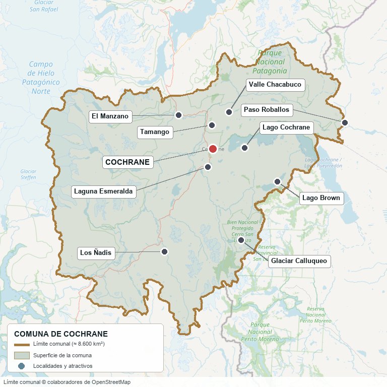
Commune boundary according to OpenStreetMap open data
§ 03 Location, Geography and Territory View
Where Cochrane is, what the town is built on, and why soil and water rule in this commune.
3.1 Location
The commune extends between latitudes 47° and 47°45′ south and longitudes 71°50′ and 73°45′ west. It borders Chile Chico to the north, O'Higgins to the south, Tortel to the west —the boundary runs over the Campo de Hielo Norte— and Argentina to the east, in Santa Cruz province. The only road that crosses it is Ruta 7 (Carretera Austral). From the plaza, Tortel is 126 km away, Chile Chico about 180, Villa O'Higgins about 230 and Coyhaique 331.
Plaza de Armas of Cochrane · 47°15′ S 72°34′ W
3.2 Terrain and setting
The town lies on the floor of the Río Cochrane valley, at about 200 m a.s.l. and some 45 m above the lake. Around it, the terrain is arranged from west to east: to the west, the ice fields and the mountain range that drops to the Pacific at the boundary with Tortel; toward the border, valleys and a wind-shaped plateau steppe, where ranching is done on coirón grass. Lenga and ñirre cover the slopes of the park.
The two landmarks of the terrain stand on either side of the town. Cerro Tamango, of nearly 1,700 m, rises some four kilometers northwest of the plaza. To the southeast, on the border with Argentina, is Monte San Lorenzo (3,706 m), called "Cerro Cochrane" in Chile: its summit lies about a thousand meters outside the commune's polygon, so it is correct to say that the commune reaches its massif, not that it contains it.
3.3 Hydrography
Main bodies of water in the commune7 rows
| Watercourse | Role in the territory |
|---|---|
| Río Baker | Chile's highest-volume river (875 m³/s, 170 km). It rises in Lago Bertrand, which belongs to Chile Chico, and in Cochrane it receives the Nef, the Chacabuco and the Cochrane before entering Tortel. It is the axis of the fishing lodges and of the El Manzano parcel corridor. |
| Lago Cochrane / Pueyrredón | 325 km² in total, 175 km² on the Chilean side; elevation 153 m and up to 460 m deep. It is split by the border with Argentina. Its outlet is the Río Cochrane, which flows past the town and empties into the Baker. |
| Río Chacabuco | Gives its name to the valley where the Compañía Ganadera Valle Chacabuco ranch stood and which today is occupied by the park's Chacabuco sector. |
| Río Nef | Tributary of the Baker on its western bank. Its confluence is where the rallies against the HidroAysén dams were held. |
| Laguna Esmeralda | Seven kilometers from town; it gives its name to a sector of lifestyle parcels with views of the Campo de Hielo Norte. |
| Lagos Brown, Chacabuco and Vargas | Lakes in the interior of the commune. The Brown is a fly-fishing site; the Vargas lies toward the boundary with the ice and is not an accessible attraction. |
| Glaciar Calluqueo | Tongue of ice from the San Lorenzo massif, accessible with registration and a fee at the San Lorenzo ranch. |
3.4 Soils
There is no published agrological study for Cochrane that would allow giving the soil class property by property: CIREN has only a preliminary study of part of Aysén province. What is documented is the regional picture: in Aysén, ranching takes place on class 4 to 7 soils, and class 3 soils are found almost only where there is irrigation; in Capitán Prat only 243 of the region's 2,819 irrigated hectares are watered. These are soils of volcanic origin, light and rich in organic matter, which the wind carries off when they lose their cover, and in the Cochrane area the tephra from the 1991 Hudson eruption has been identified.
- Advantage: lenga and ñirre forest and coirón and neneo steppe suited to low-stocking extensive ranching; land prices still low for large ranches.
- Limitation: almost everything is dryland. Summer is the dry season (February, 33 mm) and in Capitán Prat 243 ha are irrigated, 8.6 % of the region's irrigation.
- Risk: wind erosion where the grass is lost and damage from volcanic ash, as happened with the Hudson on August 8, 1991.
- Real estate implication: a property's price rarely reflects its soil class, because no one reports it; what is paid for is location and size. It is advisable to request an agronomic assessment before buying a "grassed" ranch.
§ 04 Climate and Seasonality View
A low-lying town with moderate rainfall, where frost can occur in the middle of summer.
The Dirección Meteorológica weather station "Lord Cochrane Ad." (196 m, 1.5 km south of town) records a temperate oceanic climate (Köppen Cfb), with rain concentrated between May and August. The figures that follow are the 1970-2000 normal, the latest published for the station that could be consulted; the DMC already works with the 1991-2020 normal, but it did not appear for Cochrane.
Reference climate parameters (DMC, 1970-2000 normal)10 rows
| Parameter | Typical value | Comment |
|---|---|---|
| Mean annual temperature | 9.4 °C | Average maximum 12.6 °C and average minimum 4.4 °C |
| Warmest month | January, 15.6 °C | Average maximum 19.3 °C |
| Coldest month | July, 1.8 °C | Average minimum of −1.0 °C; June averages 1.9 °C |
| Annual precipitation | 714.5 mm | 119 days with precipitation per year |
| Wettest months | May to August | Between 79 and 87 mm per month |
| Driest month | February, 32.6 mm | Eight rainy days |
| Average relative humidity | 63 % | 81 % in June, 51 % in January |
| Heat record | 36.1 °C | In February |
| Cold record | −16.2 °C | July 1995 |
| Absolute minimum of 0 °C or below | every month | Even January (−0.3 °C) and December (−0.6 °C) |
Rain is concentrated from May to August, when the mean temperature drops below 5 °C and in July reaches 1.8 °C, and February, with 33 mm, is the driest month: the water arrives in the coldest season and summer is the dry season, the same one in which the park's roads open.
There is no published series that would support stating a trend for Cochrane: data on sunshine hours, mean wind and days of frost per year were not found for this station and are therefore not included. What can be said is that anyone buying here should assume the climate of the historical normal and ask neighbors what the last winters have been like.
§ 05 History: the Relocated Town and the Valley That Changed Hands View
Cochrane was founded twice, and the neighboring valley went from sheep ranch to national park.
-
1899
The Baker is first ascended
The German explorer Hans Steffen goes up the Río Baker and surveys the valley where the ranches would later be leased. (Source: Diario Regional de Aysén, 2021.)
-
1904
The Sociedad Explotadora del Baker
The State leases it 797,500 hectares on the condition that it settle 40 families of colonists and ship production out through the Pacific. Among its partners are Juan Tornero and Mauricio Braun, of the Punta Arenas elite.
-
c. 1909
The Explotadora's failure
Fifty-nine of the company's workers die in unclear circumstances, allegedly poisoned to avoid paying them; the name "Isla de los Muertos" comes from these events, today a place in Tortel, not in Cochrane.
-
1916
Hobbs, Bridges and the sheep
The concession passes to the Sociedad Estancia Posadas, of Hobbs y Cía., which hires Lucas Bridges, raised in Tierra del Fuego. Bridges sets up the Bajo Piragua port at the mouth of the Baker.
-
1927-1929
The first town and its relocation
Settlers found a town at Las Latas, next to the Compañía Ganadera Valle Chacabuco ranch. Its shareholders did not want it so close and succeed in having it moved to a valley on the banks of the Río Cochrane. In 1929, with Aysén already a territory, the intendant Luis Marchant creates a land commission and the Explotadora's lease is reduced to the Chacabuco valley.
-
1931
First school
The Cochrane school is created, which Lucas Bridges hands over to the settlers.
-
17-03-1954
Pueblo Nuevo is inaugurated
During the government of Carlos Ibáñez del Campo the town is officially inaugurated, with a post office and ten houses, on land donated by the subdelegate Luis Báez Barra. Residents keep calling it "Pueblo Nuevo". In 1955 three surveyors lay out the blocks and lots.
-
1960-1984
Post office, hospital and high school
In 1960 the post office begins operating, in 1979 the hospital replaces the old rural clinic and in 1984 the Liceo Austral Lord Cochrane is created. Electricity came from the El Traro hydroelectric plant, which had succeeded the diesel engines.
-
1967
The Reserva Forestal Lago Cochrane is born
Supreme Decree 327 creates, on the El Húngaro lands, the reserve that tourists will know as Tamango.
-
1970-1975
From department to provincial capital
On October 26, 1970 the commune leaves the Chile Chico Department and joins the new Baker Department; with the regionalization of 1974-1975 it becomes the capital of Capitán Prat province. The decree creating the commune could not be located and is therefore not cited.
-
1980s
The Carretera Austral reaches Cochrane
Work resumed in 1976 with the Cuerpo Militar del Trabajo. A secondary source places the arrival in Cochrane in 1988; the date could not be confirmed with a primary source.
-
08-08-1991
The Hudson ash falls
The eruption of the Hudson volcano, the second most intense in Chile's history after that of Quizapu in 1932, covers a good part of Aysén in ash. The specific effect on Cochrane's ranching is not documented; an identifiable layer of tephra was left in the area.
-
2004
The Estancia Valle Chacabuco is sold
Conservación Patagónica, of Kristine McDivitt and Douglas Tompkins, buys the former ranch (from 69,000 to 90,000 ha depending on the source) from its Belgian owner.
-
2011-2014
HidroAysén approved and annulled
Five power plants on the Baker and the Pascua, 2,750 MW. Baker 1 would have flooded the El Manzano suspension bridge, 25 km north of Cochrane. On June 10, 2014 the Committee of Ministers revokes the permit (Agreement 23).
-
2017-2019
The valley becomes a park
In December 2017 the donation of 21 properties is accepted; on January 29, 2018 President Bachelet signs the Red de Parques decrees in Cochrane; on February 28, 2018 the ZOIT "Provincia de los Glaciares" is published; on December 11, 2018 the Diario Oficial creates Parque Nacional Patagonia (304,527.75 ha) and CONAF has administered it since April 30, 2019.
-
20-01-2022
The new hospital is inaugurated
President Piñera inaugurates the new Hospital de Cochrane, of some 5,000 m², which replaces the one built in the 1960s and 1970s.
§ 06 Cultural Identity and Indigenous Peoples View
One in four cochraninos identifies as belonging to an Indigenous people, and the town was settled by horsemen from Argentina and Magallanes.
In the 2024 Census, 847 people (24.5 %) declared themselves as belonging to an Indigenous people, compared with 29.0 % in the region and 11.4 % in the country. In 2017 the figure was 19.6 %, but the question changed between censuses and the rise should not be read as a real change. The breakdown by people from the 2024 Census was not published for the commune when this edition closed; in 2017 the majority group was Mapuche.
The cultural layers of Cochrane6 rows
| Tier | Visible traces today |
|---|---|
| Aonikenk and the peoples of the forest and ice | The Tehuelche or Aonikenk roamed the eastern part of the present commune; the Chonos and Kawésqar, the western part. There are traces of human occupation some 7,700 years old in the park's surroundings. |
| Spontaneous settlers | Chileans and children of Chileans born in Argentina who arrived between 1900 and 1920, before the state colonization policies of 1927-1930. |
| Company workers and ranchers | Workers hired in Chiloé by the Explotadora del Baker, and managers and ranchers who came from Magallanes and Tierra del Fuego, such as the Brauns and the Bridges. |
| Gaucho and cattle-drover culture | The Ruta de los Parques describes the area as "gaucho territory", with truco and chamamé; the ZOIT recognizes the Ruta de los Troperos as an attraction. |
| The embroiderers of the Baker | Women who hand-embroider tobacco pouches, sashes, handkerchiefs and tablecloths; there is a 2019 documentary and a 2021 gathering of 18 embroiderers. The municipality speaks of national recognition as intangible heritage, which could not be confirmed with the Ministerio de las Culturas. |
| Transient population | Public officials and road-works workers who arrive from other localities; according to Servicio País they form a significant floating population in town. |
The mix shows in the calendar more than in the streets: the Encuentro Costumbrista, which the municipality calls the oldest in Aysén and reached its XXV edition in 2025, has in the municipality a costumbrista park with a rodeo ring and a Chilean-style racetrack; and each October the Festival de la Escarcha brings together music and accordions. The search found no registered Indigenous lands or Indigenous development areas in the commune, but there is no public registry that rules them out either: before buying a large ranch it is advisable to ask CONADI.
§ 07 Key Demographic Data View
7.1 Population and growth
Comparative demographic indicators11 rows
| Indicator | Commune | Region | Country |
|---|---|---|---|
| Population, 2017 Census | 3,490 | — | 17,574,003 |
| Population, 2024 Census | 3,458 | — | 18,480,432 |
| Intercensal change | −0.9 % | −2.3 % | 5.2 % |
| Commune area | ≈ 8,600 km² | — | — |
| Population density (2024) | 0.40 inhab./km² | — | — |
| Foreign-born population | 2.6 % | 3.9 % | 8.7 % |
| Sex ratio 2024 | 106.0 | 97.9 | 94.3 |
| Demographic Dependency Ratio (IDD) 2024 | 48.0 | 46.3 | 46.5 |
| Elderly Index (IAM) 2024 | 65.0 | 66.2 | 79.0 |
| Rural population, 2024 | 21.8 % | 23.0 % | 13.3 % |
| Average schooling, 2024 | 9.5 years | 9.9 years | 10.4 years |
7.2 Age structure (2024 Census)
Population distribution by age group6 rows
| Age group | Population 2024 | % Commune |
|---|---|---|
| 0 – 14 years | 680 | 19.7 % |
| 15 – 29 years | 654 | 18.9 % |
| 30 – 44 years | 887 | 25.7 % |
| 45 – 64 years | 795 | 23.0 % |
| 65 years and over | 442 | 12.8 % |
| Total | 3,458 | 100 % |
The commune lost 32 people between 2017 and 2024 (the BCN prints the change without a sign: it is a decline of 0.9 %). Aging is faster than the country's: the Elderly Index rose from 45.1 to 65.0 in seven years, and the sex ratio fell from 119.8 to 106.0: there are still more men than women, but the gap has narrowed. School enrollment followed the same path: from 807 students in 2023 to 740 in 2025.
Of the 3,458 inhabitants, 2,703 live in the urban area and 755 in the countryside: 0.09 people per rural square kilometer. Buying a parcel in Cochrane is not settling on the edge of a town: it is buying real isolation. The 2024 Census figure for households and dwellings in the commune had not been published when this edition closed; in 2017 there were 1,243 households, 24.4 % of them single-person, and 1,771 dwellings of which 71.8 % had residents present.
§ 08 Economic and Socioeconomic Data View
8.1 Poverty and social indicators (CASEN and Social Household Registry)
Social indicators compared5 rows
| Indicator | Commune | Region | Country |
|---|---|---|---|
| Income poverty, Casen 2024 | 13.5 % | 14.3 % | 17.3 % |
| Multidimensional poverty, Casen 2024 | 9.9 % | 12.1 % | 17.7 % |
| People in households lacking basic services (RSH, Jun. 2026) | 15.8 % | 12.4 % | 12.9 % |
| Overcrowded households (RSH, Jun. 2026) | 5.8 % | 5.7 % | 7.8 % |
| Indigenous population (2024 Census) | 24.5 % | 29.0 % | 11.4 % |
The reading that emerges from the table runs against intuition: Cochrane appears less poor than the region and the country, but has worse access to basic services than both (15.8 % of people, versus 12.4 % and 12.9 %). A plausible explanation is the dispersion of the countryside: the 2020 PLADECO documents rural sectors without electricity, drinking water or sewerage. The Casen 2024 methodology changed and its figures are not comparable with those of 2022: one should not write that poverty "fell" or "rose". Reports of violent crimes are low (613 per 100,000 inhabitants in 2025, versus 1,003 in the country), although those for domestic violence rose from 374 to 773 between 2024 and 2025.
8.2 Economic activity (SII) and municipal finances (SINIM)
Business structure and municipal finances12 rows
| Economic indicator (SII / SINIM) | Value |
|---|---|
| Businesses domiciled in the commune (SII, 2022 · 2023 · 2024) | 471 · 497 · 519 |
| Business size, 2024 | 369 micro, 47 small, 4 medium, none large, 99 without sales |
| Reported salaried employees (2023 · 2024) | 598 · 475 |
| Commerce, 2024 | 115 businesses · 156 workers |
| Lodging and food service, 2024 | 96 businesses · 63 workers |
| Agriculture, ranching and forestry, 2024 | 62 businesses · 20 workers |
| Construction, 2024 | 62 businesses · 67 workers |
| Public administration (2023 · 2024) | 267 · 102 workers |
| Total municipal revenue, 2025 (SINIM) | M$ 5,720,961 (≈ $5,721 million) |
| Fondo Común Municipal share of total revenue, 2025 | 52.5 % |
| Permanent own-source revenue share of total revenue, 2025 | 8.8 % |
| Municipal revenue per inhabitant, 2025 | M$ 1,525, versus M$ 579 in the commune of Aysén |
The business structure is that of a service town: most are micro-enterprises in commerce, lodging and construction, and agriculture has 62 businesses but only 20 salaried employees, because they are family-run operations with no payroll. Formal employment depends on the State. Between 2023 and 2024 reported salaried employees fell from 598 to 475 and those in public administration from 267 to 102; the SII assigns each business its tax domicile and there is no official explanation for the drop, so the two figures should be read as a range and not as a trend.
§ 09 The Productive Engine: Grassland Ranching, the State and the Park View
Land in Cochrane is worth three different things: grass, proximity to town and scenery. Only the first is productive, and it is the one that is shrinking.
9.1 Natural-grassland ranching
Ranching is what gave rise to the town —sheep of the Explotadora del Baker, of the Chacabuco valley ranch and of the settlers— and it remains the productive use of the land, on coirón and natural grassland, almost all of it dryland: in Capitán Prat 243 of Aysén's 2,819 irrigated hectares are watered. The commune-level breakdown of the 2021 Agricultural Census (holdings, head of livestock, area) could not be extracted from the INE when this edition closed, so the livestock figures are regional; the only commune-level data is from the SII: 62 agriculture, ranching and forestry businesses, with only 20 salaried employees.
Livestock stocks in the Aysén Region (ODEPA, April 2026)5 rows
| Year | Cattle | Sheep |
|---|---|---|
| 2007 | 197,936 | 280,400 |
| 2013 | 144,037 | 243,850 |
| 2017 | 151,001 | 177,972 |
| 2021 | 130,832 | 177,934 |
| Change 2007-2021 | −33.9 % | −36.5 % |
Cattle counts holdings of 10 head or more and sheep of 60 or more, per the Census criterion. The decline is one third in fourteen years; in 2007 the average cattle holding in the region had 88 head, and most holdings in the region are small or medium. It is the floor that sustains the price of a ranch, and it is a floor that is sinking.
9.2 The State and commerce: the economy that pays payrolls
In 2023 public administration (the municipality, the hospital, the high school and the services with tax domicile in the commune) reported 267 of the 598 salaried employees: 44.6 %; in 2024 the SII recorded 102 of 475, a drop with no official explanation. Commerce, with 115 to 121 businesses depending on the year, is the largest sector by number of businesses and by private employment (145 to 156 employees). Between them they explain why a town that loses population keeps adding businesses (from 426 in 2021 to 519 in 2024): they are service micro-enterprises, not salaried employment.
9.3 Other economic pillars
- Tourism: 96 lodging and food-service businesses in 2024, employing 63 salaried workers. Parque Nacional Patagonia recorded 16,453 visitors in 2024 and 4,766 in 2023 (CONAF via Subturismo, 2026), far below the roughly 367,000 of Torres del Paine in 2024: these are the visitors who pass through CONAF ticketing, not the total of those who fly-fish or arrive at the lodges.
- Construction and road works: 62 businesses and 67 salaried workers in 2024. Workers of the public-works firms are part of the town's floating population (Servicio País, 2024-2025).
- Energy: HidroAysén planned five power plants on the Baker and the Pascua (2,750 MW) and its permit was annulled in 2014. Today the town receives power from the General Carrera medium-sized system, generated mostly with diesel (around 70 %, according to Edelaysen), and in 2025 the Ministerio de Energía selected Cochrane for pre-feasibility studies of a community solar park, with some 100 beneficiary families estimated.
- Mining: the SII records two businesses and six employees in mines and quarries in 2023; the operations registered by SERNAGEOMIN in the commune could not be verified.
- Fruit trees and vegetable gardens: a Río Colonia listing highlights the soil's capacity to produce fruit trees and vegetables; there are no commune-level figures for greenhouses or beekeeping (the region has 1,587 hives, 1.2 % of the country).
§ 10 Real Estate Market View
10.1 Available properties and property types
The land market in Cochrane is thin. On October 27, 2026 there were 32 lots and plots located in Cochrane on Yapo and 13 plots on ChilePropiedades, with many duplicates between portals; of the 32 on Yapo, 18 had been created in 2023 or 2024 and only 13 in 2026. Eighteen are posted by brokers and fourteen by their owners. Mercado Libre requires login and PortalTerreno has no listings in the commune; houses barely pass through portals. Among the advertisers are Ahumada Propiedades (the central lot steps from the plaza), Hobbins Propiedades (90 ha in El Manzano), Nexxos Chile (the "Patagonia Baker" subdivision) and Corretaje Carretera Austral.
Produncan Lands currently has two properties in the commune, both in the Baker corridor: the Lotes en Río Baker, El Manzano subdivision (ten 5,000 m² parcels with their own property roll (rol), 300 m from the river and 30 minutes from Cochrane; seven remain) and the Campo El Maitén, Río Baker (104.9 hectares with 3 km of riverfront, next to the confluence with the Nef, expandable to 416 ha).
10.2 Average price by property type (indicative, October 2026)
Indicative price ranges by property type (asking prices; UF = $41,195, Oct. 27, 2026)7 rows
| Property type | Indicative price range | Notes |
|---|---|---|
| Urban lot in town (up to 1,300 m²) | $80,000 to $446,000 per m² (median $116,000) | Only three listings. The one at $446,000/m² is a 325 m² lot steps from the Plaza de Armas ($145 million); the one at $116,000/m² has 1,250 m² with sewerage, electricity and water (UF 3,531). |
| Lifestyle parcel of 0.5 to 1.3 ha | $25 to $40 million per ha (median $31 million; ≈ UF 753) | Nine listings. A 5,000 m² parcel costs between $12.5 and $20 million. The exception is one next to the urban limit, at $85 million. |
| Parcel of 2 to 10 ha | $7.5 to $31.5 million per ha (median $18.9 million; ≈ UF 459) | Seven listings, with totals of $56 to $150 million. The $7.5 million per ha corresponds to 10 ha 10 km from town, in Laguna del Diablo. |
| Ranch of 15 to 60 ha | $10 to $16 million per ha (median $15.2 million; ≈ UF 369) | Three listings. A 16 ha ranch with 300 m of Baker shoreline and rights of 1 l/s asks UF 5,900. |
| Ranch of 60 to 300 ha | $2.5 to $6.5 million per ha (median $3.2 million; ≈ UF 77) | Six listings. A 109 ha ranch with a house, pastures and paddocks asks $350 million; one of 240 ha near the Baker, $750 million. |
| Ranch of more than 700 ha | $1.1 to $1.5 million per ha | Two listings: 769 ha with a river and lagoon toward Tortel ($1,153 million) and 1,680 ha in Colonia Sur ($1,848 million, October 2026). |
| Houses | No sample | A 11 × 25 m lot with two houses two blocks from the plaza ($175 million, September 2026) and an operating hostel (UF 9,500) are the only listings. |
Prices are asking prices, not closing prices, and the sample per tier is small: they serve to order magnitudes and not to appraise. The price per hectare falls more than twentyfold between the 5,000 m² parcel (about $31 million per ha) and the ranch of more than 700 ha ($1.1 to $1.5 million per ha): it is an almost perfect volume discount, and no one pays per hectare of ranch what they pay per hectare of lifestyle parcel.
10.3 What determines price in Cochrane
Valuation factors in this market, ranked by measured impact7 rows
| Factor | Price impact | How to check it here |
|---|---|---|
| Proximity to town with utility feasibility | 4 to 6 times: $85 million for 5,000 m² next to the urban limit, versus $12.5 to $20 million in the countryside | Ask the DOM what the "urban limit" is (there is no zoning plan). Request feasibility from Edelaysen and Aguas Patagonia. |
| Property size | 20 to 30 times per hectare between a parcel and a ranch of more than 700 ha | Always compare the total price and the price per hectare of properties in the same tier. |
| Baker riverfront | No price premium in the sample (n = 9) | The parcel 200 m from the Baker asks $12.5 million; riverfront, $16 million; 11 km from town and without river, $20 million. Check floods and winter access. |
| Electricity and water services | No measurable differential | One hectare on the slope of Tamango, with electricity feasibility and APR "in progress", asks $29 million: equal to the median. Require written feasibility from Edelaysen (free of charge). |
| Access road | Not measured | Ruta 7 is gravel up to Cochrane; the El Manzano lot is reached by 3 km of gravel from it. Ask Vialidad about winter condition. |
| Water rights | Not measured | Only 1 of 30 listings declares them (1 l/s). Request the DGA certificate. |
| Title deed | Not measured | Request a current copy at the Cochrane Registrar (Av. O'Higgins 437-B). There is no published commune-level data on properties with irregular title: it is requested through transparency from the Seremi de Bienes Nacionales de Aysén. |
§ 11 Land-Use Planning in Cochrane View
Cochrane has no zoning plan: what governs is rural land, a national park and a tourism designation.
There is no Communal Zoning Plan (PRC) in force (BCN, 2025 and 2026 reports: "not applicable"; SINIM 2023-2025). The municipality said in July 2025 that it has been working on it since 2002 and that it did not move forward because MINVU never resolved the observations; the Seremi de Vivienda reported that the Corecivyt planned to fund preliminary studies in 2026 for Cochrane, Tortel and Guaitecas. The current status of those studies could not be verified. In Aysén only three of ten communes have a zoning plan: Aysén, Cisnes and Coyhaique.
Instruments that govern land in Cochrane, in place of a zoning plan5 rows
| Instrument | What it governs | Key restriction |
|---|---|---|
| Rural land (art. 55 of the LGUC and DL 3,516) | The entire territory outside an urban limit that could not be located | In practice, listings sell 5,000 m² parcels "with their own property roll (rol)". The 2020 PLADECO notes that building permits were processed in Coyhaique: confirm with the DOM whether that is still the case. |
| PLADECO 2020-2026 | Municipal development plan; it guides investment, not zoning | It does not grant permits or define uses. There is also the "Provincia de los Glaciares" plan (Cochrane, Tortel and O'Higgins), Aysén's first lagging-zone plan, approved by the Regional Council in October 2019. |
| Parque Nacional Patagonia | 304,527.75 ha between Chile Chico and Cochrane; in Cochrane, the Chacabuco and Tamango sectors | Protected public land: it is not sold or subdivided. It creates a spillover effect on neighboring properties. |
| ZOIT "Provincia de los Glaciares" | Tourism in Tortel, Cochrane and O'Higgins (Decree 94 of 2018) | It is an instrument for tourism promotion and planning; it does not create a land-use zone for a property. |
| Native forest (Law 20,283) | Lenga, ñirre and coigüe, described in the ranch listings in El Manzano and toward Tortel | Felling requires a management plan approved by CONAF. A 90 ha listing in El Manzano mentions lenga forest and another of 769 ha toward Tortel, coigüe, lenga and ñirre. |
Without a zoning plan there are no risk areas declared by a planning instrument. The risks that are documented are operational: river floods that cut passage in Los Ñadis, roads that close with snow, frozen pipes in town and the volcanic ash of the 1991 Hudson, whose tephra remained in the soil of the area. The search found no declared urban wetlands (Law 21,202), historic zone or national monument within the commune.
The most important protection is the park's. The "Reserva Nacional Tamango" cited in older guides no longer exists: it was the Reserva Forestal Lago Cochrane (Supreme Decree 327 of 1967) and since the 2018 decree it has been a sector of Parque Nacional Patagonia, which CONAF has administered since April 30, 2019; today entry is with the park ticket. The areas that circulate for that reserve (6,900, 6,925 and 8,352 ha) do not match one another.
§ 12 Areas of the Town and the Commune View
Without a zoning plan, Cochrane has no official neighborhoods: it has a town of blocks laid out in 1955 around the Plaza de Armas and countryside organized around Ruta 7 and the valleys. The table lists the areas where there are listings or verified properties, from nearest to farthest.
Areas of Cochrane and their market profile9 rows
| Sector | Features | Market profile |
|---|---|---|
| Center and Plaza de Armas | Urban core: municipality, commerce, the hostel and the vacant lot steps from the plaza. A lot with two houses two blocks from the plaza and three from the hospital asks $175 million. | Most expensive land: up to $446,000 per m². Very scarce. |
| Calle Río Los Ñadis (urban) | Large lots with sewerage, electricity and water inside the consolidated area. | Around $116,000 per m². |
| Slope of Tamango | Four kilometers to the northwest, next to the park's Tamango sector, with views of the town and the valley. | Lifestyle: 1 ha at $29 million, with electricity feasibility and APR "in progress". |
| Laguna Esmeralda | Seven kilometers away; parcels with views of the lagoon and the Campo de Hielo Norte, 10-15 minutes from town. | Lifestyle and second homes, from $31 to $32 million per ha. |
| Laguna del Diablo | 10-11 km away, on a paved road for the first ten kilometers. | Lifestyle and small tourism projects: from $7.5 to $40 million per ha. |
| Río Baker corridor (El Manzano, El Maitén, Entrada Baker, confluence with the Nef) | 28-31 km from town; several listings, and the El Manzano subdivision itself, state they have no electricity. It is the axis of fly-fishing and the lodges. Produncan's El Manzano subdivision and Campo El Maitén are here. | 5,000 m² parcels from $12.5 to $16 million; ranches of 16 to 104 ha, from $4.5 to $15 million per ha. |
| Río Colonia | About 42-43 km away; access partly on horseback and by raft over the Baker. | Large isolated ranches, from $0.7 to $3.2 million per ha. |
| Ruta 7 toward Tortel (rural Los Ñadis, Laguna Los Patos) | Between 45 and 60 km from town, on the road to Tortel. A couple of listings "40 km from Tortel" may be in the neighboring commune. | Roadside ranches, up to $1.5 million per ha. |
| Valle Chacabuco and Tamango (park) | Sectors of Parque Nacional Patagonia at 27 and 4 km: no sale listings because they are public land. | Not tradable. Spillover effect on the surroundings. |
§ 13 Basic Services, Utilities and Digital Connectivity View
Operational information that rarely appears in descriptions of a commune and that determines whether a parcel is habitable.
Service providers and coverage7 rows
| Service | Provider / operator | Practical notes |
|---|---|---|
| Electricity | Edelaysen (Grupo Saesa), General Carrera medium-sized system | Mostly diesel generation. Feasibility is free and is answered in 8 business days (10 in low density, 15 in extremely low); in low density the connection can take up to 30 business days if the extension is under 3 km and up to 60 if it is 3 km or more. There is no published rate for the rural connection. |
| Urban drinking water | Aguas Patagonia de Aysén S.A. | Serves the town. In winter the pipes freeze and supply has been suspended for weeks (Servicio País, 2024-2025). |
| Rural drinking water | APR committees and cooperatives | No operating APR was identified in the commune. The 2020 PLADECO projects one in El Húngaro, Embarcadero and Puente Escobar and drinking water in Millacura; in the countryside water comes from a well, spring, river or water truck. |
| Sewerage | Aguas Patagonia (urban) | The town has a treatment plant; in the countryside there is no network and septic tanks are used. |
| Gas | No piped network | Bottled liquefied gas is used; there is no verified price or distribution network. |
| Heating | Firewood | Cochrane has a particulate-matter monitoring station and the Ministerio del Medio Ambiente has called for heater-replacement programs in the commune. In Aysén, 18.3 m³ of firewood per household per year. |
| Internet and phone | Fibra Óptica Austral (wholesale backbone) and mobile operators | The backbone has interconnection points in Cochrane and Los Ñadis since 2021, but it does not reach homes. There is mobile coverage in town and in El Manzano (3G); in Valle Chacabuco there is no signal. Satellite internet: no verified data. |
§ 14 Health View
For those settling on a parcel in Cochrane, the critical distance is not to the hospital but to the second hospital.
The commune's public health depends on the Servicio de Salud Aysén, and primary care is provided by the hospital itself: the July 2026 DEIS registry lists no CESFAM, CECOSF, rural clinic or SAMU in the commune. The Fonasa-validated population registered for primary care was 3,047 people in December 2025.
Health network of the commune2 rows
| Facility | Type | Detail |
|---|---|---|
| Hospital de Cochrane (Av. Bernardo O'Higgins 755) | Low-complexity hospital | New since January 2022: about 5,000 m², 7 clinical beds and 2 pediatric, emergency and surgical operating rooms, 10 consultation rooms, 2 emergency rooms, 3 procedure rooms, 2 dental rooms and 2 radiology rooms. Accreditation maintained in 2026. |
| Regional benchmark | Hospital Regional de Coyhaique | 331 km along Ruta 7, largely gravel. |
The hospital serves Capitán Prat province and Bertrand and Guadal, some 5,000 people in total. There is a shortage of specialists and the 2020 PLADECO reported that births were not handled in the commune: mothers were referred to Coyhaique before the due date. The new hospital includes a delivery room, and whether it is used today could not be verified. The commune's general mortality was 6.7 per thousand in 2023 (5.6 in the region and 6.1 in the country), with a birth rate of 8.84 per thousand.
§ 15 Education View
15.1 School education
Cochrane has two schools with enrollment, both of the Servicio Local de Educación Pública (formerly municipal), plus two preschools. There are no rural schools or subsidized private schools. Enrollment fell from 807 students in 2023 to 740 in 2025 (−8.3 %): 86 in early childhood education, 407 in primary, 205 in youth science-humanities secondary and 42 in adult secondary.
Facilities in the commune3 rows
| Facility | Type | Distinction |
|---|---|---|
| Escuela Básica Teniente Hernán Merino Correa | Servicio Local de Educación | Pre-kindergarten to 8° básico (Grade 8) and special school. The town's first school dates from 1931. |
| Liceo Austral Lord Cochrane | Servicio Local de Educación | Science-humanities secondary and adult education, created in 1984; Liceo Bicentenario since 2020. It has a boarding facility, whose replacement the PLADECO anticipates; its current condition was not verified. |
| Nursery and preschool "Mi Baker" and Jardín Integra "Los Pioneros" | Municipal and Integra | The town's early childhood education. |
SIMCE 2025 results (preliminary as of July 15, 2026)7 rows
| SIMCE test | Commune | Region | Country |
|---|---|---|---|
| 4° básico (Grade 4) · Reading | 269 | 276 | 276 |
| 4° básico (Grade 4) · Mathematics | 264 | 257 | 262 |
| 8° básico (Grade 8) · Reading | 233 | 229 | 238 |
| 8° básico (Grade 8) · Mathematics | 262 | 252 | 258 |
| 8° básico (Grade 8) · History | 251 | 245 | 250 |
| 2° medio (Grade 10) · Reading | 261 | 246 | 250 |
| 2° medio (Grade 10) · Mathematics | 281 | 261 | 263 |
The Bicentenario high school is the commune's best educational news: in 2° medio (Grade 10) it exceeds the region by 15 points in reading and 20 in mathematics, and the country by 11 and 18. By contrast, 4° básico (Grade 4) reading (269) falls below the region and the country (276). These are preliminary results from a high school with 205 regular secondary students, so a single year can swing considerably.
15.2 Higher education
There is no university campus or technical training center with a verified presence in the commune; the 2020 PLADECO lists as a need a technical training center for tourism and drinking water. Those who study after secondary school must go to Coyhaique, or farther.
§ 16 Park, Ice Fields and Rivers: the Natural Setting View
Cochrane is the gateway to two of the sectors of Parque Nacional Patagonia that lie within its territory —Tamango and Valle Chacabuco— and the base for reaching the San Lorenzo massif and the great rivers of the Baker. The table lists what is less than a day's travel away, with the road distance from the plaza and the estimated time where there is no official data.
Natural attractions by distance from the plaza of Cochrane8 rows
| Attraction | Approx. distance | Activities |
|---|---|---|
| Parque Nacional Patagonia, Tamango sector (formerly Reserva Forestal Lago Cochrane) | 4.3 km northwest; about 10 min by car (estimated) | Trails to the Elefantina and Tamanguito lagoons and to Cerro Tamango (nearly 1,700 m), South Andean deer sightings, boat trip on the Río Cochrane, camping. 2025-26 entry: $4,000 for Chileans aged 18 to 59 and $8,000 for foreigners. |
| Laguna Esmeralda | 7 km; 10-15 min (estimated) | Hike, view of the Campo de Hielo Norte and ascent of the Cordón Esmeralda. |
| Parque Nacional Patagonia, Valle Chacabuco sector | About 27 km; 30-40 min (estimated) | Visitor center and park offices, three campgrounds (October to April, $8,000 per person), guanacos, pumas and condors. No cell signal. |
| Lago Cochrane / Pueyrredón | The town is about 7 km from the lake | Fishing and views. The Chilean part covers 175 km². |
| Baker–Nef confluence | About 31 km as the crow flies (road not verified) | Fly fishing, kayaking and rafting on the Baker; the rallies against the dams were held here. |
| Glaciar Calluqueo and the Monte San Lorenzo massif | About 55 km via roads X-901 and X-911; 1 to 1.5 h | Glacier hiking and climbs. Entry is with registration and a fee at the San Lorenzo ranch. The summit (3,706 m) is on the border, outside the commune's polygon. |
| Paso Roballos | 95 km via the X-83 | Crossing to Argentina; closes in winter. |
| Outside the commune: Puerto Bertrand, Caleta Tortel and the park's Jeinimeni sector | Bertrand, between 44 and 60 km to the north; Tortel, 126 km; Chile Chico, about 180 km | They belong to Chile Chico (Bertrand and Jeinimeni) and to Tortel. They are part of the same circuit, but are not in the commune. |
Cochrane's natural setting: Tamango, Chacabuco, Lago Cochrane and Baker
Parque Nacional Patagonia comprises 304,527.75 hectares across the communes of Chile Chico and Cochrane (Agreement 22 of 2018 of the Council of Ministers for Sustainability) and absorbed the former Reserva Forestal Lago Cochrane (Tamango) and the Reserva Nacional Lago Jeinimeni. The emblematic fauna is the South Andean deer: in 2007 Tamango was estimated to hold between 40 and 60 individuals, and the Ruta de los Parques states that about 10 % of Chile's South Andean deer live in the park; there is no recent verified census. In the Chacabuco valley the most abundant herbivore is the guanaco, and there are pumas with GPS collars, condors and Darwin's rheas.
§ 17 Connectivity and Transportation View
17.1 Road network
Ruta 7 (Carretera Austral) is the only road that crosses the commune. It is paved from Coyhaique to Villa Cerro Castillo (about 98 km) and gravel from there to Cochrane. In 2026 the MOP began paving 16.2 km between Bahía Murta and Puente El Belga, in the commune of Río Ibáñez; within Cochrane, the Confluencia–Puente Chacabuco stretch was 15 % complete in April and the Cruce El Maitén–Puerto Guadal stretch obtained toma de razón (Comptroller's clearance). The government's goal is to have the route between Puerto Montt and Cochrane (more than 780 km) continuously paved by 2030; figures for how much of the Carretera Austral is paved today do not match across sources, ranging between 45 % and 58 %.
Routes and distances from Cochrane7 rows
| Route / destination | Distance and details |
|---|---|
| Coyhaique | 331 km along Ruta 7 (other sources give between 327 and 334 km). It is the reference destination for the regional hospital, regional paperwork and supplies. |
| Balmaceda Airport | 262 km, 5 h 15 min by car according to Produncan's fact sheet (2026); it is the nearest commercial airport. |
| Chile Chico | About 180 km along Ruta 265, which leaves Ruta 7 at the El Maitén junction and passes through Puerto Bertrand and Puerto Guadal (both in Chile Chico). |
| Caleta Tortel | 126 km along the branch of the Carretera Austral built in 2003; by bus, about 4 hours. |
| Villa O'Higgins | About 230 km south along Ruta 7. |
| Paso Roballos | 95 km via the X-83; closes in winter. The 2026 hours of Gendarmería, PDI and Customs were not verified. |
| Valle Chacabuco | 27 km via the X-83 to the park offices. |
Cochrane on the Carretera Austral axis, between Coyhaique and Villa O'Higgins
17.2 Airfield
The Lord Cochrane airfield lies northwest of town, next to the Chilean-style racetrack, and serves private flights and air taxis. Regular commercial flights could not be verified: the nearest commercial airport is Balmaceda, 262 km away, where Sky and LATAM operate.
Cochrane airfield fact sheet (AIP Chile, 2017 data)5 rows
| Fact | Detail |
|---|---|
| Name and codes | Aeródromo Lord Cochrane · ICAO SCHR · IATA LGR |
| Elevation | 196 m a.s.l. |
| Runway | 07/25, 1,060 m, paved |
| Other airstrips in the commune | Los Ñadis (SCND, grass, 588 m), Entrada Baker (SCEB, gravel, 700 m) and Lago Vargas (SCVS, grass, 655 m) |
| Scheduled flights | Not verified |
17.3 Land transport
- Bus terminal: the municipal terminal dispatches to Coyhaique with a daily morning departure (Acuario 13, Don Carlos and Águilas Patagónicas, according to Ruta de los Parques), and to Caleta Tortel, Villa O'Higgins and Chile Chico. Current frequencies and fares were not verified.
- Transport to the park: there is no public transport to Tamango or to Valle Chacabuco; without your own car you have to hire a transfer.
- Winter: Ruta 7 stays open all year with caution; roads to other localities require chains and the park circuits close from April to October.
§ 18 Tourism: Development, Attractions and Things to Do View
18.1 Tourism development
The most important instrument is the Zona de Interés Turístico "Provincia de los Glaciares" (Decree 94 of the Ministerio de Economía, published on February 28, 2018), which groups Tortel, Cochrane and O'Higgins and sets a 2030 vision of a sustainable destination with "untamed nature" and "millennial ice". The decree recognizes as traditional the Ruta del Huemul and the Desafío San Lorenzo, and as attractions the ice fields, sport fishing, the Ruta de los Troperos, the Baker and the Carretera Austral. The region is promoted under the "Aysén Patagonia" brand, and Cochrane is one of the gateways to the Ruta de los Parques de la Patagonia. No communal tourism development plan (PLADETUR) was found to cite.
Tourism numbers are meager: Parque Nacional Patagonia recorded 7,562 visitors in 2020, 4,766 in 2023 and 16,453 in 2024 (CONAF and Subsecretaría de Turismo), but they count only those who pass through park ticketing. In 2016 Cochrane was among the three localities in Aysén with the most adventure-tourism services registered by Sernatur. Current figures for arrivals, beds and overnight stays in the commune could not be verified.
18.2 Tourist attractions in the commune
- Tamango: four kilometers from the plaza, it is the park sector closest to town; the South Andean deer that appears on the national coat of arms takes refuge there.
- Valle Chacabuco: the valley of the former ranch, now a park, with a visitor center and a lodge with a restaurant.
- Laguna Esmeralda: seven kilometers away; view of the ice of the Campo de Hielo Norte and base for the ascent of the Cordón Esmeralda.
- Lago Cochrane / Pueyrredón: 460 m maximum depth, shared between Chile and Argentina.
- Glaciar Calluqueo and Monte San Lorenzo: the glacier can be walked with registration at the ranch; the summit of San Lorenzo, at 3,706 m, was first climbed on December 17, 1943 by the Italian Alberto De Agostini with Alejandro Hemmi and Heriberto Schmoll.
- Río Baker: Chile's highest-volume river; fly fishing on the Baker, the Cochrane and Lago Brown.
18.3 Museums and culture
- Centro Cultural de Cochrane: it has a 2022-2027 Management Plan and is the institutional space of local culture.
- Municipal library: San Valentín 554, with free wifi.
- Artisan market and museum: the Ruta de los Parques lists them among the town's services; their hours were not verified.
- The embroiderers of the Baker: a living craft, with a 2019 documentary and a 2021 gathering of 18 embroiderers that ended with a textile mural.
18.4 Food and dining
Cochrane's cuisine is that of ranching Patagonia. No locally documented dining offer was found from reliable sources, beyond a business directory that lists about 16 restaurants and 50 lodgings, with no year.
- Cordero al palo: a typical Aysén dish, roasted over embers on an iron spit, with potatoes, rice or salad and pebre.
- Gaucho culture: the Ruta de los Parques describes the territory as "gaucho", with truco and chamamé.
18.5 Nature and the outdoors nearby
- Ruta del Huemul: 30 km trek between Valle Chacabuco and Tamango.
- Fly fishing: on the Baker, the Cochrane and Lago Brown.
- Boat trip and snorkeling on the Río Cochrane: about $40,000 per group of eight plus entry, in the 2025-26 season.
- Cochrane Patagonia Trail and Carrera Aventura San Lorenzo: mountain races, with new editions announced for 2027.
- Park campgrounds: Tamango ($6,000 per person) and the three in Valle Chacabuco ($8,000 per person), from October to April.
18.6 Calendar of events and traditions
Main events of the year5 rows
| Period | Event | Character |
|---|---|---|
| February | Encuentro Costumbrista (XXV edition in 2025) | Ranching-tradition festival; the municipality describes it as the oldest in Aysén. |
| January to February (and June according to Ruta de los Parques) | Ruta del Huemul (XX edition, February 1 and 2, 2025) | 30 km trek between Chacabuco and Tamango. |
| March 17 | Town anniversary (72nd in 2026) | Civic ceremony for the 1954 founding. |
| October | Festival de la Escarcha | Music and accordion gathering. |
| 2027 | Cochrane Patagonia Trail (VII) and Aventura San Lorenzo (XII) | Mountain races already announced by the municipality. |
§ 19 Everyday Life, Sport and Practical Information View
What anyone who is going to live in Cochrane, not just visit it, needs to know.
19.1 Sport and identity
- Estadio Municipal Luis Gómez Triviño: natural grass and stands.
- Gimnasio Municipal: covered, with a parquet court; the 2020 PLADECO rated it in fair condition.
- Estadio Aoniken: grass field.
- Rodeo ring and Chilean-style racetrack: in the municipality's costumbrista park.
- Rural clubs: clubhouses and fields on loan (comodato) in the countryside sectors.
19.2 Shopping and supplies
The offering is that of a town of 2,700 urban inhabitants: minimarkets around the Plaza de Armas, the largest of them on the plaza itself, a pharmacy, a gas station, a mechanic's shop and an ATM that guides describe as the last one on the Carretera Austral heading south. The SII records 115 commerce businesses in 2024. For what is not available, the reference city is Coyhaique, 331 km away.
19.3 Where to handle paperwork
Offices based in Cochrane6 rows
| Office | Address or contact | Remarks |
|---|---|---|
| Cochrane Notary Office, Real Estate Registrar (Conservador de Bienes Raíces) and Archivist | Av. Bernardo O'Higgins 437-B · tel. 67 2522301 | Monday to Friday, 9 to 1 and 3 to 6 p.m. According to directories, its jurisdiction includes Tortel and O'Higgins. Registering title does not require traveling to Coyhaique. |
| Municipality | Esmeralda 398 · +56 67 2 522 115 · partes@municochrane.cl | The municipality has only a public works department; the 2020 PLADECO notes that building permits were processed in Coyhaique. |
| Hospital de Cochrane | Av. Bernardo O'Higgins 755 | The commune's only health facility. |
| IPS ChileAtiende | Río Maitén 518 | Serves the entire province (2023 data, to be confirmed). |
| Visitor center and tourism office | Dr. Steffens at Esmeralda · turismo@municochrane.cl | Visitor information. |
| Registro Civil, SII, Tesorería, SAG and Bienes Nacionales | — | No office in Cochrane was verified. The regional offices are in Coyhaique. |
19.4 Cost of living and practical considerations
- There is no published commune-level cost-of-living index; what is documented are the costs of isolation: firewood (in Aysén, 18.3 m³ per household per year) and freight from Coyhaique, 331 km away.
- Town water can run short for weeks in winter (Servicio País, 2024-2025); in the countryside you must count on a well, spring or water truck.
- The gravel Ruta 7 and the weather close secondary roads in winter; anyone living in the countryside should have provisions and firewood for several weeks.
- Health care is low-complexity: specialists and, according to the 2020 PLADECO, births are handled in Coyhaique.
- Reports of violent crimes are lower than in the region and the country (613 per 100,000 inhabitants in 2025 versus 1,003 in the country).
§ 20 Territorial Analysis: Strengths, Challenges and Opportunities View
An honest reading of the territory. A sound investment decision also requires knowing what doesn't work.
- Parque Nacional Patagonia at the door: Tamango 4 km from the plaza and Valle Chacabuco 27 km away, within a park of 304,528 ha.
- Full services for its size: a new hospital since 2022, a Bicentenario high school with 2° medio (Grade 10) SIMCE scores above the country's (281 versus 263 in mathematics), a notary with registrar and a paved airfield.
- Land that is still accessible: a 5,000 m² parcel facing the Baker costs between $12.5 and $16 million, and a 100 to 240 ha cattle ranch between $3 and $4.5 million per hectare.
- A municipality with room to maneuver: $1.5 million of revenue per inhabitant in 2025, more than two and a half times that of the commune of Aysén.
- Low rate of violent crime: 613 reports per 100,000 inhabitants in 2025, versus 1,003 in the country.
- Depopulation: 3,458 inhabitants in 2024, 32 fewer than in 2017, while the country grew 5.2 %; school enrollment fell 8.3 % between 2023 and 2025.
- No zoning plan: there is no zoning, no locatable urban limit and no declared risk areas, and building permits were processed in Coyhaique.
- Insufficient rural services: 15.8 % of people live in households lacking basic services, no APR was identified and several countryside sectors still have no electrical grid.
- Dependence on the State: 267 of 598 salaried employees were in public administration in 2023 and 52.5 % of municipal revenue comes from the Fondo Común Municipal.
- A productive sector in retreat: Aysén's cattle and sheep fell 34 % and 37 % between 2007 and 2021.
- Distance: 331 km to the regional hospital on a road that, from Villa Cerro Castillo, is gravel.
- Ruta 7 paving: the Confluencia–Puente Chacabuco stretch was 15 % complete in April 2026 and the government's goal is continuous paving of Puerto Montt–Cochrane by 2030.
- A zoning plan in preparation: MINVU projected preliminary studies for 2026 for Cochrane, Tortel and Guaitecas.
- Nature tourism: the ZOIT "Provincia de los Glaciares" and the Ruta de los Parques position the town as a gateway, and the park went from 4,766 to 16,453 registered visitors between 2023 and 2024.
- Distributed energy: Cochrane was selected in 2025 for studies of a community solar park that would benefit some 100 families.
- Backbone fiber optic with interconnection points in Cochrane and Los Ñadis since 2021, the basis for any last-mile improvement.
- Thin market and asking prices: 18 of the 32 Yapo lots have listings from 2023 or 2024, and the same ranch came to be listed with two very different prices.
- Baker water rights 100 % allocated since the HidroAysén era: a hydroelectric project could be proposed again, although none is in force today.
- Climate and isolation: absolute minimums of 0 °C or below every month (record of −16.2 °C) and pipes frozen for weeks in town.
- Volcanic ash: the Hudson covered the area in tephra in 1991 and its recurrence is uncertain.
- Border restriction: if the property is in a declared border zone, buyers from neighboring countries are subject to DL 1,939.
Cochrane: Territory, Connectivity and Opportunities
Cochrane is a town of 3,458 inhabitants that sustains a hospital, high school, notary and airfield for an entire province, with a national park at its door, the Nef, Chacabuco and Cochrane rivers joining the Baker within its territory, and a 5,000 m² parcel that is still offered from $12.5 million. What is missing —a zoning plan, rural water, grid electricity in the countryside, a paved road to Coyhaique— is also what explains that price, and what a well-informed buyer can see as an opportunity or as a cost, but not ignore.
At Produncan Lands we know this territory and its opportunities. We have two properties in the Baker corridor: the Lotes en Río Baker, El Manzano subdivision, with 5,000 m² parcels with their own property roll (rol), and the Campo El Maitén, Río Baker, of 104.9 hectares. Our work is to connect properties with people who are looking to invest, live and develop new projects in southern Chile, offering our experience, local knowledge and commercial reach.
We invite you to get to know our properties in Cochrane and throughout southern Chile, and to entrust Produncan Lands with the sale of your property.
View properties at Produncan Lands§ 22 Sources and Methodology Note View
22.1 Sources consulted
Documents and sources used15 rows
| Scope | Document and year |
|---|---|
| Population, social and economy | Reporte Comunal 2026: Cochrane, BCN, with data from the INE (2024 Census), MDS (Casen 2024 and RSH), SII, SINIM, MINEDUC, DEIS-MINSAL, CEAD and SERVEL; Reporte Comunal 2025 for the 2023 SII. |
| Planning and development | PLADECO 2020-2026 de Cochrane, Municipalidad de Cochrane, prepared by Mapocho Consultores (2020). |
| Zoning plan | Radio Santa María, «Cámara Chilena de la Construcción alerta que siete de diez comunas no cuentan con plan regulador», July 21, 2025. |
| Climate | Ficha de la estación Lord Cochrane Ad. (470001), Dirección Meteorológica de Chile; 1970-2000 normal. |
| History | Memoria Chilena sobre el valle del Baker; Diario Regional de Aysén, March 2021; Plan de Gestión del Centro Cultural de Cochrane 2022-2027, Ministerio de las Culturas. |
| Parque Nacional Patagonia | Acuerdo 22 de 2018, Consejo de Ministros para la Sustentabilidad; Ruta de los Parques de la Patagonia. |
| Tourism | Decreto 94 de 2018, ZOIT «Provincia de los Glaciares», Diario Oficial of February 28, 2018; Municipalidad de Cochrane, 2026. |
| Ranching | Región de Aysén: actualización abril 2026, ODEPA, with the 2007-2021 Agricultural and Forestry Census. |
| Real estate market | Sample of sale listings from October 27, 2026 on Yapo and ChilePropiedades; UF at $41,195. |
| Health | Inauguración del Hospital de Cochrane, Minsal, 2022; registro del hospital, Superintendencia de Salud. |
| Basic services | Consideraciones técnicas y plazos de conexión, Edelaysen; Informe de la Región de Aysén 1T 2024, Subtel; Programa Integral Territorial Cochrane 2024-2025, Servicio País. |
| Connectivity | Plan de pavimentación de la Carretera Austral, CPI, April 2026. |
| Housing and energy | Bienes Nacionales transfiere 43 hectáreas en Cochrane, April 2025; Parques solares comunitarios, Ministerio de Energía, May 2025. |
| Volcanism | Erupción del Hudson de 1991, ONEMI. |
| Notary and registrar | Notaría, Conservador y Archivero de Cochrane. |
22.2 Methodology note and data currency
- The SIMCE 2025 results (as of July 15, 2026) and the CASEN 2024 figures are preliminary, estimated by small area with a new methodology that is not comparable with that of 2022.
- Could not be verified and therefore was not written: the law or decree creating the commune; the 2024 Census breakdown by Indigenous people; 2024 Census households and dwellings by commune; the 2021 Agricultural Census by commune; the urban limit and risk areas; scheduled flights; bus frequencies and fares; the cost of a rural electrical connection; the price of liquefied gas; sunshine hours, wind and frost days; soil class by sector; and which lands are in a border zone.
- The commune's area has several official figures (8,560 to 8,662 km²); the document uses that of the BCN 2026, 8,599.5 km².
- The name "Cochrane" is documented for the river and the lake, not as a direct tribute by the town to Thomas Cochrane; who named the lake could not be established.
- The price ranges for the real estate market are indicative, come from asking prices on portals and do not constitute an appraisal. Each property must be evaluated individually.
- This document does not constitute legal or tax advice.
- Cut-off date of this edition: October 2026. It is recommended to review the indicators in sections 7, 8 and 10 annually.
Territorial reference document prepared by Produncan Lands. It brings together official information (INE, BCN, SII, SINIM, MINEDUC, ODEPA, MINSAL) with local market knowledge, so that anyone —neighbor, visitor, investor or buyer— can understand Cochrane in depth before making a decision. What could not be verified was not written: section 22 lists it.